Hiking Trails in Arizona
Arizona's diverse landscape makes it a beautiful state to explore on foot. You can hike through saguaros in the desert or ponderosa pines in the mountains, depending on where your travels take you. From the depths of the Grand Canyon to the unique formations of the Chiricahua Mountains, to the stunning red rocks of Sedona, you can expect to be amazed.
The day hikes selected here offer access to some of the most interesting natural features in Arizona. Canyons, mesas, volcanoes, bizarre rock formations, and plant life you can only find in the Sonoran Desert make this an incredible place to stretch your legs.
Many of these are easy hikes that can be done by anyone. A couple are epic, bucket-list hikes that the average hiker may not want to undertake.
Plan your adventures with our list of the best hikes in Arizona.
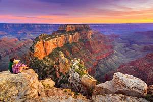
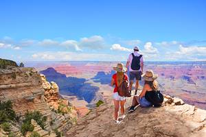
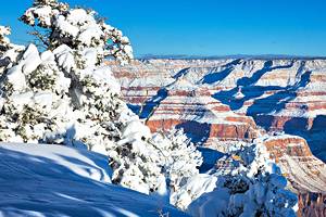
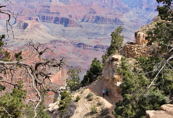
Bright Angel Trail, Grand Canyon
It's not surprising that one of Arizona's most renowned hikes is found at one of America's most astounding natural wonders.
Bright Angel Trail takes you from the edge of the South Rim of the Grand Canyon down into the canyon. You can hike right down to the Colorado River but this generally requires more than just a single day.
Several points along the trail offer good day-hike destinations and allow you to make this anywhere from a half-mile hike to a strenuous 12-mile hike.
The trail is steep and hugs the canyon wall, with huge drop-offs on the outer edge. Anyone with a fear of heights may want to think twice before starting off on this trail.
Bright Angel is just one of many hikes at the Grand Canyon. You can opt for easier trails, which may be a better option for people with limited time or who don't want to expend as much energy.
Conditions vary considerably by season, from icy and snow-covered in the winter to baking hot in the summer. The best time to visit the Grand Canyon for hikers is generally the spring and fall.
The National Park Service has recently made significant (and much needed) improvements to the Bright Angel Trailhead that include more parking, drinking water, and modern washrooms.
Bull Pasture/Estes Canyon Loop Trail, Organ Pipe Cactus National Monument
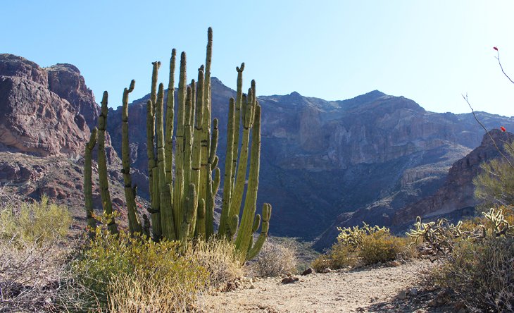
This often overlooked park, in the far south of Arizona near the Mexico border, offers some amazing sights and an incredible hiking trail.
The main draw for visitors to this area is a chance to see organ pipe cactuses, which in Arizona are only present in the farthest southern reaches of the state.
The Bull Pasture/Estes Canyon Loop Trail takes you up into the mountains, through some incredible scenery, and offers views over the canyon, desert, sheer cliff walls of the mountains you are climbing on, and views off to the mountains in Mexico. Saguaros and organ pipe cactuses line the trail and the mountain side, and wildlife is abundant.
From the parking area, the Bull Pasture trail leaves to the right, and the Estes Canyon Trail leaves to the left, and eventually these two trails connect on a high ridge.
Where they join, you'll see a spur that climbs up another half-mile over steep terrain. This side spur is only .5 miles each way, but it is quite steep.
The trail can be done as an in-and-out hike to Bull Pasture, which is three miles round trip, with 1,000 feet of elevation. Or, you can opt to hike the 3.2-mile in-and-out Estes Canyon Trail.
Many people join these two hikes for a loop, taking Bull Pasture to Estes Canyon trail without actually going all the way up the side spur to the pasture, for a 2.6-mile loop hike.
If you have plenty of energy and don't mind the climb, do this loop and add on the side spur all the way up to the actual bull pasture. Total elevation gain on this hike is about 1,000 feet.
The park describes the hike as having exposed cliffs, but these are not sheer cliffs immediately off the trail, and even people with some fear of heights should be fine on the trail.
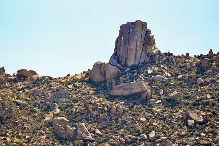
Echo Canyon Trail, Chiricahua National Monument
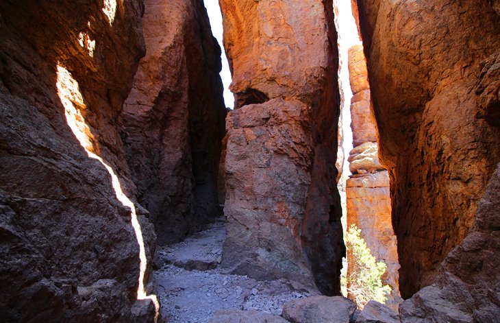
This land of rock pinnacles high above the desert is an independent mountain range, off on its own, known as a sky island. Hiking here, along the ridges and through the canyons, among the towering stone structures, is unique in Arizona.
The most popular trail is Echo Canyon Trail, a 3.5-mile loop trail with an elevation gain of 454 feet, which takes you through the heart of some of the most scenic landscape.
The trail runs through narrow passages, between the spires and through a slot in the rocks known as "wall street." Following along a mountainside for a considerable distance, you can look across to the pinnacles glowing in the late afternoon sun.
If you are interested in a longer hike, the Big Loop links several trails, including a portion of Echo Trail, to form a seven-mile hike.
Chiricahua National Monument is located in the far southern portion of Arizona and set out on its own. There is no accommodation here, but it is one of the best places to camp in Arizona.
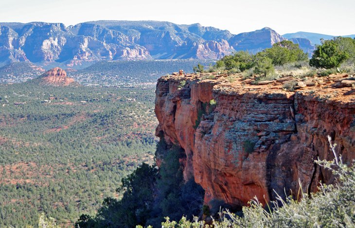
Cathedral Rock, Sedona
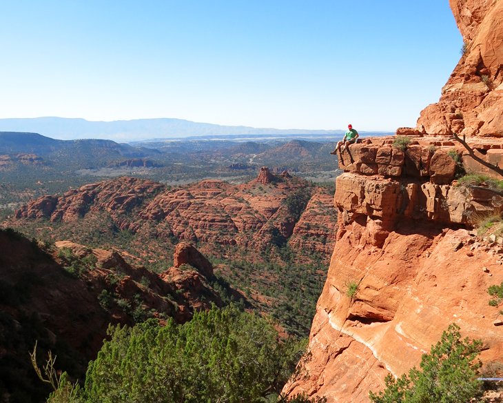
Cathedral Rock is the predominant landmark feature in Sedona and just begs to be hiked. It's also the site of one of Sedona's famed energy vortexes.
While many people head down to the shores of Oak Creek to enjoy gazing up at the towering stone monument, hikers can journey up the trail to a saddle on Cathedral Rock for a spectacular hike and wonderful views.
The hike is fairly steep in some sections and will require scrambling on hands and feet in a couple of spots. This in-and-out hike is approximately one mile in length.
For a more complete list of hikes in this area, see our article on the best hikes in Sedona.
If you want a little more adventure, Sedona's mountain biking trails are some of the best in Arizona. They range from easy rides in the desert around the rock formations to cliffside trails high above the town.
This hiking trail is serviced by the new Sedona Shuttle. During shuttle operating hours (7:30am to 5:30pm), the small parking lot is closed to private vehicles; the only way to access the hike is via the shuttle service.
Read More:
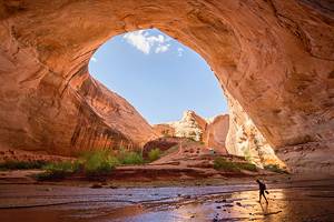
Antelope Canyon
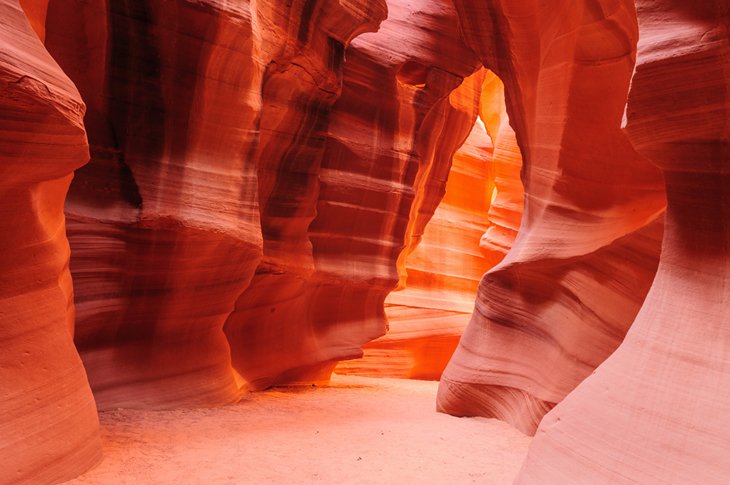
Another short but spectacular walk in Arizona is the much photographed, Antelope Canyon. This slot canyon, with narrow twisting walls that allow shafts of light to penetrate through from high above, is a photographer's dream destination.
You need to take a tour to get here, but the process is incredibly simple. It's only a short ride out to the opening of the slot canyon, where you can wander through the canyon and back at your own pace, with a guide along for safety.
The walk through the slot canyon and back is only a half-mile, and the ground is flat.
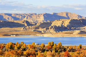
Antelope Canyon is located near the town of Page in Northern Arizona.
The Wave
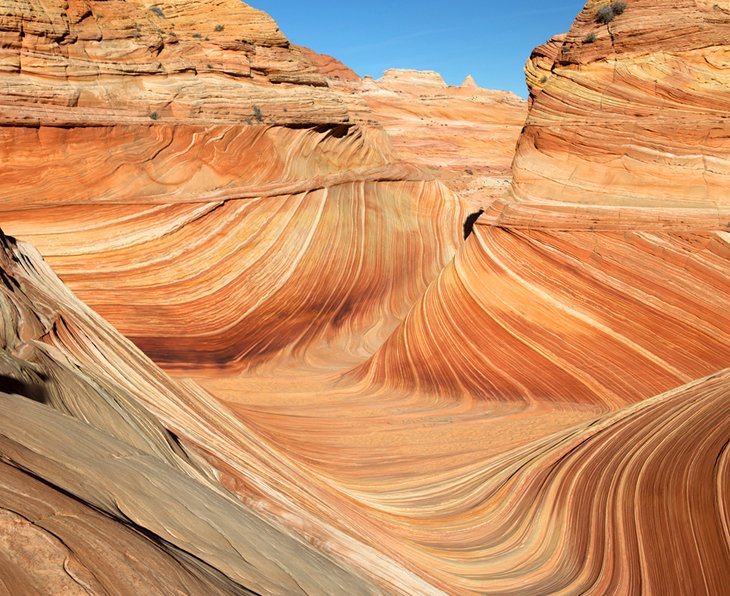
If you've wandered through a photo gallery in Arizona, in addition to having seen shots of Antelope Canyon, you've probably also noticed photos of the Wave, a swirling orange sandstone landscape that looks like a stone wave. This natural feature is found in Paria Canyon, which contains the Coyote Buttes Special Management Area.
While the Wave is the most famous hike here, you can find a number of other great hikes in this area as well.
To hike to the Wave, which is a modest 5.5-mile day hike, you need a special permit for Coyote Buttes North, and it can be very difficult to obtain due to the lottery system and the reduced number of visitors they allow into the area each day. You can apply for a permit four months in advance or if you are in the area, you can try for a daily permit.
Daily permit applications are "geofenced," meaning that you must be in the stated geographical area to apply using a location enabled mobile device. This is a dramatic improvement to the former walk-in system that saw people milling about at park offices hoping to get a hiking permit.
No motorized vehicles are allowed in the area, including drones.
Lava Flow Trail, Sunset Crater Volcano National Monument
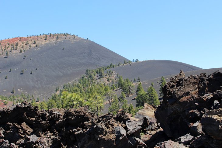
While this hike is only one mile in length, the landscape here is so interesting and unique that it is worth going out of your way to see and do. This is the youngest volcanic area in Arizona, and the landscape here ranges from barren, jagged lava flows to a sparsely pine-covered cinder cone, and more.
Once you've done the Lava Flow Trail, you can tackle other longer hikes in the monument, but don't miss out on this simple and easily trail. From the parking lot, several short paved trails loop around near the base of the huge cinder cone, but be sure to take the outermost loop, which leads off the paved trail, to see all the sites.
You can see the remains of a collapsed lava tube that meanders through a field and walk along the bottom edge of the cinder cone. If you are up for a longer hike, once you are done here, you can also hike up to the rim of a cinder cone.
Sunset Crater Volcano National Monument is also one of the top attractions near Flagstaff, and many people visit even if they are not interested in hiking.
Seven Falls Trail, Tucson
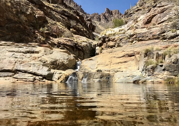
The Seven Falls hike near Tucson features a natural crystal-clear pool fed by a waterfall emanating from a mountain stream, just perfect for swimming on a hot day.
The trail winds its way gently up Bear Canyon following the stream, which you will cross several times along the way, past saguaro, barrel, and buckhorn cholla cactuses.
The trail varies in length from five to nine miles, depending on whether you choose to take the shuttle to and from the trailhead. The total elevation gain for Seven Falls is 720 to 900 feet.
This is just one of many great hikes around Tucson.
Read More: Attractions in Tucson, Arizona
Watson Lake Loop Trail, Prescott
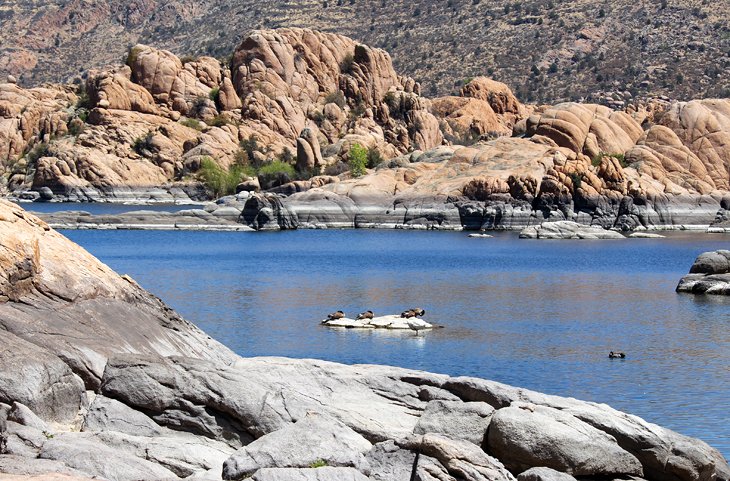
The scenic centerpiece of Prescott, beautiful Watson Lake is mesmerizing, and the Watson Lake Loop Trail provides outstanding views of the deep blue water, the granite walls that surround the lake, and the boulder-strewn islands that rise up in the center.
This 4.7-mile hike is one of the top things to do in Prescott. It takes you up to great vantage points and high lookouts, as well as along the shores and through the tumbling rock landscape.
The hike leaves from Watson Lake Park, right off the highway and within easy reach of downtown Prescott. If you have time for more than a single hike, you'll find many wonderful hiking trails around Prescott.
Read More: Campgrounds in Prescott
Doe Mountain Trail, Sedona
Sedona has so many beautiful hikes, it's hard to select a single top hike. For a short, scenic, and mildly strenuous hike, Doe Mountain is a great choice. This hike is accessible year-round, offers great views, and gives you a chance to stand on top of a mesa.
This is one of the best hikes in the Sedona area for effort expended versus enjoyment gained. It's also a fun family hike where, once you've made the ascent, you can explore as much or as little as you want on the level ground. The round-trip distance is 1.5 miles.
The trail climbs up a series of switchbacks and pops you out onto the flat top of Doe Mountain, where you can explore this island in the sky. You can often see rabbits and other wildlife up here. From the rim of the mesa, you can see off into the distance in several directions to the surrounding mountains and forest below.
Doe Mountain Trail also sees far fewer people than some of the more well-known and easier trails. And, at the top, since there is plenty of room along the rim, you can always find a space to yourself to sit and appreciate the landscape.
This hike is just a short distance from West Sedona, near the luxury Enchantment Resort.
This trail is not currently serviced by the Sedona Hiker's Shuttle; parking is usually quite plentiful.
Echo Trail on Camelback Mountain, Phoenix
This Phoenix hike is more famous than enjoyable and is included here for the sake of its reputation. It's so popular in fact, that a full-time ranger is stationed at the bottom of the hike to talk to new hikers about the obstacles and dangers.
This 2.5-mile hike takes you up to a lookout point on Camelback Mountain in the heart of Scottsdale. Views are definitely incredible, but you will work to get there as you climb 1,300 feet in just over 1.2 miles.
The first third of the hike is very reasonable, with no excessively difficult sections. Beyond here is a long set of stairs, followed by steep rock sections. Although handrails run up the most difficult areas, they're almost a necessity due to the angle of the climb.
In reality, most hikers run into difficulties by getting lost or going off the trail and then falling, or from heat exhaustion. This hike often sees more rescues per year than any other hike in a metropolitan area in the United States.
A couple of the top resorts in Phoenix back onto Camelback Mountain.
Tom's Thumb Trail, Phoenix
One of the more enjoyable hikes in the Phoenix area is the Tom's Thumb Trail in the McDowell Sonoran Conservancy.
Looking more like a granite sail perched on top of a boulder-strewn mountain, you can see Tom's Thumb from the trailhead. It looks a long way off and up from here, but the total distance for this hike, out and back, is 4.2 miles.
Locals love this trail, and the views from the top will tell you why. The trail is in the open sun, so on warm days, you should tackle it early in the day.
Devil's Bridge Trail
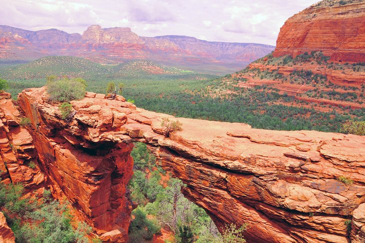
This trail, the most popular trail in Sedona by far, is nice but very busy. Before you embark, give some serious thought to other trails in the Sedona area. Firstly, the Devil's Bridge trail is not overly scenic until the very end. Secondly, half the 4.2-mile return trip is on a sun-blasted jeep trail shared with mountain bikers, jeeps, ATVs, and lots of other people.
However, all that said, the arch at the end is quite spectacular, and if you've never seen one before, it's worth checking out. You can capture interesting photos from the base of the natural bridge, but if you have a bit of extra energy and no fear of heights, the top of the bridge can be walked on, although it's not advised for obvious reasons.
To get the iconic shot of Devil's Bridge with the red rocks in behind, you'll have to hike up even more; the trail is well worn and easy to find.
To avoid the crush of people, and the somewhat boring walk, consider starting at the Chuckwagon trailhead. This way, you'll traverse rolling hills as you walk through small bushes and trees. Be sure not to miss the key turn off – study the map at the trailhead and snap a picture of it with your phone.
This route is serviced by the new and free Sedona Hiker's Shuttle, which will drop you off at the more scenic Chuckwagon Trailhead.
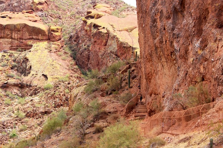
Flatiron Summit
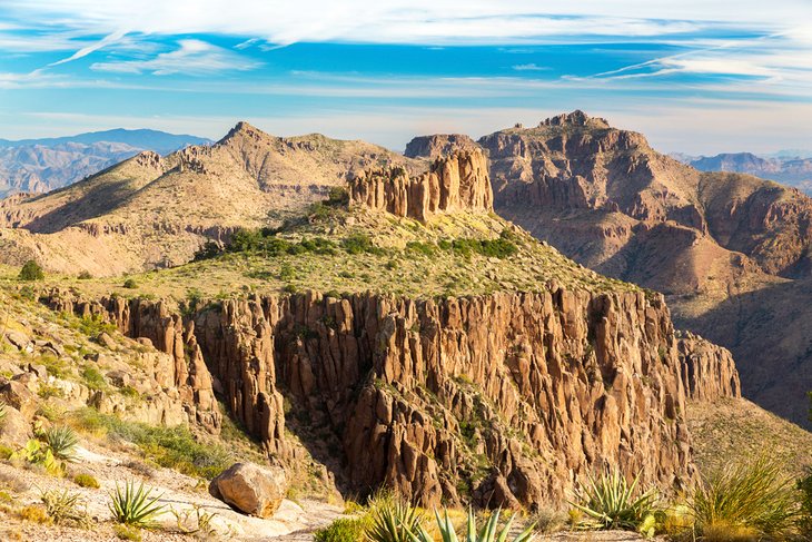
If you feel the need to bag a summit while hiking in Arizona, one of the best is located a short drive from Phoenix. Get up early and hit the trail before it gets too hot. Time it right, and you can summit and be back poolside crowing about your accomplishment by 2pm.
All joking aside, this is a serious trail for experienced hikers only. It's 6.2 miles return with a heart-pounding elevation gain of nearly 3,000 feet. At the top, a bit of scrambling can make things a bit hairy. But the view, and bragging rights, are worth the effort. Stupendous 360-degree views out over the Superstition mountains, Phoenix, and the Valley of the Sun are Insta-worthy.
The trail can be a bit tricky to follow – just look for blue dots on rocks along the way, and if you haven't seen any for a while, backtrack the way you came. At the start, you may be lulled into a false sense of confidence. The trail is flat and pretty easy; however, before long it starts to ascend, and all bets are off!
Flatiron Summit Trail is located in Lost Dutchman State Park. Be prepared to pay a nominal fee to enter.
Map of Hiking Trails in Arizona
Places to Visit and Hike in the Southwest
Hiking in Utah: Once you've explored the hiking trails in Arizona, it's probably time to head into Utah for a chance to experience some epic hikes in Zion National Park, or the best hikes in Bryce Canyon National Park, two of Utah's best hiking areas. To escape the crowds and discover some easy and fascinating hiking trails that you've probably never heard of, have a look at hiking near St. George, Utah.
Places to Visit: If you are planning a trip through Arizona, be sure to start with our article on the Attractions and Places to Visit in Arizona to point you in the right direction. Also, don't miss out on the neighboring attractions of Utah.