The USA's 15 Most Iconic Attractions And Destinations Worth Visiting At Least Once

Depending on your route, driving from the East Coast to the West Coast of the U.S. can stretch between 2,500 to 3,500 miles, which is just the first clue that the country, in its enormity, is chock-full of spectacular scenery. It contains a veritable trove of attractions and landscapes, from the Rocky Mountains, to Hawaii's pristine beaches, to Washington, D.C.'s iconic landmarks. Famous destinations like Times Square have been described as "America's worst tourist trap" with constant crowds, but a first-time visit to New York City would be incomplete without at least a glimpse.
Because the U.S. is so expansive — its entire land mass, including Alaska and Hawaii, spanning roughly 3.8 million square miles — visitors usually pick just one region to explore. Be it Florida's beaches, the temperate rainforests of the Pacific Northwest, or the high desert of New Mexico, you really can't go wrong. Whether you're an avid hiker, a beach bum, a history fiend, or a hybrid of them all, you'll find something to enjoy at the 15 most iconic destinations in the country. While all are worth visiting at least once, many will leave you longing to return again and again.
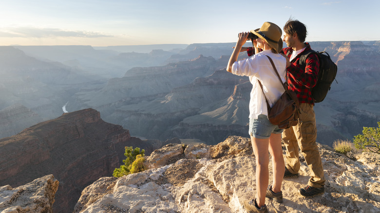
The Grand Canyon
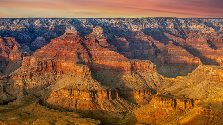
The Grand Canyon is among the most recognizable and beloved national parks in the U.S. Not only is it unequivocally gorgeous, the geological wonder also provides a unique glimpse of Earth's past, with some ancient rock formations dating back 1.8 billion years. One of the easiest and most enjoyable walks is the South Rim's Trail of Time, a paved path that stretches for exactly 2.83 miles, each meter representing one million years of the region's history. Numerous outlooks offer astonishing views, and areas like Market Square and Desert View feature shops, visitor centers, and restaurants. The North Rim is also a less-crowded destination for a more laid-back experience.
The Grand Canyon's campgrounds are large and spacious. Alternatively, the park is home to a number of historic lodges. Located in Grand Canyon Village, the Hopi House is a unique stone building that houses a shop of Native American fine arts and handmade crafts. Also in the village is the Grand Canyon Railway, with daily trips from Williams, Arizona.
Statue of Liberty and Ellis Island
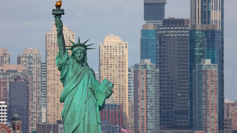
Arugably the most iconic landmark in the U.S., the Statue of Liberty National Monument greets ships in New York Harbor from her own island. The monument was completed in 1884, a gift from France to the U.S., and erected in 1886. For over 12 million immigrants who arrived in the U.S. via Ellis Island between 1892 and 1954, the statue lived up to its intent as an enduring symbol of freedom. Today, the National Park System stewards both the Statue of Liberty National Monument and Ellis Island, offering regular round-trip ferries from Battery Park via Statue City Cruises.
Ferry tickets are required to visit and include entry to both the Statue of Liberty Museum and the Ellis Island Museum, where you can explore interactive exhibits about the immigrant experience and even stop into the Family History Center to trace ancestral records. Visit Lady Liberty's colossal stone pedestal and ascend 162 steps into the crown for amazing views — keep in mind that advanced reservations are required. Guided park ranger tours are also offered at the site.
Niagara Falls
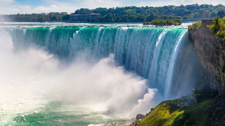
An unofficial wonder of the world, Niagara Falls is a unique and awe-inspiring natural phenomenon located within America's oldest state park. The falls encompass several cascades along the Niagara River, together marking the boundary between the U.S. and Canada. The largest is Horseshoe Falls, and the two others are called American Falls and Bridal Veil Falls. Every second, more than 3,100 tons of water spills over the drop — that's around 700,000 gallons — making it the largest on the continent in terms of volume.
Take in the falls from a variety of viewpoints, including the Ontario side. Embark on the White Water Walk, a scenic stroll on Niagara Falls' great gorge along one of North America's most dramatic rivers. Don a poncho and hop aboard a Niagara City Cruise, explore behind the falls, see the views from above in a helicopter, or climb the Skylon Tower in the city of Niagara Falls for a remarkable panoramic vista.
Walt Disney World Resort

Aside from its beautiful beaches, historic towns, and bustling cities, one of Florida's most famous draws is Walt Disney World Resort. Opened in 1971, the huge theme park outdid California's earlier iteration, Disneyland, in size and scope — more than five decades later, it continues to awe visitors of all ages. Disney World is a bucket list destination for many, whether you grew up watching Walt Disney films or are just a big fan of epic theme park rides. Just make sure to plan ahead so you're not surprised by all the hidden costs people forget to factor into a Disney World trip.
Walt Disney World is located near Orlando, and it actually comprises a number of different theme parks, including Magic Kingdom, Epcot, Disney's Animal Kingdom, two waterparks, and more. There are numerous restaurants, theaters, stores, accommodation options, and experiences to choose from. Orlando is also home to Universal Orlando Resort, Seaworld, LEGOLAND, and several beaches within an hour's drive.
Boston's Freedom Trail
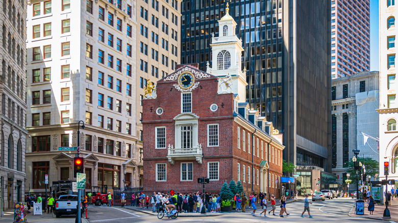
From Boston Common — America's first public park — to the Old State House, the centuries-old places along the Boston Freedom Trail invite you on a journey through American history. Sites dating back to the 1700s provide a glimpse into the era of the American Revolution. Visit the house of Paul Revere, the man famous for his "midnight ride" in 1775 to warn that the British were coming. You can also stop by the Old North Church, where a pair of lanterns were hung as a covert signal that British troops were advancing toward Boston.
The Boston Freedom Trail covers 2.5 miles and connects a total of 16 sites on a continuous red line. Visit burial grounds, meeting halls, churches, and sites of crucial events like the Boston Massacre. You can also check out the USS "Constitution," a warship that set sail in 1797 and is remarkably still afloat. Tours led by costumed interpreters depart daily from Faneuil Hall Marketplace and the Boston Common Visitor Center. You can even book a private historical pub crawl.
The Las Vegas Strip
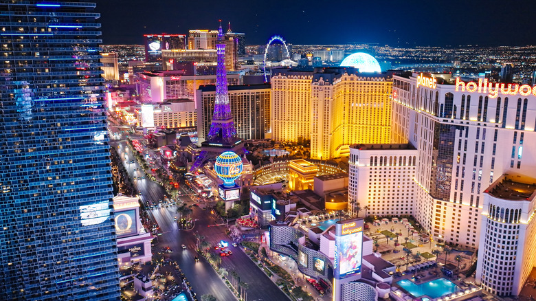
When it comes to iconic American thoroughfares, there are plenty that come to mind, from Pennsylvania Avenue in Washington, D.C. to Rodeo Drive in Los Angeles. Then there's the Las Vegas Strip. Established in 1941 with its first casino, the El Rancho Vegas resort, followed closely by the Flamingo and other large complexes, the burgeoning Strip became a hot spot for mobsters and Hollywood celebrities alike.
Today, the Las Vegas Strip — technically Las Vegas Boulevard — is lined with an array of colossal casino hotels and eye-catching landmarks. You'll see the Luxor Hotel's iconic pyramid, the dancing fountains of the Bellagio Resort & Casino, miniature Italian landmarks at The Venetian, and much more. The Strip is like a theme park for adults, complete with casinos, restaurants, theaters, and yes, even rollercoasters. Live entertainment is one of the city's biggest draws, featuring long-running productions like Cirque du Soleil, concerts, magic shows, comedy acts, and high-tech displays at the immersive Sphere.
Yosemite National Park
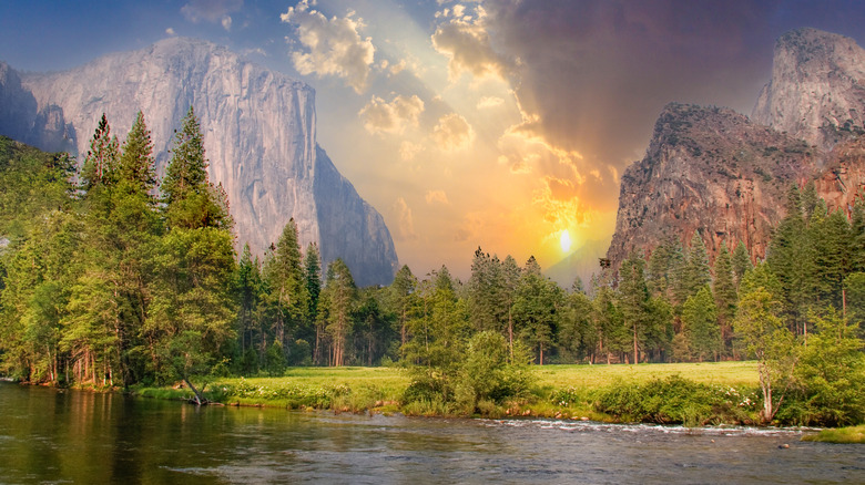
In a landscape made famous through the writings of John Muir and photographs of Ansel Adams, Yosemite National Park is a must-see for its iconic mountains, waterfalls, and lakes. Located in California's Sierra Nevada Mountains, it's about a four-hour drive due east of San Francisco. The so-called "Riviera of the Sierra" is a best-kept secret beachy haven, while El Capitan and Half Dome are on expert rock climbers' bucket lists. The park is also home to numerous dramatic cascades. Yosemite Falls is one of the park's main attractions and one of the world's tallest waterfalls, plunging more than 2,200 feet over a granite precipice. Others include the Sentinal Falls and Horsetail Fall, the latter of which famously lights up like a stream of fire as the sun sets in February.
Hiking is incredibly popular, as the park features more than 750 miles of trails through its wilderness area. If you plan to camp, especially between April and October, plan well in advance and reserve early, as sites book up very quickly. Those seeking creature comforts can book a number of lodges, and Yosemite also features glamping experiences and backcountry campsites perfect for those who love an off-grid adventure.
The Golden Gate Bridge
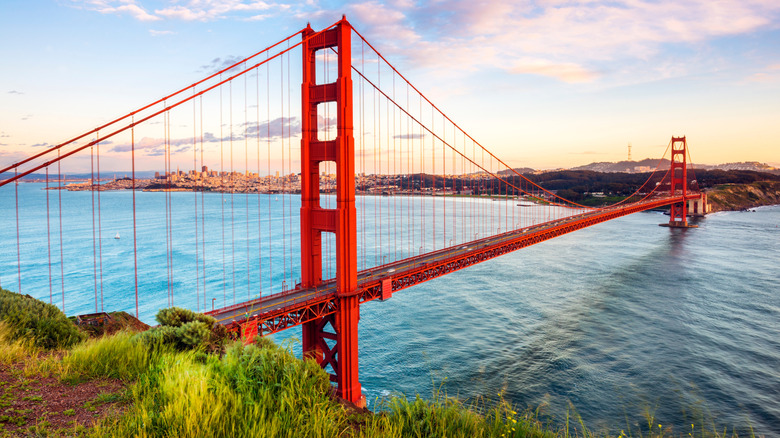
One of the most recognizable landmarks of the West Coast, the Golden Gate Bridge is a marvel of engineering. A bright red, 1.7-mile suspension bridge constructed over the course of four years, the Art Deco jewel of San Francisco Bay opened in 1937 and features towers that rise up to 746 feet from the water. The bridge is also a busy traffic crossing that welcomes close to 40 million vehicles every year. It can also be accessed on foot — a wide pedestrian sidewalk offers stunning, up-close views of the structure and the bay beyond. If you cross by car, electronic tolls are automatically collected for those heading southbound into San Francisco, with a standard fee of $10.75, as of this writing.
Beyond traversing the bridge itself, head to a number of viewpoints for amazing photo ops. Golden Gate Overlook is exactly what it sounds like, with trails through natural surroundings. Baker Beach is a popular spot for beautiful views of the bridge, and Fort Point National Historic Site sits directly beneath the structure, offering an amazing glimpse at its colossal underside.
Times Square

Thanks to its sensational New Year's Eve celebration, Broadway theaters, and flashing lights on the world's largest digital billboard, Times Square is an iconic attraction in Manhattan. While there are tourist traps to avoid in Times Square, like overpriced chain restaurants and counterfeit luxury goods, there's plenty to make a visit here worthwhile — especially if it's your first time to New York City. Visit the Museum of Broadway to discover the history of the city's renowned theater scene, catch a show nearby, or simply take it all in from the Red Steps. If you crave a moment in the spotlight, book a time slot on a billboard to share your own photo or video. The billboards in Times Square are sometimes referred to as "spectaculars," a nod to the original electric signage that used hundreds of lightbulbs to illuminate messages.
One treat for night owls is a program called Midnight Moment, a public art initiative that has been running continuously since 2012. Every night except New Year's Eve, 92 displays present a synchronized artwork starting at 11:57 p.m. sharp. The display is commissioned by acclaimed international artists, and the artwork changes each month.
The Alamo
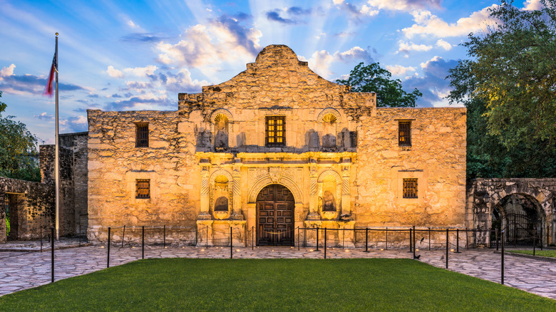
If there's a symbol for the state of Texas beyond its five-pointed star, cowboys, and epic barbecue, it would be The Alamo. Located in San Antonio, the preserved former mission commemorates the location of the Battle of the Alamo. Taking place over nearly two weeks in 1836, when much of the yet-to-be state was still claimed by Mexico, the battle pitted 200 Texas volunteer soldiers against a Mexican army thousands strong. Davy Crockett, the legendary frontiersman and former congressman, was also there, which drew even more attention to the battle. Although the Alamo eventually fell to Mexican forces, the event gave rise to the war cry, "Remember the Alamo!" The phrase endured and galvanized soldiers during the Mexican-American War ten years later.
Today, the site offers a guided tour called "Remember the Alamo," which includes access to a special exhibit and admission to the Alamo Church. A self-guided audio tour is a great way to explore the site at your own pace. Most experiences are ticketed, ranging from $10 to $48 for adults, at the time of writing. Entry to the church only is free, but you'll still need to book your visit. San Antonio also participates in the CityPASS program, which offers discounted entry to The Alamo and can be combined with other attractions like the San Antonio Botanical Garden and the Witte Museum.
The St. Louis Arch
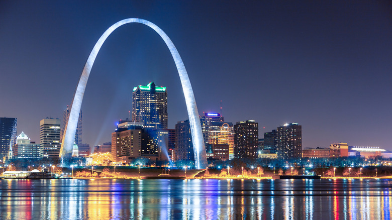
The St. Louis Arch is an icon of the Midwest and a symbolic gateway to the Western United States. Formally called the Gateway Arch, this instantly-recognizable landmark stands like a sentry over the Mississippi River. Designed by acclaimed architect Eero Saarinen, its streamlined shape is 630 feet tall and can be seen from a variety of vantage points around the city. Take a riverboat cruise to see the icon from the water, take a tram ride to the top, or visit the museum beneath the arch to delve into the region's history.
Right next to Gateway Arch is one of St. Louis' oldest existing buildings, the Old Courthouse, which also sits in Gateway Arch National Park — a pleasant area to stroll around before exploring more parts of downtown. For an upscale viewing experience with tasty nibbles to boot, book a table at Ruth's Chris St. Louis steakhouse, which boasts unobstructed vistas of the arch.
Mount Rushmore and the Crazy Horse Memorial
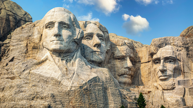
If you find yourself in South Dakota — home to Badlands National Park, one of America's best road trip destinations — head a little farther northwest to see a legendary attraction carved into the side of a mountain in the Black Hills region. Mount Rushmore National Memorial features the giant portraits of four U.S. presidents: George Washington, Thomas Jefferson, Theodore Roosevelt, and Abraham Lincoln. The monumental carving was designed by sculptor Gutzon Borglum, and hundreds of people, including his son Lincoln, worked to complete it between 1927 and 1941. The park can get very crowded in the summer, so plan to visit early in the day.
Another immense mountain monument stands just a few miles away: the Crazy Horse Memorial. Built by sculptor Korczak Ziolkowski, this tribute was started in 1948, and the carving process continues today, honoring the famed Lakota war chief. A group of museums and galleries are located at Crazy Horse Memorial, each one inviting visitors to learn about the heritage, culture, and history of Indigenous tribes in America.
Yellowstone National Park
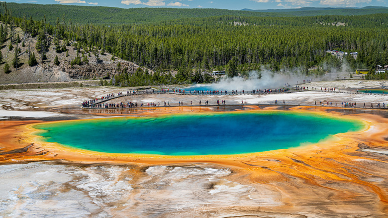
Yellowstone National Park is an immanently popular Rocky Mountain destination that also holds the distinction of being the first national park established in the U.S. It comprises 2.2 million acres of mountains, waterfalls, geothermal features, forest, and more. There are around 500 geysers in the park, but only six of these — including the "Old Faithful" Geyser — can be predicted with any regularity. Wander around the boardwalks and witness nature's show as the geyser erupts into a cloud of billowing steam.
Other attractions in Yellowstone include historic Fort Yellowstone and a number of hot springs with colorful mineral deposits, like Grand Prismatic Spring. Like many of the country's busiest national parks, it's essential to reserve a campsite well in advance if you plan to park your RV or pitch a tent. You'll also find nine lodges, inns, and cabins that offer a range of amenities.
The National Mall

The National Mall in Washington, D.C., affectionately known as "America's Front Yard," is a giant open-air museum that's free to visit. The National Mall is home to an astonishing number of nationally significant memorials and museums, including Constitution Gardens with its cherry blossoms in the spring, the 555-foot-tall obelisk of the Washington Monument, the Lincoln Memorial, and poignant memorials for World War I, World War II, and the Korean and Vietnam Wars, among other landmarks.
Visit the Ford's Theatre National Historic Site, the location of President Abraham Lincoln's assassination in 1865, or explore 11 of the Smithsonian's 21 museums. The museums, which include the American History Museum, Natural History Museum, African American History and Culture Museum, the Hirschhorn Museum, and more, are open every day of the year except for Christmas, and admission is always free.
New Orleans' French Quarter
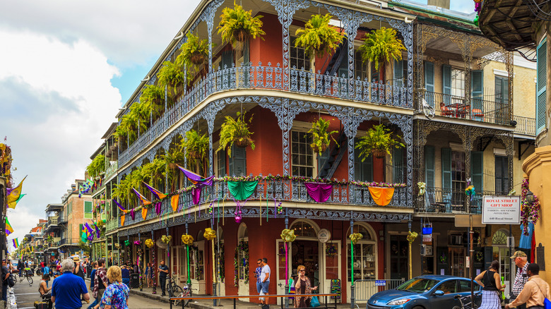
We usually hear about New Orleans' incredible French Quarter when Mardi Gras takes over the city with more than a week of festivities. But the rest of the year, New Orleans' historic French Quarter — which earned its name after a French-Canadian naval officer established the area as an urban grid system in 1718 — is still a wonderfully atmospheric place. Architecture enthusiasts will love peering at tall shuttered windows, wrought iron balconies, and quaint courtyards. Foodies will rejoice with regional specialties like po' boys — sub-like sandwiches made with French rolls and usually filled with shrimp or roast beef — gumbo, jambalaya, and beignets.
Bourbon Street is one of the most well-known thoroughfares, the epicenter of parades and nightlife. For a true taste of New Orleans, head to Lafitte's Blacksmith Shop Bar in a historic Creole cottage. Another experience not to be missed in New Orleans is live jazz, which you can soak up any night of the week at Fritzel's Jazz Club, a fixture of Bourbon Street since 1969.
Methodology
Narrowing down the 15 top spots in the U.S. for a first-time visit is no small task. For this guide, I drew from my own experiences as well as countless reviews and ratings from visitors on sites like Tripadvisor and Google. For additional recommendations, I used various tourism boards as a resource, including NiagaraFallsTourism.com, VisitOrlando.com, Vegas.com, TravelSouthDakota.com, and NewOrleans.com.
For location-specific information such as on-site attractions, admission fees, and opening hours, verified resources such as the TheFreedomTrail.org, GoldenGate.org, TheAlamo.org, GatewayArch.com, and FrenchQuarter.com were used. Additional historical context and information was sourced from History.com, Frommers.com, NPS.gov, and ParksConservancy.org.