11 Top-Tier USA Tourist Attractions First-Time Visitors Should Never Skip
With big cities, spectacular natural landscapes that range from deserts to lush forests, tons of diversity, and world-renowned sites that are bucket list items on everyone's must-visit list, there's something for everyone to see in the United States. More than 70 million people visit the country every year, making America the third most popular tourist destination on the planet. But with so much to see in 50 states (plus Washington D.C.) — which span 3.8 million miles, making it one of the biggest countries in the world — how do you even begin to go about planning your itinerary?
PlanetWare rounded up some of the best tourist attractions in the United States so you can head home at the end of your trip satisfied that you've experienced the best that the country has to offer. To do so, we considered which sites are the most popular, are the most renowned and famous around the world, and have the best and most reviews on Tripadvisor. But don't think this should be the end of your American getaway — on your next trip, there's even more to see.
Fisherman's Wharf, San Francisco, California
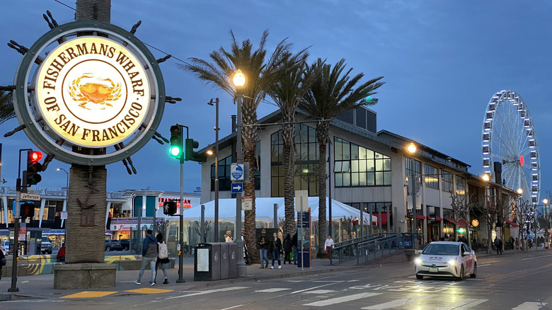
Located next to the San Francisco Bay and the Pacific Ocean, San Francisco, California, epitomizes a seaside city with its salty air wafting through the ever-present breeze. That water-loving attitude culminates in Fisherman's Wharf, which is one of the most-visited neighborhoods in the city. Although parts of it can be touristy, don't get it twisted — this neighborhood is as authentic as it gets, dating back to when Italian fishermen patrolled the waters during the Gold Rush.
Today, the third generation of fishermen can be seen right from the wharf's piers, supplying the many restaurants that call the neighborhood home. A few favorites include Scoma's, which has been an institution since 1965, as well as the Fog Harbor Fish House, which only serves sustainably-caught seafood. You'll know you're in the right place when you see the massive Fisherman's Wharf sign on a wooden ship's helm, which has been a landmark here since 1968.
Even if you're not a seafood fan, there's so much kitschy fun to be had on Fisherman's Wharf. Don't even think about leaving the neighborhood without visiting the countless sea lions that surround Pier 39. And this wouldn't be a beach hangout without a sweet, which is why Ghirardelli Chocolate has created a chocolate mecca in one of the area's plaza squares. From the wharf, you can also access iconic San Francisco spots like Alcatraz Island and Angel Island State Park, or even go whale watching.
Freedom Trail, Boston, Massachusetts
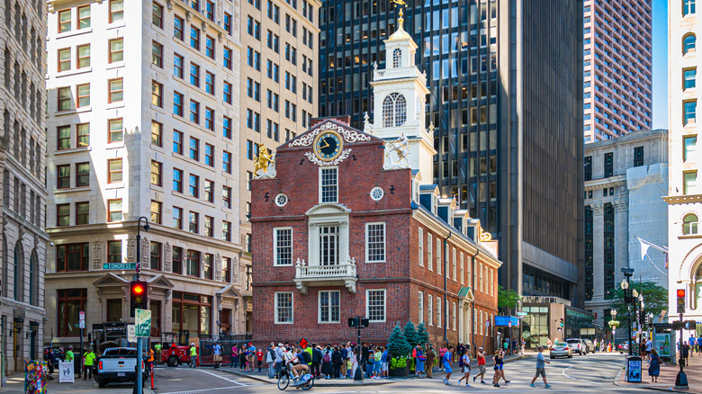
Boston is known as the home of the American Revolution and is chock-full of historic sites dating back to when the founding fathers walked what would become the United States. There's no better way to experience that than to traverse the two-and-a-half-mile Freedom Trail, which includes 16 American historical landmarks, including a cemetery where Revolutionary figures are buried and the meeting house where plans were made for the Boston Tea Party. More than four million people walk the brick-lined Freedom Trail every year.
The first stop on the trail is Boston Common, which was where British soldiers were posted prior to their march to Lexington and Concord. Long before that, the park was established as the country's oldest in 1634. Another must-visit site on the trail is the Granary Burying Ground, dating back to 1660, where 5,000 people are laid to rest. Some of the city's most important historic figures are buried here, including Paul Revere, John Hancock, and Samuel Adams.
Before doing the cheesy-but-fun tourist must of throwing bags of tea into the water at the Boston Tea Party Ships and Museum, also stop on the Freedom Trail to see the Old South Meeting House, where Boston residents gathered prior to the Boston Tea Party. History buffs should also check out the Old State House, which was where the Declaration of Independence was first read to Boston residents and where the Boston Massacre took place.
The Grand Canyon, Arizona
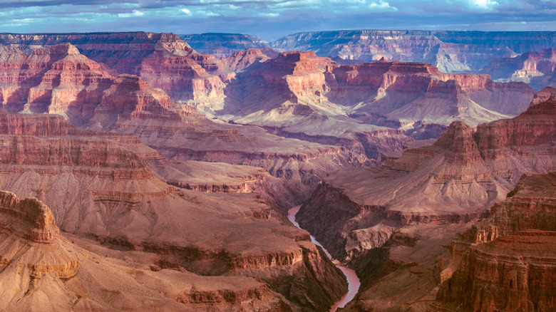
Every year, more than four million people strap on their hiking boots to explore the 277 miles that make up the Grand Canyon, which is so massive in size that it has four rims and most of the life zones present in the country. It dates back more than five million years when the Colorado River etched its way into the Colorado Plateau, eventually making it one of the Seven Wonders of the World. Even if you can't see all of the Grand Canyon during your first visit to the United States, you can still get a taste of this Arizona natural beauty that stretches one mile deep. Just a few of the activities you can choose from here include hiking, biking, camping, and embarking on a river trip. On your trip, you might spot elk, bighorn sheep, scorpions, buffalo, Gila monsters, and more.
A good hike to start your journey is the popular Rim Trail on the South Rim, which brings visitors to canyon sites such as the Yavapai Geology Museum and the Hopi House, which showcases the Indigenous architecture of the area. It also leads to the Trail of Time, which showcases the many colors of the canyon. Or, hop on the Bright Angel Trail, which traverses to the Indian Garden and a bridge over the Colorado River to offer great views of the canyon from below. If views are what you're after, then hike 85 steps up to the Desert View Watchtower.
Hollywood, Los Angeles, California
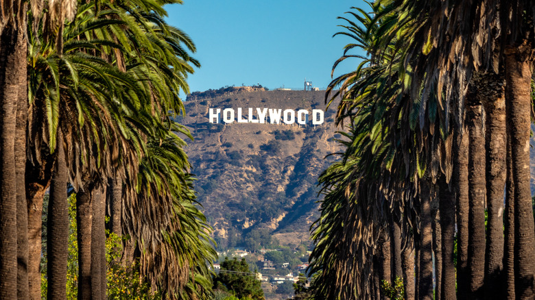
We've all watched the most famous people on the planet walk the red carpet with stars in our eyes. In Hollywood, a Los Angeles, California neighborhood that's the home of the American film industry, you can see the stars — for real. Dubbed Tinseltown, this neighborhood is where film buffs can find the Hollywood Walk of Fame, the 450-foot-long Hollywood sign on Mount Lee, working film studios, and more sites, some of which date back more than a century.
Start your journey in this glamorous neighborhood by walking the walk that the stars do — literally — at the Hollywood Walk of Fame, which has the stars of more than 2,500 famous figures stretched over 15 blocks. You can also see those stars' handprints and footprints in front of the TCL Chinese Theatre, an ornate and historic movie palace. Or head to the Dolby Theatre, which is where the stars gather for the Academy Awards every year.
To see where these entertainers actually work, take a tour through one of the many film studios that are situated in Hollywood, including Warner Bros. Studio, Paramount Pictures Studio, and Universal Studios Hollywood. On these tours, visitors can see outdoor sets, studio lots, soundstages, and relics from famous movies. You can also catch a live taping of a show at some of these studios. Although you're not guaranteed to see a real-life star on your foray in Hollywood, you can at least see their likenesses at the Hollywood Wax Museum.
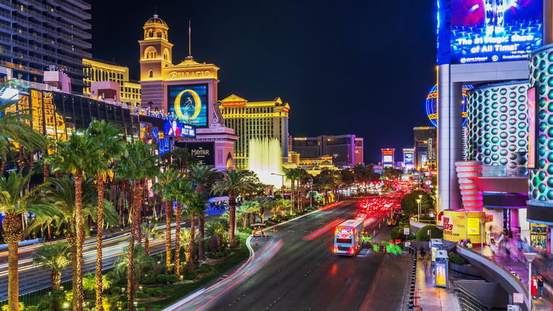
Las Vegas Strip, Las Vegas, Nevada
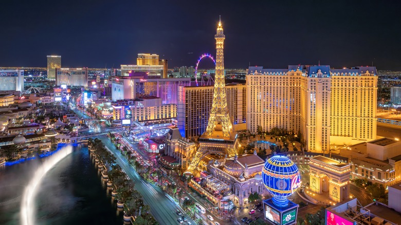
With luxurious hotels, electric clubs, five-star restaurants, and jaw-dropping shows, the Las Vegas Strip in Las Vegas, Nevada, is the ultimate adult playground. Here in Sin City, you'll run out of cash long before you run out of things to do. Even better, you can enjoy some of the city's most famous fun without leaving the four-mile Las Vegas Strip.
Start your foray through this sparkling wonderland by first deciding which of the city's 150,000 hotel rooms you'll unwind in, ranging from the celebrity-owned Cosmopolitan to Resorts World Las Vegas, which has more than 40 restaurants and bars on-site. Luxuriousness permeates many of the Strip's hotels, including the ornate Venetian, which features gold tones and grand columns, and the Bellagio, known for its over-the-top fountains that grace many postcards.
Next, figure out which spots to book for dinner — and good luck choosing them. Las Vegas is known for its renowned, high-end dining, with many restaurants run by award-winning chefs. Inside Jose Andres' Bazaar Meat, customers can dine on outlandish items like foie gras cotton candy, or they can opt for supper club-inspired Delilah's. Finally, figure out just what you would like to be wowed by before or after dinner, choosing from the Strip's array of shows and other activities. Cirque du Soleil, commanded by world-famous acrobatic performers, is a must-see, or kick back at the Buddha-shaped Awana Spa.
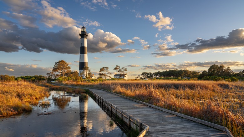
Outer Banks, North Carolina

Beach destinations can get rowdy, but not the Outer Banks, a collection of barrier islands in North Carolina. This area has maintained its historic charm and natural wonder, with so many beautiful beaches that you'll wonder how such an ethereal place has remained unspoiled. And don't worry — no matter where you stay in the Outer Banks, you'll never be far from the rolling waves of the Atlantic Ocean at either rental vacation homes or hotels. Better yet, you'll always find a spot to park your beach towel, since the beaches here aren't overcrowded like other major American beach spots.
If you're a history lover, you'll find plenty to explore in the Outer Banks. Whalehead, an American Art Nouveau-style home in Historic Corolla Park, was built in the 1920s for a railroad magnate's son, while the nearby Currituck Beach Lighthouse has been beckoning ships to land since 1875.
Unlike many other beach destinations, Mother Nature's wonder is still on display in the Outer Banks, especially on Carova Beach in Corolla. Here, wild Spanish mustangs run free. Or, go bird watching through the nearly dozen acres of Duck Town Park before seeing the tallest natural sand dunes on the East Coast at Jockey's Ridge State Park. You can also just kick back at Cape Hatteras National Seashore, an Outer Banks beach that's a yearly favorite for family vacations.
Pike Place Market, Seattle, Washington
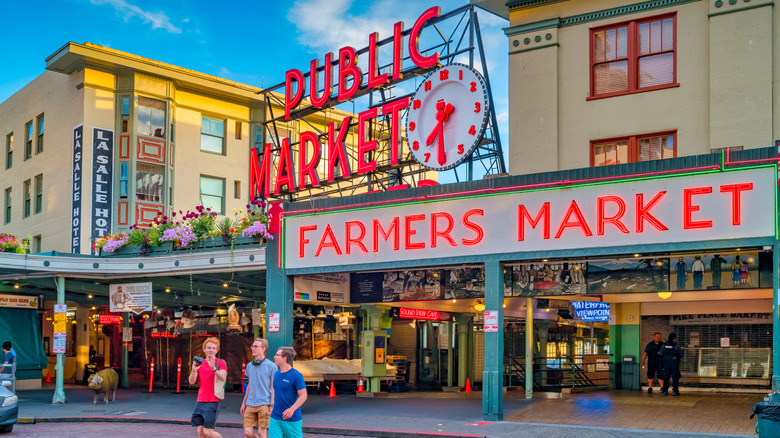
If you're a foodie, then there's no place in America like the Pike Place Market in Seattle, Washington, which is the oldest and biggest public market in the country, as well as one of the tourist traps in America that is actually worth visiting. Housing more than 500 shops, vendors, and restaurants, it's been an epicurean epicenter since 1907, when it was established as a solution to a food pricing crisis. It quickly became a popular spot and grew exponentially, and even evolved to become Seattle's most-visited tourist site, drawing 10 million people annually. Plus, it's almost guaranteed to be open during your Seattle visit, as it only closes on Thanksgiving and Christmas.
Even though the market is situated on the seafood-rich Puget Sound, there's plenty to eat here besides seafood. Tons of international vendors fill this culturally-rich market, including Hellenika, a Greek creamery, and Piroshky Piroshky, a Russian pastry shop. If you're looking to kick back with a cold one, you can head to spots such as Pike Brewing Company or Old Stove Brewing Co.
Those who love sweets will adore market vendors like Sweetie's Candy, which offers more than 300 candy varieties, as well as the Pike Place Bakery, which sells items ranging from doughnuts to custom cakes. To sit down to enjoy your Pike Place Market bite, head to market restaurants such as the French bistro-inspired Virginia Inn or Emmett Watson's Oyster Bar, which was the first oyster bar in Seattle.
San Antonio River Walk, San Antonio, Texas
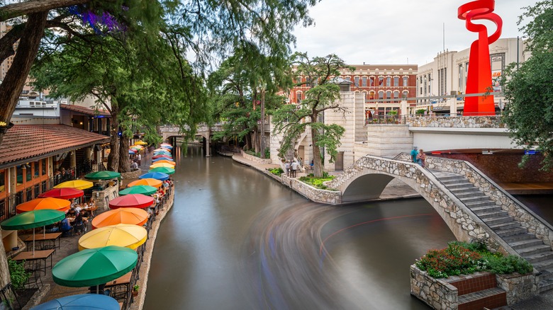
If you want to see the best that San Antonio, Texas, has to offer, don't pull out your map. Just make your way down the 15-mile San Antonio Riverwalk, which winds along the San Antonio River and features cultural institutions, restaurants, shops, and more. It's no surprise that the Riverwalk, which is as scenic as it is jam-packed, is San Antonio's most beloved tourist attraction with millions of annual visitors. Its beginnings date back to the 1940s, when it was established with inspiration from Venice, Italy.
If you want to check out the bustling Riverwalk in action, you can simply stroll its tree-lined banks (which will take five to six hours if you want to see the whole thing), take a guided tour, or take a river cruise. No matter which way you explore the Riverwalk, don't leave without experiencing the Alamo, which is the only UNESCO World Heritage Site in the state. It's where, nearly two centuries ago, just 200 Texans protected the Alamo from 2,500 Mexican troops during the Battle of the Alamo in the Texas Revolution.
Another must-do Riverwalk activity is to see a show at the Arneson River Theatre, which is as stunning as it is historic. Dating back to 1939, it's a renowned theater located uniquely on a limestone cliff and along the river. Before the show, have dinner at German restaurant Schilo's, which is the oldest restaurant in San Antonio. While here, check out these year-round Texas tourist attractions.
Times Square, New York City, New York

With 300,000 visitors every day, Times Square in New York City, New York isn't just one of the most popular tourist spots in the United States — it's one of the most popular on the planet. Throughout its five blocks that range from 42nd to 47th Street, the neon lights of the billboards and iconic buildings here are so vivid that even spaceships can see them. For decades, people have been clamoring to see them in person, from New Year's Eve when the area gets one million visitors to every day. That popularity has been budding since Times Square was dubbed as such due to The New York Times having its offices there.
Times Square is another one of those spots that you'll never get to experience all of in one visit, but you can at least start your endeavor by seeing a Broadway show. More than 40 theaters are in Times Square, offering shows for every interest and budget. Renowned shows can also be seen at Radio City Music Hall, especially during Christmastime, when New York City might as well be the North Pole. During the holiday season, the Radio City Rockettes hit the stage for one of their most iconic shows of the year. If you've spent a little too much on your seats, kick back with a slice of genuine New York pizza at John's of Times Square, which makes its pizza in 800-degree coal-fired ovens.
Walt Disney World, Orlando, Florida
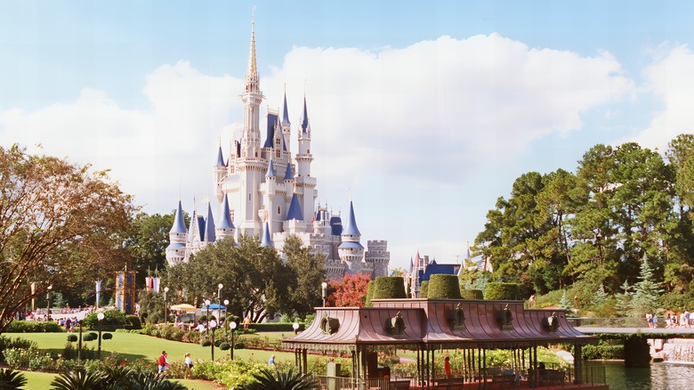
When Walt Disney announced his intent to build Walt Disney World in Orlando, Florida, in 1965, he said he was planning to build the best park on the planet — and many would argue that he did. Disney resorts now span the globe, but they all pale in comparison to the Orlando park, which is the largest Disney resort in the world by far.
Spanning 25,000 acres, it's the showpiece of the city with Magic Kingdom, Epcot, Hollywood Studios, and Animal Kingdom parks, as well as two water parks. Epcot offers around-the-world experiences for both adults and kids, while Magic Kingdom is where visitors will find classic Disney fun, such as the iconic Cinderella Castle. Meanwhile, Animal Kingdom offers authentic safari-themed experiences and rides, and Hollywood Studios has movie-themed attractions for film buffs. Plus, with many Disney-owned hotels and restaurants also on the property, a visit here can be an all-inclusive one with Disney experiences during every moment. But before you book, make sure you study these 22 Walt Disney World vacation tips and hacks that only insiders know.
Yellowstone National Park, Wyoming
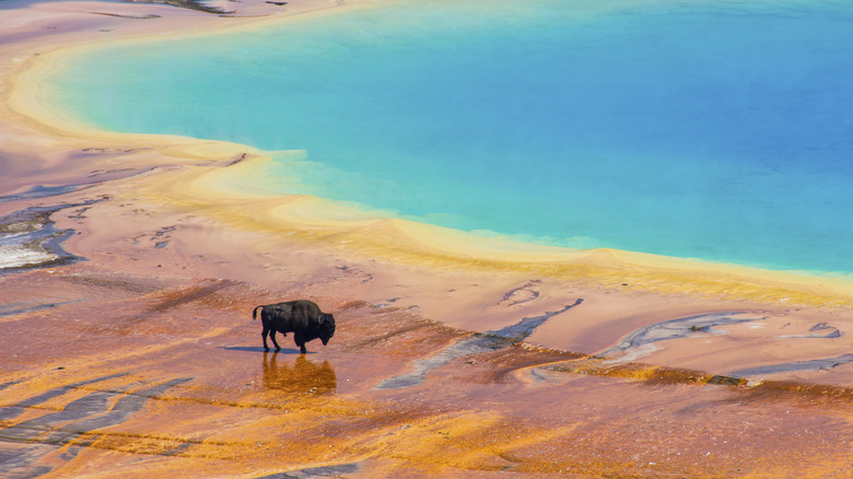
We weren't kidding when we said that the United States is home to magnificent natural landscapes. Those culminate in Yellowstone National Park in Wyoming, which was the first national park on the planet and has the most geothermal elements in one area due to magma beneath the ground. This two-million-acre park is home to some of America's most jaw-dropping wonders, including hydrothermal pools, one of the largest geyser formations on earth, a massive and colorful canyon, and hot springs. Those features make this one of the most famous national parks in the country. But don't worry, you can squeeze your visit into one day if you follow this itinerary.
One of the most renowned parts of Yellowstone National Park is Old Faithful, which spouts water 130 feet up in the air throughout the day. In its vicinity are 60% of the geysers on Earth. The park also has its own Grand Canyon, which was formed due to both volcanic eruptions and the Yellowstone River. Within the canyon is the Lower Yellowstone River Falls, a thundering, 300-foot-tall waterfall surrounded by rocks of all shades. Yellowstone National Park is also well-known for its wildlife, including bison, which can best be seen in Lamar Valley. During your visit, there are many places to stay at in or around the park.
Methodology
PlanetWare is used to rounding up the best sites to see in places like Italy, France, and the United Kingdom. But it's a lot easier to choose the best things to do in a country that's the size of one American state than the best things to do in all of the vast United States. As always, PlanetWare was up for the challenge.
To do so, we first determined which sites are the most famous around the world — those that tourists, even on the other side of the planet, are desperate to see. Then, we considered which sites get the most visitors every year. Finally, we evaluated which sites have the most and best reviews on Tripadvisor, so you can travel confident that tourists just like you have raved about their experiences.