Popular Oregon Tourist Attractions You Can't Miss On Your Next Trip
From the verdant Willamette Valley, to the Pacific Ocean's rocky coast, to the Cascade Mountains' expansive forests and peaks, Oregon's landscapes are diverse. That also means you're spoiled for choice with virtually endless options for road trips and outdoor recreation. The Beaver State is home to urban hubs like Portland, Eugene, Salem, and Bend, which boast some of the best beer, food, and culture you can find. You might also take in some of the Pacific Northwest's most beautiful water features along the "Highway of Waterfalls," a scenic road trip through a magical river valley. Or, if you head to the southeastern part of the state, hiking around Steens Mountain or Kiger Gorge.
No matter where you go, stunning natural landscapes and beautiful communities await. Whether you're a first-time visitor or frequent traveler to Oregon, don't miss these 11 fantastic attractions on your next trip.
Hike in Columbia River Gorge National Scenic Area
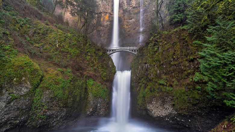
A jewel of the Pacific Northwest, the Columbia River is the largest waterway in North America to spill into the Pacific Ocean. Marking the boundary between Oregon and Washington, the river flows by Astoria, Portland, and The Dalles, one of the area's best kept secrets with wineries and scenic trails. Its canyon, known as the Columbia River Gorge, features basalt walls up to 4,000 feet high. Thanks to tens of millions of years of volcanic activity and massive Ice Age floods, we have the opportunity to visit this stunningly beautiful, 85-mile-long region that hosts the most waterfalls of any river in the world. One definitely not to be missed is Multnomah Falls, which clocks in at 620 feet high.
A popular hike around Multnomah Falls is a challenging, 5-mile loop that combines Wahkeena Trail, Larch Mountain Trail, and Return Trail, where you can take in three additional cascades: Weisendanger, Ecola, and Fairy Falls. The area can get crowded, though, so head there early for a better chance of finding parking at Wahkeena Picnic Area. Because of the terrain, most of the hikes here are challenging. For a more moderate route, check out the 2.4-mile Dry Creek Road Trail to Dry Creek Falls. And a little farther east, start at the Wyeth Trailhead at Wyeth State Park, then connect to Gorge Trail for a 4.1-mile return trip brimming with beautiful views over the river.
Wine tastings in the Willamette Valley
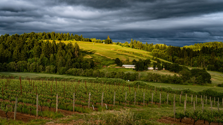
Famous for its charming covered bridges and farms growing everything from dahlias to hazelnuts to raspberries, the Willamette Valley is a lush oasis for farm-to-fork foodies. This beautiful region extends south of Portland down past Eugene, encompassing destinations like Corvallis, Oregon's vibrant "Heart of the Valley," and Salem. And it's also renowned as a wine-growing region, where two-thirds of the state's vineyards and wineries are nestled in the rolling hills. It's particularly well-known for pinot noir, but you'll find a wide array of award-winning varietals here. Take in beautiful views with a glass of red at the aptly named Willamette Valley Vineyards near Turner. A Tripadvisor Traveler's Choice recipient in 2025, the vineyard offers tastings, tours, food and wine pairings, special events, and a glorious outdoor patio.
A surefire way to experience some of the region's best wines is with a guided tour from a local company like Oregon Winemaker Tours. Carmine Campione, the outfit's proprietor, draws on more than 30 years in the winemaking industry to provide a fully customized experience with expert insights. With nearly 1,000 wineries dotting the valley, a tour can help narrow down your monumental number of choices. As of this writing, a full-day winery tour with Campione is $350 per person — including lunch —for a group minimum of two. A half-day tour is $200 per person.
Wildflowers at Crater Lake National Park

A natural wonder located high in the Cascade Mountains of southwestern Oregon, the stunningly blue Crater Lake holds the distinction of the deepest lake in the country. It formed 7,700 years ago when the volcanic peak erupted, and its collapse created a giant bowl-like impression called a caldera. Over subsequent millennia, snow and rain collected in the basin to transform into the lake we see today. Thankfully, it's protected by the National Parks Service and makes for an immanently gorgeous place to visit for a hike or a camping stay. Summer is a spectacular time to visit after the snow has melted and the park's dozens of miles of trails are easy to traverse.
Wildflowers are abundant across meadows and along trails in Crater Lake National Park, which you can see practically from the moment the snow melts in spring until it returns in winter. Due to the elevation and habitat changes within the park, a wide range of wildflowers can be found in different areas. Keep an eye out for the yellow stream violet or the frilly, red Applegate's paintbrush. Springbeauties and spreading phlox will be among some of the first botanicals to greet you in the earlier part of the season, while goldenweed and rabbitbrush grace the hillsides in the fall. For an endlessly scenic overview, don't miss the Rim Drive, a 33-mile byway that boasts 30 overlooks for taking in Crater Lake from different vantage points.
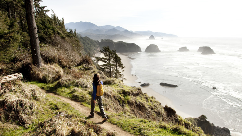
Explore Astoria and Cannon Beach
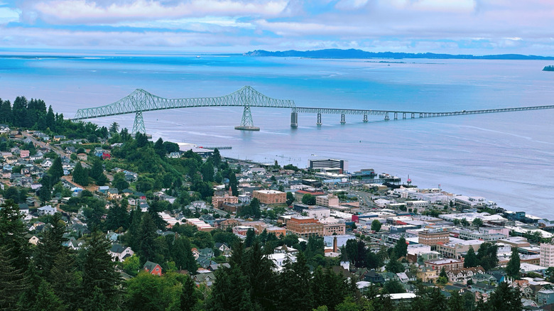
Fans of the 1985 film "The Goonies" will likely recognize the iconic settings of Astoria and Cannon Beach. The latter is home to the iconic Haystack Rock, a 45-minute drive down the coast from Astoria and a worthwhile stop on your road trip to visit all of the state's "Seven Wonders." Stop in the town of Cannon Beach for fresh-caught seafood at Anna's Table or Driftwood Restaurant & Lounge. Just north of town, en route to Astoria, pop by the stunning Ecola State Park, where you can take in the views around Tillamook Head. Here, you'll spot the offshore Tillamook Lighthouse, which was completed in 1881 and came to be known as "Terrible Tilly." It was decommissioned in 1957 because it was so treacherous to reach it.
Astoria is an architecture-lover's dream, where you can visit the historic Flavel House Museum — you might also recognize this as the historical museum featured in "The Goonies." It also happens to be one of the best-preserved Queen Anne homes in the Pacific Northwest. For even more history, don't miss a wander through the Columbia River Maritime Museum. Then, head up to Coxcomb Hill for panoramic views of Astoria and its signature feature, the 125-foot-tall Astoria Column. Inspired by the Column of Trajan, an ancient Roman masterpiece of narrative art, the Astoria version traces the area's history in a spiraling format, from pre-European Indigenous life to after the railroad was built.
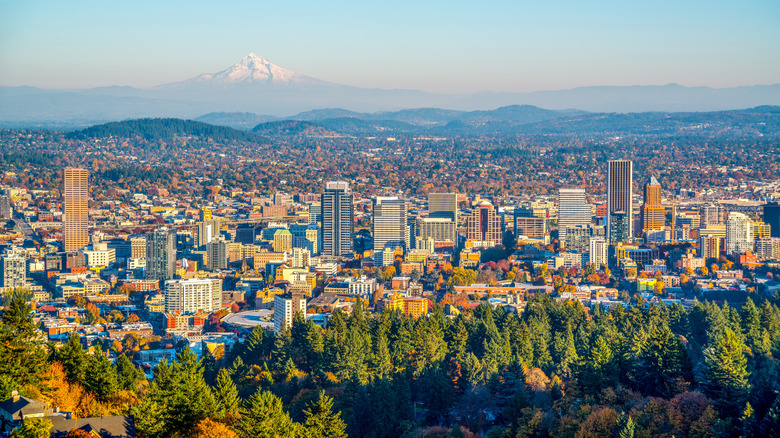
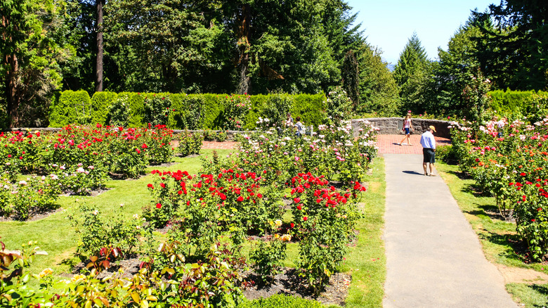
Smell the roses in Portland's gardens
Portland's got a thing for parks and green spaces. Along with its amazing craft beer scene, diverse food culture, and literary life at the largest independent bookstore in the world, the city also boasts fantastic access to nature. You can reach the Columbia River Gorge National Scenic Area in less than 30 minutes, and the Pacific Coast is only about two hours west. And don't forget its dramatic backdrop of Mt. Hood. Without even leaving the city, though, you have access to some absolutely amazing ways to get outside and smell the roses — literally.
Located in Washington Park, a sprawling green space just west of downtown, the International Rose Test Garden is a sight to behold between May and October when more than 10,000 rose bushes explode with color. Representing over 600 varieties, the garden has been delighting flower enthusiasts for longer than a century. The best part is that it's free to visit. Washington Park is also home to the Hoyt Arboretum and the Portland Japanese Garden, the latter of which covers 12.5 tranquil acres. As you explore, you'll observe different gardening approaches used through Japanese history, with art shows on display in the Pavilion Gallery. For another cross-cultural horticulture experience, head downtown to the Lan Su Chinese Garden, just two blocks west of the Willamette River.
Outdoor recreation at Mt. Hood
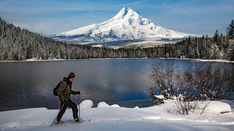
Drive only about two hours southeast from downtown Portland and you'll be transported to a completely different world. Drive through gorgeous stands of conifers and make your way to Oregon's highest point, the volcanic peak of Mt. Hood National Forest, which rises more than 11,100 feet above sea level and can be seen from miles around. The national forest encompasses more than 1 million acres and boasts 80 campgrounds, a number of ski resorts, and more than a dozen designated Sno-Parks. So no matter if you're heading to the area to enjoy hikes in the warmth of summer or have your skis in tow to glide through the glades, this is an outdoor-lover's paradise.
To mix some history with your outdoor recreation, head to the National Historic Landmark of Timberline Lodge, which features a classic mountain ski lodge built in 1937. Today, it remains a top destination in Oregon for its skiing, snowboarding, mountain biking, hiking, and its scenic summertime Magic Mile Sky Ride chairlift. If something a bit more rustic is to your taste, head toward one of the area's wooded campgrounds, like Trillium Lake Campground or Hoodview Campground, which, as you might guess, boasts glorious views of the volcano in the distance.
Ice cream in Tillamook
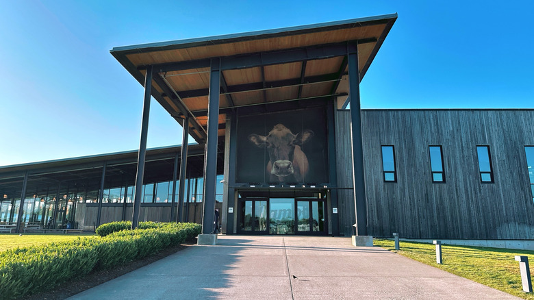
Maybe you've seen the packs of butter or cheese in your local grocery store, but a visit to the flagship Tillamook Creamery, located right on Highway 101, is worth making a trip for. Tillamook is a coastal Oregon city known for scenic kayaking and famous cheese, and you'll get right to the heart of this dairy-loving area with a stop for ice cream at the creamery's giant counter, which has an outdoor side when the weather's nice. Take a tour or sit within view of a replica of the iconic Morning Star ship, which connected Tillamook to Portland and Astoria in the mid-1900s and symbolizes the town's resilience and spirit.
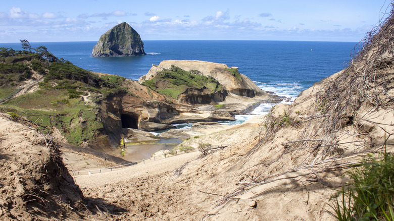
For a beachy detour from downtown Tillamook, head out to the coast for fantastic views, great food, and relaxing places to stay. Take in amazing views of the ocean from Cape Meares Lighthouse, then head to Oceanside, a hillside residential community boasting phenomenal beachcombing and numerous vacation rentals with gorgeous views of its rocky coastline. Drive 15 minutes south to see the sunset from the beach or hike miles of trails at Cape Lookout State Park, including two segments of the Oregon Coastal Trail. And just another 11 miles south of there, grab a beer at Pelican Brewery overlooking Cape Kiwanda in Pacific City, where you can sip a West Coast IPA while enjoying views of yet another monumental sea stack called Haystack Rock — not to be confused with the one in Cannon Beach — also known as Chief Kiawanda Rock.
Lava tubes at Newberry National Volcanic Monument
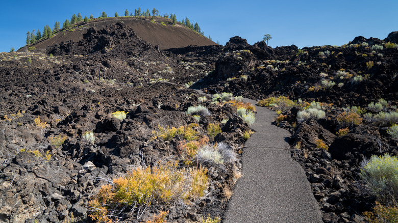
Spanning around 1,200 square miles — approximately the size of Rhode Island — Newberry Volcano is a geological wonder in the Oregon Cascades and a haven for outdoor recreation. Lace up the hiking boots and head out on miles of trails in three different parts of the park: Newberry Caldera, Lava Lands, and Lava Cast. Head to the Lava River Cave Interpretive Site, where a mile-long lava tube is yours to explore. You'll need to book a timed reservation parking ticket in advance, which requires a $2 reservation fee on top of a valid recreation pass, such as a day pass or America the Beautiful annual pass. Bring a flashlight or rent one, and explore a totally unique cave that conveys you through an ancient lava flow 55 steps below ground. It'll take you just about an hour to explore the whole thing. Just remember to bring a jacket, as it's always around 42 degrees Fahrenheit inside the rocky tunnel. Keep in mind that the cave is only open seasonally from mid-May to mid-September.
For beautiful lake views, head out on Paulina Lakeshore Loop for a relatively flat 6.9-mile trek. You'll be able to spot birds and wildlife from the trail and take a dip in natural hot springs right next to the lake. Visitors have shared on AllTrails that the hike is usually not very crowded, but the hot springs can be. And while it's dog-friendly, look out for rough or sharp patches of rock, especially around the hot springs.
Float around Bend and the Deschutes River
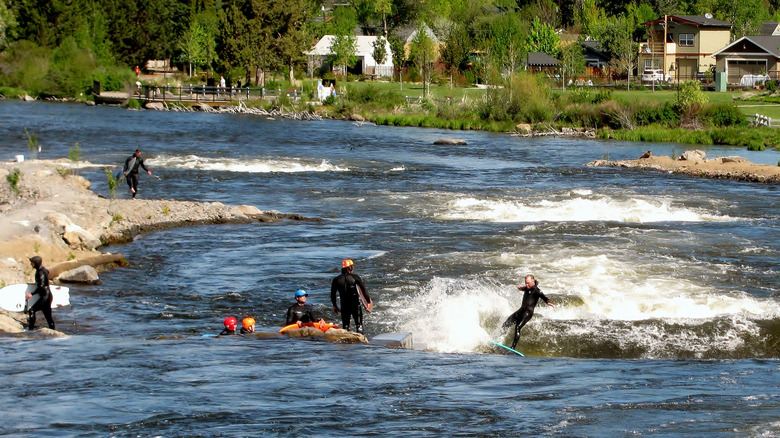
A surprisingly short drive north from Newberry National Volcanic Monument sits the welcoming college town of Bend. Craft beer, art, and outdoor adventure unite in this naturally breathtaking Oregon City, which straddles the Deschutes River on its way north to the Columbia River. In 2015, the city opened the Bend Whitewater Park on the river, not far from downtown. This haven for paddlers and urban surfers consists of three distinctive sections: the Fish Ladder, Whitewater, and Habitat channels. The Fish Ladder is a great channel for beginners, families, and casual tubers or paddlers, thanks to a gentle, sloping run with a series of drops that add excitement, but don't require advanced skills. The Whitewater channel features more intense waves enjoyed by surfers and thrill-seeking kayakers. And the Habitat channel is for wildlife only, providing a safe route for fish and fowl as they migrate up and down the river.
After floating on the Deschutes River, dry off at the High Desert Museum. This beautiful building and garden showcases Native American culture, nature, and art through both permanent and rotating exhibitions. You can even observe live animals, like the museum's three river otters: Brook, Pitch, and Wesley. The Donald M. Kerr Birds of Prey Center highlights some of the region's most amazing raptors, and staff often lead special programs where visitors can meet some of these animals face-to-face. Don't forget to explore the beautiful trails around the grounds, too.
Hike the Oregon Coast Trail
Whether you're looking for a relaxing afternoon walk or a weekend-long trek in the wilderness, the Oregon Coast Trail (OCT) has you covered. In its entirety, the OCT spans 425 miles, with a series of ferry crossings over bays and rivers along the way. It's organized into 10 sections, each encompassing about 35 to 45 miles each, so you can take your pick of shorter chunks or combine a few for a multi-day journey.
The OCT passes through numerous state parks, making it one of the largest state park systems in the country — needless to say, you have plenty of options for camping. The northernmost section, for example, starts at the Columbia River in Fort Stevens State Park, one of Oregon's best campsites with sandy shores and a shipwreck to boot. As you head south, you'll also encounter Ecola, Cape Lookout, Washburne, Umpqua Lighthouse, Sunset Bay, Cape Blanco, and Pelican Beach State Parks, among many others. The landscape consists mostly of beaches, but you'll also encounter stunning bluffs and old-growth forests, with the opportunity to spot wildlife like sea lions, elk, and humpback whales.
Jet through Hell's Canyon
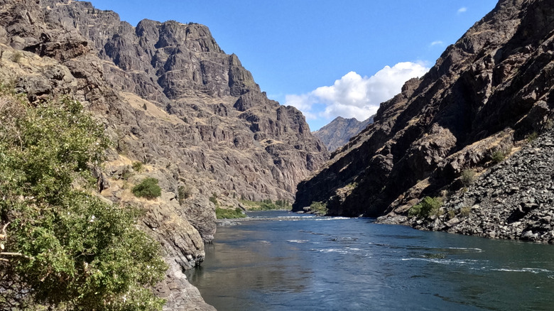
While many of Oregon's most popular attractions are located along the dramatic Pacific Ocean coastline and around the Cascade Mountains, don't forget about Eastern Oregon. Do yourself a favor and head to the southeastern part of the Beaver State, where you'll find America's deepest river gorge, known as Hells Canyon. Off the beaten path for most first-time visitors, this natural wonder is not to be missed. Enjoy scenic drives along the 208-mile Hells Canyon Scenic Byway, hiking and horseback riding in the Eagle Cap Wilderness of the Wallowa Mountains, and a nip into La Grande, a historic city along the famed Oregon Trail.
Hells Canyon was carved over millions of years by the powerful Snake River and sits near the border of Idaho. You can view the deepest part of the gorge from the Hells Canyon Overlook, located along the byway, which also offers amazing views of the Seven Devils Mountains. In some areas, it's around 2,000 feet deeper than the Grand Canyon! Of course, some of the best views are from the water. Cruise down the Snake River on a jet boat or join a raft tour with Hells Canyon Adventures. See the sights on a daytime tour or select a multi-day package that includes guided rafting or sturgeon fishing, as well as round-trip travel, camping, and home-cooked meals.
Methodology
To narrow down 11 of Oregon's must-visit destinations and attractions, we relied on information from reputable travel publications and tourism boards, including Travel Oregon, Visit LC Valley, Visit Eastern Oregon, Travel Portland, and Visit Bend, as well as government agencies like Oregon State Parks. For location-specific details, we sourced the U.S. Forest Service, National Parks Service, and United States Geological Survey. Trusted local resources like Tillamook, Gorge Friends, and Oregon Coast Trail were also used to gather facts and data.
Along with the author's personal experience, we determined each attraction's popularity based on visitor reviews, ratings, and experiences. We relied on recognized platforms such as AllTrails, The Dyrt, Google Reviews, and Tripadvisor, choosing from the most widely-recommended and highly-rated attractions for our final selection.