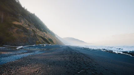
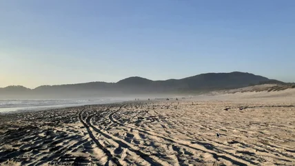
11 Top-Rated Hiking Trails in New Hampshire
New Hampshire's White Mountains offer more than magnificent scenery and popular tourist attractions. They are among the nation's most loved places to hike and climb. On its way from Maine to Georgia, the Appalachian Trail crosses the state along the ridgelines of the Presidential and Franconia ranges, over the summit of Mt. Washington (the highest peak in the Northeast), and through a vast wilderness area.

Spaced a day's hike apart along the trail are huts operated by the Appalachian Mountain Club (AMC), where hikers can sleep and eat with fellow mountain enthusiasts. Before starting any of these trails in the mountains, get a copy of the latest AMC White Mountains Guide, be sure you have plenty of water and warm clothing in your pack, and check a weather report. Abrupt and violent weather changes are common above the tree line, and snow has fallen here in all months of the year.
A good base for hikers in the White Mountains is the AMC's Highland Center, where you'll find a hostel, equipment, up-to-date trail information, and guided hikes for beginners and experts. A hiker shuttle makes it possible to take longer trails without returning to the same trailhead.
Not all New Hampshire's mountains are in this northern range, and you'll find hikes and climbs in the southern part of the state, too. Along with trails that require serious preparation, this list includes shorter hikes to waterfalls and even mountaintops suitable for families and those not interested in strenuous multi-day hikes.
Explore the state's dramatic scenery with our list of the top hiking trails in New Hampshire.
1. Mt. Monadnock

Reputed to be the most frequently climbed mountain in the world, Monadnock stands alone in southwestern New Hampshire, where its rocky summit offers 360-degree views that reach as far as Boston on a clear day.
You have several choices of hiking trails. The most popular is the White Cross Trail, a four-hour round-trip over moderate terrain. It begins at the entrance to Monadnock State Park off US 101 in Jaffrey. The longer Pumpelly Trail, more difficult but with more variety, climbs the opposite side of the mountain from the shores of Dublin Lake in Dublin, also off US 101. The Pumpelly Trail takes six or seven hours round-trip, beginning with a romp in the woods and ending in a scramble over rocks and boulders as the trail rises and drops along an uneven ridge above the tree line.
Because the mountain stands alone-it is 1,000 feet taller than any mountain within 30 or so miles-it can be windy, even on a hot day, and weather can change abruptly. No matter which trail you choose, the rocky top can be treacherous when wet, and fog can descend quickly to make finding the trail almost impossible. Remember that this is a very popular climb and easy to reach from Boston, so don't expect to be alone at the summit on a nice day.
A convenient place to stay near Mt. Monadnock is the Monadnock Inn, a large B&B-style inn with historic furnishings and updated amenities. For a more upscale lodging, try the Benjamin Prescott Inn, a classic New England inn.
Address: 116 Poole Road, Jaffrey, New Hampshire
2. Mt. Washington: Ammonoosuc Ravine Trail

One of the most rewarding trails in the Presidential Range, the ascent of the Northeast's highest peak alongside the Ammonoosuc River reveals a series of waterfalls, cascades, and views that rival any other route up the mountain.
It's about nine miles round-trip to the summit from the trailhead, which is just below the Base Station of the Mt. Washington Cog Railway, and a full day's hike. Below the summit, you'll pass Lakes of the Clouds and the AMC hut. You can return to the trailhead by the Jewell Trail, a much easier descent and with beautiful scenery of its own.
Whatever the weather at the base, remember that it is never warm at the summit; Mt. Washington's weather is so severe that Arctic equipment is tested here, and it's where the world's highest land wind velocity was recorded. Weather can change in an instant, and when clouds settle over the summit, visibility grinds to zero.
Address: Base Road, Bretton Woods, New Hampshire
3. Mt. Chocorua: Champney Falls Trail

New England's most photographed mountain is a familiar image, standing almost alone with its distinctive peak reflected in the mirror of Chocorua Lake. The most commonly climbed trail-Piper Trail-leads from Route 16, not far north of the lake and the famous view.
But from the Kancamagus Highway (Route 112), you can climb via the Champney Falls Trail, a longer route, but more varied and interesting. It also gives you the option of returning by another trail, making a loop that returns to within 100 yards of the original trailhead. A little more than a mile into the climb, you'll find a side trail to Champney Falls and neighboring Pitcher Falls. This makes a nice shorter hike if you're not up for the round-trip to the summit and back, but if the weather has been dry, the falls may be underwhelming.
The top of Mt. Chocorua is a rocky ledge, and this trail joins the Piper Trail to traverse to the peak. If you choose the longer route back, follow signs for the Bee Line and Bolles trails, but be aware that this makes a round-trip of nearly 10 miles and includes another climb through a pass that few people even know exists.
Be sure you have a trail map and the latest edition of the AMC White Mountains Guide before taking this route. Watch the weather closely, as Chocorua's rocky summit is treacherous when it's wet, icy, or wreathed in cloud.
Address: Route 112, Albany, New Hampshire
4. Appalachian Trail across the Presidential Range

One of the most beautiful sections of the entire Appalachian Trail is the crossing of the Presidential Range, over the summit of Mt. Washington, the tallest peak in the northeast. AMC huts dot the route providing bunks and meals, and a hiker shuttle makes it possible to hike hut-to-hut without backtracking.
A multi-day hike will take you from US 2 in Randolph to US 302 in Crawford Notch, and depending on how many side trails you choose to follow, covers between 13.5 miles and 18 miles and involves moderate to difficult hiking. It is largely above timberline, so weather is an important consideration. Don't even think about doing it unless you are fit, well equipped, and carrying the latest AMC White Mountains Guide.
Taken north to south, the route involves the ascent from Randolph to Madison Springs Hut (the Valley Way Trail is the easiest and most sheltered approach), where you join the Appalachian Trail. The view from this point is considered one of the best in the White Mountains. The Appalachian Trail follows the ridgeline with side trails to the summits of Adams, Jefferson, Clay, and Mt. Washington itself. The highlights of this airline route are between Madison Springs and Lakes of the Clouds Hut.
Official site: www.appalachiantrail.org
5. Mt. Willard

This small mountain that blocks the gateway to Crawford Notch rewards climbers with one of the White Mountains' finest views below timberline. Just over three miles round-trip, the trail climbs through cool woods until it emerges onto the cliffs at the top.
Here, you'll be treated to a panorama of Crawford Notch spreading below you (and to wild blueberries in mid-summer). There's no better place to appreciate how the glaciers carved and scoured out New Hampshire's notches as they receded.
If you're hiking with children-and this is a good family climb-be aware that the cliffs are high and the drop sudden. From the parking area opposite little Saco Lake, there are two more shorter hikes, one around the lake and up to Elephant Head rock formation, and the other to Beecher Falls.
Close to Mount Willard at the base of Crawford Notch, The Notchland Inn has luxury rooms and cottages and an excellent dining room. The inn is pet-friendly and offers a game room, gift shop, and free breakfast; most guest rooms include a fireplace.
Address: US 302, Crawford Notch, Bretton Woods, New Hampshire
6. Franconia Notch Ridge Trail

Somewhat shorter than the hike atop the Presidential Range, the eight-mile hike along the crest of the Franconia Ridge offers a similar multi-peak experience, this time adding the thrill of a knife-edge trail with mountainsides dropping away sharply on each side.
You can hike this circle trail in one day-it's about eight hours of hiking, or you can break the trip with an overnight at the Greenleaf Hut. Extra bonuses, along with the beautiful views down into Franconia Notch, are three mountain peaks and a series of waterfalls on the descent along Falling Waters Trail.
This final part of the loop from Cloudland Falls to Lafayette Campground, where the entire loop begins and ends, makes a good shorter climb suitable for families. On a hot day, take bathing suits for a cool dip in one or more of the pools.
Address: Lafayette Campground, US I-93/3, Franconia Notch, New Hampshire
7. Basin-Cascades Trail

Rarely does a hiking trail begin with two great kid-friendly attractions before you've even begun to climb. The Basin is a giant pot-hole carved and scoured by a glacial waterfall. Signage beside the trail describes its formation, and it's worth a stop even if you don't hike the trail that begins here.
Just a few yards beyond is one of the most appealing and approachable waterfalls in the state, a long gentle cascade over a series of ledges that invite climbing or sitting to enjoy the view. Follow the trail beside the falls to find an entire series of falls and cascades over flat ledges that seem to be designed for picnicking.
About half a mile above the first cascades is Kinsman Falls, then the trail gets steeper to Rocky Glen Falls. You can continue above this, crossing a wooden bridge and climbing to Lonesome Lake, but the trail becomes a bit rough for little legs.
To get to the trailhead, park at the exit signposted for The Basin and walk through the tunnel under the highway. Only a few miles south of The Basin is the family-friendly Indian Head Resort, with a swimming pool that will be welcome after the hike.
Address: Franconia Notch Parkway (US I-93/3), Franconia Notch, New Hampshire
Official site: http://www.franconianotch.org
8. Thoreau Falls and Zealand Falls

One of New Hampshire's least-known waterfalls, Thoreau falls is a 4.8-mile hike, or there's a shorter option of stopping at the smaller Zealand Falls at 2.7 miles. Either way, stop at the AMC Zealand Falls Hut for a cool drink and the view of Zealand Notch from the porch. It's a view only hikers can see, as no roads lead to this little-known notch.
Begin the hike at the end of Zealand Road, which leaves Route 302 at the Zealand campground, between Twin Mountain and Bretton Woods. The first two miles of the trail are through coniferous woodlands and along the bed of an old logging railroad before skirting a pond. The Zealand Trail ends at the junction of Ethan Pond and Twinway trails. Twinway, to the right, leads up alongside Zealand Falls to the AMC hut and views of the deep U-shaped Zealand Notch.
To continue to Thoreau Falls, take the left below Zealand Falls, onto the wooded Ethan Pond Trail. A sign marks the Thoreau Falls Trail, and shortly you'll come out onto the ledges at the head of the falls. These are a series of cascades, pools, and channels that culminate in a 20-foot straight drop. A trail beside the falls leads to the base for a different set of views.
9. Pawtuckaway Boulder Trail

The glaciers were busy during the last Ice Age, and they left New Hampshire a plentiful supply of natural attractions. While most of these are in the northern part of the state, giant boulders called "glacial erratics" can be found throughout New Hampshire.
But few places have such a fine collection of these as Pawtuckaway State Park, not far from the Massachusetts border between Concord and Portsmouth. Deep in the woods, granite boulders the size of small houses look as though they have been tossed here by a giant hand; in fact they were dropped here as the glaciers melted, having been scraped off mountaintops and cliffs exposed by the receding ice sheet.
Boulder Trail is about a two-mile loop if you follow the side trail to see the Devils Den, a pair of caves at the base of a high stone outcrop. Elsewhere in the park are two low mountains you can climb, along with a lake and campground. Park maps are available online or at the park.
Address: Pawtuckaway State Park, Nottingham, New Hampshire
10. Welch-Dickey Trail, Waterville Valley

At the southern edge of the White Mountains, Waterville Valley is best known for the ski and summer resort of the same name. But there's more to this valley cut by the Mad River, which reaches far back into a vast wilderness area that forms the southern part of the White Mountain National Forest.
A trail about 4.5 miles long climbs to a series of flat and gently sloping ledges that connect Welch and Dickey mountains. The trail forms a loop, so you don't have to double back. Although the mountains are not very high compared to the mountains farther north, they stand apart, so their summits reveal views that reach surprisingly far.
This is a good trail for children, but it is not a good trail to hike right after rain, as the smooth granite ledges can be very slippery when wet. Pick up a copy of Walking Trails of Waterville Valley at the Jugtown Store on the main plaza of the resort for this and several other good short hikes in the valley. To reach the trailhead from Route 49, follow Upper Mad River Road to Orris Road.
Waterville Valley has several choices of lodging in the self-contained resort village, including Snowy Owl Inn, a particular favorite for families with its large indoor pool.
Address: Orris Road, Waterville Valley, New Hampshire
11. Mt. Kearsarge Rollins Trail

You can climb 2,937-foot Mt. Kearsarge from either of two state parks. On the Winslow State Park side, it's a moderate hike of a little over a mile. You can vary the return trip by following the Barlow Trail from just below the summit, making a loop back down to the parking area. The Barlow Trail is about 1.7 miles, with ledges and more views on the way.
From the end of the road in Rollins State Park, on the side of the mountain, it's about a mile to the fire tower at the summit. If you prefer a more challenging but still short climb to the top, you can take the Lincoln Trail from the same parking area.
In the summer and fall, when the tower is staffed, the rangers usually welcome visitors. Although Mt. Kearsarge is only about 3,000 feet high, it stands alone, so the 360-degree views reach to the White Mountains and into Vermont, as well as encompassing several lakes. If you prefer a more challenging but still short climb to the top, you can take the Lincoln Trail from the same parking area. Note: don't confuse this mountain with the other Mt. Kearsarge near North Conway.
Address: Rollins State Park, Warner, New Hampshire
Best Time for Hiking in New Hampshire
The most popular time for hiking in New Hampshire is during the summer, when the shade of the forest trees is cool and the breezes above the tree line are refreshing. Spring hiking can be tricky in areas where the snow-melt renders trails muddy (and slippery), but it is rewarding to see nature emerge from its winter slumber. Autumn is a fine time to hike if you don't mind packing an extra layer, especially if you enjoy the bright foliage of the New Hampshire landscape.
More Related Articles on PlanetWare.com

Hiking Trails in New England: New England offers almost endless opportunities for outdoor activities. The neighboring Green Mountains offer a good variety of hiking trails in Vermont, and hiking is among the many outdoor activities in Acadia National Park in Maine. If you're interested in a more urban outing, you'll also find a surprising number of hiking and walking trails near Boston.

Where to Hike in the West: The desert and mountain landscapes of the West offer enticing areas for hiking. For ideas to get you started, have a look through our lists of top hikes in Utah and Arizona. Closer to the coast you'll find wonderful hiking trails in California, particularly in Yosemite National Park. Farther north, consider hitting the trails Washington or Oregon.