The 11 Best North Carolina Attractions To Check Out On Your First Trip
North Carolina might not be on everyone's bucket list, but it should be. This underrated U.S. state is jam-packed with natural beauty, including four national forests, nearly 300 miles of beaches, state parks with endless hiking trails, and the jaw-dropping peaks of the Great Smoky Mountains. Even if you're not a fan of outdoor activities, you'll find plenty to do in North Carolina that involves history and entertainment, like the largest natural science museum in the Southeast and the biggest privately-owned home in America.
To help make your first itinerary to North Carolina a little more manageable, we plotted out the 11 best attractions to check out on your trip, including all of the above and more. To do so, we evaluated the destinations with the greatest number of positive visitor reviews, as well as the attractions that the state is most famous for, and which sites are most likely to satisfy people of all ages and interests. Without further delay, here are the essential bucket-list destinations for first-timers to North Carolina.
Battleship North Carolina, Wilmington

Battleship North Carolina is no ordinary World War II museum — it is a piece of living history that also happens to have 15 battle stars earned during the war. Now anchored in the Cape Fear River off Eagle Island in Wilmington, visitors can explore the ship on a guided or self-guided tour. In doing so, you'll see what was once called "the world's greatest sea weapon," now a designated National Historic Landmark.
The ship was commissioned in 1941 and built in the New York Navy Yard before hitting the seas in 1942, and was retired four years later. During those years, the 35,000-long ton battleship was used in every major naval offensive mission in the Pacific Ocean during World War II. It took part in the Marshall Islands operation, the Central Pacific campaigns, the Battle of Philippine Sea, the invasions of Iwo Jima and Okinawa, and more, all the while being home to 2,000 troops.
Despite the ship's prowess, it nearly became scrap metal after it was decommissioned. However, great measures were taken to preserve the ship as a memorial and museum, and it has been open to the public since 1962. Visitors are invited to explore its nine sprawling levels, which include gun turrets and troops' quarters. The experience typically lasts around two hours and costs $14 per person ages 12 and over, as of this writing. For senior citizens, the price is $10 per person, and $6 per child ages 6 to 11.
Biltmore Estate, Asheville

The United States may not have an official royal family, but if it did, the Vanderbilts would certainly qualify. The family, famous for building an empire in the shipping and railroad industries, owns the Biltmore Estate, a French Renaissance-style mansion in Asheville, North Carolina. The property spans 8,000 acres, making it the largest privately owned home in the country. The palatial residence has 250 rooms packed with art, original furnishings, antiques, and amenities fit for royalty, including a bowling alley, which visitors can see on a self-guided or guided tour.
Set against the backdrop of the Blue Ridge Mountains, the grounds are incredibly scenic. It boasts 75 acres of colorful gardens crafted by Frederick Law Olmsted, the acclaimed architect who also designed Central Park, including an Italian garden, a rose garden, an azalea garden, and even a lush conservatory with orchids. Another must-see is the on-site Biltmore Winery, which offers tastings of its award-winning wines. The winery, which makes over 20 premium wine varieties, is said to be the most-visited winery in the country.
The Biltmore Estate was built by George Vanderbilt over the span of six years, culminating in 1895 when the lavish country home opened to friends and family. He later lived there with his wife, Edith Stuyvesant Dresser, a descendent of the last Dutch governor of New York, and their daughter. Today, visitors can explore the estate all year round, and ticket prices range from $70 to $130 per adult, depending on the season.
Blue Ridge Parkway
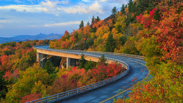
If you're all about the journey rather than the destination, there's no place better to visit in North Carolina than the Blue Ridge Parkway. Stretching 469 miles, it's considered the longest linear park in the country. This winding scenic road travels from Shenandoah National Park in Virginia to Cherokee in North Carolina. Along the way, you'll encounter everything from hiking trails, to waterfalls, to over 270 scenic overlooks, to mountain towns. The Parkway — now a National Scenic Byway — dates back to 1935, when it was commissioned as part of the New Deal by President Franklin D. Roosevelt to help mitigate effects of the Great Depression. It was finally completed more than a half-century later and has been open to the public ever since. With no entry tolls or fees, this attraction is accessible for everyone — all you need is a set of wheels and a full tank of gas.
If you're exploring the North Carolina side of the Parkway, one of the spots to look out for is the Thunderstruck Ridge Overlook, which offers breathtaking panoramic vistas of the Great Smoky Mountains. Then, stop in Waynesville, a small North Carolina town that feels like a trip back in time with its quaint shops and general store. Next, head to Looking Glass Rock Overlook, which presents front-row views of the extraordinary Looking Glass Rock and the Dragon Tree, an otherworldly tree that looks more like a mystical animal than mere foliage.
Chimney Rock State Park, Chimney Rock
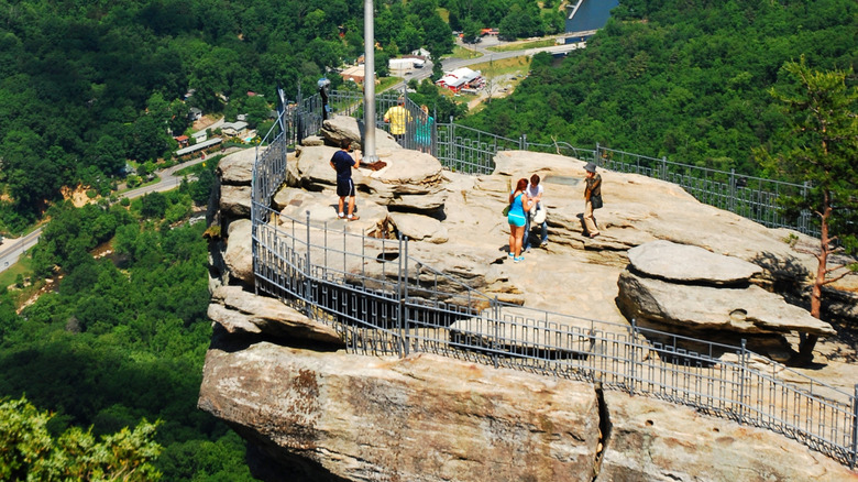
If Chimney Rock State Park's 400-foot waterfall looks familiar to you, you're not imagining things — the landmark was featured in the movie "The Last of the Mohicans," starring Daniel Day-Lewis. The waterfall, called Hickory Nut Falls, is one of the tallest in the eastern United States, and is reachable by a short hike. However, the scenic falls aren't even the most popular attraction at the park. That title belongs to Chimney Rock, which presents stunning views of Hickory Nut Gorge, the Rocky Broad River, Lake Lure, and surrounding mountains. The 315-foot rock dates back roughly 535 million years and is considered one of North Carolina's most iconic attractions. To get to the top, visitors can either climb 500 steps along the Outcroppings Trail, or take the convenient elevator. Though challenging, the staircase to the top has been one of the most popular activities in the state since it was built in 1885.
To gaze from the top of Chimney Rock, you'll have to do some planning beforehand. Visitors who wish to climb to the top of the rock must book reservations online in advance, unless you are an annual passholder. Tickets for kids ages 5 to 15 are $8, and $17 for visitors over the age of 15. Expect to spend about one to two hours here, at the very least. The park boasts all kinds of attractions for visitors of all ages, including an Animal Discovery Den, a butterfly garden, and a picnic area.
Grandfather Mountain, Boone
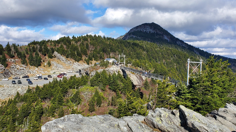
Grandfather Mountain in Boone, which is one of the state's most popular attractions, is said to have received its name because early pioneers believed it resembled an elderly man's face. However, there's a lot more to do at this mountain — one of the tallest in the Blue Ridge Mountain Range — than simply admire the rocks. It's home to the Mile High Swinging Bridge, a bridge suspended roughly 5,280 feet above sea level that leads to the stunning Linville Peak. The bridge was first built in 1952 by the original owner of the mountain, and has since been reinforced with galvanized steel rails and sturdy cables. The views span all the way to Mount Mitchell, the highest mountain east of the Rocky Mountains.
A designated UNESCO International Biosphere Reserve, the park is also home to the Mildred the Bear Environmental Wildlife Habitats. Named after a bear named Mildred who chose to make the park her home, the habitats house elk, black bears, cougars, bald eagles, and river otters. Visitors can also check out the park's Wilson Center for Nature Discovery to learn more about the plants and geology of the mountain. To immerse yourself in the pristine surroundings, embark on one of the hiking trails at the park, including the steep trek to Calloway Peak. Ticket prices are $28 per person ages 13 to 59, $12 for kids ages 4 to 12, and $26 for visitors ages 60 and older.
Jockey's Ridge State Park, Nags Head
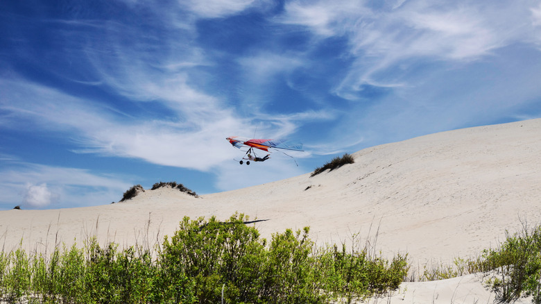
Take one look at the sand dunes in Jockey's Ridge State Park and you'll think you're in the Sahara Desert rather than Nags Head in the Outer Banks of North Carolina. The park is known for its towering sand dunes, the tallest on the East Coast at 80 to 100 feet tall. The dunes have been a popular attraction for well over a century, but the dunes themselves date back much longer than that. It's believed that they formed when ancient storm surges, followed by strong winds, forced ocean shoal onto the land.
The dunes were almost claimed by developers who planned to build homes on the land, but locals intervened, and in 1975, Jockey's Ridge State Park was formed, which now spans 420 acres. The name of the park is thought to be inspired by settlers, who supposedly acted as "jockeys" and raced wild ponies around the dunes.
Although you can't hop aboard a wild pony at the park today, you can experience the wonder of the dunes by sand boarding, kiteboarding, hiking, and hang gliding — in fact, it's considered one of the premier destinations for hang gliding on the East Coast. No matter how you enjoy the dunes, you will be able to see all the way to the Roanoke Sound from the top.
NASCAR Hall of Fame, Charlotte

Home to the Charlotte Motor Speedway and the nearby North Carolina Auto Racing Hall of Fame, it's only fitting that Charlotte, dubbed the "stock car racing capital of the world," is also where the NASCAR Hall of Fame was established in 2010. This site is so popular that around 40% of visitors trek more than 500 miles to visit. Visitors from every U.S. state and six continents have descended on the 5-acre complex to see the world of NASCAR come to life. Showcased within the massive venue are countless NASCAR artifacts, a 5,800-square-foot gift shop, and interactive exhibits, including an iRacing simulator and a Pit Crew Challenge.
In the Hall of Honor, visitors can learn about iconic NASCAR drivers like Donnie Allison, Chad Knaus, and Jimmie Johnson. The NASCAR Hall of Fame is also home to seven event venues. These venues host a combined total of 300 events every year, ranging from corporate meetings to weddings. Individual tickets to the NASCAR Hall of Fame cost $22 per child ages 4 to 12, $29 for visitors ages 12 and older, and $26 for adults ages 65 and older, at the time of writing. Though admission is relatively cheap, keep in mind that Charlotte it considered one of the most expensive travel destinations in America.
North Carolina Arboretum, Asheville

As a mountainous city, Asheville is in touch with its outdoorsy side. For this reason, it's no surprise that it is also home to the North Carolina Arboretum, a 1,200-acre site in the Pisgah National Forest that's free to visit for all. It was founded by a University of North Carolina at Chapel Hill botany professor named William Chambers Coker, who planted a garden for his students that was expanded through the decades by university and horticulturist donations. Visitors can tour the original site of this majestic property, aptly named the Coker Arboretum.
In 1966, nature trails were added to the area, allowing visitors to enjoy the sprawling grounds of what would eventually become the North Carolina Arboretum. There are 3 miles of trails snaking through the 88-acre forest, including Oak Hickory Trail, Steamside Trail, Elephant Rock Trail, and the shared cyclist-pedestrian path between Old Mason Farm Road and Laurel Hill Road.
Another highlight of the arboretum, especially for animal lovers, is the Mason Farm Biological Reserve. Throughout its 367 acres, you can spot 29 types of mammals, 28 species of reptiles, and 216 kinds of birds, along with rare plants. Another favorite is the 127-acre Parker Preserve, which includes upland oak hickory forests, mesic mixed hardwood forests, and old field pine forests blanketed across the ever-changing terrain. Keep an eye out for the remains of a cabin built in the 1830s that was reportedly used as a refuge on the Underground Railroad, as well as historic homes dating back to the 1800s.
North Carolina Museum of Natural Sciences, Raleigh

From little ones to lifelong learners, there's no better — or bigger — museum in the Southeast to discover Earth's many wonders than the North Carolina Museum of Natural Sciences in Raleigh. Throughout the museum's four floors, visitors can check out a 70-foot-diameter globe with a three-level theater, complete skeletons of a tyrannosaur and triceratops, the remains of a giant sloth dating back 1.5 million years, and so much more. This Smithsonian Institution-affiliated museum is the most-visited museum in North Carolina, and first-time visitors of all ages can't afford to miss out.
In addition to fossils and skeletons, you can also see live animals at the North Carolina Museum of Natural Sciences. Animals including snakes, turtles, frogs, freshwater and saltwater fish, and butterflies all call the museum home. Best of all, admission to the museum is free. The museum always has new exhibits on display that cover fascinating topics like outer space, pollinators, spiders, and deep-sea creatures, so there's always something new to see. Special events are also frequently held at the museum, like 3D movie screenings, hands-on workshops, and Bugfest, one of the most unique food festivals in the world.
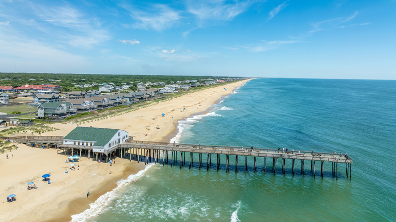
Outer Banks

Beach destinations in other parts of the country are often crowded, but the Outer Banks — barrier islands off the coast of North Carolina — have remained relatively calm despite their extraordinary beauty. That's partly due to the fact that these islands span 200 miles, so there's room for everyone here — as long as you have a car, or at least a bike, to get around. Besides the region's natural beauty, the small towns nestled on these islands are packed full of history. It's where the Wright brothers took flight on their first aircraft, and where the Lost Colony of Roanoke once lived.
Whether you're a history buff, an outdoor explorer, or a family seeking entertainment for the kids, you'll find plenty to do in the Outer Banks. Visitors can fish, kayak, jet-ski, and surf, or take advantage of the area's many unique attractions. Discover over 3,000 shipwrecks that give the Outer Banks its sinister reputation of "the graveyard of the Atlantic," or see wild Spanish mustangs grazing and frolicking around the shores of Carova Beach in Corolla. Be sure to visit the beaches of Manteo, a captivating North Carolina town with storybook charm, and the striped Bodie Island Lighthouse that dates back to 1871. But, the history of the Outer Banks dates back much longer than the 19th century. The islands were originally used in the 1700s as the site of a European colony. Even the infamous Blackbeard the pirate loved the Outer Banks, as it was where his preferred hideaway was located.
Wright Brothers National Memorial, Kill Devil Hills
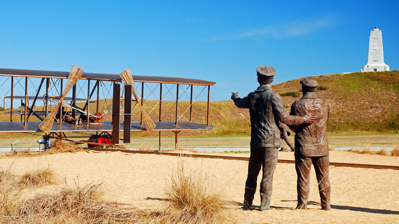
The famous site where brothers Orville and Wilbur Wright successfully launched their first-ever powered aircraft, called the Wright Flyer, is now the Wright Brothers National Memorial. Plans for the monument began in 1928 on the 25th anniversary of the brothers' legendary flight. The 60-foot Art Deco-style monument is in one of the Outer Banks' three national parks. It commemorates the day in 1903 when the brothers' airplane successfully took flight, which would change the world forever. The memorial is located in Kill Devils Hills, an underrated North Carolina beach town with sand dunes and shops, aptly nicknamed the "birthplace of aviation."
Before visiting the monument, head to the on-site museum and visitor's center, a National Historic Landmark that features interactive exhibits that showcase the Wright brothers' accomplishments. See the commemorative bronze and steel sculpture that depicts the brothers and onlookers watching the plane as it prepares to soar. Admission to the memorial is $10 per person ages 16 and older, and free for visitors ages 15 and younger.
Methodology

With a storied past dating back to 1789 and a diverse landscape spanning over 53,000 square miles, you can bet that there's plenty to see and do in North Carolina. The options vary widely from natural attractions to world-class institutions and historic landmarks of all kinds. With so much to choose from, we narrowed down North Carolina's top destinations for first-time visitors, so you won't head home wondering, "How did we miss that?"
We first evaluated which sites have the greatest number of positive ratings and reviews on the platform Tripadvisor, so you can rest easy knowing that the vast majority of previous visitors have found the admission fees worth it. Then, we used a variety of resources such as local tourism boards and renowned travel publications to determine the most well-known and famous sites in North Carolina. One example is the NASCAR Hall of Fame, an attraction that draws people from all over the world.
The final element of our selection process came down to the versatility of each destination and its ability to appeal to visitors of all ages. Our guide includes a diverse range of activities to suit a wide variety of interests. Avid hikers will savor the climb to the top of Chimney Rock, while history buffs — especially those fascinated by legendary American vessels — will appreciate Wright Brothers National Monument and the World War II Battleship. It's safe to say that, in North Carolina, every type of traveler will find their perfect fit.