California's Top 10 Tourist Hot Spots Worth Visiting On Your Next Trip

Few places have captured the world's imagination quite like California. From the glitz of Hollywood's movie studios to the rugged cliffs of the Pacific Coast Highway, California has always been a destination for people who want their lives to be an adventure. Here, surfers chase the perfect wave, artists of all kinds find inspiration, and travelers leave pieces of themselves behind at every turn. Ever since becoming a state in 1850, California has beckoned those hoping to strike it rich during the gold rush, or simply live out their lives in the Golden State.
In this guide, we'll travel throughout the state to explore 10 must-see destinations that define California. Some of these tourist hot spots may be busy, but they all have a starring role in the local culture. With endless sunshine, major cities like Los Angeles and San Diego, and beautiful natural scenery, it's clear that the state has something for everyone — and that all 10 of these locations should be on your travel bucket list soon.
Hollywood Boulevard (Los Angeles)

No trip to California is complete without a stroll down Hollywood Boulevard, the heart of Los Angeles's century-long entertainment legacy. In the 1920s, LA became the seat of the movie-making world, and the first permanent star was laid for "High Noon" director Stanley Kramer in 1960. Today, this iconic stretch of sidewalk features inlaid stars that honor over 2,700 of Tinseltown's finest across film, music, and television.
Start your stroll at the historic TCL Chinese Theatre, where generations of movie stars have immortalized their handprints and footprints in the courtyard cement. Just down the street, you'll find the Dolby Theatre, home to the Academy Awards since 2001. Throughout the year, the Dolby also hosts numerous concerts, comedy shows, and other events that are open to the public. A third theatre just across the street, El Capitan, is a beautiful Golden Age movie house operated by The Walt Disney Company. There, guests can enjoy screenings of Disney, Marvel Cinematic Universe, and Star Wars films.
In addition to its legendary landmarks, the modern iteration of Hollywood Boulevard has plenty of gems for fans of various franchises. One standout is the Scum and Villainy Cantina — a self-proclaimed "geek bar" where fans can try galactic cocktails and hang out in a space that feels like it fell straight out of Mos Eisley. For those who tend toward Old Hollywood spots, the timeless Musso & Frank Grill has been serving celebrities and tourists alike since 1919. Between street performers, souvenir shops, and a hotel that might be haunted by Marilyn Monroe, Hollywood Boulevard is where the magic of Hollywood has been shining bright for over 100 years, making it a can't-miss stop.
Disneyland Resort (Anaheim)

While Walt Disney World Resort is my home park, there's something absolutely magical about walking into the only Disney theme park Walt Disney himself ever saw. Opened in 1955, Disneyland Resort in Anaheim is called the "Happiest Place on Earth" for a reason. From the moment you walk down Main Street, U.S.A. — with the unmistakable smell of popcorn in the air and Sleeping Beauty Castle in front of you — it's easy to see why this park holds such a special place in millions of hearts.
Classic rides like "it's a small world," Pirates of the Caribbean, and Jungle Cruise still deliver the timeless magic they have for generations of families, while newer favorites like Star Wars: Rise of the Resistance at Galaxy's Edge and Web Slingers: A Spider-Man Adventure at Avengers Campus have allowed 21st-century Imagineers to take Disney's signature immersive experiences to a whole new level.
For travelers and locals, Disneyland's seasonal celebrations are highlights every year. Celebrate the magic of spooky season during the Oogie Boogie Bash Halloween party at Disney California Adventure Park. Then, during the holidays, Disneyland Park's A Christmas Fantasy Parade transforms Main Street into a winter wonderland. As Walt himself said, though, "We keep moving forward," and the DisneylandForward initiative is poised to do just that. Among other announcements, it has already been confirmed that Avengers Campus will expand with two new attractions, Disney's first-ever "Coco" ride is in the works, and Disneyland Resort is getting its own "Avatar" area — akin to Pandora at Disney's Animal Kingdom Park in Florida. For lifelong fans and first-time visitors, Disneyland is more than a theme park — it's an ever-evolving piece of American history.
Golden Gate Bridge (San Francisco)
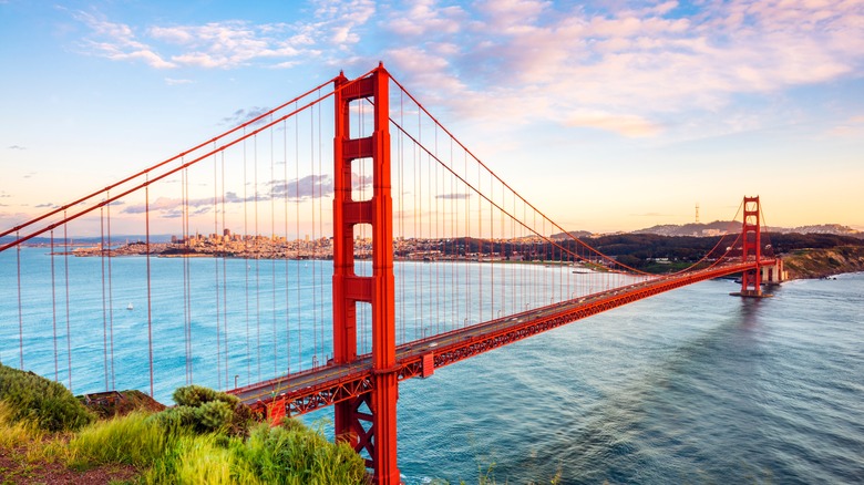
Arguably the most iconic landmark in the world, San Francisco's Golden Gate Bridge captures the spirit of California better than any other. Over the years, it has become an international symbol of innovation, architectural beauty, and the West Coast dream of prosperity. Stretching 1.7 miles across the Golden Gate Strait, this Art Deco masterpiece has connected San Francisco to Marin County since 1937. Completed after four years of construction and the tragic deaths of 10 workers, this bridge has always defied the odds — built in a place many believed it was too foggy and windy to successfully construct a roadway. In fact, it was even dubbed "the bridge that couldn't be built." Today, Golden Gate's signature International Orange paint color helps it stand out against San Francisco's often cloudy skies.
For the best views, there are a few key spots you should know. Battery Spencer, for example, offers beautiful views of the bridge, along with both the Pacific Ocean and the San Francisco skyline. Meanwhile, Crissy Field, boasts a dramatic view of the Golden Gate suspended above the San Francisco Bay. Both spots are ideal for photos, picnicking, or catching a stunning sunset or sunrise. Visitors should also take the time to check out the nearby Golden Gate National Parks. Comprised of 80,400 acres, there is no other area of the National Parks system that receives as many annual visitors. Whether you choose to explore Cliff House, hit the trails in Dias Ridge, or check out the 21st century's first new National Park lodge, Cavallo Point, you'll find something to love.
Big Sur (Central Coast)
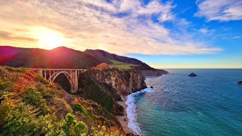
Few stretches of coastline in the world are as well-known as Big Sur. For about 90 miles, travelers can take in epic views that have drawn everyone from Henry Miller to Jack Kerouac over the decades. Running along the Pacific Coast Highway from Carmel-by-the-Sea to the famous Hearst Castle, this stunningly beautiful region has been voted one of the top 25 travel destinations in the United States.
If you want to take the ultimate Big Sur road trip, there are a few spots you can't miss. For starters, Bixby Creek Bridge is one of the area's most popular photo ops — especially after it was featured in the opening credits of HBO's "Big Little Lies." You'll also want to make a stop at Pfeiffer Beach, where you can see its unique purple sand. Finally, the Point Sur Lighthouse is another great landmark to check off your list. Opened in 1897, this historic structure is a Cold War-era relic.
For those who want to stretch their legs, there are numerous hiking trails in the Big Sur region. Among the most recommended are Partington Cove, which offers gorgeous cliffside views of the Pacific Ocean, and the Salmon Creek Falls Trail, where you can climb on boulders in a creek to reach the waterfall. For dining, Nepenthe has been serving travelers since 1949, when the earliest Beat Generation artists frequented Big Sur. Situated over 800 feet above the water, this cliffside restaurant has hosted everyone from the aforementioned Miller to Rita Hayworth and Orson Welles. Meanwhile, Big Sur Bakery is a rustic, artsy spot open from 8 a.m. every day but Tuesday. For lodging during your trek, there are dozens of options along the way. For those who want to splurge, though, Post Ranch Inn is a luxurious choice.
Yosemite National Park (Tuolumne, Mariposa, Mono, and Madera Counties)
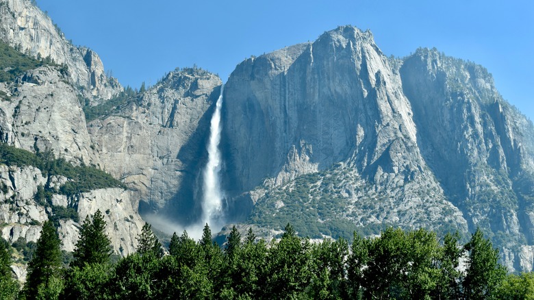
One of the jewels of the American wilderness, Yosemite National Park is among California's most impressive natural landscapes. The area was initially protected by President Abraham Lincoln in 1864. However, it officially became part of the National Park system under President Teddy Roosevelt, himself a famous outdoorsman, in 1906. Today, visitors can still enjoy the same waterfalls, meadows, and centuries-old sequoia groves that people fell in love with at the turn of the century.
The park's major icons, like El Capitan, are legendary. Made even more famous by the film "Free Solo," this granite wall stands over 3,000 feet tall — more than three times the height of the Eiffel Tower! Then, there's Half Dome, Yosemite's 5,000-foot-tall mountain, which was once thought to be unscalable. Today, it presents a rewarding challenge for hikers who are in shape for its 14- to 16-mile round-trip trek. For stunning views of Half Dome without climbing it, hit up Yosemite's easy Mirror Lake hiking trail.
Yosemite Falls, though, is the real showstopper at this National Park. Made up of three different waterfalls that measure upwards of 2,200 feet tall in total, it's among the tallest in the world. The easiest way to see the falls is to walk along a one-mile loop hike from a shuttle stop. However, adventurous travelers can spend a full day hiking to the summit. Since it's impossible to see and do everything at Yosemite National Park in a day, it's advisable to spend at least one night at a hotel. Among the best options are The Ahwahnee, a luxury hotel operating since the 1920s, the Yosemite Valley Lodge close to Yosemite Falls, and the rustic Curry Village, where travelers have been staying in canvas tents since 1899.
Lake Tahoe (California–Nevada Border)
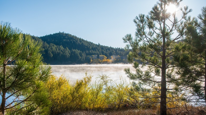
Located on the border between California and Nevada, Lake Tahoe is counted among the best ski destinations in the United States. However, it also offers year-round vacation excitement for families, solo travelers, and adventurous souls looking to find thrills in California. During the winter months, Tahoe is a skier's paradise. Resorts like Heavenly, Northstar, and Palisades Tahoe (formerly Squaw Valley, host of the 1960 Winter Olympics) offer world-class slopes, après-ski chalets, and beautiful lodging options. The Village at Palisades, for example, features balconies, complete kitchens, and fireplaces in nearly all of its suites. Meanwhile, Northstar has multiple types of accommodations — including private homes with three to four bedrooms, mountainside or ski trail condos, and the Timber Creek Lodge hotel.
When the snow melts, summer in Lake Tahoe is equally as enjoyable, and the lake becomes a popular destination for all sorts of activities. Boating along Lake Tahoe's 72 miles of coastline is a highlight for many, as is exploring Cove East Lighthouse, the highest-elevation lighthouse in the nation. There are also hiking trails for all fitness levels — from the dog-friendly Eagle Falls Trail to three different hikes that lead to the summit of 9,739-foot Mount Tallac. The truly adventurous can even spend a week living off the land in the Desolation Wilderness, or cliff jumping into the water. Year-round, Tahoe's surrounding towns, like South Lake Tahoe and Tahoe City, offer excellent dining, nightlife, and shopping options.
Napa Valley (Napa County)

Synonymous with living the good life, Napa Valley is California's world-famous wine country. There are dozens of different ways to experience Napa — from going all out and staying in an indulgent five-star resort like Auberge du Soleil to checking out wine tastings under $50 and sticking to a budget. Many travelers who come to this part of California start their journey along the Silverado Trail, which is lined with a who's who of Napa's most prestigious wineries, including Stag's Leap Wine Cellars, Baldacci Family Vineyards, and Fisher Winery. Nearby, visitors can visit Castello di Amorosa, a Tuscan-style castle that feels like it was plucked from an Italian storybook. Modeled in 14th-century style, the Castello offers daily wine tastings and food offerings.
For a one-of-a-kind experience, book the Napa Valley Wine Train, which traces its story to 1864 when rail travel first came to Napa. Thanks to an idea conceived in the 1980s, today's wine train takes travelers on a historic route from Downtown Napa to St. Helena and back. There are multiple Wine Train experiences available, including luxury seven-course tasting journeys, daytime trips that stop at several celebrated wineries, and nighttime experiences where you'll dine in the train's glass-ceilinged Vista Dome. No matter which package you choose, it will be a throwback to the golden age of travel. Adventurers who come to Napa should also consider booking a hot air balloon ride, while food lovers will enjoy gourmet restaurants like The French Laundry and Brix.
Santa Monica Pier (Santa Monica)
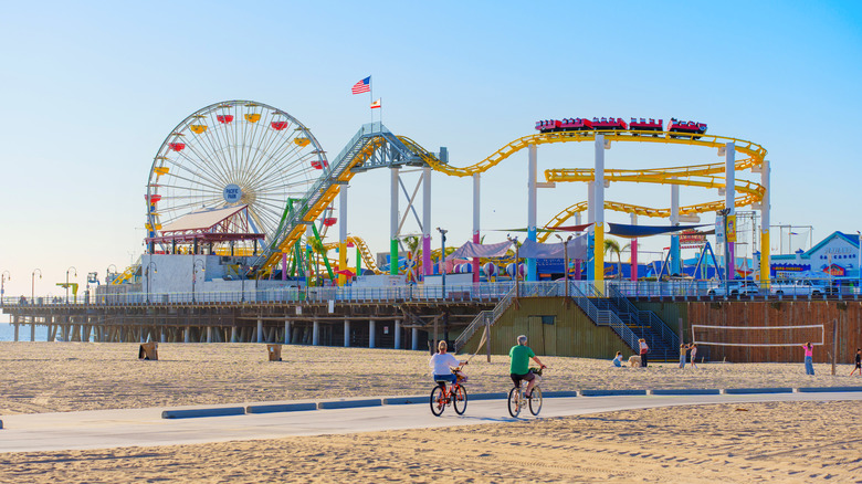
Santa Monica is the epitome of Southern California cool, with a mashup of art galleries, Route 66 nostalgia, great beaches, and Broad Stage, which hosts local and international musicians. It was also the birthplace of Hollywood royalty like Shirley Temple, Charlie Chaplin, and Robert Redford. Its iconic Santa Monica Pier, however, is the main attraction for many tourists. Featured in countless films and TV shows — including "Iron Man," "Three's Company," and "Forrest Gump" — it's arguably one of California's most recognizable landmarks. Over 100 years old, the Pier features street performers, restaurants, and retro-inspired carnival rides.
During the mid-century, Santa Monica was home to Pacific Ocean Park, one of America's most nostalgic now-closed amusement parks. Today's visitors can enjoy the Pier's Pacific Park instead. Home to the Pacific Wheel — the only solar-powered Ferris wheel in existence — the park also features a roller coaster with a 55-foot drop, and the Santa Monica Pier Carousel, one of the only remaining attractions from the original 1909 Pier. Just a few blocks away, visitors can check out the Third Street Promenade, a pedestrian-only area filled with local boutiques, public art, and restaurants.
San Diego Zoo (San Diego)

Set amid the urban cultural oasis that is Balboa Park, the San Diego Zoo is the eighth largest zoo in the world, and one of the most respected. This is a place where visitors and local families can journey from the jungles of Asia to the savannas of Africa without ever leaving Southern California. Since it was founded in 1916, it has become a global leader in animal care, conservation, and education thanks in large part to the efforts of the San Diego Zoo Wildlife Alliance. Whether you are an active amateur conservationist yourself or you simply want to see this iconic destination, the San Diego Zoo is a SoCal must-do.
Home to more than 12,000 animals from over 680 unique species, the zoo is designed as an immersive experience where each new area transports guests to a different region of the globe. Among the San Diego Zoo's most famous exhibits is the Panda Ridge, where giant pandas roam. For an extra fee, you can even take a guided 60-minute morning walk for special views of the panda bears! Other popular areas include the Elephant Odyssey, the endangered African Penguin exhibit, and the polar bears in the Northern Frontier section. Finally, don't miss a ride on the Skyfari Aerial Tram, which offers a bird's eye view of the zoo and the San Diego skyline.
Alcatraz Island (San Francisco Bay)
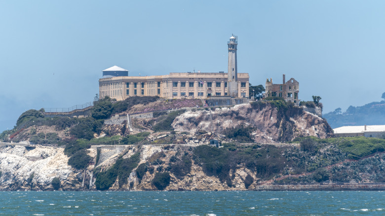
Sitting in the middle of San Francisco Bay, Alcatraz Island is one of America's most notorious landmarks. This former maximum security prison is a place where historical facts and legends meet to make for an unforgettable visit. Once home to the nation's most notorious criminals — ranging from Al Capone to Robert Stroud (the "Birdman of Alcatraz"), and Ellsworth "Bumpy" Johnson — the island penitentiary was designed to be inescapable; although that never stopped daring inmates from trying during its 29 years in service. While most would-be escapees were apprehended promptly, the fates of three men who attempted to escape in 1962 remain a mystery. And although the FBI concluded that the men likely drowned in the Bay, amateur sleuths sometimes still speculate that the trio survived.
Today, Alcatraz is overseen by the National Park Service, and visitors can tour the former prison to see its stark cells, mess hall, and hauntingly atmospheric isolation block. Various tour options are available. While your ferry ticket to "The Rock" includes a self-guided cellhouse audio tour, guests can also learn more about Alcatraz's history via guided tours. For an eerie experience, consider booking a night tour, which focuses on purported hauntings and supernatural occurrences on the prison island. Cell 14D, for example, is said by many paranormal enthusiasts to remain significantly colder than any other cell, signifying the presence of a ghost.
Methodology

For this guide, I relied heavily on official sources to ensure accuracy in terms of historical context, key details, and visitor information for the final selection of California's top 10 tourist destinations, including Yosemite National Park, Disneyland, Golden Gate National Parks, the San Diego Zoo, Alcatraz Island, Napa Valley, and the Santa Monica Pier. Additionally, I also consulted official websites for various attractions, restaurants, and lodging options — such as Tahoe-area ski resorts, Brix and French Laundry in Napa Valley, and Nepenthe in Big Sur — in order to provide up-to-date and trustworthy information.
Finally, I also used my own knowledge of certain spots — like Disneyland, Hollywood Boulevard, and the Golden Gate Bridge — to include personal insights and lesser-known details. Where I needed to supplement my research and knowledge, I turned to high-authority travel blogs and local photographers who regularly shoot at these locations.