10 Awesome Michigan Hot Spots That Belong On Your Bucket List

The Mitten State may be most famous for its Great Lakes, but Michigan is home to a number of hidden gems. From the turquoise waters of its glacial lakes to the rolling sand dunes along its shores, Michigan offers some of the most spectacular and diverse scenery in the Midwest. The state is also home to picture-perfect small towns, thick forests, and lush wine country. Not to mention Michigan's largest city of Detroit, which houses one of the most impressive art collections in the country.
But, don't just take our word for it — book your Michigan adventure and discover it for yourself. I have spent over two decades traveling extensively from Michigan's southernmost point to the stunning Upper Peninsula, discovering countless hot spots along the way. This article is just the beginning of the historic, natural, and cultural wonders of this unique state, including some of the most highly-rated destinations by tourists and the must-visit attractions recommended by Michigan locals.
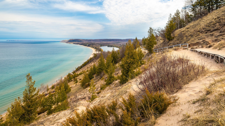
Sleeping Bear Dunes National Lakeshore, Empire
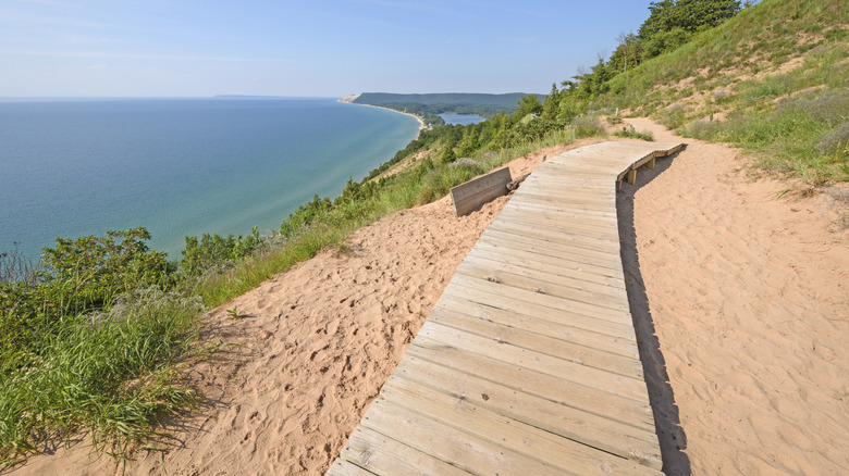
Sleeping Bear Dunes National Lakeshore in Empire, Michigan is home to dramatic peaks of golden sand. The tallest dune stretches a whopping 460 feet above Lake Michigan, offering sweeping views of its vibrant turquoise waters. Hikers aiming to feel the burn will love the Dunes Trail, a challenging 3.5 mile route over various sandy peaks. Because this path requires hiking directly in the sand, it takes about two to four hours to complete, depending on your speed.
Folks who aren't so keen on hiking may prefer the Pierce Stocking Scenic Drive, a 7.4-mile loop to 12 different viewpoints. Visitors can peer out at a thick pine plantation, gaze at Lake Michigan from the gorgeous Dune Overlook, and view the peak of Empire Bluff from the North Bar Lake Overlook. Just be aware that this route is available to cars and bikes, but trailers are not permitted.
To arrive at the Sleeping Bear Dunes National Lakeshore, drive 45 minutes from the Cherry Capital Airport in Traverse City, Michigan. A standard entrance pass to explore the dunes costs $25 per private vehicle. This is the best deal for day visitors traveling in groups, as all visitors over the age of 16 arriving on foot or bicycle must purchase a standard pass to enter.
Windmill Island Gardens, Holland
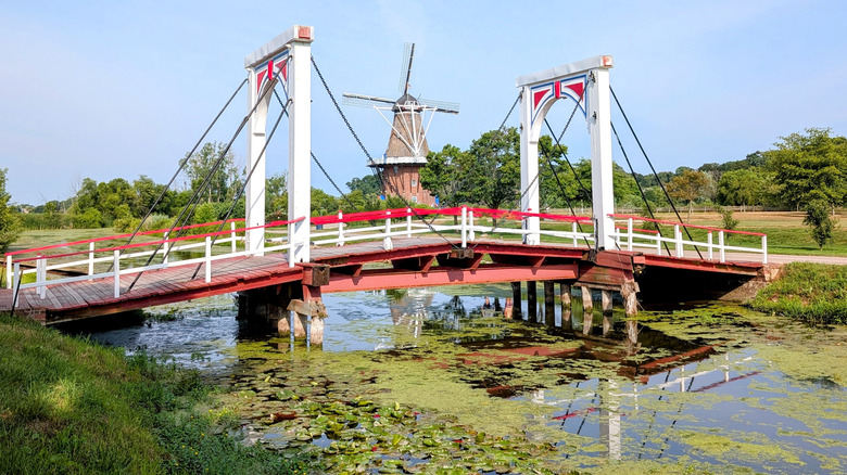
Jetting off to Europe for a quick getaway may sound alluring to many travelers based in North America, but the cost is not always feasible. Enter Holland, Michigan. Situated less than three hours from both Chicago and Detroit by car, this adorable town is brimming with all the charm of a real Dutch city. With cute historic buildings, a clog-making workshop, and an authentic Dutch bakery, Holland is one of the few American cities that feel like popular destinations in Europe. The crown jewel, though, is the Windmill Island Gardens.
Open every year from April to October, the Windmill Island Gardens are home to real fields of seasonal tulips in addition to giant wooden tulip carvings. The gardens also feature fields of bright yellow sunflowers and an actual Dutch-style windmill. It's an ideal family-friendly attraction, with plenty of space for little ones to run around, as well as an antique hand-painted merry-go-round. The Dutch-themed gift shop offers cheese samples and all kinds of delicious treats.
At the time of writing, tickets to the Windmill Island Gardens cost $13 for adults and $6 for children between the ages of 3 and 15, but prices vary by season. During the Tulip Time festival in May, adults pay $15 and children $7. Extended season tickets in late October cost just $5 for per adult, while children under 15 can visit for free.
Shipwreck tours of Lake Superior, Munising
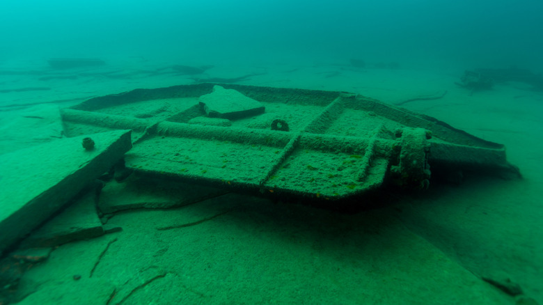
Lake Superior is the cleanest lake in the U.S., but it is also known for its ice-cold temperatures and treacherous waves. The northernmost of all the Great Lakes, it boasts choppy waters, brutal winds, and sailor's lore. Approximately 550 sunken ships sit at the bottom of Lake Superior. These days, visitors can learn about these ill-fated voyages by heading to the town of Munising in Michigan's Upper Peninsula, or U.P., and embarking on a glass-bottom boat tour of the lake's most famous shipwrecks.
Two of the most fascinating wrecks to view in the region are the Bermuda and Herman H. Hettler, which met their fate in 1870 and 1926, respectively. On one of Munising's famous two-hour excursions, travelers can observe both wrecks through the glass hull of a comfortable tour boat. "The glass bottom is clean and clear, you can see everything clearly," reads one review on Tripadvisor. "They do a great job of explaining what you're looking at. Well worth the money!"
To embark on this fascinating journey, drive three hours from Green Bay Austin Straubel International Airport in Green Bay, Wisconsin, or three hours from Gaylord Regional Airport in Gaylord, Michigan. Tour tickets cost $41 for adults and $15 for kids under the age of 12, at the time of writing. The tour comes highly recommended on Tripadvisor, and is ideal for little ones and grown-ups alike.
Detroit Institute of Arts Museum, Detroit

The Detroit Institute of Arts (DIA) Museum in Detroit, Michigan houses 65,000 pieces from some of the most renowned artists in the world. With busts by the famed sculptor Auguste Rodin, sketches by the rebellious painter Pablo Picasso, and paintings by the impressionist genius Claude Monet, the collection captures European art at its finest. The art museum's vast collection spans various continents and historical time periods. Japanese ukiyo-e master, Utagawa Hiroshige, has several works on display, as does American pop art pioneer Andy Warhol. Other artifacts on display include ancient Roman pottery and pre-Columbian textiles.
With so much to see, it's easy to spend hours on end wandering this magnificent museum. With this in mind, plan to spend at least a couple of hours here, or even a full day if you'd prefer to take your time. Pause for lunch at the museum's indoor courtyard eatery, Kresge Court, for a glass of wine, a charcuterie board, or some flatbread. Alternatively, Café DIA provides a cafeteria-style experience with chili, pizza, and other family-friendly eats.
Plan ahead by purchasing your museum tickets online in advance. Adult day passes cost $23.50, at the time of writing, while youth passes for visitors aged 6 to 17 cost $8. The museum is a convenient 20-minute drive from the Detroit Metropolitan Wayne County Airport (DWA), or 90 minutes by public transit.
Mackinac Island
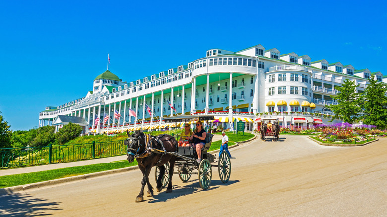
Anyone who has ever wanted to experience life the old-fashioned way should head to the car-free paradise of Mackinac Island, Michigan. Located on Lake Huron, this charming island has banned motorized vehicles since the turn of the century. Visitors get around via horse-drawn carriage, and the landscape is dotted with charming Victorian buildings and bright flower beds. Bicycles are also a popular form of transportation, thanks to a 8.2-mile path that winds along the island's scenic shoreline. Rent a bike, pack your basket with some of Mackinac Island's signature fudge, and pedal to the calm pebble beaches in the summertime. On especially warm days, cool off with a chilly dip in the Great Lakes.
Getting to Mackinac Island requires considerable planning. The nearest airport, Pellston Regional Airport, is a 20-minute drive from the port in Mackinaw City on the mainland. From there, travelers can catch a 16-minute ferry to the docks of Mackinac Island. However, anyone arriving from the Upper Peninsula might prefer to catch a ferry from the port of St. Ignace. Adult ferry tickets cost $38 roundtrip, and $26 for children between the ages of 5 and 12. The ferry runs seasonally from mid-April to late October. The Grand Hotel is most iconic place to spend the night, but there are other accommodations on the island as well. Alternatively, you may discover more budget-friendly choices in Mackinaw City.
Pictured Rocks National Lakeshore, Munising
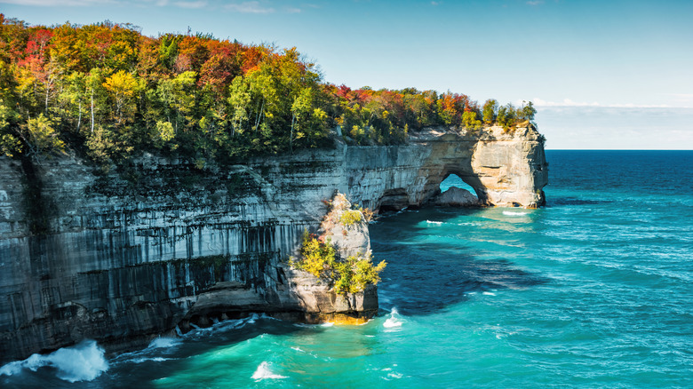
Travelers hunting for the best hikes in the Midwest need look no further. Located near the town of Munising on the northern edge of Michigan's Upper Peninsula, Pictured Rocks National Lakeshore offers scenic trails galore. This park encompasses 18 forested paths that wind along dramatic lakeside cliffs with spectacular views of Lake Superior. The trails cater to hikers of all skill levels. Families will love the Miner's Castle Overlook, a wheelchair-accessible path that allows visitors to marvel at a castle-shaped cliff. The North Country Scenic Trail, meanwhile, spans 42 miles of pristine coastline — inviting adventurers to experience Lake Superior for days at a time. Other trails lead to waterfalls, rushing rivers, and secret sandstone beaches.
Lodging near Pictured Rocks National Lakeshore is relatively sparse, so be sure to reserve your stay in advance. Many previous visitors to the park recommend camping directly on the premises, and it's no wonder why. The park's Twelvemile Beach Campground allows visitors to camp on a sandy plateau and wake up to the relaxing sound of the waves. Just keep in mind that the campground is only open from mid-May to mid-October. Tent camping costs $25 per night, and day passes to the park cost $25 per vehicle, at the time of writing. In the winter months, snowmobiles have access to discounted day passes for $15.
Boyne Mountain Resort, Boyne Falls
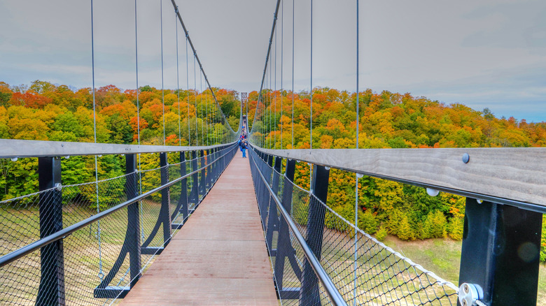
Michigan offers some fantastic ski resorts during the snowy months, but Boyne Mountain Resort in Boyne Falls offers incredible activities all year-round. During the summer, visitors can enjoy a refreshing hike to the top of the hill free of charge. Adrenaline lovers will enjoy the resort's Zipline Adventures, which allow you to zoom down the mountain at speeds of 25 miles per hour. Autumn is the best time to cross the SkyBridge, the longest timber-towered suspension bridge on Earth. Cross its incredible length and gaze out at the endless expanse of colorful foliage.
During the winter, Boyne Mountain Resort transforms into one of the top family-friendly ski destinations that are actually affordable. Single day lift passes start at $43 for adults and $32 for children between the ages of 6 and 17, at the time of writing. For more family-friendly fun, head to the indoor waterpark at the mountain's base, Avalanche Bay. Kept at a comfortable year-round temperature of 84 degrees Fahrenheit, the waterpark can be enjoyed on even the coldest winter days in Michigan. The resort is just an hour's drive from Traverse City, three hours from Grand Rapids, and four hours from Detroit.
Hartwick Pines State Park, Grayling
Back in the 1800s, Michigan's forests attracted a booming lumber industry that, sadly, resulted in rapid deforestation. To get a feel for what the state's woodlands once were, head to Hartwick Pines State Park in Grayline, Michigan. This impressive nature preserve features spectacular old-growth trees that have remained rooted for centuries. The oldest trees in the park have stood for approximately 400 years. In 1927, lumber industry heiress Karen Hartwick purchased 8,000 acres of forested land and donated it to the state, so that the majestic woodlands of Michigan could be preserved.
To witness the soaring trees at Hartwick Pines State Park, embark on one of its many walking trails. The 1.5-mile Old Growth Forest Trail is the best way to observe the oldest trees in the park. But, avid hikers and cross country skiers will be pleased to know that there are 21 miles of paths to explore in every season. Hartwick Pines State Park is accessible to Michigan locals via the $14 annually renewable state park passport. Non-residents can purchase an $11 day pass for their vehicle.
Traverse Wine Coast, Traverse City
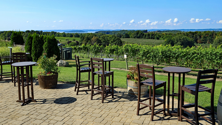
California may be known as the wine capital of the United States, but that doesn't mean that Michigan should be overlooked. The Traverse Wine Coast near Traverse City, Michigan is loaded with charming wineries where visitors can sip vino with a view. Nestled in the picturesque hills that line the shores of Lake Michigan, the region boasts rich soil and ideal grape-growing conditions shaped by centuries of glacial activity. Travelers can choose from over 40 different wineries to visit — many of these offer tasting flights of local specialties, such as riesling and pinot noir.
Although summer and fall are both popular times to visit the Traverse Wine Coast, the experience is wonderful year-round. During the winter, many visitors enjoy snowshoeing between vineyards, warming up with a glass at each stop. Every year in January, Chateau Chantal also holds an Ice Wine Festival, where visitors can learn how frozen grapes are pressed and transformed into a unique beverage called ice wine.
Begin your adventure in vibrant Traverse City, a beach-loving shoppers' paradise located in Northern Michigan. Many wine tours are offered in the region with transportation included. However, having your own set of wheels allows you to explore the Traverse Wine Coast at your own pace — with a designated driver, of course. Hotel prices in Traverse City vary considerably, but are often cheaper in the winter months.
Tahquamenon Falls State Park, Paradise
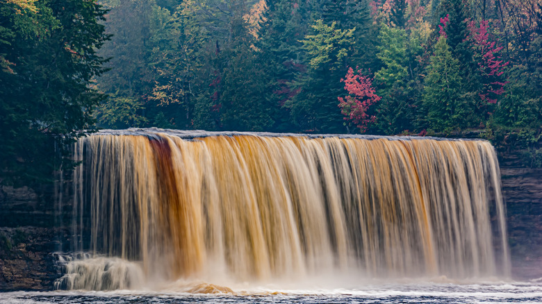
Tahquamenon Falls State Park is located in paradise — literally. This 50,000-acre ecological park in Paradise, Michigan does its name justice, thanks to the gorgeous natural beauty of the area. The coursing waters of the Tahquemenon River, deep green pine trees on the riverbank, and nature trails exude tranquility. The crown jewel of the park is its spectacular waterfalls. Divided into the impressive Upper Falls and picturesque Lower Falls, these waters embody the mystical beauty that feels innate to Michigan's northern woods. A new 900-foot wheelchair-accessible boardwalk allows visitors to observe the falls from above. The water has a distinct red color due to the tannins draining from the surrounding trees.
Hikers will adore the year-round adventures at this Michigan state park. During the summer and autumn, tackle the 4-mile linear trail that runs along the river between the waterfalls. In the winter, go snowmobiling, cross-country skiing, or on a guided snowshoeing excursion offered for free at the park. Even beer aficionados fall in love with this destination due to the artisanal brewery located on the premises.
To get to Tahquamenon Falls State Park, drive about two hours from Pellston Regional Airport, which services Detroit. To enjoy the park, Michigan residents require a $14 annual state park pass, and non-residents can buy a day pass for $11 per person. Overnight visitors can rent a cabin at Tahquamenon Falls State Park, or pitch a tent at one of the park's several campgrounds.
Methodology
Compiling this list of the best destinations in Michigan was an absolute joy. I have made yearly month-long trips to Michigan over the course of 25 years, exploring everything from Detroit's cultural centers to the forests of the Upper Peninsula. Decades of experience have allowed me to develop a keen understanding of the state's hidden gems and treasures. In addition to my own expertise and that of other locals, this guide includes the most renowned and highly-rated destinations in Michigan, amassing the greatest number of positive reviews on trusted platforms like Google Reviews and Tripadvisor.
This guide also reflects the diverse array of experiences that Michigan offers — for example, the Dutch gardens in Holland and the Detroit Institute of Arts in Detroit for their unique cultural offerings. Sleeping Bear Dunes National Lakeshore and Pictured Rocks National Lakeshore were selected for their spectacular views of the Great Lakes — the defining feature of Michigan's natural beauty. Mackinac Island and the shipwreck tours in Munising both provide a special glance into the region's past. Hartwick Pines State Park and Tahquamennon Falls State Park offer direct access to Michigan's unspoiled wilderness. Finally, the Traverse Wine Coast and Boyne Mountain Resort are known for their year-round appeal.