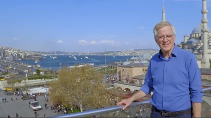
9 Top-Rated Hikes & Walks in Hong Kong

Written by Lana Law
Updated Apr 6, 2023
We may earn a commission from affiliate links ()

Hiking might not be the first thing that comes to mind when planning a trip to Hong Kong, but the trails here are outstanding, with phenomenal views and access to remote areas.

With 300 kilometres of dedicated hiking trails, you can find everything from paved walking paths through lush forest to rugged mountain-top trails and hikes that will take you from one remote village to the next. You can hike to beautiful stretches of lonely beaches, or find trails overlooking the forest of high-rises that dominates Central Hong Kong.

If you have time, take a day trip to one of Hong Kong's Outer Islands or the New Territories to get away from the city for a while. If you're pressed for time and have only a few hours, try a hike above the city, with views out over the harbor.

Hikes on Hong Kong Island & The New Territories

1. Dragon's Back Hike, Hong Kong Island

Dragon's Back Hike, Hong Kong Island
Dragon's Back Hike, Hong Kong Island | Photo Copyright: Lana Law

The Dragon's Back Hike is the most popular hiking trail in Hong Kong. It offers enchanting views over the rugged coast and beautiful beaches of Hong Kong Island that many visitors don't even know exist.

The trail ends at a popular beach, where you can stop for a well-earned swim and a bite to eat before returning to Central Hong Kong just a half-hour away.

This 8.5-kilometer hike takes between two and three hours to complete, depending on how busy the trail is on the day of your hike. Weekends and holidays can be crowded.

The Dragon's Back is a very convenient day hike if you are staying on Hong Kong Island, and can be reached by metro and bus, or a simple taxi ride.

The path follows a ridge, reaching 284 meters at the highest point, and then descends down through dense forest. From the ridge, you can gaze out over the lovely crescent-shaped Shek O Beach, and further on, the beach at Big Wave Bay. In the opposite direction, you can look out over a tranquil bay dotted with yachts.

Big Wave Bay Beach
Big Wave Bay Beach | Photo Copyright: Lana Law

This is a one-way hike that starts at a fairly high elevation and ends at the beach. The trail is primarily downhill, apart from a couple of uphill sections near the start.

Near the end of the hike, the trail splits, but if you stay right, you can follow the trail down to Big Wave Bay, where there is a glorious stretch of beach and some casual outdoor restaurants. Change rooms and other facilities are located at the beach, so be sure to bring your swimwear.

From Big Wave Bay, you can also take a bus or taxi for a quick trip over to Shek O Beach, another popular and larger beach with more dining options. You can also rent a beach chair and umbrella here if you want to lounge for a while.

2. The Peak Trail, Hong Kong Island

View over Hong Kong from Peak Trail
View over Hong Kong from Peak Trail | Photo Copyright: Lana Law

Most sightseers head up to The Peak (Victoria Peak) for the view from the observation deck or to enjoy a ride on the famous Peak Tram. But if you are looking for a great way to get some exercise and a nature fix, the Peak Trail is a scenic path at the top.

It runs along the mountainside, through lush forest, and offers some of the most inspiring views over Hong Kong and Kowloon. This is more of a nature walk than a hike, but if you are jet-lagged and not up for a big hike, this is the perfect alternative.

A section of the trail runs along the old Lugard Road. This engineering marvel from 1914 is a narrow road built on stilts, and today just a walking trail that hugs the cliffside and looks out over the harbor. This road has long been known as one of the most famous sightseeing trails in Hong Kong.

Just under three kilometers in length, this is a relatively flat, paved trail, shaded by lush foliage overhead. At a leisurely pace, this trail takes about 50 minutes. Scenic areas, particularly along the Lugard Road, are cleared, so you can enjoy the extensive views.

Since the trail circles around The Peak, the views are arguably more impressive from this trail than from the observation deck, and unlike the observation deck, the trail is free, and much less crowded.

A map at the trailhead shows the route and highlights. The start of the trail, if you are heading in a clockwise direction, has signs that say "Morning Trail" and this means you are on the right path. The forest is quite dense at the start before opening up into a park area with flowers and benches.

Beyond here, the trail has a number of scenic sections, and the scenery is always changing as you round the curve of the mountain. The most beautiful lookouts are near the end of the trail, so if you are short on time start in a counterclockwise direction and go as far as the Lugard Road, then return the same way.

The Peak Trail leaves from the front of The Peak Galleria, the main commercial plaza at the top of The Peak. Taxis will drop you at the base of The Peak Galleria. Take the escalator up one flight to the main plaza area, where the trail begins. If you are lost, check with the Concierge in The Peak Galleria.

Hiking Down from the Peak

Hiking Down from the Peak
Hiking Down from the Peak | Photo Copyright: Lana Law

If you want to extend your walk, you can also hike up or down The Peak on pathways, ducking out onto very low traffic roads here and there. This route, known as the Central Green Trail, can be confusing going up but easier to follow going down.

If you are at the main plaza in front of The Peak Galleria, follow Findlay Road in the opposite direction of The Peak Trail. This is a paved walking trail leading down the hill. Again, this trail is shade-covered but gets hotter as you descend the mountain.

Confusion comes when the trail dead ends on Barker Road. You can turn right or left at this point. If you stay to the right, following Barker Road a short distance, you will eventually see a sign for Chatham Path, and a set of stairs descending the hill.

Chatham Path is the nicest stretch of trail on the route down the hill. It vaguely follows the Peak Tram tracks, which you can see at various points along the route, and eventually leads you back to the city streets, where you can catch a cab or continue walking. Using a GPS can help you navigate the route down, but signs along the way help guide you.

If you still have energy left at this point, you can wander through Hong Kong Park, right across from the entrance to the Peak Tram. This is a beautiful green space and a free attraction. The walk-through aviary is wonderful.

3. Monkey Trail Hike (Shing Mun Reservoir Hike)

Monkeys at the Shing Mun Reservoir

For an outing that gets you up close and personal with wildlife, head to Shing Mun Country Park.

As soon as you arrive, you will most likely be greeted by troops of Rhesus Macaques. It's worth reading the signs that provide clear direction on how to deal with these furry marauders. They are natural actors and more than happy to pose for pictures.

A number of hikes are spread throughout the park, but the easiest and most popular is the one to the reservoir. The 3.4-kilometer trail is easy, and the walk across the dam is worth experiencing. For a bit more distance and exercise, consider walking to the top of the hill, nicknamed Monkey Hill.

To access the park, take the MTR to Tsuen Wan station and take exit B1. Walk a short distance to catch minibus #82, and get off at the park entrance.

4. Tai Long Wan (Maclehose Trail, stage 2)

Tai Long Wan (Maclehose Trail, stage 2)

For a longer and more challenging hike, with fantastic views and beautiful beaches, try the Tai Long Wan hiking trail. This fabulous 12-kilometer stretch of the Maclehose Trail (Stage 2), is remote by Hong Kong standards, and offers outstanding scenery of lush mountains and coves with soft-sand beaches. It's often described as one of the most beautiful natural areas in Hong Kong.

This hike requires some heart-pounding ascents before descending to a series of beaches along the three-kilometer-wide bay of Tai Long Wan. You can enjoy the views from the high ridges and then take a dip to cool down when you reach the shoreline.

This is an out-and-back hike, and it takes at least half a day. Depending on where you are beginning your day, plan on a full day for this outing. The Tai Long Wan hike is located on the Sai Kung Peninsula in the New Territories.

Getting here can take some time and planning. The main town in the area is Sai Kung, accessible by MTR. From here, there are several options to access the start of the hike, including a bus or a green taxi.

If you want to stay in the area to get an early start on this hike, the Pak Sha O Youth Hostel is located right in Sai Kung. Better options can be found about 20 minutes away by car. Some good choices include the Hyatt Regency and the Courtyard Hong Kong, both in nearby Sha Tin. Alternatively, you can commute from Kowloon, which will add another 10 to 15 minutes, if there are no traffic delays.

5. Ping Shan Heritage Trail

Pagoda on the Ping Shan Heritage Trail

If culture is more your thing instead of nature, and you love hiking, the Tai Ping Shan Heritage Trail will check all the boxes for you.

Ideal for families, this trail is easy and only one kilometer long. Along the way, you'll pass historical buildings belonging to the Tang clan dating from the 13th century. Highlights include Tang Clan Ancestral Hall, dating from 1273, and the oldest pagoda in Hong Kong, Tsui Sing Lau, dating from 1486.

A visitor center located in the Old Ping Shan Police Station is at the start of the walk and provides maps and further information.

To get here, just take the MTR to Tin Shui Wai Station. Use exit E3 and follow the signs.

Hikes on Lamma Island

Trail to Tung O Beach
Trail to Tung O Beach | Photo Copyright: Lana Law

Just a half-hour ferry ride from Central Hong Kong, Lamma Island offers some of the most enjoyable hiking and walking trails in Hong Kong. The island has no cars or roads, but paved trails through the mountainous island connect the villages and lead to beautiful high lookout points and lovely stretches of golden-sand beaches.

Trails have some decent elevation gain and loss but are relatively easy and, for the most part, well signposted.

The most popular hike on the island is from the village of Sok Kwu Wan to Yung Shue Wan, which can be done in either direction. Ferries from Hong Kong Island service both towns, and most people plan to arrive in one village and depart from the other. Both towns have restaurants and shops. Sok Kwu Wan has a row of simple waterfront restaurants that overlook the small harbor.

Yung Shue Wan is a quaint village, with an almost Mediterranean feel. Waterfront restaurants here have a slightly more upscale feel to them than those in Sok Kwu Wan, and the town has more small shops to wander through.

6. Sok Kwu Wan to Yung Shue Wan Hike

Hike from Sok Kwu Wan to Yung Shue Wan
Hike from Sok Kwu Wan to Yung Shue Wan | Photo Copyright: Lana Law

A nice way to spend the day on Lamma Island is to arrive in Sok Kwu Wan and hike the four-kilometer scenic path to Yung Shue Wan, stopping just a few minutes before the end of the trail to go for a swim at Hung Shing Yeh Beach.

End the hike with lunch in Yung Shue Wan before catching a ferry back to Hong Kong. This scenic trail is easy and offers a glimpse of the island's villages.

Near the start of the trail is a well-marked cave, known as the Kamikaze Caves, where it is believed the Japanese hid boats used to ambush and attack allied ships during WWII.

Beyond here, head inland and cross over to the far shore, where you'll find beautiful views all along the mountainside, over the coast, and out to sea. Eventually, the trail opens up to a view of Lamma's huge power plant, which is a bit of a distraction, but interesting nonetheless.

Just before the power plant, the trail descends down to Hung Shing Yeh Beach, where there are changing rooms and a few restaurants. Beyond the beach, the trail passes through a couple of villages and then drains into the narrow streets of Yung Shue Wan, lined with restaurants, souvenir sellers, and vegetable stalls.

If you want to stay the night on Lamma Island the Concerto Inn in Yung Shue Wan offers decent rooms at a very reasonable rate. Breakfast is included.

This is a great way to turn a day trip into a nice weekend getaway, and it will give you time to do a couple of hikes, spend time at the beach, and soak up the atmosphere in Yung Shue Wan.

7. Hike to Tung O Beach

View from pagoda on hike to Tung O Beach
View from pagoda on hike to Tung O Beach | Photo Copyright: Lana Law

If you are looking for a longer day of hiking, add on a hike to Tung O Beach from Sok Kwu Wan. This trail heads inland, up and over a high ridge to a scenic lookout point. At the saddle of the ridge, a lookout trail leads off to the right to a pagoda. It's worth walking up here for the spectacular view over the rugged coastline on the far side of the island.

The trail then descends steeply down the back side. Keep left at the Y junction. From here, the trail will lead to Tung O Village and just beyond to the expansive crescent-shaped beach. This is a remote beach with no development and often, no people.

You can either hike in and out to Tung O Beach, which will take about an hour, or do a loop that runs through Mo Tat Wan and returns to Sok Kwu Wan, for a total hiking time of about 2.5 hours. This is an incredibly scenic loop and is much less busy than the hike to Yung Shue Wan.

It's also more strenuous, with more ups and downs, but you will likely have the trail to yourself most of the way. Once back at Sok Kwu Wan, take a break, and then continue on to Yung Shue Wan.

Hiking Details

From the Sok Kwu Wan ferry terminal, walk to the right, past the restaurants and an open concrete square on First Street. At the end of the concrete square are two trails. The one to Yung Shue Wan is on the right and follows the waterfront.

The trail just to the left heads up and inland over to Tung O. If you don't have a map with you but have your phone or camera, take a quick snap of the island map at the ferry dock. Intersecting trails can be a bit confusing if you have no reference to follow.

Hikes on Other Outlying Islands

8. Lantau Peak Hike

Lantau Peak Hike
Lantau Peak Hike

At 934 meters, Lantau Peak is the second highest peak in Hong Kong and the highest accessible summit. For perspective, Shek O Peak on the Dragon's Back hike reaches a height of 284 meters.

The view from Lantau Peak does not disappoint, with a fantastic panorama of the entire surrounding area, over the mountains and ocean. Many people do this hike in the early morning, reaching the summit for sunrise. The hike to the peak takes about two hours, so you need to depart at around 4am to be at the top for sunrise.

If you are not a morning person, don't despair. This hike is awesome at any time of day and well worth doing even if you choose to sleep in. The total time for this 4.5-kilometer hike is about 2.5 to three hours, and it ends at Lantau's famous Big Buddha. This is Stage 3 of the Lantau Trail.

From the Tung Chung MTR station, you can catch a bus (3 or 3M) to Pak Kung Au, the start of the trail. At the end of the hike, you can spend some time wandering around the Big Buddha, grab some lunch at the commercial center at the base of the Buddha, and then take a bus or the Cable Car down to an MTR station.

9. Po Toi County Trail

Po Toi County Trail
Po Toi County Trail

For a full-day outing consider heading to the island of Po Toi. A four-kilometer loop trail, called the Po Toi County trail, leaves right from the ferry terminal and takes you up high to the Nam Kok Tsui lighthouse for spectacular views out across the ocean.

Along the way, you'll pass by bizarre geological rock formations. One of the formations is said to look like a giant palm tree; another is said to look like a tortoise climbing the hill. Also found on this trail are rock carvings, estimated to be over 3,000 years old.

If you've never tried dried seaweed, Po Toi island is renowned for this delicacy — enjoy some with a cold drink at the end of your hike.

To get to the trailhead, you'll need to take a small ferry called a kaito, from Aberdeen Pier to Po Toi Pier. You can also leave from Stanley Pier. The one-way trip takes about 1.5 hours and is quite scenic. Camping is permitted at the lighthouse.

Map of Hikes & Walks in Hong Kong

Hong Kong - Climate Chart

Average minimum and maximum temperatures for Hong Kong, China in °C
JFMAMJJASOND
19 14 19 15 22 17 25 21 28 24 30 26 32 27 32 27 31 26 28 24 24 19 21 16
Average monthly precipitation totals for Hong Kong, China in mm.
28 43 74 140 285 399 363 376 297 119 38 25
Average minimum and maximum temperatures for Hong Kong, China in °F
JFMAMJJASOND
67 58 67 59 71 63 77 69 83 75 86 79 89 81 89 81 87 79 83 75 76 67 70 60
Average monthly precipitation totals for Hong Kong, China in inches.
1.1 1.7 2.9 5.5 11 16 14 15 12 4.7 1.5 1.0