16 Top-Rated Attractions & Things to Do in Tasmania
For those who haven't visited Australia's smallest state, Tasmania or "Tassie," seems shrouded in mystique. Perhaps it's the state's far-flung location, some 300 kilometers south of the Australian mainland across stormy Bass Strait. Maybe it's the vast expanses of windswept wilderness. Almost half of Tasmania's land mass lies in national parks and World Heritage Areas, with sparkling alpine lakes, wild rivers, and mist-cloaked peaks.
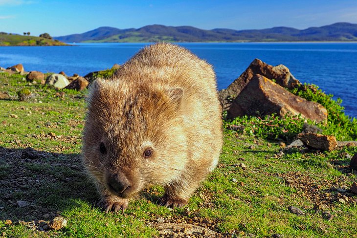
Perhaps it's the bizarre wildlife – from real life Tasmanian devils to the extinct thylacine, the Tasmanian tiger. Or is it the haunting convict history and beautifully preserved heritage towns, which seem frozen in time? Today, this mystique lures more and more tourists who are discovering the island's many jewels.
Shaped appropriately like a heart, Tasmania is also a foodie's delight. Gloriously creamy cheeses, crisp fruits, and succulent seafood are just some of the mouthwatering local treats on offer, and hanging out at a waterfront café or restaurant is one of the top things to do in the port city of Hobart.
If you're looking for a unique way to arrive on the island, you can travel from Melbourne to Devonport by sea on the Spirit of Tasmania. Best of all, you can bring your car with you. If you choose this option, check out a Tasmania attractions map, and plot a scenic road-trip.
Explore this enchanting state with our list of the top attractions and things to do in Tasmania.
See also: Where to Stay in Tasmania
- 1. Explore Cradle Mountain-Lake St. Clair National Park
- 2. Get a Culture Fix in Hobart
- 3. Port Arthur Historic Site
- 4. Hike through Freycinet National Park
- 5. See the Views from kunanyi/Mount Wellington
- 6. Tasman National Park
- 7. Walk the Three Capes Track
- 8. Cataract Gorge, Launceston
- 9. Stroll around Salamanca Place
- 10. Visit Bruny Island
- 11. Mona Museum and Art Gallery
- 12. Mount Field National Park
- 13. Franklin-Gordon Wild Rivers National Park
- 14. Marvel at the Scenery on Maria Island
- 15. Richmond
- 16. Climb The Nut
- Where to Stay in Tasmania for Sightseeing
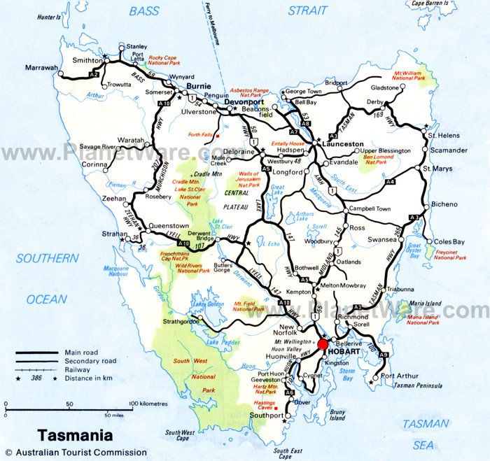
- Map of Attractions & Things to Do in Tasmania
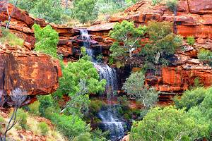
1. Explore Cradle Mountain-Lake St. Clair National Park

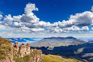
In the north of the Tasmanian Wilderness World Heritage Area, Cradle Mountain-Lake St. Clair National Park is the jewel in the crown of the state's many natural wonders. Glacier-carved crags; glittering lakes; beech forests; alpine heathland; and jagged dolerite peaks, including 1,616-meter-high Mount Ossa (the highest point on the island), are some of its most breathtaking features.
Hiking in Cradle Mountain-Lake St. Clair National Park is legendary. Favorite day walks include the Lake Dove Walk, with magnificent views of Cradle Mountain (1,545 meters), and the Weindorfer Walk, a six-kilometer circuit through dense forests. If you're wondering what to do in Tasmania for a week, a hiking trip here could more than fill your days.
The northern part of Cradle Mountain-Lake St. Clair National Park, is particularly beautiful. From the summit of Cradle Mountain, you can enjoy breathtaking views of the central highlands. The famous 80-kilometer Overland Track runs south from Cradle Valley to stunning Lake St. Clair, the deepest lake in Australia.
Official site: http://www.parks.tas.gov.au/indeX.aspX?base=3297
2. Get a Culture Fix in Hobart
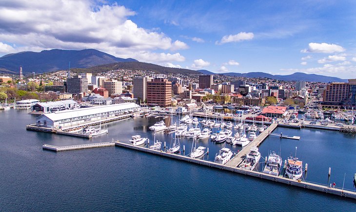
Tasmania's capital has transformed itself from a sleepy backwater with a turbulent convict history to a hub of cutting-edge culture. Its beautiful setting between the sea and the soaring peak of kunanyi/Mount Wellington has, no doubt, inspired many of its talented artists in all genres.
Opened in 2011, MONA: Museum of Old and New Art pushes the art world envelope with its provocative and confronting exhibits, while the Tasmanian Museum and Art Gallery takes a more traditional look at the country's art, as well as its natural history.
Foodies will also find plenty to smile about. The city's waterfront precinct buzzes with hip cafés and restaurants, and you can eat around the world on the restaurant strip in North Hobart.
Delving into the city's rich convict history is another one of the top things to do in Hobart. Visit the Hobart Convict Penitentiary, and explore the historic sandstone warehouses at Salamanca Place, now filled with shops, cafés, and antique dealers. From here, you can also follow the Battery Point Sculpture Trail to see elegant convict-built architecture.
Natural attractions are also never far away from the city buzz. Climb kunanyi/Mount Wellington to really appreciate Hobart's picturesque setting, and gaze out at the World Heritage wilderness in the distance.
Read More: Best Tourist Attractions in Hobart
3. Port Arthur Historic Site
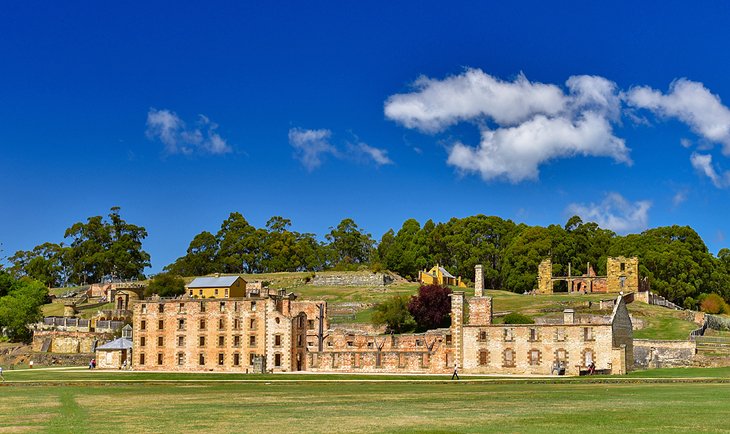
The old convict settlement of Port Arthur offers a sobering look at Tasmania's turbulent past. About an hour's drive southeast of Hobart, the ruins are part of the Australian Convict Sites World Heritage Property. Here, in 1830, Governor Sir George Arthur established a brutal penal settlement where convicts were forced to hew coal in the mines and fell timber.
In spite of a devastating fire in 1897, the remains of many buildings still stand, including the guard tower, church, model prison, and hospital. You can also browse fascinating documents and relics of the penal settlement in the museum, or visit the nearby Coal Mines Historic Site. Admission tickets give you two days to explore all the attractions here, and they also include an introductory walking tour and 25-minute harbor cruise.
Looking for unique things to do in Tasmania? Consider joining an evening lantern-lit "ghost tour" of the ruins.
After touring Port Arthur, take a drive along the coast to explore the soaring sea cliffs and sheltered coves of the spectacular Tasman peninsula.
Address: 6973 Arthur Hwy, Port Arthur, Tasmania
Official site: http://portarthur.org.au/
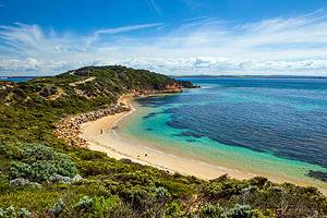
4. Hike through Freycinet National Park
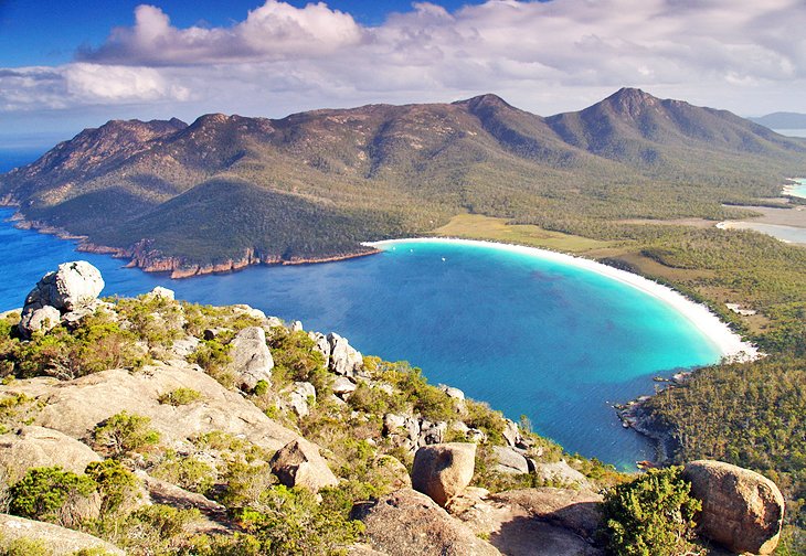
World Heritage-listed Freycinet National Park, on Tasmania's relatively sunny east coast, is one of Australia's oldest nature reserves and one of its most beautiful. Hiking the many scenic trails here is the best way to explore the park.
The star of this picturesque peninsula is the perfect curve of powder-white sand and azure sea at Wineglass Bay – one of the top beaches in Australia. Wander through pristine bushland to secluded bays and lookouts, or tackle the Wineglass Bay Circuit, one of Australia's top hikes. Along the way, keep a look out for some of the many birds in the park. Black cockatoos, kookaburras, and sea birds are just some of the resident species.
Take the 20-minute walk from the lookout to the southern end of Wineglass Bay to admire beautiful views of the Hazards, three striking pink granite crags rising out of the sea. The peaks are best photographed at sunrise and sunset when their color deepens in the golden light.
At the entrance to Freycinet National Park, the little beach resort of Coles Bay is a good base for walks and climbs in the surrounding hills, and you can also explore the entire region on the East Coast Escape scenic drive.
Official site: http://www.parks.tas.gov.au/indeX.aspX?base=3363
5. See the Views from kunanyi/Mount Wellington
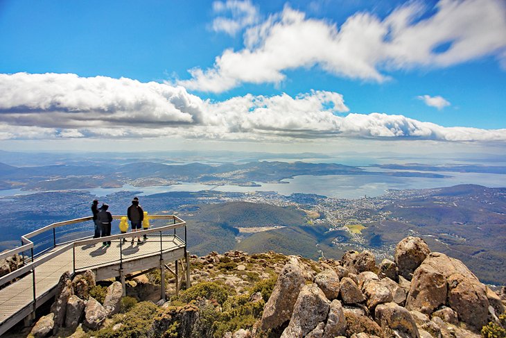
Undulating to the west of Hobart, the comforting presence of 1,270-meter-high kunanyi/Mount Wellington is a constant reminder of the unspoiled wilderness that lies on the doorstep of this waterfront capital.
Follow a winding 21-kilometer mountain road to the Pinnacle, often sprinkled with snow, for breathtaking views over Hobart, the Derwent Valley, and the D'Entrecasteaux Channel. At the summit, boardwalks lead to panoramic viewpoints, and a pavilion displays old photographs of Hobart and Mount Wellington.
The mountain is a popular spot for biking and hiking through the temperate rain forests, and the distinctive Organ Pipes, a dolerite cliff, is renowned for its excellent rock climbing. Standing atop the summit and admiring the sweeping views is one of the best free things to do in Tasmania, but dress warmly as the weather here is notoriously fickle.
Official site: http://www.wellingtonpark.org.au/
6. Tasman National Park
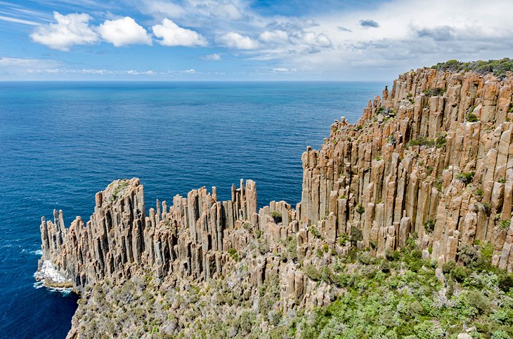
On the wind-lashed Tasman Peninsula, 56 kilometers east of Hobart, Tasman National Park protects some of Australia's most spectacular coastal scenery. If you look at a map of Tasmania, this park cloaks the far southeast tip of the state, with nothing but ocean between here and Antarctica.
It's a place of raw beauty. Towering dolerite cliffs plunge 300 meters to the sea, islands shimmer just offshore, waterfalls tumble to the sea, and contorted rock formations wear the relentless forces of wind and water.
The Blowhole and Tasman Arch are two of the park's most famous features. Other top sites include Remarkable Cave, Waterfall Bay, and the Devil's Kitchen – a collapsed rock arch.
Wildlife also scores top billing here. Apart from many species of rare birds, the area plays host to Australian fur seals, dolphins, whales, fairy penguins, and possums. A popular way to explore this stunning national park is by hiking the Three Capes Track (see below).
You can also explore some of the top attractions by car, or hop aboard a boat to glimpse the soaring cliffs from sea level, or cast a line – fishing can be excellent here. In the southern end of the park, climbers scale the dolerite cliffs, and Pirate's Bay is popular with hang-gliders.
Nearby lies the World Heritage-listed Port Arthur, one of Australia's most poignant historic sites.
Official site: http://www.parks.tas.gov.au/indeX.aspX?base=3868
7. Walk the Three Capes Track
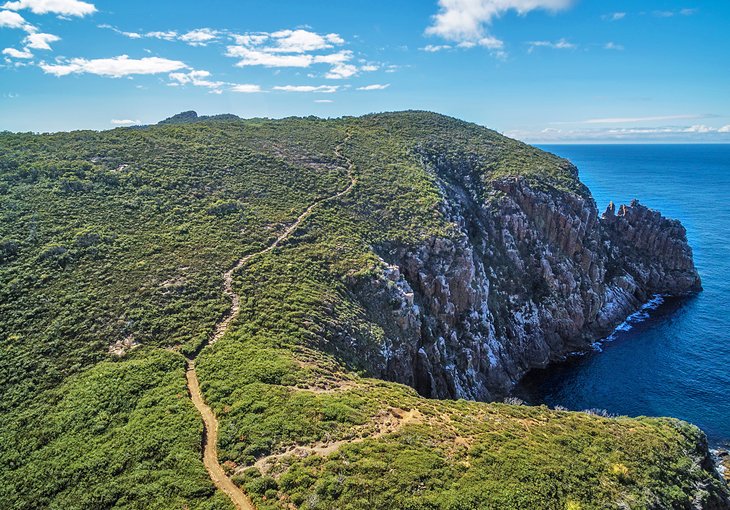
Starting and ending in World Heritage-listed Port Arthur, the stunningly scenic Three Capes Track slices through more than 48 kilometers of awe-inspiring wilderness in Tasman National Park. A boat delivers you to the trailhead from Port Arthur, where you'll walk along the edge of the continent, with breathtaking views of the Tasman Sea from the cliff-top trail.
Along the way, you'll walk through pristine eucalyptus forests and windswept heathland; see spectacular dolerite columns rising from the sea; encounter wildlife like wombats, wallabies, and echidnas; and stay in comfy eco-friendly cabins.
Every hiker receives a guidebook with maps and notes about the journey, as well as stories to read as they sit on strategically placed benches along the track. This four-day, three-night hike is suitable for all levels of hikers – even children. It's one of the best things to do in Tasmania in spring, fall, or summer, although hardy hikers could also tackle it in winter if they dress appropriately.
Official site: https://www.threecapestrack.com.au/experience.html
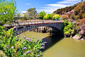
8. Cataract Gorge, Launceston
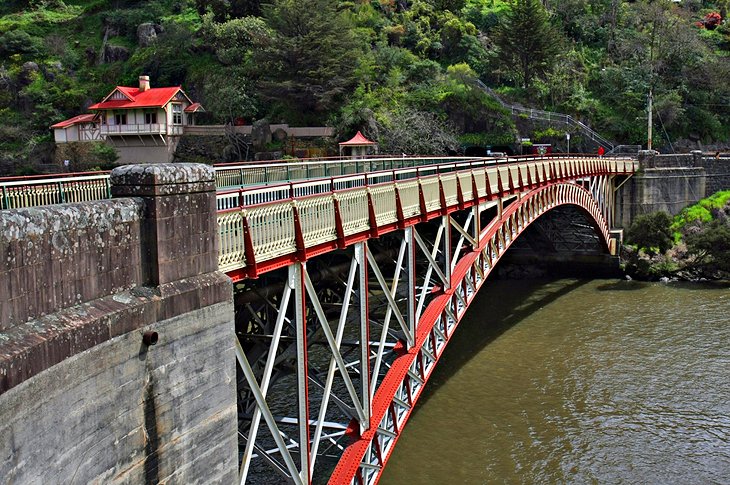
A mere 15-minute stroll along the river from Launceston's city center, the wild and romantic Cataract Gorge is a deep chasm carved over many centuries by the South Esk River. Offering striking scenery, the gorge is one of the top attractions in Launceston.
Precipitous walking paths, first built in the 1890s, cut into the cliff face on both sides of the gorge, offering heart-stopping views of the river far below.
The less adventurous can hop aboard the world's longest single-span chairlift, and the Kings Bridge and Gorge Restaurant also afford fine views. On the south side, you can relax at a café and paddle in the bush-fringed swimming pool.
At Cliff Grounds on the northern side, lies a beautiful Victorian garden replete with ferns, strutting peacocks, and wallabies. River cruises offer another perspective of this popular attraction.
If you're looking for things to do in Northern Tasmania, Cataract Gorge deserves a spot on your travel itinerary.
Official site: http://www.launcestoncataractgorge.com.au/
9. Stroll around Salamanca Place
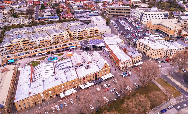
Salamanca Place, with its lovingly restored sandstone buildings, is a tourist hub in the heart of Hobart's historic waterfront. Built by convicts between 1835 and 1860, these beautiful Georgian buildings were once warehouses along the commercial center of old Hobart. Today, they house art galleries, cafés, restaurants, and shops.
You can dine alfresco along this cobblestone strip; shop for antiques and souvenirs; or visit the galleries, performing arts venues, and ateliers of the Salamanca Arts Centre. Every Saturday, tourists and locals alike flock to the Salamanca Markets, where more than 300 vendors sell everything from handcrafted jewelry and woodwork to fresh produce.
Nearby Constitution Dock is a favorite spot to buy fresh seafood, and one of the most popular things to do in December here is watch the yachts cruise in after the iconic Sydney to Hobart Yacht Race.
From Salamanca Place, you can also descend Kelly Steps to Battery Point, a picturesque seaside suburb with heritage houses.
10. Visit Bruny Island

About 55 minutes from Hobart by car and ferry, Bruny Island is a popular day trip from the city for foodies and nature buffs. The island lies across the D'Entrecasteaux Channel from the seaside town of Kettering. It's famous for its delectable gastronomic treats, such as handmade chocolates, local berries, artisan cheeses, and succulent seafood, which you can sample on island tasting tours.
South Bruny National Park, on the island's southern tip, offers beautiful coastal scenery, with soaring green sea cliffs, sheltered beaches, and challenging surf breaks.
You can explore the park on an eco-cruise or hike the many nature trails. Keep an eye out for wildlife. Fur seals and fairy penguins swim offshore, and wombats, wallabies, and echidnas are often spotted on land. Built by convicts between 1836 and 1838, Cape Bruny Lighthouse offers beautiful views of the surging Southern Ocean.
11. Mona Museum and Art Gallery
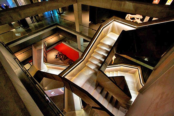
Cutting edge and controversial, the MONA (Museum of Old and New Art) in Hobart made a splash on the Aussie art scene when it opened in 2011. Its Tasmanian owner, David Walsh, described the thought-provoking collection of art and antiquities as a "subversive adult Disneyland."
After entering the museum's foyer at ground level, art lovers descend a spiral staircase to a subterranean gallery, where exhibits range from Sidney Nolan's Snake to an Egyptian sarcophagus and a machine that turns food into brown sludge. Portable touch screen devices provide commentary on the works.
Also on-site are entertainment venues, a trendy restaurant, library, cinema, and accommodation pavilions. The most popular way to travel to MONA is a 30-minute ferry ride along the Derwent River, which drops you off directly at the museum's steps.
Note that you need to buy tickets in advance. Check the website for details and opening hours.
Address: 655 Main Road, Berriedale, Hobart, Tasmania
Official site: http://www.mona.net.au/
12. Mount Field National Park
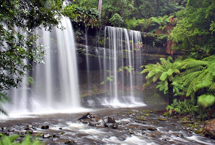
About 80 kilometers from Hobart, Mount Field is one of Australia's oldest national parks. Here, you can explore magnificent rainforests, tall swamp gums, alpine moorland, and stunning waterfalls.
Beautiful walking trails wind throughout the park, which is often dusted with snow in the high moorlands until summer. The short Russell Falls Nature Walk to these triple-tiered cascades is suitable even for wheelchair-users. You can also hike around Lake Dobson, and experienced bushwalkers have a choice of more challenging routes.
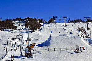
One of the popular things to do in Tasmania in winter is cross-country skiing, and this is an ideal place to indulge, only a 90-minute drive from Hobart. In the fall, the park ignites with yellow, orange, and red-leafed trees. This is also the site where the last Tasmanian tiger was captured in 1930.
Official site: http://www.parks.tas.gov.au/indeX.aspX?base=3589
13. Franklin-Gordon Wild Rivers National Park
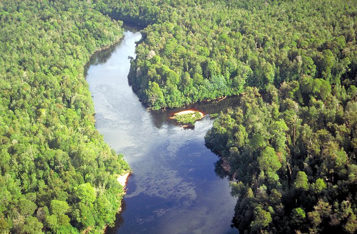
A UNESCO World Heritage Site, the spectacular Franklin-Gordon Wild Rivers National Park has become a symbol of one of Australia's most famous conservation victories. In the 1970s and 80s, this majestic mountain region of primeval rainforest, steep gorges, and wild rivers was the subject of bitter controversy over a proposal to dam the Franklin River. The opponents of the scheme, with their battle cry "No dams!" were victorious, and the wild beauty of the Franklin River and its surrounding wilderness remains.
Today, the national park is the nucleus of the Tasmanian Wilderness World Heritage Area, which also includes the rocky 1,443-meter peak of Frenchman's Cap. Its Aboriginal sites are evidence of a rich Indigenous heritage stretching back more than 36,000 years.
White-water rafting enthusiasts come here to tackle the tumultuous Franklin River, one of the top outdoor adventures in Australia, and hikers enjoy the short walks. A highlight is Donaghys Lookout Walk. You can also explore the park by car on the Lyell Highway. Better still, hop aboard a river cruise from the west coast village of Strahan.
Official site: http://www.parks.tas.gov.au/indeX.aspX?base=3937
14. Marvel at the Scenery on Maria Island
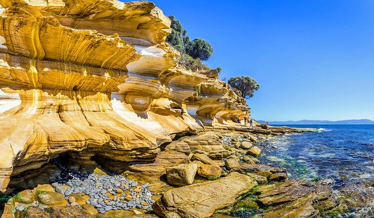
In a land of wilderness escapes, Maria Island truly stands out. Sitting off the east coast of Tasmania, this pristine, car-free island is a nature-lover's Eden. Among the top tourist attractions are the island's Painted Cliffs. Etched with russet-hued swirls of sediment, the Painted cliffs are a favorite subject for photographers. But you can also explore rugged mountains; wild, windswept beaches; fossil-flecked limestone cliffs; and dense forests.
Are you an animal lover? You'll find plenty of wildlife to ogle here, too, from wombats and wallabies to Tasmanian devils, ringtail possums, pademelons, and potoroos (small marsupials). Maria Island is also one of the top places to visit in Tasmania for bird-watching.
Other popular things to do on Maria Island include hiking the scenic trails, biking around the island, snorkeling and diving (if you can brave the cold waters), and exploring the area's rich history. While you're here, you can visit World Heritage-listed convict sites and learn about the Indigenous Puthikwilayti people, custodians of the land and surrounding waters for more than 40,000 years.
Want to stay overnight? Maria Island accommodation is limited. You can stay in basic bunks at the Penitentiary in Darlington, or pitch your tent in a campsite. But most visitors come here on day trips from Hobart.
If you're traveling here on your own, the ferry ride from Triabunna to Darlington, the island's main settlement, takes about 45 minutes. You won't find any shops here, so you'll need to bring everything you need with you, and pack it all out.
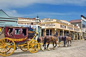
15. Richmond
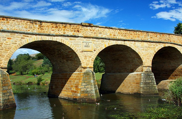
About 25 kilometers northeast of Hobart, Richmond is a kind of living open-air museum. Of all the early settlements in Tasmania, it presents the most complete and homogeneous picture of a Georgian colonial town. It was founded soon after the landing of the first settlers in Risdon Cove in 1803 and soon developed into the commercial center of a very fertile grain-growing district.
Richmond was also an important military post. Inmates from the town's penal colony constructed many of the buildings, as well as the Richmond Bridge, which dates from 1825 and is the oldest bridge in Australia.
Often seen in the background of bridge photos is the timber-topped St. Luke's Church, with beautiful stained-glass windows. It was so well constructed that the convict carpenter responsible was pardoned. A short distance to the north, the neo-Gothic St. John's Church, dating from 1837-59 is the oldest Roman Catholic Church in Australia.
Other historic highlights include Richmond Gaol and the well-preserved heritage buildings of Bridge Street. Traveling with kids? One of the top Tasmania attractions for families, the Old Hobart Town model village recreates life in the 1820s.
Many day trips to Richmond from Hobart also include a visit to Bonorong Wildlife Park in Brighton, where you can get up close to favorite Aussie animals like kangaroos, koalas, wombats, and Tasmanian devils.
16. Climb The Nut
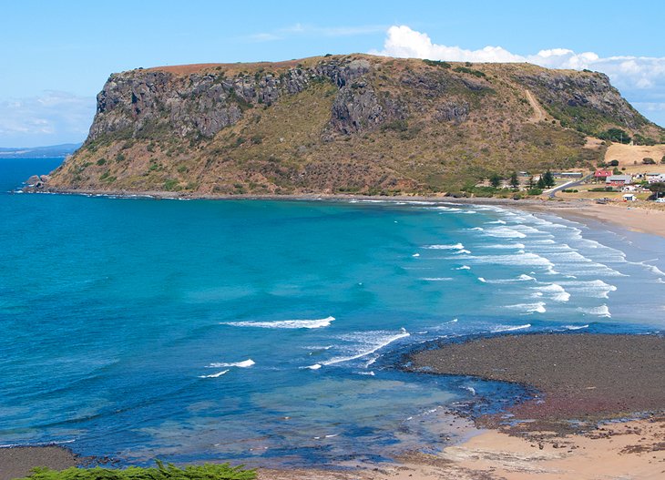
On Tasmania's northwest coast, the Nut is a 143-meter-high volcanic plug, which looms over the picturesque heritage town of Stanley. Matthew Flinders, who viewed it in 1798, thought it was reminiscent of a Christmas cake with its steep, rounded sides and flat top.
You can climb the steep path to the Pinnacle, which takes about 15 minutes, or hop aboard a chairlift for fantastic photo opportunities. At the top, trails of varying lengths lead visitors through fern-fringed forests and to scenic lookouts with 360-degree views of the curving coastline, the quaint hamlet of Stanley, and surrounding farmland. Look for pademelons and wallabies along the trails, and take a jacket, as the top can be quite windy.
Where to Stay in Tasmania for Sightseeing
We recommend these wonderful hotels in Tasmania's top tourist spots:
- Saffire Freycinet is a luxury eco-hotel on the Freycinet Peninsula, with spectacular views and floor-to-ceiling glass-encased rooms.
- The mid-range Grand Chancellor Hotel Hobart is in a great location, with harbor views, a pillow menu, and a fantastic restaurant.
- Salamanca Inn is a family-friendly all-suite hotel on Hobart's waterfront, steps from Salamanca Place. Choose from one- or two-bedroom suites with full kitchens.
- About a 10-minute walk from Cataract Gorge and Launceston's CBD, The Mews Motel is a budget hotel in a heritage building. Chat with the friendly management, cook your own meals in the well-equipped outdoor kitchen, then snuggle into a comfy bed at this home away from home.
Map of Attractions & Things to Do in Tasmania