13 Top-Rated Tourist Attractions on the Mornington Peninsula
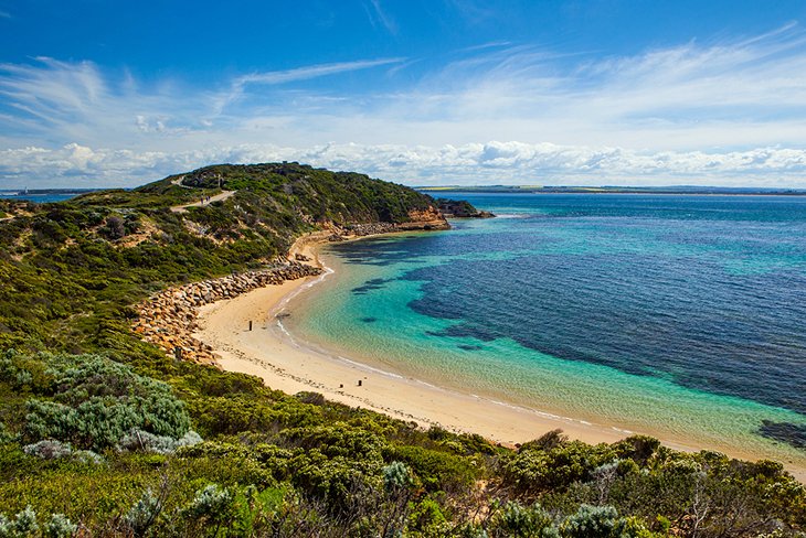
A summertime playground for Melburnians, a 90-minute drive from Melbourne, the Mornington Peninsula is beautiful in any season. With the ocean on one side and Port Phillip Bay on the other, this thin strip of prime real estate offers visitors the best of everything. Rugged coastal vistas, quiet coves lined with pretty wooden bathing boxes, charming seaside villages, and family-friendly parks and gardens are some of the region's many tourist attractions.
A car is the best way to explore the region, but once you're here, you'll find plenty of other ways to get around, from hiking and biking to boat trips and horseback rides. Other popular things to do include swimming with dolphins, fishing, golfing, and soaking in Mornington Peninsula hot springs. No wonder this picturesque region is one of the most popular weekend getaways from Melbourne.
Plan your trip with our list of the top attractions on the Mornington Peninsula.
- 1. Sorrento
- 2. Mornington Peninsula National Park
- 3. Peninsula Hot Springs
- 4. Back Beach Walks
- 5. Point Nepean National Park
- 6. Dolphin and Seal Swim
- 7. Horseback Riding along the Beach
- 8. Sorrento to Queenscliff Ferry
- 9. Arthurs Seat Eagle
- 10. Enchanted Adventure Garden
- 11. Ashcombe Maze
- 12. Red Hill Community Market
- 13. Art Galleries
- Where to Stay in the Mornington Peninsula for Sightseeing
- Map of Tourist Attractions on the Mornington Peninsula
1. Sorrento
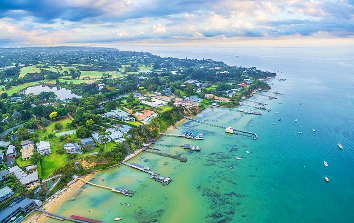
The site of Victoria's first mainland European settlement, Sorrento has always been considered one of Victoria's most fashionable towns. The graves of the first settlers can be seen at Sullivan's Bay, a particularly beautiful spot at dawn. Within the small township and surroundings, many of the magnificent local limestone buildings, built in the 1800s, still stand today and are protected under the National Trust.
Beautiful beaches are one of the town's top draws, and the main street and beachfront is lined with high-end fashion shops, restaurants, and cafés. There is even a cinema—The Athenaeum with a history that dates back to 1894.
To explore one of the best spots on the Mornington Peninsula, take the five-kilometer walking trail between Sorrento and Portsea (locally known as Millionaire's Walk). It skirts the cliffs above the beautiful Port Phillip Bay coastline, past the holiday homes of Australia's rich and famous.
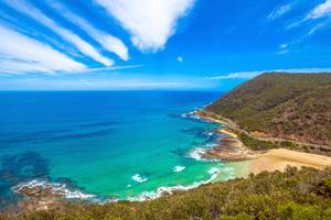
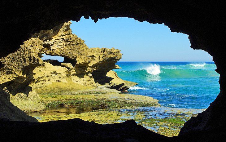
2. Mornington Peninsula National Park
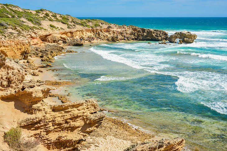
An enticing slice of coastal wilderness on the far western rim of the peninsula, Mornington Peninsula National Park encompasses almost all the wild, windswept ocean beaches. You can explore much of the park's coastal areas on clifftop hiking trails, but be sure to check current conditions before you set out, as parts of the trails are often closed due to erosion.
Other popular things to do in the park include horseback riding on the beach; surfing the ocean swells, particularly at Gunnamatta, Portsea, and Sorrento; picnics; and nature walks.
Perfect for a stroll, Rye Back Beach is a clean, cliff-backed sweep of sand and sea. Walk around the headland here to Lizard Head rock formation, and keep an eye out for the threatened hooded plover along the way. Cape Schanck also has some scenic hiking trails, including one to Pebble Beach, with views of the lighthouse, and another to Eastern Lookout.
For the best chance of spotting wildlife, head to the Greens Bush hiking trails, where you can see a diversity of birdlife, including honeyeaters, parrots, wrens, and even wedge-tailed eagles, as well as kangaroos and wallabies grazing in the grasslands.
Official site: https://parkweb.vic.gov.au/explore/parks/mornington-peninsula-national-park
3. Peninsula Hot Springs
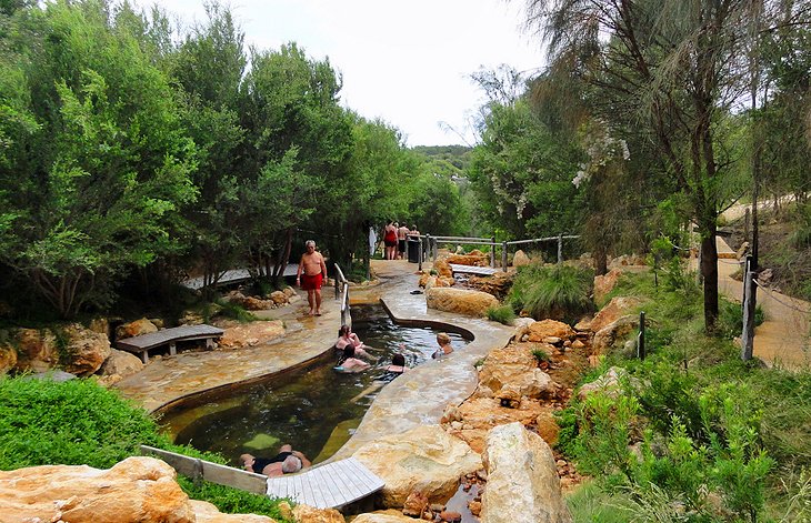
For a totally relaxing travel break, save time to soak in the Peninsula Hot Springs. Hot mineral water oozes from deep underground into the many pools set within a forest of tea trees, and the center is geared for families as well as couples.
With both private and public spaces, each area has been meticulously planned to reflect popular treatments around the world, including a Turkish steam bath, reflexology walk, cave pool, and a hilltop pool with panoramic views.
Bookings are highly recommended, especially in summer and autumn, and you can complement your therapeutic soak with a healthy meal at the café.
Address: Springs Lane, Fingal
Official site: http://www.peninsulahotsprings.com/
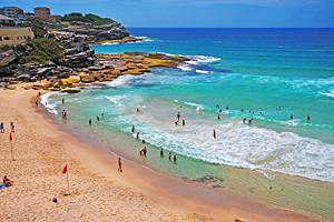
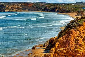
4. Back Beach Walks
Heading to the back beach (ocean-facing beaches) from any area along the Mornington Peninsula is both exciting and soothing. Even on the hottest and crowded days, the wide-open space of sweeping coastline makes for fantastic beach experiences.
Swimming can be dangerous along this stretch of coastline, so any venturing into the water should be on a patrolled part of the beach. This is always indicated by the presence of lifesavers and a system of swimming between the red and yellow flags.
As trails literally zig-zag the entire coast, it's worth picking up a Mornington Peninsula tourist map and walking guide from the visitor center in Sorrento. Popular trails include Sorrento to St. Paul's Beach, Sorrento to Portsea Bay, and Coppins Track from Diamond Bay to Sorrento (or vice-versa).
The All Smiles beach café/restaurant, on the sand at Sorrento Back Beach, is a popular spot to rejuvenate and refresh.
Walking along the back beaches is one of the best free things to do on the Mornington Peninsula, but make sure you check the latest conditions, as parts of the tracks are sometimes closed due to cliff erosion.
5. Point Nepean National Park
At beautiful Point Nepean National Park, you can explore history and nature at the same time. Located at the very end of the Mornington Peninsula, the rugged landscape here was once the center of military activity as a quarantine station and fort, and today, you can visit some of the remnants of the military buildings and forts on hiking trails.
The Fort Nepean Discovery Walk; the Gunner's Cottage Walk, which takes you to the Point Nepean Cemetery, with grave sites dating back to the 1850s; and the Walter Pisterman Heritage Walk are popular hiking trails. You can also rent bikes at the information center if you'd prefer to explore the park on two wheels.
Given the immense size of the park, the hop-on, hop-off shuttle service connecting the major sites is another great way to get around. Self-guided audio tours are available for download at the visitor center near the entrance to the park. This is highly recommended, as the park is full of hidden treasures.
At the very point of the park is where Port Phillip Bay meets Bass Strait. Known as "the Rip," this extremely dangerous stretch of water is where all vessels coming to Melbourne must pass.
Point Nepean National Park is also the location where Australia's 17th Prime Minister, Harold Holt, simply vanished. He was presumed to have drowned, but his body was never found, and a memorial marks the spot where he was last seen.
Official site: http://parkweb.vic.gov.au/explore/parks/point-nepean-national-park
6. Dolphin and Seal Swim
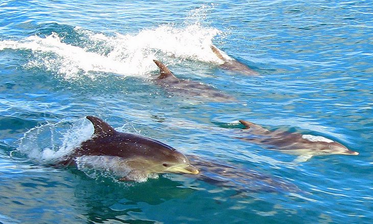
What lies beneath Port Phillip Bay is as alluring as what's on the surface. Home to around 80 wild bottlenose dolphins, the bay offers opportunities for swimming with these playful creatures. It's a highlight of a visit to the Mornington Peninsula.
Pick up a tour from Sorrento onboard either Moonraker or the nostalgic Polperro boat for an adventure of a lifetime. Non-swimmers can spend time relaxing on deck, watching and photographing as the dolphins frolic through the bow wave and swim under the boat.
In addition to the dolphins, it's also possible to swim with the resident Australian fur seal colony and view many species of seabirds.
7. Horseback Riding along the Beach
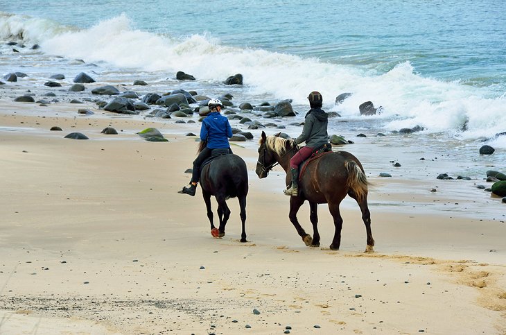
If you're looking for more outdoor activities in the Mornington Peninsula, and you're an animal lover, sign up for a horseback ride along the beach.
Cantering along the sand into the sunset is every horse-lover's dream, and Gunnamatta Trail Rides makes it a reality. Their signature St. Andrew's Beach and Bush Ride takes riders through quiet bush tracks onto the wide, sandy stretch of a surf beach. Available for both experienced and inexperienced riders, this option is offered year-round.
You can also opt for a "Beach and Bathe" package, which includes the St. Andrews Beach ride and a soak in the Peninsula Hot Springs, where you can soothe any sore muscles after your time in the saddle. Lessons, private rides, and special kids' rides are also available.
Address: Trumans Road, Fingal
Official site: http://gunnamatta.com.au/
8. Sorrento to Queenscliff Ferry
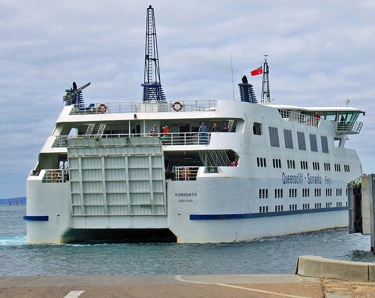
This iconic 40-minute journey takes in the best of Port Phillip Bay. Linking two of Victoria's favorite seaside towns, Sorrento, on the Mornington Peninsula, and Queenscliff, on the Bellarine Peninsula, the ferry service runs on the hour, every hour, every day of the year.
Accommodating vehicles and foot passengers, the ferry has large windows and decks that provide an up-close-and-personal view of the coastline. Dolphins are often spotted from the deck, catching a ride in the bow wave.
You might like to spend a day in Queenscliff and return to Sorrento, or take a one-way journey and continue exploring the state of Victoria from Queenscliff along the legendary Great Ocean Road.
Official site: http://www.searoad.com.au/
9. Arthurs Seat Eagle
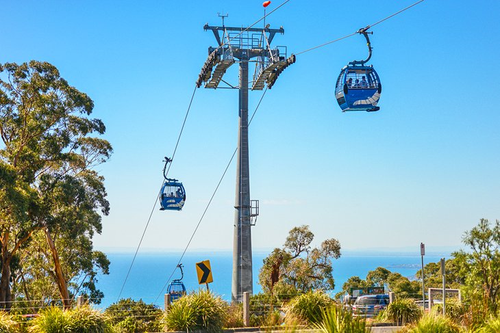
A great way to get a bird's-eye overview of the spectacular Mornington Peninsula is a gondola ride on the Arthurs Seat Eagle. Sweeping panoramas of bushland and the glittering, blue bay, framed by eucalyptus trees, stretch out below you as you glide up to the summit station at the peninsula's highest point.
Once at the top, you can relax with a delicious Devonshire Tea at the café and take one of the short walks to the lookouts for more divine views. The gondola cars protect against all types of weather, so you can enjoy this attraction no matter what the season brings.
Official site: https://aseagle.com.au/
10. Enchanted Adventure Garden
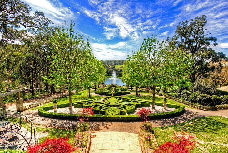
Fun for the whole family, the Enchanted Adventure Garden is the perfect place for wiggly kids to burn off steam. Soar across the park's gardens on ziplines or negotiate your way through the treetops of a century-old eucalyptus forest on the aerial climbing course and canopy walk.
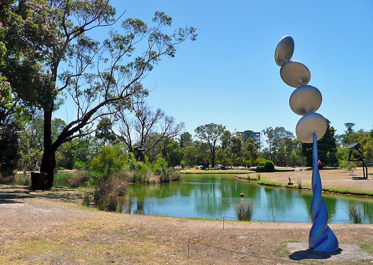
You'll find something to suit all ages here. Kids love scrambling through the hedge mazes, solving giant puzzles, and zooming down the exhilarating tube slide rides. Adults will also love exploring the themed gardens adorned with sculptures.
You can combine a visit here with a gondola ride on the Arthurs Seat Eagle about a five-minute drive away.
Official site: https://www.enchantedmaze.com.au/
11. Ashcombe Maze
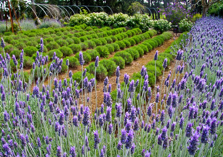
Established in the late 1970s, Ashcombe Maze is the tourist attraction that keeps growing. The original hedge maze is both beautiful and challenging. However, over the years other parts of the property have enhanced the experience with a rose maze that boasts the "oldest circular rose maze in the world" status, a series of lavender gardens, and the Great Gnome Hunt activity.
The café, built from mud bricks, serves a great selection of local produce and is a favorite wedding venue. The drive through the lush hinterland of the Mornington Peninsula surrounding Ashcombe Maze is spectacular, particularly in autumn.
Address: 13-15 Red Hill - Shoreham Road, Shoreham
Official site: http://ashcombemaze.com.au/
12. Red Hill Community Market
As one of the original craft markets of Victoria, the Red Hill market continues to break all records. From its humble beginnings in 1975, the picture-perfect market, held on the first Saturday morning of each month, September through May, houses more than 300 creative stall holders who grow, bake, or make an eclectic array of goodies for the mind, body, and soul.
The country-style bush atmosphere of this hinterland market makes a lovely complement to a beach experience. Go with carry bags and an empty stomach.
Official site: https://www.craftmarkets.com.au/red-hill
13. Art Galleries
With stunning scenery all around, the Mornington Peninsula is home to many artists. A self-guided Peninsula Studio Trail guides visitors through the region, providing an insight into the variety of mediums and styles. Many galleries dot the area, from the magnificent Gordon Studio in Red Hill, where you can see glassblowers in action, to the contemporary Portsea Art Gallery, there is something for every taste. Each January, the Rotary Club of Sorrento holds an important art show that brings artists from all over Victoria together to exhibit their work.
Official site: https://peninsulastudiotrail.org/
Where to Stay in the Mornington Peninsula for Sightseeing
- Luxury Hotels: Perfect for a romantic weekend away or a special celebration, Lindenderry at Red Hill is a 40-room luxury boutique property set amid beautiful gardens. Delicious farm-to-table fare and wonderful staff enhance a stay here. Foodies will also love the stylish Jackalope Hotel, with tasting menus in the hatted restaurant. Sleek styling, smoky hues, and an enticing infinity pool are other highlights. At the contemporary RACV Cape Schanck Resort floor-to-ceiling windows reveal spectacular views of the rolling green landscapes, with ocean glimpses from the farthest rooms. The top-notch gym, day spa, sauna, games room, golf course, multiple restaurants, and indoor pool add to the impressive amenities, and you can choose from many different room types.
- Mid-Range Hotels: In the charming coastal village of Flinders, the four-star boutique Flinders Hotel offers light-filled contemporary rooms, with high-end linens and bath accessories. Gourmands can dine in one of the popular on-site eateries and sign up for cooking lessons at the Georgie Bass Café & Cookery. Breakfast is included in the rates. If you fancy a round or two of golf with your Mornington Peninsula sightseeing, Peppers Moonah Links Resort is for you. Rooms and suites feature balconies with views over the two golf courses, and you can relax at the day spa, swim in the solar-heated pool, horseback ride, mountain bike, and soak in the Peninsula Hot Springs next door. For historical charm, Brooklands of Mornington is a great-value choice set in lovely gardens, with spacious rooms and comfy beds. A French bistro is on-site, and you can swim in the indoor pool.
- Budget Hotels: Sparkling clean rooms and a short hop to its namesake beach are the highlights of the Bay Motel Safety Beach, and you can walk to nearby restaurants. Also offering modern motel-style accommodation, the family-owned and operated Sorrento Beach Motel is a short walk from the town center, while the Frankston Motel is clean and convenient with an outdoor pool, tennis court, and barbecue facilities.
Map of Tourist Attractions on the Mornington Peninsula
More Related Articles at PlanetWare.com
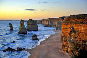
More Melbourne Getaways: The Mornington Peninsula is one of many popular weekend getaways from Melbourne. You can visit the spectacular scenery along the Great Ocean Road on a day trip from Melbourne, and the Yarra Valley and Dandenong Ranges is another top weekend escape, with beautiful wilderness areas, abundant wildlife, and wonderful food.
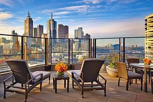
City Sights: Multicultural Melbourne is the perfect spot for a city fix. Galleries, gardens, museums, shops, and a dizzying array of restaurants are some of the top attractions in this sports-mad city.