20 Top-Rated Tourist Attractions in Turkey
Author Jess Lee lives in Turkey and has been writing about traveling in Turkey for over a decade. She has authored several travel guidebooks to the country.
Packed to the brim with ancient monuments left over from a parade of empires, and endowed with showcase scenery that never fails to impress, Turkey is a dazzling destination that straddles Asia and Europe.
Its vibrant culture, famous food, and vast history wow all who venture here, while its glorious landscapes, from the sun-soaked Mediterranean to the mighty mountains and arid steppe, are tourist attractions in themselves.
Whether you want to lap up the Byzantine and Ottoman glories of Istanbul on a city break, laze on the beach, delve into history wandering through ruins such as Ephesus, or see some of the world's most surreal panoramas in Pamukkale and Cappadocia, this country offers visitors a wide range of things to do.
For ideas on the best places to visit read our list of the top tourist attractions in Turkey.
- 1. Hagia Sophia (Aya Sofya) Mosque
- 2. Ephesus
- 3. Cappadocia
- 4. Topkapı Palace
- 5. Pamukkale
- 6. Antalya
- 7. Cruising the Mediterranean
- 8. Mount Nemrut
- 9. Ölüdeniz
- 10. Aspendos
- 11. Patara
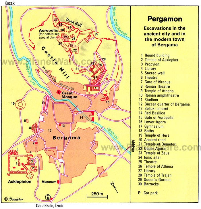
- 12. Pergamum
- 13. The Blue Mosque
- 14. Troy
- 15. Ani
- 16. Safranbolu
- 17. The Bosphorus
- 18. Gaziantep Zeugma Mosaic Museum
- 19. Göbeklitepe
- 20. Sumela Monastery
- Best Time to Visit Turkey
1. Hagia Sophia (Aya Sofya) Mosque
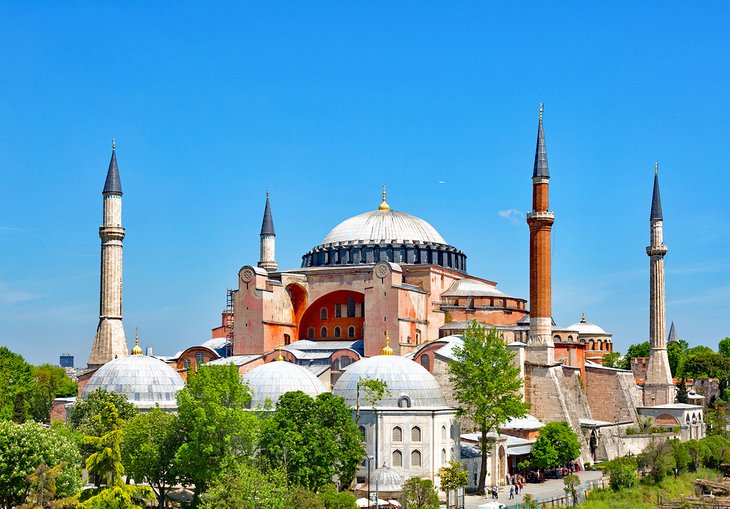
Highlight: Take in the majestic interior of one of Istanbul's most iconic buildings
Renowned as one of the most beautiful buildings in the world, the spellbinding Byzantine glory of the Hagia Sophia Mosque (Aya Sofya) is not only one of the top things to do in Istanbul, but also in Turkey.
Built by the Byzantine Emperor Justinian in 537 CE, it is renowned as the Byzantine Empire's greatest architectural achievement and has remained the world's largest church for 1,000 years.
The staggering bulk of its exterior is rimmed by the delicate minarets added after the Ottoman conquest, while the sumptuous and cavernous frescoed interior is a grand reminder of old Constantinople's might and power.
This famed monument is a must-do for every tourist visiting the country.
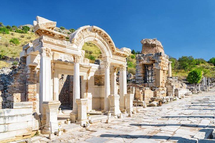
2. Ephesus
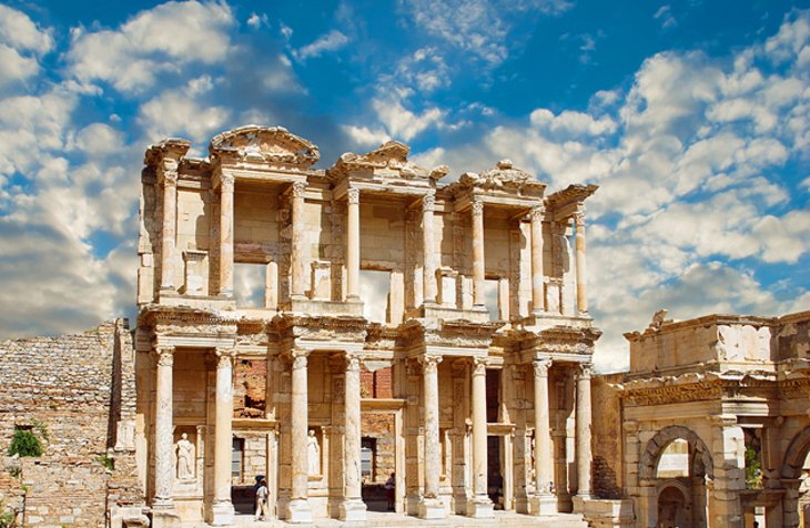
Highlights: Crane your neck at the Library of Celsus, hike up the cavea of the Great Theater, and stroll amid the ruins of this ancient city
Not to be missed, the mighty ruin of Ephesus is a city of colossal monuments and marble-columned roads.
One of the most complete, still-standing famed cities of antiquity in the Mediterranean region, this is the place to experience what life must have been like during the golden age of the Roman Empire.
The city's history dates back to the 10th century BCE, but the major monuments you see today all date from its Roman era when it was a thriving commercial center.
In particular, the Library of Celsus, the complex of frescoed terraced houses, and the Great Theater all point to the wealth and importance of Ephesus during the Roman period.
A sightseeing trip here will take at least half a day to cover the major highlights and longer, if you really want to explore, so make sure you plan your visit so you don't feel rushed.
- Read More: Visiting Ephesus: Attractions, Tips & Tours
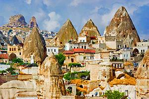
3. Cappadocia

Highlights: Take in panoramic views from a hot-air balloon, hike within valleys of volcanic rock, and marvel at cave-chapel Byzantine art
The surreal, swooping rock valleys of Cappadocia are every photographer's dream.
Cliff ridges and hill crests are home to rippling panoramas of wave-like rock or wacky-shaped pinnacles that have been formed by millennia of wind and water action.
And if you don't feel like hiking for the views, this is one of the world's top destinations to take a hot-air balloon ride.
Nestled in this unique lunar-like landscape are the frescoed rock-cut churches and cave-cut architecture of the Byzantine Era, when this area was home to monastic Christian communities.
In particular, the multiple cave-churches of Göreme Open-Air Museum and Ihlara Valley are home to some of the best examples of surviving mid-Byzantine-era religious art in the world.
Cappadocia's villages, half hewn into the hillsides, where travelers base themselves to explore the surrounding countryside, are also an attraction in themselves, with their boutique hotels that allow you to bed down in a cave with full contemporary comforts.
Read More:
4. Topkapı Palace
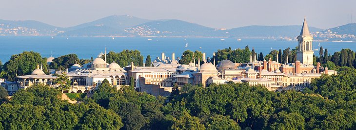
Highlights: Soak up the Ottoman finery amid the salons of the sultans
Sumptuous beyond belief, Istanbul's Topkapı Palace takes you into the fantastical, opulent world of the Sultans.
It was from here, during the 15th and 16th centuries, that the sultans of the Ottoman era carved out an empire that would extend up into Europe and down through the Middle East and into Africa.
The interiors, with their decadently exuberant tiling and lavish jeweled decor, are an unforgettable peek into the Ottoman's power base.
In particular, don't miss the Imperial Council building, where the empire's business was conducted by the Grand Vizier; the arms collection displayed in the Imperial Treasury; the world-class collection of miniature paintings; and the dazzling Harem rooms, which were designed by the famed Ottoman architect Sinan.
The surrounding public gardens were once the sole domain of the Royal Court but are now open to the public and provide a tranquil, green respite from the city streets.
- Read More: Top-Rated Tourist Attractions in Istanbul
5. Pamukkale

Highlights: Hike up the famed white terraces, swim in the antique pool, then take in the views from the top tier of the theater's cavea
One of Turkey's most famous natural wonders, the pure white travertine terraces of Pamukkale ("Cotton Castle" in English) cascade down the slope looking like an out-of-place snowfield amid the green landscape.
Although the travertines are themselves a highlight of a Turkey trip, the vast and rambling ruins of Greco-Roman Hierapolis, an ancient spa town, lie scattered across the summit of this calcite hill.
After exploring the ancient theater, with its views across the countryside, and the remnants of the city's agora, gymnasium, necropolis, and grand gates, you can swim in the mineral-rich waters which made this ancient spa town famous, in the antique pool.
Afterward, walk down the travertine hill, wading through the pools of water in the upper terraces, to the small modern village of Pamukkale below.
For the best photographs, come at dusk when the travertines glow as the sun sinks below the horizon.
- Read More: Top-Rated Tourist Attractions in Pamukkale
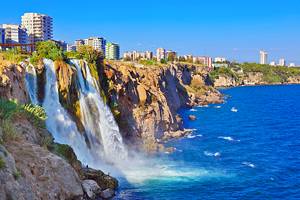
6. Antalya
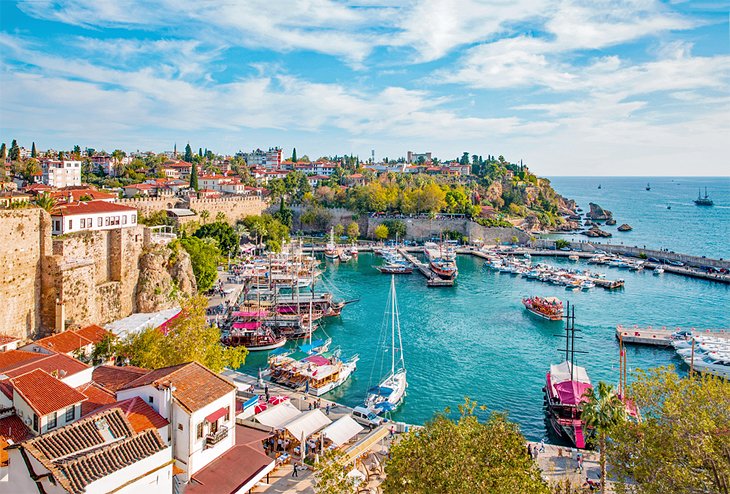
Highlights: Stroll the twisty lanes of the old town, sloth on the beach, or launch yourself out on history-filled trips amid the hilltop ruins of the hinterland
This bustling Mediterranean hub has something for everyone.
The two main beaches outside of town are sun-sloth heaven in summer and attract holidaymakers from across Europe. While the old town area, snug right in the center of town, with its cobblestone alleyways rimmed by creaky Ottoman-era mansions, is a wonderful place to explore.
The Antalya Museum is renowned as one of the country's best, with an astonishing collection of Hellenistic and Roman marble statuary, and there are bags of attractions outside of town for travelers who want to use Antalya as a base.
In particular, Antalya is an easy base for day trips to some of Turkey's most famous Greco-Roman ruins, including Aspendos and Perge, which are just outside the city, and the town of Side, with its glut of ruins.
- Read More: Top-Rated Tourist Attractions in Antalya
7. Cruising the Mediterranean
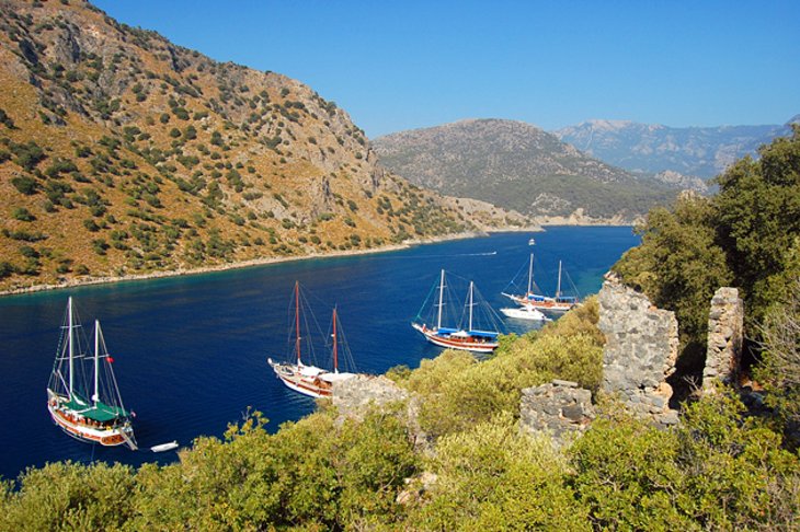
Highlight: Experience Turkey's dramatic coastline from the sea on a scenic slow-travel adventure
Turkey's Mediterranean coastline has ruins galore and many things to do, but for many people, it's all about soaking up the sun while enjoying the gorgeous coastal views.
Cruising on a yacht is the number one activity for visitors to Bodrum and Fethiye for good reason. The steep forest-clad slopes, hidden coves sporting tiny white-sand beaches, and hundreds of scattered islands are the perfect place for exploring by sea. Even diehard landlubbers will be impressed.
One of the most famous trips is known as the Blue Cruise and travels from Fethiye south down the coast until disembarking near Olympos, home to the famous natural phenomenon of the Chimaera.
- Read More: Top-Rated Tourist Attractions in Bodrum
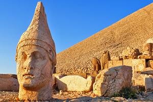
8. Mount Nemrut
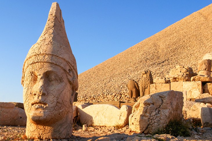
Highlight: Hike up to the summit to see the sun rise over the mountaintop ruins
The top sightseeing drawcard for eastern Turkey, Mount Nemrut's summit funerary mound is scattered with the broken remnants of once mammoth statues, which guarded it.
This weird and lonely place has to be one of Turkey's most peculiar archaeological sites. The giant stone heads of long-forgotten gods stare out from the summit, casting an eerie atmosphere over the barren mountaintop.
The summit's building works are the work of Antiochus I, ruler of the Commagene Kingdom, which lay here in the buffer region between the Roman and Parthian empires.
Antiochus I dedicated this grand funerary mound to himself as a showcase of his importance, raising a 50-meter-high artificial peak on Mount Nemrut's summit and then decorating it with statues of himself and various gods.
The most popular time to visit is at sunrise, so you can watch the statues as they loom out of the dark.
- Read More: Exploring Mount Nemrut: A Visitor's Guide
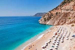
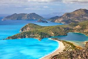
9. Ölüdeniz
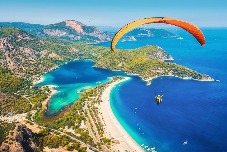
Highlights: Turkey's tandem paragliding hub, resort living, and lazy beach life
Impossibly turquoise-blue water. Check. Lush green forest tumbling down a cliff to a white-sand beach. Check. The sheltered inlet of Ölüdeniz, just a short journey from Fethiye, is Turkey's most famous beach, and with scenery that might as well have fallen off a perfect postcard, it's easy to see why its popularity hasn't waned.
If the beach gets too crowded, it's time to take to the skies and experience the stunning aerial views on a tandem paragliding dive off the summit of mighty Babadağ (Mount Baba), which rises up behind the shore.
Oh, did we mention that Ölüdeniz is one of the world's top paragliding destinations? Check.
- Read More: Top-Rated Tourist Attractions in Fethiye
10. Aspendos
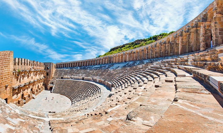
Highlight: Admire this monumental relic of Roman rule
Just south of the resort city of Antalya, the jaw-dropping mammoth bulk of the Roman Theater of Aspendos celebrates the pomp and ceremony of Marcus Aurelius' rule.
Considered the finest surviving example of a classical age theater still standing in the world, the highly restored, 15,000-seat theater is one of antiquity's star attractions.
Although the theater is the main reason for a visit here (and for most visitors on a half-day trip from nearby Antalya or Side, the theater is all they see) the Aspendos site offers plenty more ruins to explore.
There are remnants of an aqueduct, agora, stadium, and a Byzantine-era basilica, all scattered over the vast hillside area here surrounding the theater.
Read More: Aspendos: A Visitor's Guide
11. Patara
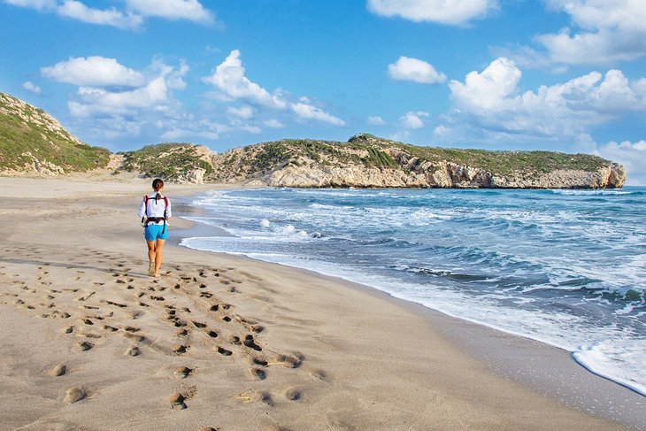
Highlights: Hike amid the Lycian ruins then relax on Turkey's longest beach
With such a long Mediterranean coastline, there's a beach for every type of sun worshipper in Turkey, but Patara is among its most famous swathes of sand.
Trailing for 18 kilometers along the shoreline, the beach offers plenty of space, so even in the height of summer, you can still find a quiet spot far away from the crowds.
Adding to the experience, just behind the sand, are the vast ruins of Ancient Patara, which include a colonnaded street, restored bouleuterion (the parliament of the city), and a theater that sat 5,000 people.
Once you've had your fill of sun, sand, and swimming, wander behind the sand dunes and explore the crumbling remnants of this once-prosperous Lycian city.
Patara is easily reached from both Kas and Fethiye.
- Read More: Top-Rated Attractions in Fethiye
12. Pergamum
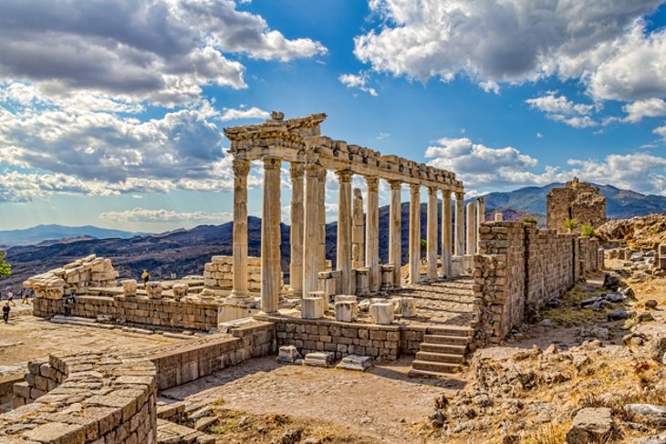
Highlights: Panoramic vistas across the ruins and surrounding hills from the Acropolis and theater
Turkey has an abundance of Greco-Roman ruins, but none can be so romantically placed as ancient Pergamum in modern-day Bergama.
Once home to one of the ancient world's most important libraries (which rivaled Alexandria's library in prominence) and home to the famed medical school run by Galen, Pergamum's remaining temple remnants now preside dramatically across a hilltop.
It's an incredibly atmospheric place to explore. The Acropolis area with its theater cut into the hillside holds the most remains and offers sweeping panoramic views across the countryside.
Below, the Asklepion area is home to the ruins of the city's renowned medical center.
This is a great place to visit if you want to get a real feel for life in the Classical era.
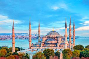
13. The Blue Mosque
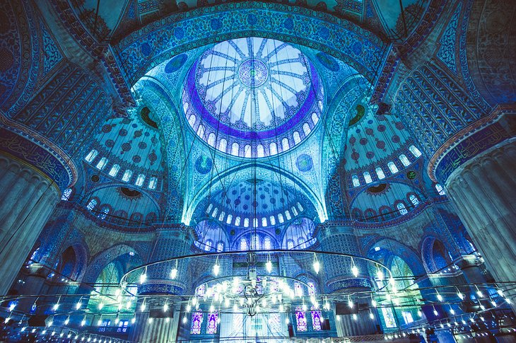
Highlight: An opulent interior with the Ottoman era's delicately detailed blue-and-white tiles
This famous mosque (officially called the Sultanahmet Mosque), facing the Hagia Sophia Mosque across Sultanahmet Park in Istanbul, is one of Turkey's most visited monuments.
Built by Sultan Ahmed I, the mosque was designed to mimic the Hagia Sophia by the architect Sedefkar Mehmet Ağa, a disciple of the Ottoman era's most renowned architect, Sinan.
With six slender minarets and a sprawling courtyard complex, everything about the Blue Mosque is on a grand scale but it's best known for its prayer hall interior covered in tens of thousands of blue Iznik tiles (for which the mosque gained its moniker), lit by shards of light from 260 windows.
Non-worshipping visitors are welcome to visit outside of prayer times. Everyone must have knees and shoulders covered, and females must wear a headscarf.
14. Troy
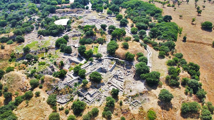
Highlight: Strolling amid the ruins of one of the Classical world's most famous mythical cities
One of Turkey's most well-known ancient ruins, this site is thought by many to be the Troy of Homer's Iliad.
Whether it is, or not, the Troy of the Trojan War myths, the multi-layered, rambling ruins here expose a vast history of occupation, abandonment, and reoccupation that stretches right back to the early Bronze Age.
The ruins include well-preserved city walls and fortifications, the remnants of a palace, megarons (Mycenean hall complexes) and houses, along with later Roman-era sanctuary and Odeon monuments.
Just down the road from the Troy site is the new Troy Museum, one of Turkey's best museums.
The vast and thoughtfully collated collection inside tells the tale of Troy, from its earliest occupation right through to the modern era, including the mythology that surrounds the site; the controversial and damaging excavations of early archaeological work here; and the story of the missing cache of gold, silver, and copper artifacts (known as Prium's Treasure) currently held at Moscow's Pushkin Museum, which were unearthed at the site and illegally smuggled out of Turkey by Heinrich Schliemann.
Read More: Visiting Troy from Istanbul
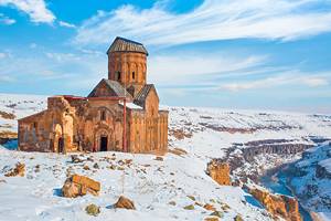
15. Ani
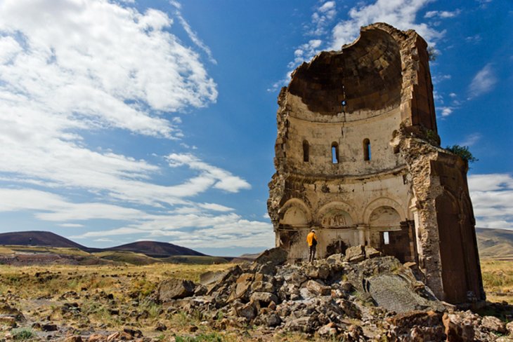
Highlight: Rambling this vast site of shattered churches set high on the steppe
The ruins of the powerful Silk Road city of Ani sit abandoned on the plains rubbing up against Turkey's modern border with Armenia.
Once capital of the Armenian Kingdom, Ani's golden age came to an end in the 14th century after Mongol raids, earthquake destruction, and trade route tussling all played their part in the city's decline.
The beautiful red-brick buildings still crumbling away amid the steppe grass have a mesmerizing effect on all who visit.
Don't miss the Church of the Redeemer and the Church of Saint Gregory, with their elaborate stone masonry and fresco remnants still visible; the bulky Ani Cathedral building; and the Manuçehr Mosque, built by the Seljuk Turks when they captured the city in the 11th century and thought to be the first mosque built in what would become Turkey.

16. Safranbolu
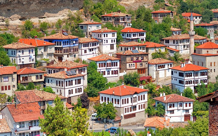
Highlight: Idly wandering cobblestone streets amid the old town of wood-beamed mansions
Turkey's best-preserved Ottoman town is a fabulously photogenic place of skinny winding alleys crammed with finely restored wooden mansions which were once the home of wealthy merchants and now have been transformed into boutique hotels and restaurants.
There's little to actually do in town. Instead, this is a place to simply stroll the streets and admire the old-world atmosphere.
It's also known for its traditional sweets and crafts and there are plenty of cute shops where you can pick up a unique souvenir.
If you're road-tripping inland from Istanbul, this is a fantastic place to stop-off for the night and experience the historic ambience.
- Read More: Top-Rated Tourist Attractions in Safranbolu
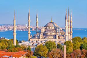
17. The Bosphorus
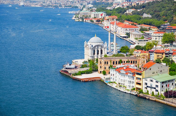
Highlight: Take a scenic sightseeing trip on Istanbul's famed continent-dividing strait
One of the world's great waterways, the Bosphorus Strait separates Europe from Asia and connects the Black Sea with the Sea of Marmara (and hence, out to the Mediterranean).
Cruising along the Bosphorus, whether by hopping local ferries, on a tourist ferry cruise, or a private boat, is one of the great tourist attractions of an Istanbul stay. This is the most relaxing sightseeing opportunity in Istanbul.
Onboard, it's all about soaking up the scenery from the water, with the shorefront lined with Ottoman palaces; villas; and wooden mansions out to Rumeli Fortress, built by Mehmet the Conqueror; and (farther north along the strait), the Byzantine-era ramparts of Anadolu Fortress.
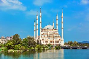
18. Gaziantep Zeugma Mosaic Museum
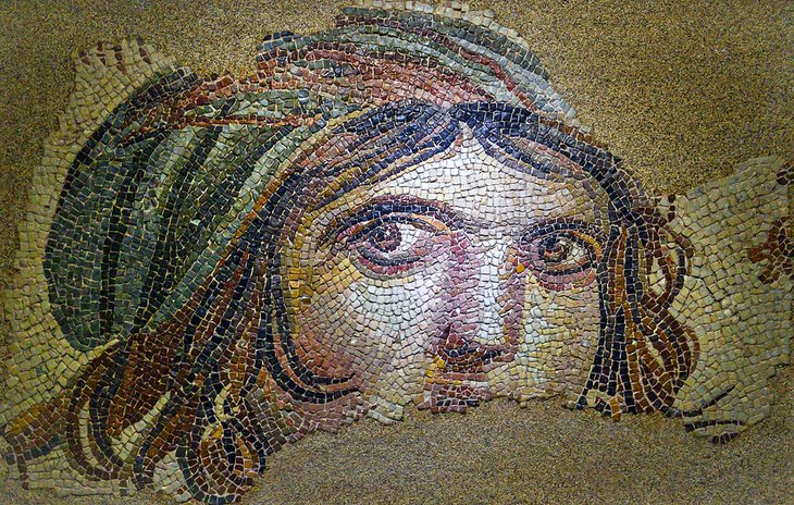
Highlight: A dazzling collection of Greco-Roman mosaic artistry
Due to the ongoing aid response in the aftermath of Turkey's February 2023 earthquake, the Gaziantep Zeugma Mosaic Museum has been temporarily closed. For information on reopening, check the official museum website.
The city of Gaziantep is one of southeastern Turkey's great highlights for a few days of guzzling Gaziantep's renowned baklava and strolling the alleys of its old city district, but its most famous attraction is the Gaziantep Zeugma Mosaic Museum.
The museum contains both one of the largest and most important mosaic collections in the world.
Nearly all the Hellenistic and Roman-era floor mosaics displayed here are originally from the Greco-Roman ruins of the town of Zeugma, which is now half-submerged due to the construction of the Bericik Dam. The mosaics, cleverly curated and displayed so that they can be viewed from their best angles, provide visitors with a sense of the artistry of the Greco-Roman era.
Despite the many huge mosaics here, the most famous mosaic in the collection, known as the Gypsy Girl, is one of the smallest pieces. It is displayed dramatically in its own darkened room, so that the intricate artistry of the piece can be better appreciated.
Read More: Top-Rated Attractions & Things to Do in Gaziantep
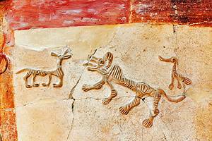
19. Göbeklitepe
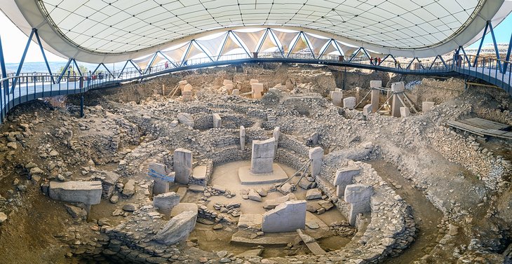
Highlight: Soaking up the atmosphere of standing amid the world's earliest religious monument
One of Turkey's most important ancient ruins, the hilltop site of Göbeklitepe, near Şanlıurfa, has generated hundreds of headlines worldwide, been anointed with UNESCO World Heritage status, (and provided the inspiration for the Netflix series The Gift) since it was opened to the public.
This small site of towering T-shaped pillars, inscribed with animal figures and anthropomorphic details, dates from the pre-pottery Neolithic era and is thought by archaeologists to be the world's earliest religious sanctuary.
Although it may not have the wow-factor of Turkey's many, much later Bronze Age and Greco-Roman ancient sites, Göbeklitepe's importance in our understanding of early human history has made it one of the most popular tourist attractions in Turkey's southeast.
Read More: Top-Rated Attractions & Things to Do in Şanlıurfa
20. Sumela Monastery
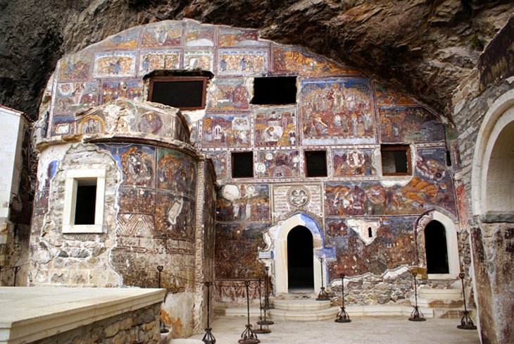
Highlight: Exploring this stunning Byzantine religious center that clings to the cliff-side
With its stunning, lonely setting, built into a cliff face, Sumela Monastery (Monastery of the Virgin Mary) is the star attraction for visitors along the Black Sea Coast.
Wandering around this abandoned religious complex, with its church interiors crammed with dazzling and vibrant frescoes, is a must for anyone who makes the long journey to Turkey's northeast region.
The monastery first opened during the Byzantine era and only ceased operation as a working religious center in 1923, when the monks were forced to leave as part of the Greek-Turkish Population Exchange.
Today, wandering its empty cells, it's easy to imagine the isolated lives of the monks who once lived here.
Best Time to Visit Turkey
Overall, depending on what you plan to do, Turkey can be visited year-round, but for the most dependable weather, the best times to visit are the months of May, June, July, August, September, and October.
May, June, September, and October are the prime time for Turkey travels, with plenty of blue skies and sunshine and softer light for photography, but fewer crowds. Just remember to pack a warmer layer for after dark and a jacket in case of rain.
Spring wildflowers bloom across the countryside in May, while the displays of colorful fall foliage during October make these two months the best for keen photographers.
July and August are the most popular months to visit, with temperatures regularly peaking over 30 degrees Celsius and little chance of rain disrupting your plans. If you're here specifically for the beach and activities on the water, this is peak season.