Tourist Attractions in Australia's Northern Territory
A land of stark beauty, sacred Aboriginal sites, and sweeping wilderness, the Northern Territory has always stood apart from the rest of Australia. Vast deserts, wetlands, monsoonal rains, red-rock gorges, and raging rivers spark the spirit of adventure in those who visit, and wilderness adventures top the list of things to do.
"The Territory" is also rich in culture. The Traditional Owners of this land managed to preserve their way of life for much longer than other areas of the country, and today you can learn about how they thrived here for thousands of years.
The Red Centre, in the south of The Territory, is a land of parched deserts and striking rock formations. Uluru, the iconic red monolith, is one of the region's most famous tourist attractions. Northwest of here lies the legendary outback town of Alice Springs, a popular base for wilderness safaris.
The tropical Top End, or northern part of the state, encompasses the World Heritage-listed Kakadu National Park, famed for its Crocodile Dundee scenes; beautiful Litchfield National Park; Nitmiluk National Park; and the First Peoples settlements of Arnhem Land. Also in the Top End is multicultural Darwin, the capital of the Northern Territory.
Find the best places to visit in this rugged outback region with our list of the top tourist attractions in the Northern Territory, Australia.
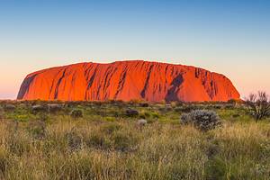
Uluru-Kata Tjuta National Park
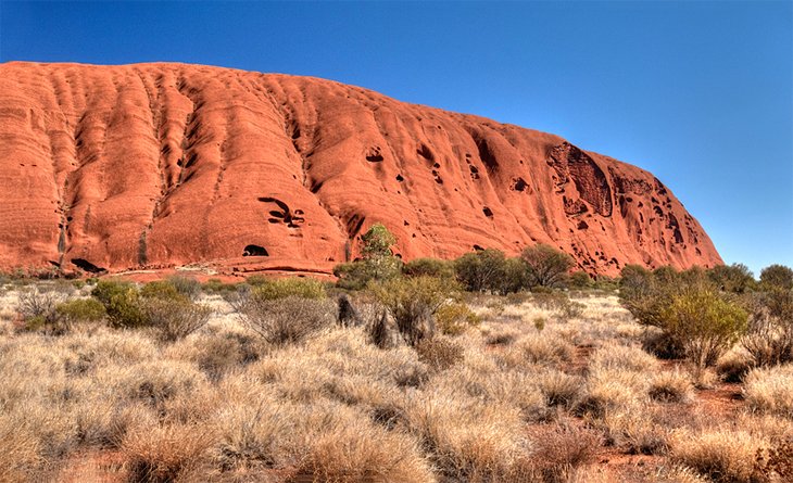
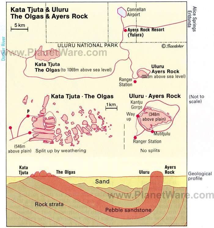
In the Red Centre, World Heritage-listed Uluru National Park, is one of Australia's most famous tourist attractions. The park's main features include Uluru (formerly Ayers Rock), the 348-meter-high red monolith rising from the desert, and the dome-shaped rocks called Kata Tjuta (the Olgas), which lie 40 kilometers away from Uluru. Oxidation or rusting of iron in the rock gives the structures their beautiful red coloring.
Both sites hold deep spiritual significance to the Traditional Owners, the Anangu people, who manage the park jointly with Parks Australia. Around dusk, visitors gather at sunset viewing areas to photograph these impressive structures, when the play of color is at its finest. To really appreciate these sacred sites join a sightseeing tour led by an Indigenous guide.
Official site: http://parksaustralia.gov.au/uluru/
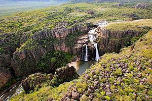
Kakadu National Park
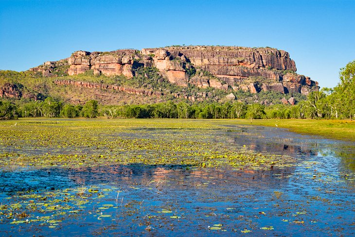
Kakadu's wild beauty will haunt your memory for a lifetime. Awarded dual World Heritage Status both for its outstanding natural and cultural value, this spectacular Top End wilderness area is Australia's largest national park and one of the top places to visit on a Northern Territory travel itinerary.
Landscapes range from lush wetlands to arid upland country. On the north coast lies the tidal zone, with river estuaries, mangrove swamps, and tall monsoon rainforests. Inland are the flood plains, where rivers pursue a winding course to the sea. Boat tours, like the Yellow Waters cruise and the Guluyambi Cultural Cruise take you through some of these waterways to view the unique plants and animals, including crocodiles and an impressive diversity of birds.
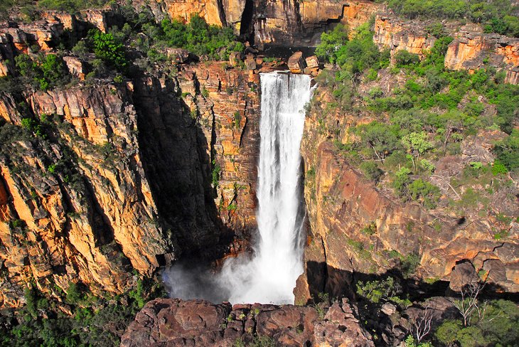
Waterfalls are among the many highlights of Kakadu. The escarpment of the Arnhem Land plateau runs diagonally through the park, from southwest to northeast. After heavy rain, water pours over its bare rocks and down the escarpment in magnificent tiers of thundering falls – Jim Jim Falls and Twin Falls are two of the most famous.
Hiking trails and the main access roads radiate through the gently rolling upland country, and this is the best way to explore the top attractions in this part of the park.
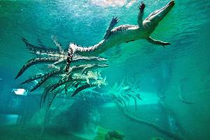
Wildlife mirrors the incredible diversity of habitats. Among the animals you can spot here are more than 70 different species of reptiles, the largest and most dangerous of which is the saltwater crocodile, as well as a vast array of fish, mammals, and birds.
In addition to all these natural attractions, the park is home to many sacred Aboriginal sites, and rock paintings dating back more than 20,000 years. Ubirr and Nourlangie hold Australia's most important collection of Aboriginal art.
You can visit Kakadu from Darwin, but this vast wilderness area deserves more than just a day trip. If you want to stay longer, consider basing yourself at Jabiru.
Note that seasonal flooding may close some sections of the park, especially during the wet season. For comprehensive information on the natural history and culture of this unique area stop by the National Park's Visitors Centre in Jabiru.
Official site: http://www.parksaustralia.gov.au/kakadu/index.html
Mindil Beach & Mindil Beach Markets, Darwin
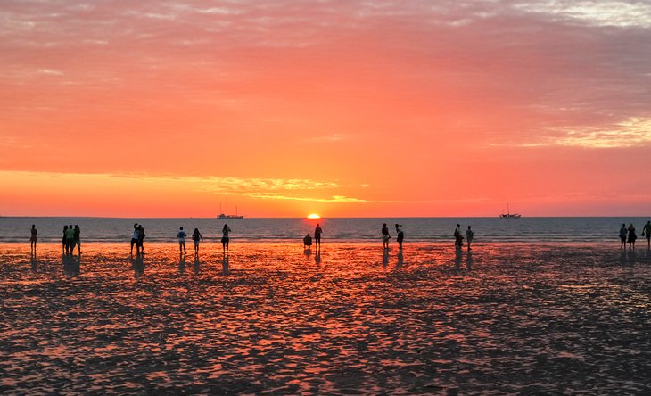
Multicultural Darwin is the youngest of the Australian state capitals and the gateway to wilderness adventures like Kakadu and Litchfield National Parks. But you'll find plenty of rewarding things to do in Darwin before you head out. Watching the sunset at Mindil Beach should be top on your list.
A mere five minutes from Darwin's city center, this rather unassuming stretch of sand and sea is the setting for a curious ritual. Every evening at sunset, throngs of tourists and locals plonk down on the shore to watch the sun dip into the tranquil Timor Sea. It's one of the best free things to do in the Northern Territory.
Mindil Beach also hosts the tourist-favorite Mindil Beach Sunset Markets. Come here every Thursday and Sunday evening to feast on tasty treats from around the world, buy souvenirs for your friends back home, or just soak up the scene of happy tourists. Live music adds an upbeat soundtrack, and the general vibe is one of a huge communal picnic catered by the many food stalls.
From Mindil Beach, wander along scenic waterfront paths to East Point Nature Reserve, where you can learn about Darwin's fascinating history at the Darwin Military Museum.
Nitmiluk National Park
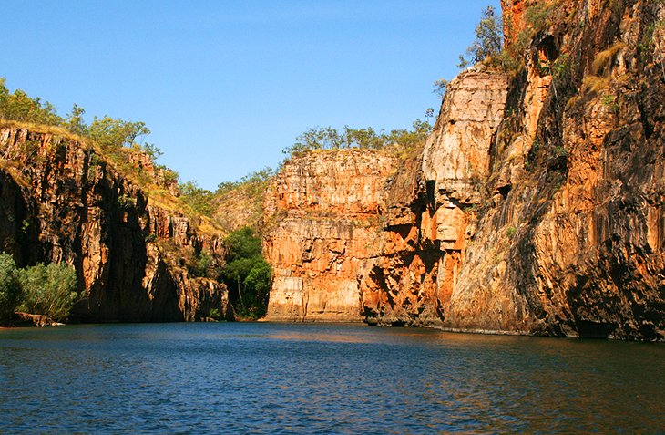
Formerly known as Katherine Gorge, Nitmiluk National Park is one of the most famous Top End tourist attractions. The main must-see site is the series of gorges. Up to 100 meters deep, they were carved by the Katherine River through the soft sandstone of the southern Arnhem Land plateau.
During the dry months, the river carries little water, leaving a series of pools separated by rocks and boulders. During the wet season, the river is at its most impressive as it surges tumultuously through the narrow gorges.
In contrast to the arid Arnhem Land plateau, the perennial flow of the Katherine River nourishes luxuriant vegetation and diverse wildlife, including freshwater crocodiles and more than 160 species of birds.
Boat trips through the gorges are one of the most popular ways to explore Nitmiluk National Park. But you can also explore the park on foot. Trails range from a two-hour hike to the viewpoint above the first gorge to a five-day hike to Leliyn (Edith Falls) in the park's northwest.
Kayak rentals and helicopter flights are other popular ways to experience the park.
Official site: https://nt.gov.au/parks/find-a-park/nitmiluk-national-park
Darwin's Waterfront & Stokes Hill Wharf

Darwin's Waterfront Precinct is the best place to soak up the city's salt-tinged setting. Stroll along the waterfront promenade here, in the heart of the city, and see what piques your interest. You'll find everything from tourist attractions and art galleries to restaurants, parks, shops, and, of course, glistening water views.
Traveling with kids? Stop by the Darwin wave lagoon or water park for a cool dip, pop by the waterfront park for a clamber on the rock climbing wall, or relax with a picnic on the white-sand beach. History buffs will enjoy a visit to the World War II secret Oil Storage Tunnels. At night, take the family to the Deckchair Cinema to catch the latest flicks.
Just a few minutes' stroll across the bridge from Darwin Waterfront is Stokes Hill Wharf. Another tourist favorite, this working wharf is the departure point for harbor cruises, Jet Ski tours, and fishing charters. It's also a great place to visit for an alfresco seafood meal.
Prefer to catch your own fish? Cast a line from the free fishing platforms here. Stokes Hill Wharf is also home to the Royal Flying Doctor Service (RFDS) Darwin Tourist Facility, one of Darwin's top museums.
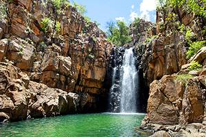
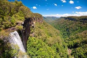
Litchfield National Park
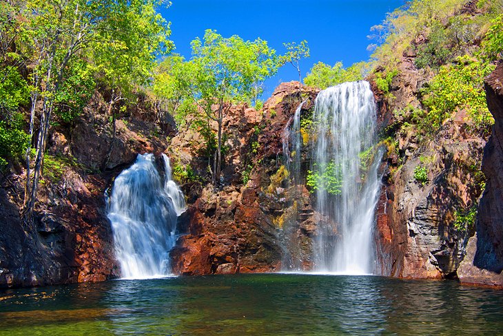
About a 90-minute drive from Darwin, beautiful Litchfield National Park is a popular day trip from the capital. It's great way to experience the Top End wilderness without traveling all the way to Kakadu.
Among Litchfield's main attractions are its beautiful waterfalls and freshwater springs, which flow from the escarpment of the Tabletop Range and tumble over steep cliffs.
The park scenery is also beautiful. It varies from patches of tropical monsoon forest around the waterfalls and ponds to open woodland and giant magnetic termite mounds. Don't miss the Lost City. This formation of large sandstone columns sits near Tolmer Falls in the park's west.
Bushwalking and hiking are particularly rewarding. You can also enjoy a dip in the park's plunge pools and swimming holes; explore the ruins of the Blythe Homestead; and visit Wangi Falls, one of the most popular swimming and picnicking spots.
Sealed roads lead to most of the major attractions, but 4WD vehicles are recommended to access some of the park's more remote features.
Official site: https://nt.gov.au/parks/find-a-park/litchfield-national-park
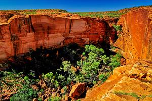
Kings Canyon (Watarrka National Park)
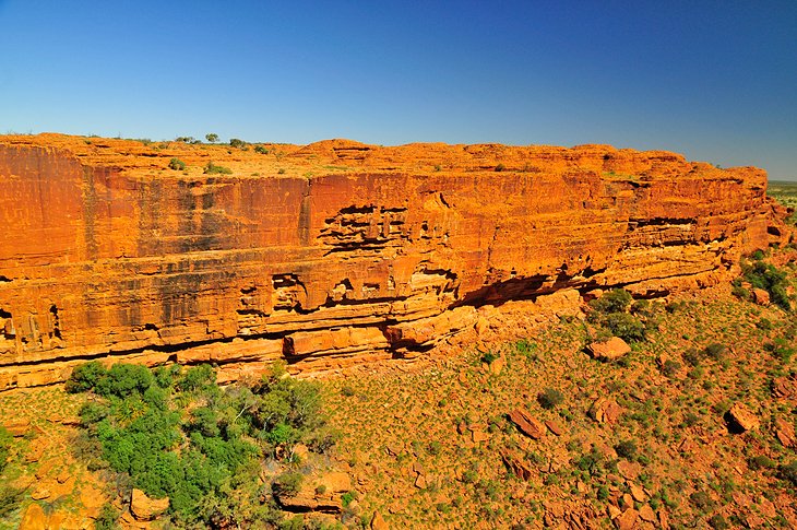
Part of Watarrka National Park and located about midway between Alice Springs and Uluru, Kings Canyon has the deepest gorge in the Red Centre. The scenery is spectacular. Orange-red rocks glow against a typically deep blue sky, and the sandstone walls of the canyon rise to heights of 100 meters, almost looking like they were cut with a knife.
The park is also surprisingly lush in areas. On the bottom of the canyon are perennial waterholes, and ferns and palm forests line the upper part of the gorge – especially in the area called the Garden of Eden. More than 600 species of native plants and animals live in the region.
To the Luritja people, this area was sacred, and their dwellings and places of assembly are decorated with rock paintings.
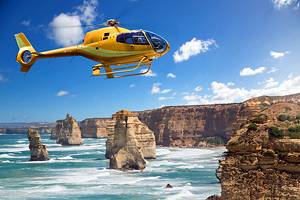
One of the best ways to explore Watarrka National Park is on the network of scenic hiking trails. The steep six-kilometer Kings Canyon Rim Walk is one of the top hikes in Australia. Scenic flights and camel safaris are other ways to explore the park.
Official site: https://nt.gov.au/parks/find-a-park/watarrka-national-park
Darwin's Museums & Galleries
Despite its laid-back feel, Darwin has a turbulent history, and you can learn all about it at the city's excellent museums.
Darwin's World War II history shaped the country. This seemingly sleepy tropical city was the site of Australia's largest single attack by a foreign power, when the Japanese bombed the city and harbor on February 19, 1942. Learn more about this fateful event at the excellent Defence of Darwin Experience at the Darwin Military Museum.
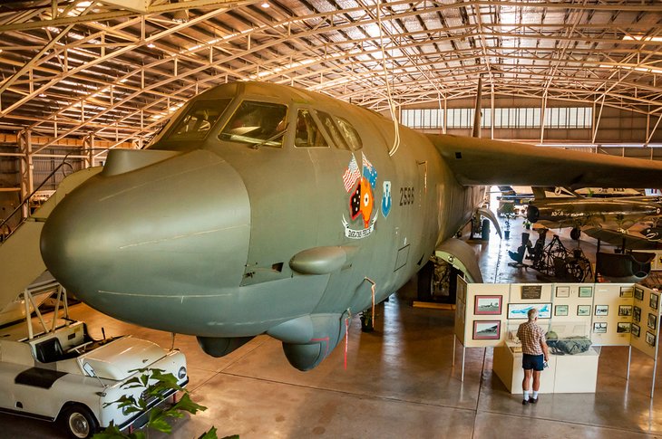
For even more exhibits on the bombing of Darwin, save time to stop by the Darwin Aviation Museum. True to its name, the museum displays a collection of military aircraft, including a B52 Bomber on loan from the US Air Force.
A second key event in Darwin's history was Cyclone Tracy. On Christmas Day 1974, this ferocious storm slammed Darwin with wind speeds of up to 280 kilometers per hour, almost destroying the entire town. You can hear a chilling sound recording of the storm at the Museum and Art Gallery of the Northern Territory. The museum also covers Darwin's maritime and natural history, and art lovers will enjoy the impressive collection of Aboriginal art. Keep a lookout for "Sweetheart," a 5.1-meter-long stuffed crocodile, one of the largest ever captured in the Northern Territory.
Prefer a feel-good museum? Head to the Royal Flying Doctor Service (RFDS) Darwin Tourist Facility on Stokes Hill Wharf. Here, you can learn all about the outback heroes who connect the Northern Territory's remote communities with life-saving medical care.
If gallery gazing is more your style, Mason Gallery (Shop 7/21 Cavanagh Street) displays and sells vibrant Aboriginal artwork with a focus on pieces from the Northern Territory.
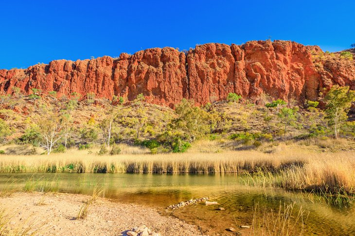
Finke Gorge National Park
Finke Gorge National Park is known for its prehistoric red cabbage palms, which grow in the valley of Palm Creek, a tributary of the Finke River. Extinct elsewhere, the palms are relics of a much wetter period. The imposing rock formations in the park are also of ritual significance to the Western Arrernte Aboriginal people.
Because of its inaccessibility, Finke Gorge National Park drew few visitors until a campground was established on Palm Creek, near Palm Valley. For visitors without an all-terrain vehicle, organized tours depart from Alice Springs.
Alice Springs
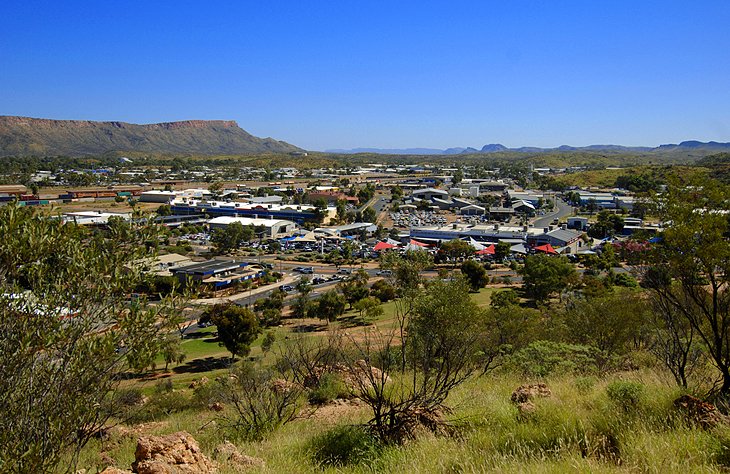
An oasis in the red-earthed desert, Alice Springs is one of Australia's most famous outback towns. Affectionately called "the Alice" by Aussies, it's an important base camp for tours to Red Centre attractions, including Uluru, Kata Tjuta, the MacDonnell Ranges, Kings Canyon, and the boundless expanses of the outback.
Neville Shute's novel, A Town like Alice, and its film version nudged this unassuming town into the international spotlight. Once a dusty outback settlement, today Alice Springs brims with restaurants, hotels, caravan parks, entertainment venues, shops, and Aboriginal art galleries. At the Araluen Cultural Precinct, you can learn about the region's history and Aboriginal culture in a complex of museums and galleries.
Wildlife lovers can meet some famous Northern Territory animals at Alice Springs Desert Park and Alice Springs Reptile Park. And for a dose of local color, try to time your visit for the annual camel races at the end of April and the beginning of May. The greatest event of the year, however, is the Henley on Todd Regatta at the beginning of October. At this famous event, locals trundle boats along the dry riverbed and top off the day with a festival.
Adventures abound in the surrounding countryside. Travelers can hike the Larapinta Trail, one of Australia's most challenging walks, and drive the Red Centre Way from Alice Springs to Kings Canyon. Desert safaris on quad bikes, hot air balloon rides, and camel rides are other popular things to do.
Karlu Karlu (Devil's Marbles Conservation Reserve)
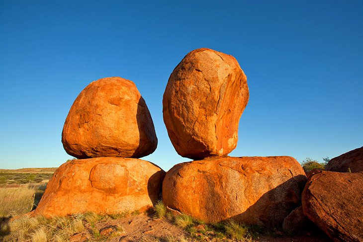
The Northern Territory has no shortage of quirky rock formations, and Karlu Karlu (The Devil's Marbles) grace the list. These huge granite boulders, worn down and split by weathering, are striking landmarks in a flat sandy plain.
In Aboriginal mythology these massive rocks, lying tumbled on the ground or piled on top of one another, are the eggs of the rainbow serpent and are called Karlu Karlu. Their shade and the dew that settles around them provide a habitat for low-growing plants and many birds.
Karlu Karlu are a favorite subject for photographers; arrive just before sunset for the best light.
Official site: https://nt.gov.au/parks/find-a-park/karlu-karlu-devils-marbles-conservation-reserve
Simpsons Gap, West MacDonnell National Park
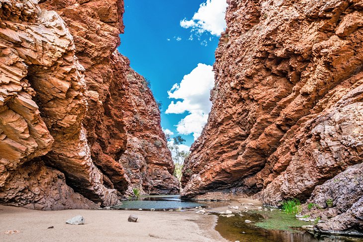
A visit to Simpsons Gap, near Alice Springs, is a great way to experience the rugged topography of the western MacDonnell Ranges. Deep gorges carved by prehistoric watercourses form a striking contrast to the wide desert-like plains and dunes. Areas of white sand, huge river eucalyptus trees, and white-barked ghost gums lead to a permanent waterhole in the shelter of rugged cliffs, which are particularly impressive in the slanting sun of late afternoon.
To the Aranda people who live here, the gorge is the home of their giant goanna ancestors. Walking trails lead to quiet spots where rock wallabies appear in the early morning and late afternoon, and Cassia Hill offers excellent views of the Larapinta valley.
A 24-kilometer hike from Alice Springs Telegraph Station to Simpsons Gap marks the first section of the famous Larapinta Trail, one of Australia's most famous outback walks.
Official site: https://nt.gov.au/leisure/parks-reserves/find-a-park-to-visit/simpsons-gap
Larapinta Trail
One of Australia's top hikes, the legendary Larapinta Trail takes you right through the heart of the Aussie outback. This tough 223-kilometer track follows in the footsteps of the First Peoples, crossing ancient desert landscapes and threading along the craggy spine of the West MacDonnell Ranges.
Starting at the old Alice Springs Telegraph Station, the Larapinta trail is best tackled by experienced hikers. The entire hike takes about 14 days, but you can slice it up into shorter sections to suit your time and ability. Highlights include Simpson's Gap, Ormiston Gorge, Stanley Chasm, and the spectacular views from the summit of Mount Sonder.
Along the way, you'll sleep under the star-spangled desert skies in a swag, or you can pitch a tent at one of the wilderness camps. Guided group tours are the best way to tackle this epic hike.
Official site: http://www.larapintatrail.com.au
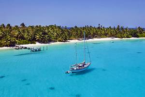
The Tiwi Islands
Aptly called the "Islands of Smiles," the Tiwi islands, about 80 kilometers north of Darwin, are among the top Northern Territory cultural attractions. If you look at a Northern Territory map, these unsung tropical islands sit just north of Darwin and offer a fascinating dose of Indigenous culture, as well as white-sand beaches, dense jungles, and fantastic fishing.
Bathurst and Melville Islands are the only two inhabited islands and are the top destinations for visitors, but the group also encompasses nine small uninhabited islands.
A popular way to visit the Tiwi Islands is on an organized day tour, which starts with a 2.5-hour ferry ride from Darwin. Famous for their vibrant art, the warm and friendly Tiwi people welcome visitors with a traditional song and dance ceremony, and demonstrate artistic techniques like painting, screen printing, and carving in the islands' galleries. Australian Rules Football is also a favorite pastime, and many footie fans visit during March to attend the annual grand final and local celebrations.
Besides aboriginal cultural and art tours, another way to experience the islands is on a fishing trip based out of either Melville Island Lodge, Clearwater Island Lodge, or Johnson River Camp. Barramundi, giant trevally, golden snapper, and jewfish are some of the species found in the rivers and coral reefs.
If you prefer to skip the ferry, flights to the islands take about 25 minutes, but you need to organize a permit well in advance for overnight stays.
Arnhem Land
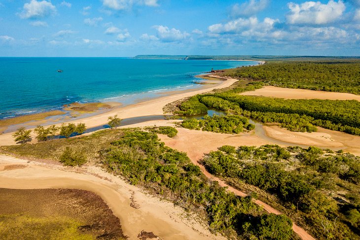
Wondering about unique things to do in the Northern Territory? Add Arnhem Land to your Northern Territory itinerary and learn about one of the oldest living cultures on Earth. Rivaling the size of Iceland, this remote homeland of Aboriginal and Torres Strait Islander people lies about 500 kilometers from Darwin.
The Yolngu people are the Traditional Owners, and with their permission, you can visit here to experience their way of life, admire vibrant Aboriginal art, see ancient rock art sites, and learn how they live off the land.
Make sure you bring a camera. The striking landscapes here will linger long in your memory. Lush greens vibrate against the glowing red earth, and the turquoise Arafura Sea washes up on empty white-sand beaches. The wildlife is also a highlight. Crocs, birds, goannas, kangaroos, and dugongs are just some of the animals you can see here.
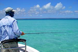
Fishing is another top thing to do in Arnhem Land. In fact, the Cobourg Peninsula is one of Australia's top fishing spots.
Visiting Arnhem Land requires some planning. First, you'll need to organize a permit in advance. Second, decide whether you want to do a DIY trip or join a guided tour. The latter is probably the best way to see all the highlights. No matter how you do it, this trip is one of the best ways to get an authentic taste of this fascinating ancient culture.