Visiting Kakadu National Park from Darwin: Attractions
About a three-hour drive from Darwin, World Heritage-listed Kakadu National Park is one of the most awe-inspiring wilderness areas on the planet. The park is one of the top attractions in Australia's Northern Territory, and it's one of the most popular places to visit from Darwin.
Kakadu is huge. At almost half the size of Switzerland, it's the largest national park in Australia, with more than 20,000 square kilometers of rivers, monsoon forests, mangroves, tropical woodlands, wetlands, and an astounding array of wildlife.
Despite its vast size, visiting Kakadu National Park from Darwin is easy on a self-drive tour. Once you arrive, you can book cruises around the wetlands. Rangers also offer free guided tours during the dry season, and aboriginal-led tours provide a window into the cultural heritage of the park.
If you have limited time and/or prefer to travel with an experienced guide, it's a good idea to choose one of the organized Kakadu tours from Darwin. Although you can explore the park on a day trip from Darwin, it's better to spend at least two to three days here so you can truly appreciate its contrasting landscapes, complex ecosystems, and rich aboriginal history.
Once you arrive in the park, popular things to do in Kakadu include fishing, boating, birding, croc-spotting, hiking, swimming, and camping.
- When to Visit Kakadu National Park
- Self-Drive Tours from Darwin
- Organized Tours in Kakadu National Park
- Professional Tours To Kakadu from Darwin
- Kakadu Landscapes
- Kakadu Aboriginal Heritage and Rock Art
- Kakadu Walks and Hikes
- Kakadu Wildlife
- Kakadu Plants
- Kakadu Waterfalls
- Jabiru
- Kakadu Visitor Centers
- Tips and Tactics: How to Make the Most of Your Visit to Kakadu National Park
When to Visit Kakadu National Park
The best time to visit Kakadu from Darwin is during the dry season, from mid-June to mid-August. Although the wet season (November to March) can be trying, a visit at this time is an impressive experience, with thunderstorms, flooded waterholes, tumbling cascades, and tumultuous rivers. However many roads, tracks, campgrounds, and picnic areas are closed due to flooding.
Self-Drive Tours from Darwin
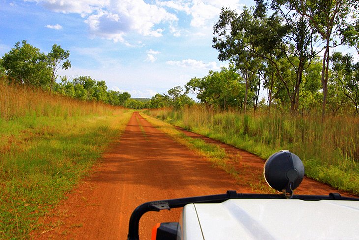
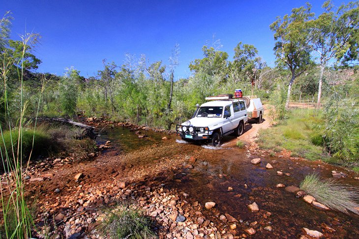
The driving distance from Darwin to Kakadu is about 250 kilometers along the Arnhem Highway on sealed roads. This three-hour drive will bring you to Jabiru, the main settlement and supply center in the park.
On the way, you can enjoy an exhilarating croc cruise on the Adelaide River, about an hour from Darwin, and see these formidable creatures leap from the water. You can also stop by the Window on the Wetlands visitor center to learn more about the ecology of the wetlands in Kakadu National Park and the region's aboriginal history.
From Jabiru, the roads are also sealed to many of the park's top attractions, like Yellow Water and the aboriginal paintings at Ubirr and Nourlangie. If you want to venture further afield and see some of the magnificent waterfalls and more remote attractions, a 4WD is recommended. Most of the big car rental companies have offices in Darwin, and fuel is available at Kakadu Resort (at South Alligator), Cooinda, Jabiru, and Goymarr Tourist Park. Check current road conditions before you head out.
Once you arrive, you can tour the park in your own vehicle or on foot. To see aboriginal rock art, plants, and wildlife up close, you can hike the vast network of trails and enjoy the view from elevated lookouts along the way. To cover larger distances, driving is recommended.
If you have time, you might also want to combine a visit to Kakadu National Park with Litchfield National Park, about a four-hour drive away. Litchfield is a more compact park than sprawling Kakadu, and the mostly sealed roads are easily negotiable in a 2WD vehicle.
Organized Tours in Kakadu National Park
Once you arrive in the park, you can organize tours spotlighting specific areas.
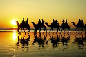
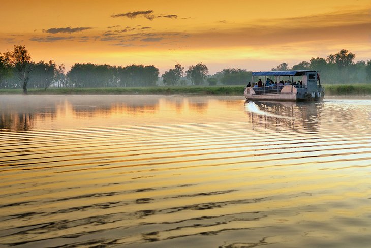
Ranger-led hiking tours and cruises through the wetlands are a great way to learn more about the park and experience areas that are difficult to access. The Yellow Water Cruise in Kakadu is one of the most popular wetlands cruises. Owned and run by indigenous people, the 90-minute cruise is a great way to see some of the wetland wildlife, including crocodiles and a dazzling array of birds, from white-bellied sea eagles to kingfishers and jacanas. Choose your timing - from sunrise to sunset's golden hour. Photographers and birders, in particular, will enjoy this cruise.
The Guluyambi Cultural Cruise on Kakadu's East Alligator River is another excellent option. Aboriginal guides share fascinating information on the river's cultural mythology, the rich ecosystem, and traditional hunting techniques and uses for the plants and animals.
Another wonderful way to see the park is by air. Scenic flights offer an eagle's-eye view of the serpentine waterways and patchwork of floodplains - especially during the wet season, when areas are difficult to access and waterfalls gush over the escarpment. The Jabiru 60 Minute scenic flight, with a guided commentary, soars over key landmarks, including the Alligator River, Jim Jim Falls, and Magela Floodplains.
Professional Tours To Kakadu from Darwin
If you're short on time or want to relax and let an experienced guide do the work, a professional tour of Kakadu National Park from Darwin is a great option. Day trips and multi-day tours take you to the main attractions without the hassle of driving and finding your way. Small-group tours travel in comfortable 4WD vehicles, or you can travel by coach on a larger tour.
Many tours also offer the chance to visit Arnhem Land, a sprawling wilderness area adjacent to the park, which is home to the Yolngu aboriginal people and is only accessible with a permit.
If you're visiting Kakadu on a day trip from Darwin, the Kakadu, Nourlangie and Yellow Water Tour from Darwin is a great way to experience the park's highlights in a limited timeframe, including aboriginal rock art, waterways, and wildlife.
If you have more time, the 2-Day Kakadu and Arnhem Land Tour from Darwin also includes the park's main attractions, such as Nourlangie and a Yellow Water Cruise, and it adds a 4WD tour of Arnhem Land and the Mikinj Valley with an aboriginal guide.
To really absorb the park's natural beauty and cultural significance, the 3-Day Kakadu National Park and Arnhem Land Explorer Tour includes all of the attractions visited on the shorter tours, as well as an East Alligator River cruise. In Arnhem Land, you'll also visit sacred aboriginal sites and learn bush hunting techniques. These multi-day tours offer different standards of Kakadu accommodation to suit your budget.
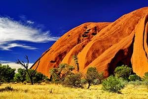
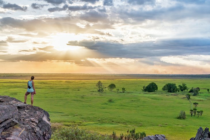
Kakadu Landscapes
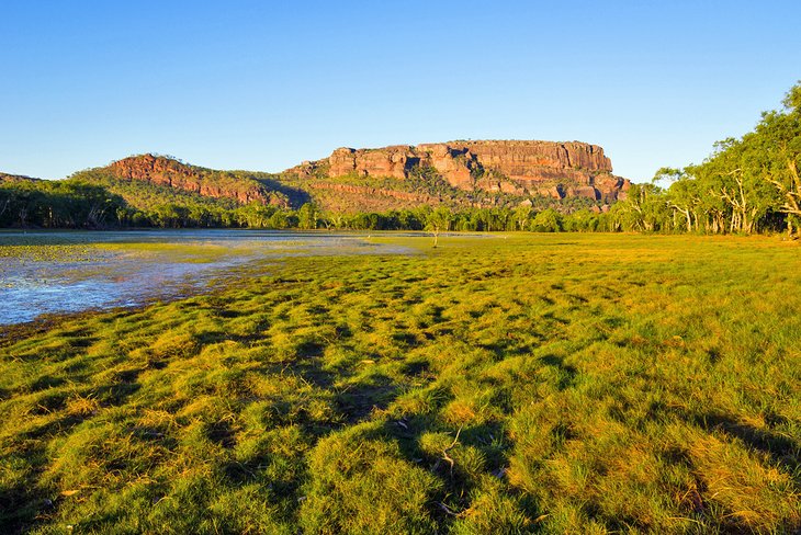
A place of timeless beauty, the park is a giant patchwork of contrasting landscapes. In the north is the tidal zone, where rivers flow to the sea. Monsoon rainforest lies in the gorges and on shady hillsides, where water nourishes the plants.
Farther inland, tropical woodland cloaks the gently undulating upland country and constitutes the greater part of the park. All the main roads run through this area, making it easy to access the sights on a road trip from Darwin. The dry shrubs and grasses here resemble the landscapes of Australia's arid interior.
In the south of the park, where stony upland areas are scattered with crags of granite, plants and animals from the wetter north and the arid interior flourish side by side. Much of the catchment area of the South Alligator River lies in this barren stone country.
Crossing the park diagonally, from the southwest to the northeast, is the escarpment of the Arnhem Land plateau. During the rainy season, waterfalls cascade over the lip of the escarpment to join the wetlands and rivers, which follow a winding course to the sea. During the dry season, the waterfalls and rivers dry up, leaving only rock pools and billabongs (waterholes in the river beds), where many animals come to drink. At the beginning of the dry season, small areas of grassland are deliberately burned to reduce the danger of large-scale fires.
These diverse landscapes are so beautiful that filmmakers shot many scenes for the popular Australian film Crocodile Dundee in Kakadu. The movie provided excellent publicity not only for the park, but for the entire Top End.
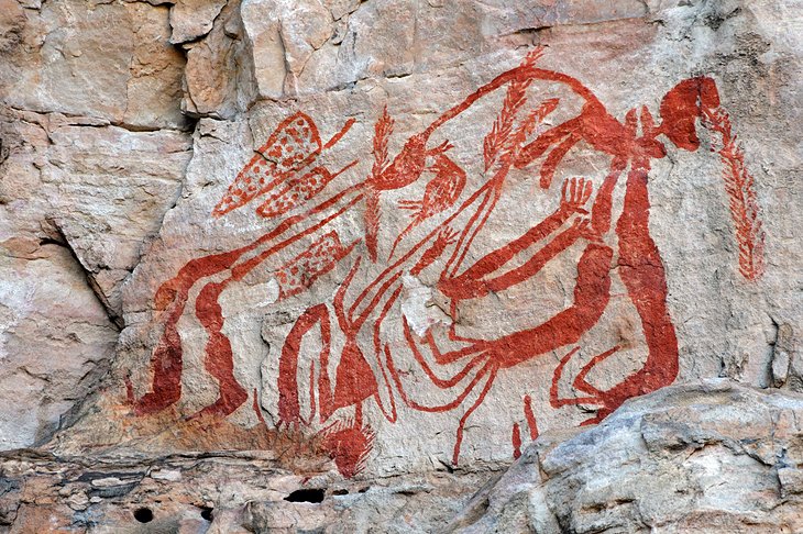
Kakadu Aboriginal Heritage and Rock Art
The name Kakadu comes from Gagadju, one of the languages spoken by the aboriginal tribes, who have lived in this region for at least 50,000 years. Today, more than half of the park belongs to these traditional owners, who jointly manage the area with Parks Australia.
A highlight of Kakadu (and one of the reasons for its World Heritage status) is the magnificent aboriginal rock art. Some of the paintings are more than 20,000 years old, providing a fascinating record of one of the oldest cultures on Earth.
Famous rock art sites include the Nourlangie Rock, south of Jabiru, and Ubirr (Obiri) Rock. Both sites comprise the most important assemblage of Aboriginal art in Australia and are among the park's top attractions.
Side by side, and sometimes superimposed, the paintings portray mythological figures, like the Rainbow Serpent and the Lightning Man, as well as "X-ray" pictures showing the skeleton and internal organs of animals such as barramundis, crocodiles, and turtles. The most recent paintings illustrate encounters with white settlers through representations of two-masted sailing ships, guns, horses, and buffaloes.
At Nourlangie, you can view paintings in the Anbangbang Gallery, or at Nanguluwur, a smaller gallery at the end of a 1.7-kilometer trail. At Ubirr, a one-kilometer circuit walk to view the paintings takes about 45 minutes. Allow an extra 30 minutes to enjoy panoramic views from the lookout. From June to September, rangers give talks at both Ubirr and Nourlangie.
Official site: https://parksaustralia.gov.au/kakadu/do/rock-art/
Kakadu Walks and Hikes
Kakadu's walks are divided into different regions, each offering contrasting landscapes and habitats. Accessibility varies depending on the weather.
If you're a first-time visitor to the park, a great introductory walk is the Jabiru to Bowali Track. The trailhead lies opposite the Gagudju Crocodile Holiday Inn and weaves through woodlands to the Bowali Visitor Centre. From May to October, rangers give free talks here.
In the East Alligator region, you can enjoy panoramic views from Ubirr, admire aboriginal rock art, and explore rainforest and rock pillars. In the South Alligator Region, birds abound around the billabongs and Mamukala Wetlands.
Walks in the Nourlangie region explore the aboriginal art galleries of Nourlangie Rock, as well as the beautiful Anbangbang Billabong. Also in this region, the Bubba Wetlands Walk encompasses tranquil lily-topped ponds.
The Yellow Water region is famous for its boat cruise through the floodplains, but you can also explore the billabong on the Yellow Water Boardwalk.
During the dry season, walks in the Jim Jim and Twin Falls areas lead to Kakadu's waterfalls, which slow to a trickle at this time of year. You can explore rugged gorges and refreshing plunge pools. During the wet season, sightseeing flights allow you to view the falls from the air.
In the Mary River region, bushwalks offer views of gushing waterfalls in the wet season, and sparkling waterholes when the rains cease and the dry season is in full swing.
Kakadu Wildlife
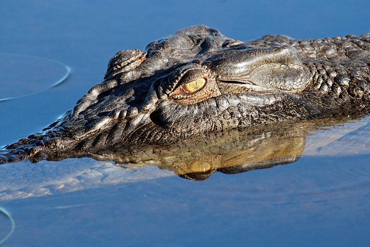
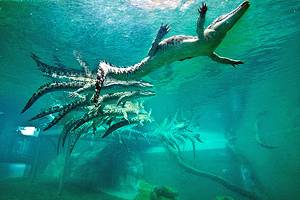
Kakadu National Park is home to a dazzling diversity of wildlife. A quarter of all the species of freshwater fish known in Australia swim in its waters. Animal lovers will also find more than 50 different species of mammals, including rock wallabies, bats, and the northern quoll, as well as a plethora of reptiles; the saltwater crocodile is the largest and most dangerous.
Birding in the park is highly rewarding. The wetlands are important staging posts for migratory birds and provide a home to countless water birds, including the magpie goose, brolga (a species of crane), and jabiru (black-necked stork).
To observe all this wildlife, you can explore the vast network of walking trails in the park. Crocodiles and water birds are best glimpsed by boat.
Kakadu Plants
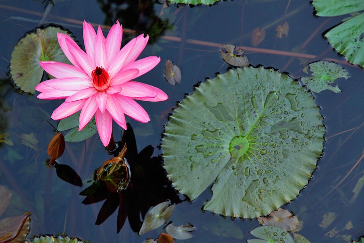
Kakadu protects more than 2,000 plant species - from water lilies to silver-leaved paperbarks. For thousands of years, Aboriginal people used some of these plants for food, medicinal purposes, and weaving materials.
One of the most distinctive and multi-purpose plants in the park is the corkscrew-shaped pandanus, which provides excellent material for weaving baskets and mats. Small animals take shelter under the dead leaves, and the plant's fruit and nuts are important food sources for both animals and people.
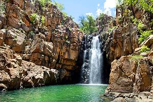
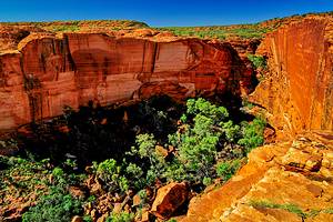
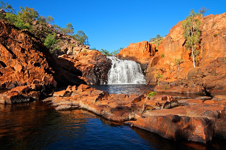
Kakadu Waterfalls
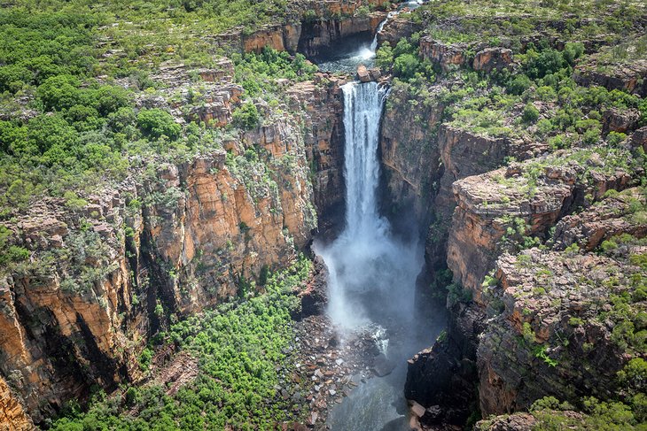
During Kakadu's wet season, water tumbles over the bare rocks and escarpment of the Arnhem Land Plateau creating magnificent cascades. Jim Jim Falls and Twin Falls in the southeast are perhaps the most famous falls in the park. After the rains, visitors can soar over the falls on a sightseeing flight.
In the dry season, when the falls slow to a trickle, the Jim Jim Plunge Pool Walk winds through monsoon forest to a deep waterhole. A great way to see Twin Falls is aboard the boat shuttle, which glides through the gorge from June through October. After the cruise, visitors can view the falls from a floating boardwalk.
Other waterfalls worth seeing include the Maguk Falls (to the south), and Gunlom (Waterfall Creek) accessible via a track, which is sometimes closed during the wet season. Check before departure. Motor Car Falls are accessible in the wet season, when Kakadu's larger falls are off limits.
Jabiru
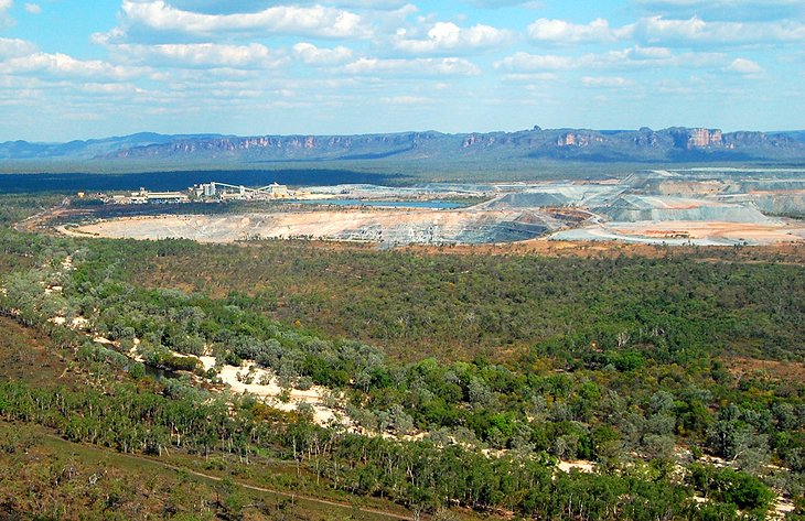
The settlement of Jabiru lies within Kakadu National Park near the Ranger uranium mine, which is slated to close in 2021. The popularity of the national park has made Jabiru an important supply and services center.
Jabiru's main attraction is the Mercure Kakadu Crocodile Hotel. Built in the shape of its namesake amphibian, 250 meters long and 30 meters wide, the hotel is particularly impressive from the air. Its architecture equates with the crocodile totem of the local Gagudju Aborigines.
Kakadu Visitor Centers
Kakadu is home to two visitor centers with informative exhibits on the park. They are also a great place to pick up a Kakadu National Park map.
Bowali Visitor Centre, near Jabiru, is a great introductory stop for newcomers to Kakadu. Walk-through displays provide fascinating information about the park, and you can also browse the library or relax in the café. The Marrawuddi Gallery displays Aboriginal fine art. This is a great place to visit if you want to buy souvenirs, such as arts and crafts and artifacts made in Kakadu or Arnhem Land.
To gain insight into local aboriginal culture, you should stop by Warradjan, near Cooinda, in the Yellow Water region. Built to resemble a Warradjan (pig-nosed turtle), this cultural center displays exhibits and movies on Aboriginal culture in Kakadu, while the gallery sells souvenirs, books, and refreshments.
Tips and Tactics: How to Make the Most of Your Visit to Kakadu National Park
- Look for crocodiles when approaching riverbanks or when fishing and boating. Swimming is off limits in the park.
- Wear sun protection while hiking, and seek shelter in the scorching heat of the day. In the dry season, daytime temperatures averages 30°C and the night averages 17°C
- Bring at least three to four liters of water per person, wear sturdy walking shoes, and consider bringing a topographic map and compass, or a GPS.
- When packing for long hikes, take basic first aid equipment, register the planned route, and advise friends and family of an estimated return time.
- Entry to Aboriginal Arnhem Land (Border Store, Oenpelli) requires a written permit from the Land Council.
- Seasonal flooding may close some sections of the park, especially during rainy season.
- The best time to view wildlife is early morning and around sunset.
- Take binoculars for a close-up view of birds and other wildlife.
- Kakadu is open all year, however seasonal flooding may close some sections of the park - especially during the rainy season.
- For more information on the park see http://kakadu.com.au/