16 Top-Rated Attractions & Places to Visit in South Australia
South Australia has captured the imagination of artists and adventurers for centuries. Sprawling wilderness, a stunning coastline, and stark desert beauty inspire all who visit, and the state capital, Adelaide, sits on the brink of all these natural wonders. Parks and gardens punctuate the city, and venerable 19th-century buildings grace the wide, tree-lined streets of this culture-rich capital. But this sparsely populated state has a trove of other tourist attractions.
Quaint country villages steeped in European charm, emerald hills, and cobalt crater lakes are some of the unique places to visit in South Australia. Along the coast, you can bask on beautiful beaches; picnic in secluded coves; or commune with wildlife on Kangaroo Island, one of the country's much-loved tourist gems.
South Australia is also a haven for foodies. The state's wild seas and picturesque pastoral land, fed by the mighty Murray River, produce a bounty of fresh produce–from citrus fruits and grapes to hand-made cheeses and some of the country's best seafood.
Further afield, in the west and northwest, the arid wilderness meets the pink-tinged peaks of the Flinders Ranges, the opal mines of Coober Pedy, vast deserts crossed by famous 4WD tracks, and the legendary Nullarbor Plain. Find the best places to visit in this diverse Aussie state with our list of the top attractions in South Australia.
- 1. Kangaroo Island
- 2. Adelaide's Art & Culture
- 3. Barossa Valley
- 4. Adelaide Botanic Garden
- 5. Clare Valley
- 6. Flinders Ranges
- 7. The Fleurieu Peninsula
- 8. Glenelg
- 9. The Eyre Peninsula
- 10. Murray River
- 11. Mount Gambier & Umpherston Sinkhole
- 12. Dhilba Guuranda-Innes National Park, Yorke Peninsula
- 13. Coober Pedy
- 14. The Oodnadatta Track
- 15. Adelaide Oval
- 16. Adelaide Central Market
- Map of Attractions & Places to Visit in South Australia
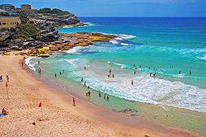
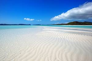
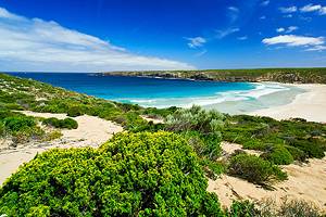
1. Kangaroo Island
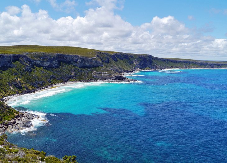
Kangaroo Island off the Fleurieu Peninsula is the third largest island in Australia and one of the country's top natural jewels. This beautiful island is a must-do on your South Australia itinerary.
Sparkling cerulean seas, pristine beaches, rugged coastal scenery, and fascinating rock formations and caves are some of the island's top draws. Top things to do on Kangaroo Island center around these beautiful wilderness areas. Enjoy close-up encounters with the namesake marsupial, as well as koalas, seals, penguins, sea lions, and a diversity of birds in their natural habitat. Surf down giant sand dunes, or dive the clear waters. Scuba divers frequently spot sea dragons in the temperate waters, and many wrecks lie sunken offshore.
In Flinders Chase National Park, the wind-sculpted boulders of the Remarkable Rocks and the eroded curve of Admiral's Arch are striking geographical features. The island is also known for its bounty of fresh produce including fresh seafood, free-range eggs, and Ligurian honey.
Wondering how to get to Kangaroo Island? You can fly direct to the island from Adelaide, or hop aboard a ferry from Cape Jervis on the Fleurieu Peninsula.
2. Adelaide's Art & Culture
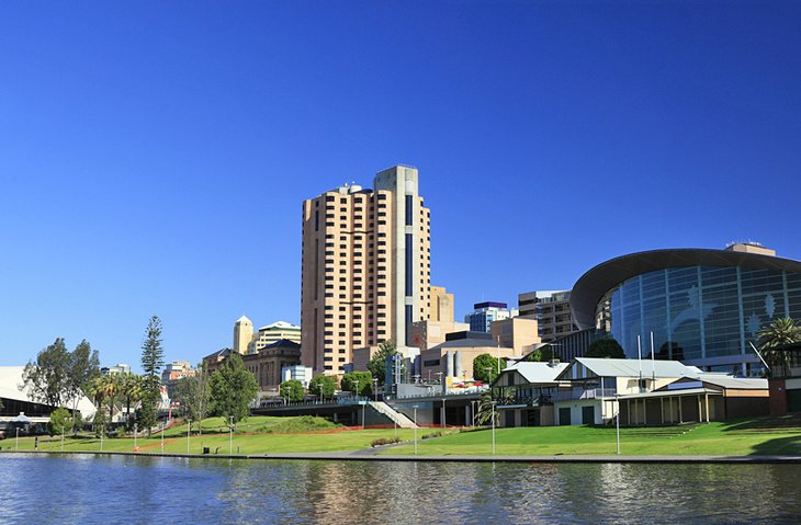
Adelaide, the capital of South Australia, is Australia's fifth-largest city and one of its most charming. Thanks to the city's affluent heritage, arts and culture thrive here – from opera and symphony to a vibrant live music scene.
Culture vultures should head to North Terrace first. Visiting the museums, galleries, gardens, and gourmet restaurants along this beautiful tree-lined boulevard are among the top things to do in Adelaide.
One of the cultural treasures on North Terrace is the Art Gallery of South Australia. Housed in a colonnaded Victorian building, it hosts one of Australia's finest art collections. Other must-sees include the Migration Museum; the State Library of South Australia; and the adjacent South Australian Museum, renowned for its Aboriginal heritage collections.
Adelaide's architectural highlights reside along here, too. Don't miss Parliament House, with its grand colonnade, and the Mitchell Building, on the main campus of the University of Adelaide – it's one of the city's best examples of Gothic Revival style.
Prefer live performances? Opera, symphony, and a flourishing music scene lure aficionados from around the country, and you'll find an impressive line-up of performances and events at the Adelaide Festival Centre.
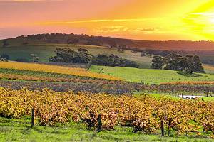
3. Barossa Valley
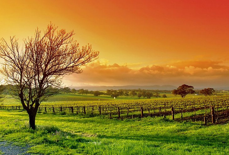
The Barossa Valley, about an hour drive from Adelaide, is a favorite day trip from the capital. Blessed with fertile soils, this verdant valley is one of Australia's oldest grape-growing regions and a haven for foodies, who are lured by the high-quality fresh produce and artisan foods.
German and English immigrants originally settled the valley, and their history and culture is still palpable today in the historic buildings, heritage trails, museums, and European-style cuisine.
In addition to all the historic attractions, the Barossa Valley offers plenty of other things to do. You can shop at the popular farmers markets, attend cookery schools, feast at the fabulous restaurants, relax at the day spas, and browse the many gift shops and art galleries.
4. Adelaide Botanic Garden
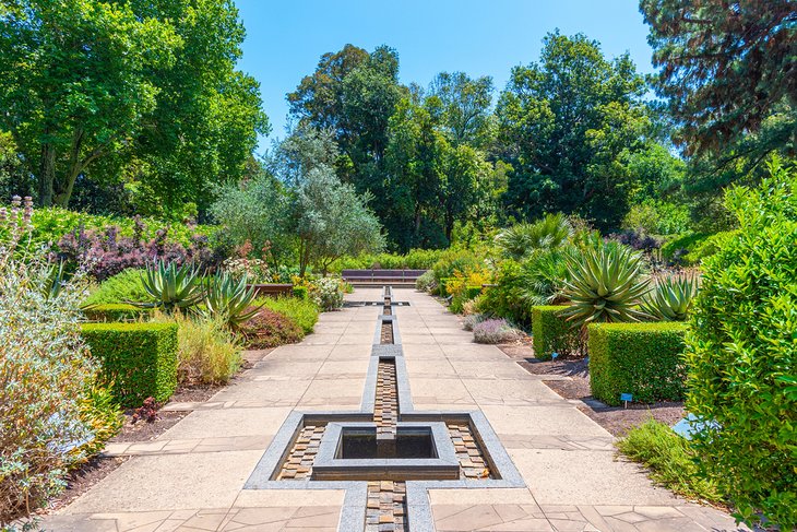
Green thumbs take note: Adelaide Botanic Garden is one of the best free things to do in South Australia. You'll find it at the east end of North Terrace behind wrought-iron gates.
Established in 1855, Adelaide Botanical Garden features a bevy of themed botanical beauties. Medicinal plants, a Mediterranean garden, and Australian native species are among the impressive collections. Interested in water conservation? The garden also hosts a wetland designed to sequester enough water to eventually irrigate the entire grounds.
Save time to visit the Santos Museum of Economic Botany. Here you can learn about the critical role plants play in everyday life.
Other garden highlights include Australia's oldest avenue of Moreton Bay fig trees, the Bicentennial Conservatory, the palm house, and the magnificent night-flowering Amazonica water lilies.
Mini green thumbs will love the Little Sprouts Kitchen Garden with fruit and veggies, compost, and a worm farm.
Still haven't got your green fix? Head to Mount Lofty Botanic Garden to admire cool-climate plants and a heritage rose garden, or get your Zen on at Himeji Garden amid lily-topped ponds and fountains.
Address: North Terrace, Adelaide, South Australia
Official site: https://www.botanicgardens.sa.gov.au/visit/adelaide-botanic-garden
5. Clare Valley
Along with the Barossa Valley, the Clare Valley is another famous Australian grape-growing region, about 136 kilometers north of Adelaide. Picturesque pastoral landscapes provide a perfect setting for romantic weekend retreats, and the region is known for its flourishing gourmet food culture. Polish, English, and Irish immigrants originally settled the valley, and their culture and customs are still evident in the charming heritage towns and historic bluestone buildings.
Named after County Clare in Ireland, the main town of Clare is one of the best country towns in South Australia for a weekend getaway. Explore the region's history in the town's museum, housed in a mid-19th century courthouse, or visit nearby Sevenhill, named for its rolling countryside reminiscent of the hills around Rome. From here, you can take the scenic drive to Polish Hills River Valley and visit the Polish Hill River Church Museum (open the first Sunday of every month), or bike the old railway route.
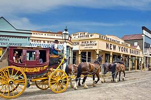
From 1845 to 1877 copper mining brought prosperity to the area around Burra, which has preserved its rich history in mine buildings, stone dwellings, and museums along Burra's Heritage Passport Trail. The English-style heritage town of Mintaro is home to Martindale Hall, a Georgian-style mansion, which you can tour.
Popular things to do in the Clare Valley include exploring the beautiful Skilly Hills; dining at the excellent cafés and restaurants; and browsing the local markets, gift shops, and art galleries. Each year in May, foodies flock here for the annual Clare Valley Gourmet Weekend, a celebration of the region's abundant fresh produce.
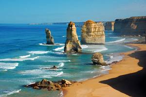
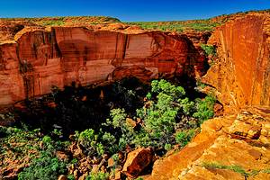
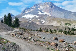
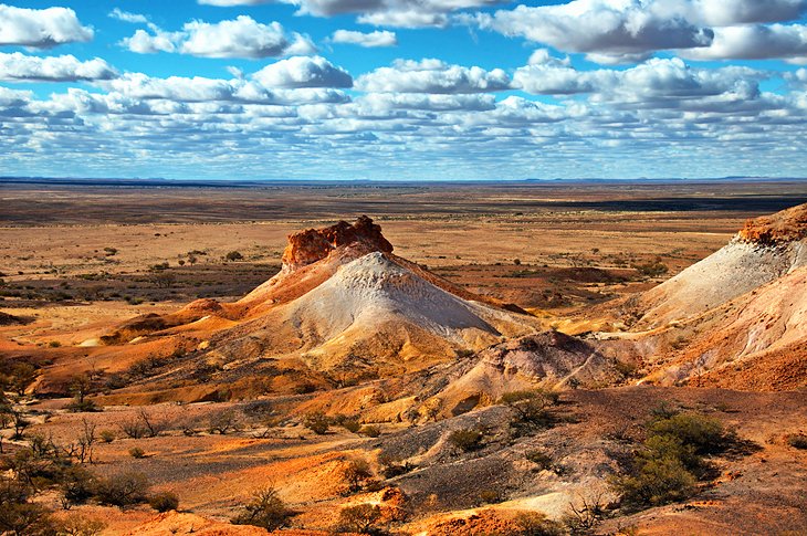
6. Flinders Ranges
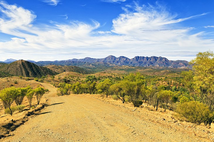
Named for famous explorer Matthew Flinders, the Flinders Ranges are a delight for nature lovers, photographers, and artists. In the shifting light of day, the arid landscapes provide a striking play of colors–from pale pink and burnished gold to vibrant burnt orange.
Despite the dry conditions, the area is home to a surprising abundance of wildlife. Emus, yellow-footed rock wallabies, and flocks of brilliantly colored parrots are frequently spotted.
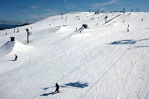
The mountains run from north to south through the eastern part of South Australia, stretching northward for 400 kilometers into the scorched outback. Due to the high summer temperatures, it's one of the best places to visit in South Australia during winter. In Flinders Ranges National Park, the most scenic area of the region, a rich growth of vegetation cloaks the sheltered valleys, and wildflowers carpet the parched earth in spring, which is another great time to visit.
Top tourist attractions in the Flinders Ranges include the natural amphitheater of Wilpena Pound with St. Mary's Peak at its highest point, Aboriginal art at Arkaroo Rock, and interesting fossils. You can also hike part of the long-distance Heysen Trail, named for the famous German-born Australian artist, Hans Heysen.
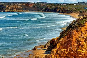
7. The Fleurieu Peninsula
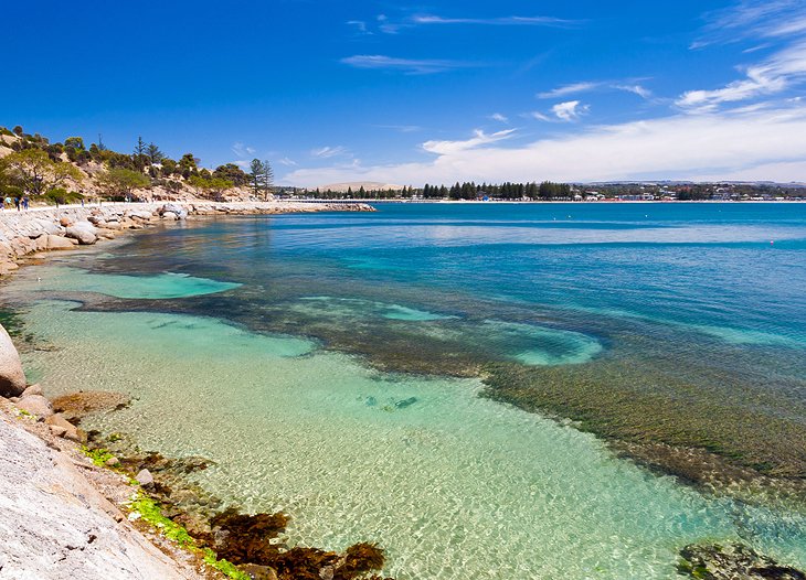
The picturesque Fleurieu Peninsula sits on a spur of land projecting southwest from the Mount Lofty Ranges. It's a popular place to visit for foodies and outdoor enthusiasts. Fishing, boating, bushwalking, whale watching, surfing, and swimming are just a few of the things to do here on and off the water.
Nature is a star attraction in the Fleurieu Peninsula. Beautiful scenery, wildlife reserves, and superb beaches lure visitors here year-round. The sheltered sandy inlets in Gulf St. Vincent are ideal for a relaxing day by the sea.
Victor Harbor is one of the most popular beach resorts on the peninsula. Connected by a long causeway, Granite Island, protects it from the turbulent Southern Ocean and is a haven for kangaroos and penguins.
Goolwa is another favorite destination. It sits on the narrow channel at the outlet of Lake Alexandrina, into which the Murray River flows. In its heyday, it was known as the "New Orleans of Australia" because of the numerous paddle steamers plying the river. Off Goolwa, Hindmarsh Island is a favorite haunt of bird-watchers.
Other popular places to visit on the Fleurieu Peninsula include the surfing hot spot of Port Elliot and the vine-draped hills of McLaren Vale, a prime grape-growing region. Exploring these areas is one of the top things to do south of Adelaide.
From Cape Jervis, at the tip of the peninsula, tourists can hop aboard a ferry service to Kangaroo Island.
8. Glenelg
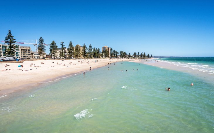
Calm waters, soft white sand, family-friendly attractions, and a fascinating history are the top reasons to visit Glenelg. It's only a 25-minute trip from Victoria Square in Adelaide, and the journey is as fun as the destination. Most people take the Glenelg tram, Adelaide's only surviving tram, right to the beach. Best of all, the trip is free.
Glenelg is the oldest European settlement on mainland South Australia, and it's not hard to see why these free settlers disembarked here. One of the top attractions is the beautiful white-sand Glenelg Beach, lapped by the calm waters of Gulf St. Vincent.
Traveling with kids? Take them to The Beachouse, an amusement park with exhilarating rides, including a giant waterslide, bumper boats, and a Ferris wheel, and stroll along Glenelg Pier with an ice-cream cone in hand.
Aquatic activities are also popular in this picturesque seaside village. Cast a fishing line off the pier, go sailing, or book a dolphin spotting cruise.
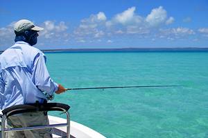
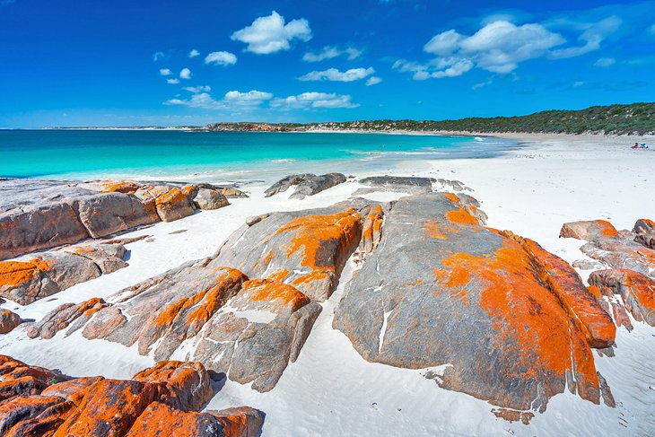
9. The Eyre Peninsula
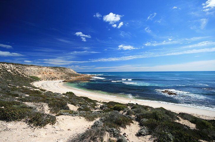
Rimmed by a rugged and ravishing coastline of cliffs and sheltered beaches, the triangular-shaped Eyre Peninsula is one of Australia's least crowded coastal stretches. It's also one of its most beautiful.
The Eyre Peninsula is located east of the Great Australian Bight. Water sports are a top thing to do here, and cage diving with great white sharks scores top billing on the list of aquatic adventures. You can also snorkel with giant cuttlefish near Whyalla, or swim with balletic sea lions at Baird Bay. Whale watching is another popular activity during May through October, when southern right whales migrate along the Great Australian Bight Marine Park.
Coffin Bay is known for its superb seafood and stunning national park. Occupying the southern tip of the Eyre Peninsula, Lincoln National Park offers spectacular scenery with rugged cliffs and abundant birds, and Port Lincoln is becoming an increasingly popular holiday resort. Its fishing fleet, the largest in Australia, produces some of the country's best seafood.
Inland, you can explore the bushland and wildlife of the Gawler Ranges, or venture into the outback across the legendary Nullarbor Plain for a serious 4WD adventure through the scorched desert.
10. Murray River
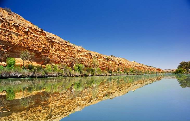
The mighty Murray is Australia's longest river. It flows from its source in the New South Wales Alps to the Southern Ocean in South Australia. Sandstone cliffs and tall eucalyptus trees fringe the river, and its wetlands are important habitats for many water birds.
Once home to the Ngarrindjeri and Nganguraku people, today the river irrigates a vast citrus-growing industry and agricultural region and provides a wealth of water-based activities, from fishing, boating, water-skiing, and swimming to gliding along on a paddle steamer.
Peppered with colorful gardens and fragrant roses, the riverside town of Renmark lies at the point where the states of South Australia, New South Wales, and Victoria meet and is home to huge plantations of citrus fruits. From here, you can tour the Olivewood Historic Homestead and Museum, organize a river cruise, or hire a houseboat.
Another popular place to visit is Loxton. The "garden city" of the Riverland region brims with galleries and historical sites. Here, on the banks of the river, the Historical Village takes visitors back in time with a faithfully recreated late-19th century buildings and artifacts.
Northwest of Loxton, the little town of Waikerie is a popular spot for gliding, and offers a pretty cliff-top walk.
11. Mount Gambier & Umpherston Sinkhole
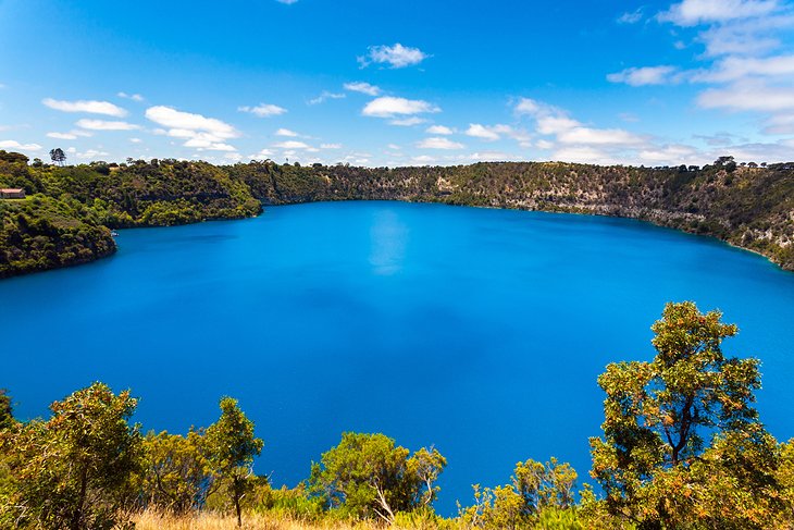
Located along the Limestone Coast, Mount Gambier is an extinct volcano with four beautiful crater lakes, as well as sinkholes and gardens. A curious natural phenomenon occurs on the Blue Lake annually in November. The color of the lake transforms from dull gray to a brilliant cobalt blue. A scenic drive with spectacular views runs round the crater.
While you're in the area, stop by the Umpherston Sinkhole. Created when the roof of a cave collapsed, this popular tourist attraction was transformed into a beautiful "sunken garden" by James Umpherston in the 1880s. Ferns, hot pink hydrangeas, and calla lilies flourish in the gardens, and lush plants cascade over the lip of the sinkhole, imbuing the space with a magical feel. In the evenings, lights illuminate the gardens, and friendly possums congregate here looking for a meal.
South of Mount Gambier, you can explore South Australia's only World Heritage Site: Naracoorte Caves. This is one of those hidden places in South Australia that is worth visiting – especially for its fascinating fossils. But you'll also see colonies of bats, and haunting subterranean scenery.
Other attractions on the Limestone Coast include the grape-growing region of Coonawarra, the former whaling station of Beachport, and the historic beach resort of Robe. Nature lovers will also enjoy the bird-rich lagoons and coastal dunes of the Coorong, a chain of lagoons and salt lakes between Lake Alexandrina and the sea.
12. Dhilba Guuranda-Innes National Park, Yorke Peninsula
Remote and refreshingly uncrowded, Innes National Park is an under-rated, raw slice of nature. It sits at the tip of the spectacular Yorke Peninsula, about a three-hour drive from Adelaide. If you look at a South Australia map, the Yorke Peninsula is the boot-shaped claw of land jutting out to the west of Adelaide, and it makes a wonderful weekend getaway from the capital.
Rugged seascapes, wildlife, and windswept white-sand beaches lapped by dazzling blue seas are the prime attractions. You can explore the park on hiking trails or by car, stopping at the empty beaches along the way.
Popular things to do in Dhilba Guuranda-Innes National Park include surfing the remote breaks, camping, boating, fishing off the ravishing beaches, and diving the many wrecks scattered along this tempestuous stretch of coast. To learn more about the region's fascinating shipwreck history, visit the rusted hull of the Ethel, and follow the maritime interpretive trail along the coast.
Wildlife is abundant. Emus and kangaroos are among the most frequently spotted animals in the park, and you might also spot southern right whales, dolphins, seals, and sea lions off the coast. The park is also home to more than 150 species of birds, including ospreys, malleefowl, and hooded plovers.
Official site: https://www.parks.sa.gov.au/find-a-park/Browse_by_region/Yorke_Peninsula/innes-national-park#see-and-do
13. Coober Pedy
The opal-mining town of Coober Pedy lies in the heart of the South Australian outback. The name of the town comes from an Aboriginal phrase meaning "white fellows in a hole." It's an appropriate name since most of the inhabitants live in underground dwellings (dugouts) to escape the fierce heat of summer and the extreme cold of winter. This is definitely not one of the top things to do in South Australia in December or January when the summer temperatures soar.
In 1911, gold miners found valuable white opals here. Since then, opal mining has converted the desolate countryside around Coober Pedy into a lunar-like landscape. To capture some beautiful photos of this stark beauty, head to Kanku-Breakaways Conservation Park. It's home to haunting, arid landscapes and around 60 native plants, as well as red kangaroos, echidnas, and numerous birds.
Want to find some opals? You can still try your luck looking for these pearlescent beauties after obtaining a prospecting permit from the Mines Department in Coober Pedy.
The Old Timers Mine & Museum displays exhibits on the history of prospecting for precious stones. Sightseers can also tour underground homes and the subterranean Catacomb Church.
14. The Oodnadatta Track
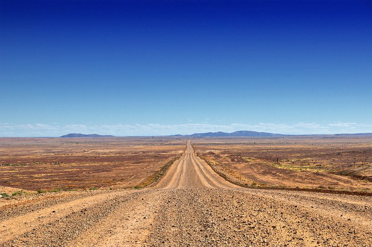
If you're up for a rugged South Australia road trip, look no further. The legendary 620-kilometer Oodnadatta track is one of the most unique things to do in South Australia. It cuts through the heart of this vast state, following the historic route of the old Ghan Railway. Rust-red desert, otherworldly moonscapes, and weather-beaten outposts provide eye-popping photo ops along the way, and the wide-open spaces evoke an exhilarating sense of freedom.
Highlights include the quirky town of William Creek. With a population of around 10 people, it looks like it could be a movie set from Crocodile Dundee. You can also soak in artesian springs; camp by remote waterholes; and drive by Lake Eyre South and the largest cattle station in the world (it's larger than Belgium).
The Oodnadatta Track starts at Marree in South Australia and stretches northwest through the tiny outback town of Oodnadatta before circling back to the Stuart Highway at Marla. A 4WD vehicle is highly recommended. This is one of the top things to do in South Australia in winter, when the temperatures are milder.
15. Adelaide Oval
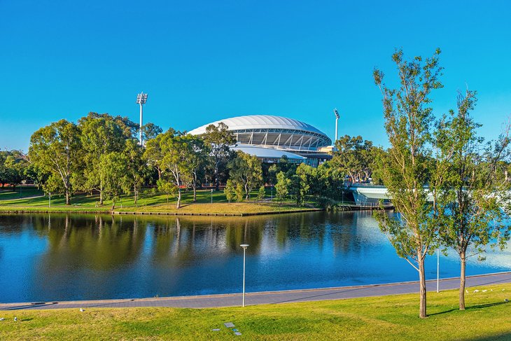
Adelaide Oval is more than just a sports stadium, It's a much-loved part of the city's history.
Established in 1871, the stadium sits in the center of Adelaide's Riverbank Precinct. Its first test cricket match was played here in 1884, and it has since hosted more than 16 different sports, including AFL, cycling, hockey, lacrosse, archery, and tennis. You can also catch a music concert here.
Book a tour to get the most out of a visit to this historic venue. Highlights include the old heritage-listed scoreboard and century-old Moreton Bay fig trees.
Better still, if you have time, catch a cricket match or AFL game here, or buy tickets for a special event.
Are you a cricket fan? Stop by the Bradman Museum to see memorabilia on the life of Australia's most famous cricketer. if you're looking for unique things to do in Adelaide, this is a top option.
Official site: https://www.adelaideoval.com.au/
16. Adelaide Central Market
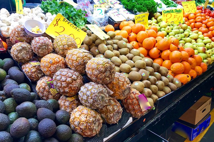
Adelaide Central Market is a shopping institution. Founded in 1870, it's one of the oldest indoor markets in the world. Come hungry. The stalls here brim with fresh fruit, veggies, baked goods, cheeses, health food, meat, seafood, and a tantalizing array of culinary treats. It's also a wonderful place to purchase a vibrant bouquet of flowers.
Prefer to eat sitting down? You'll find some of Adelaide's top cafés and restaurants here, and Chinatown is right nearby with even more culinary gems.
Market days are Tuesday through Saturday. But for the best bargains, try to visit on Saturday afternoons, when some vendors cut prices. Don't forget to bring your own shopping bags or baskets.
Location: Between Gouger and Grote Street, Adelaide, South Australia
Official site: http://www.adelaidecentralmarket.com.au/