16 Top-Rated Day Trips from Glasgow
The city of Glasgow sits in an enviable position. Not only is it within easy reach of many of Scotland's most popular tourist attractions, there are also no end of fun things to do within an easy day trip of the city. And best of all, many of them are easily accessible via public transport, as Glasgow and its surrounds boasts a superb transportation network.
From here, great places to visit include the Scottish Highlands, Robbie Burns country along the Ayrshire coast, Aran Island, as well as Oban. And, of course, famous Loch Ness is within reach, although you may want to make an overnight stay of it (it's doable, but is a three-hour drive away).
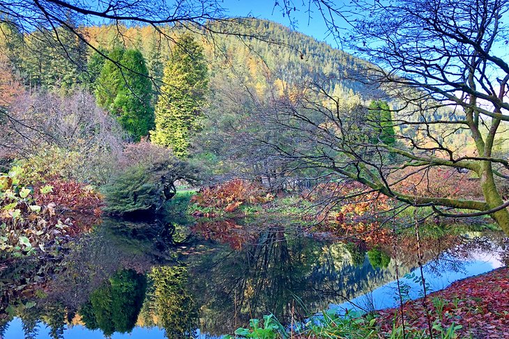
Beautiful Loch Lomond is even closer and is popular for outdoor enthusiasts for its hiking and biking adventures. Stirling Castle, along with a number of equally attractive castles and manor houses, is also within easy reach of Glasgow.
Whatever season you visit, if you do ever tire of Glasgow's lively cultural and music scene - or simply want to experience a different side of Scotland - there are plenty of options for spending time outside the city.
Plan your adventures with this list of the best day trips from Glasgow, Scotland.
- 1. Loch Ness and the Scottish Highlands
- 2. Loch Lomond and the West Highlands
- 3. Stirling and Stirling Castle
- 4. Isle of Arran: Scotland in Miniature
- 5. Outlander Day Tour from Glasgow
- 6. Benmore Botanic Garden
- 7. Newark Castle
- 8. The Ayrshire Coast: Robbie Burns Country
- 9. Dumbarton Castle
- 10. Oban and the West Highlands
- 11. The Hill House, Helensburgh
- 12. The Forth and Clyde Canal and the Falkirk Wheel
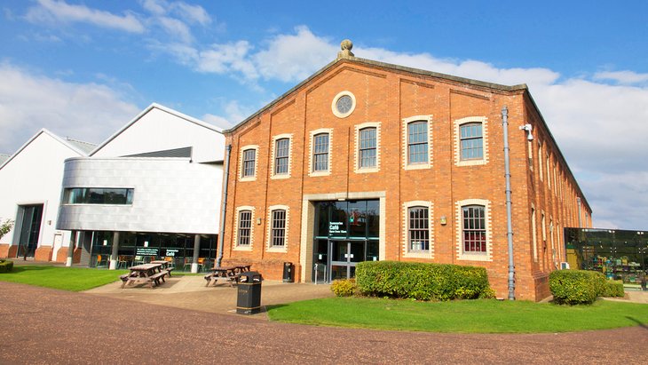
- 13. Summerlee Museum of Scottish Industrial Life
- 14. Paisley Abbey and the Thomas Coats Memorial Church
- 15. Gourock: Granny Kempock's Stone
- 16. Greenock
- Map of Day Trips from Glasgow
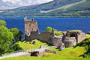
1. Loch Ness and the Scottish Highlands
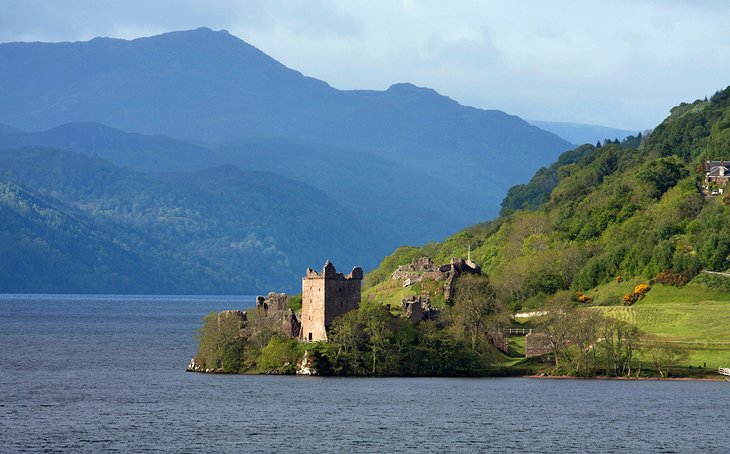
What trip to Scotland would be complete without visiting Loch Ness, home of the fabled sea serpent, Nessie? While it's a lengthy three-hour drive from Glasgow, it should certainly rank near the top of your Glasgow day trips list.
This spectacularly beautiful 23-mile-long and extremely deep body of water fills the geological fissure known as the Great Glen, whose steep green walls make it one of Scotland's loveliest sights. Hour-long boat trips from Fort Augustus or Inverness, or scenic drives along the loch's shore reveal stunning vistas of the rocky peaks of the Scottish Highlands.
Tours to Great Glen, such as the 12-hour Loch Ness, Glencoe & the Highlands Small Group Day Trip from Glasgow, stop in the remote and atmospheric Glencoe, scene of the historic massacre of the MacDonald clan in 1692. The entire region is filled with breathtaking scenery of high mountains, rocky ridges, fast-running rivers, and tumbling waterfalls.
2. Loch Lomond and the West Highlands
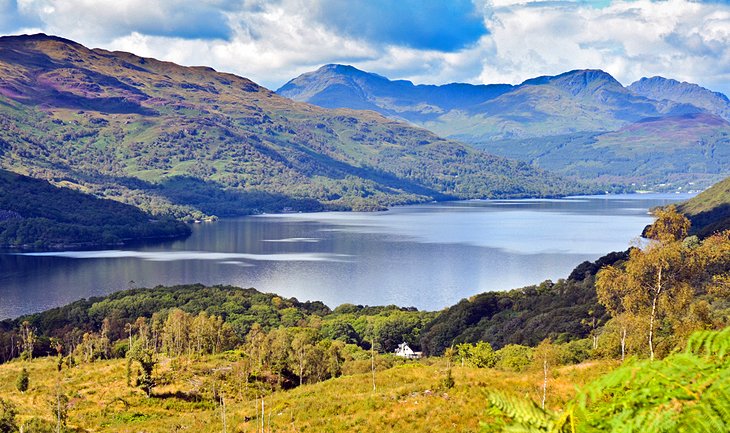
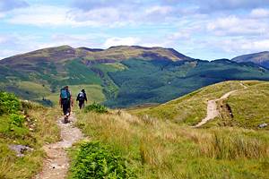
"Yon bonnie banks and yon bonnie braes" of Scotland's largest freshwater loch are only half an hour from Glasgow, at the southern end of Loch Lomond & the Trossachs National Park. In fact, so pretty are the lochs and mountains here that they've earned the park the nickname "The Highlands in Miniature."
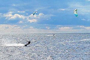
In addition to the haunting beauty and romantic vistas that this traditional Scottish song speaks of, Loch Lomond is a center for outdoor adventures. Boaters and other water sports enthusiasts are drawn here, as are golfers, who head for the Carrick Golf Course at Cameron House. Here, you'll find one of Scotland's finest championship-standard golf courses, boasting incredible views of Ben Lomond across the waters of the loch.
Hiking and bicycle trails abound throughout the park, and Loch Lomond cruises depart from Balloch at the southern end of the lake. Balloch is also where you'll find the Loch Lomond Shores shopping area, as well as the SEA LIFE Aquarium, one of the region's top family attractions.
Although you can easily reach the loch by train, Loch Lomond is often part of tours of the West Highlands from Glasgow. The full-day guided West Highland Lochs, Glencoe and Castles Small Group Day Trip from Glasgow includes attractions such as Kilchurn Castle, the town of Inveraray, and Castle Stalker on Loch Laich.
Official site: www.lochlomond-trossachs.org/
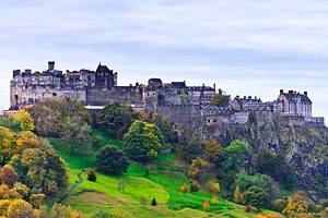
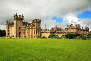
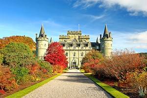
3. Stirling and Stirling Castle
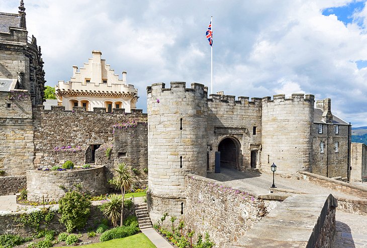
Just 30 minutes from Glasgow by car or direct train, the town of Stirling is famous as the location of the Battle of Bannockburn. It was here in 1314 that Robert the Bruce defeated the English invaders. It was also where legendary William Wallace beat the English at the Battle of Stirling Bridge, a victory for Scottish independence. Both these important battles are commemorated at the excellent Bannockburn Heritage Centre.
Between Stirling and the quaint village of Bridge of Allan stands the majestic Wallace Monument, a spectacular 246-step tower with sweeping views of the area, as well as artifacts that belonged to Wallace.
The spectacular 12th-century Stirling Castle, built atop a 76-meter-high volcanic crag, has played an important role throughout Scotland's rich history and is open to visitors. You can visit Stirling and the castle and also enjoy the beautiful scenery of the Trossachs on the Loch Lomond and Stirling Castle Tour from Glasgow.
Address: Castle Wynd, Stirling, Scotland
Official site: www.stirlingcastle.scot
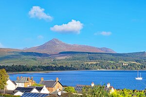
4. Isle of Arran: Scotland in Miniature
The lovely Isle of Arran is only 267 square kilometers in size but contains examples of just about everything that makes Scotland one of the world's most popular tourist destinations. It's for this reason that the island has earned the nickname, "Scotland in Miniature."
Just a one-hour ferry ride from Ardrossan, which itself is an easy train trip from Glasgow, Arran is marked by magnificent mountains, moorland, sandy beaches, an abundance of wildlife, castles, and fishing harbors. It's also a popular golf destination, and offers three great courses.
Arran is also a walker's paradise, and buses run regularly around the island from the ferry terminal at Brodick to its various tourist attractions. Although the best places to visit on Arran – including Brodick Castle and Goat Fell mountain (873 meters) – can be seen in a day (including the ferry ride), you'll want to spend at least a few days exploring this wonderful part of Scotland.
5. Outlander Day Tour from Glasgow
Fans of the hit TV series, Outlander, will definitely be interested in adding a great tour of the series' film locations to their Glasgow travel itinerary. The popular Outlander day tour from Glasgow is an immersive eight-hour adventure departing from central Glasgow that features stops in a number of spots fans will instantly recognize.
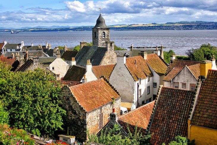
For many, a highlight of the tour is the chance to visit the picturesque village of Culross, which stood in for the fictional Crainesmuir. It's the last stop of the tour, and you'll have plenty of time to explore the old village square, which dates from the 1600s, as well as a historic home dating from the same period.
The attractive Doune Castle is another notable location you'll visit. This remarkably well-preserved medieval fortress starred as Castle Leoch in Outlander, and you'll have plenty of time to explore it armed with a great audio-guide (provided).
The village of Falkland is also on the itinerary, where you'll have a chance to grab a bite of lunch and explore at your leisure. Also included are stops at Blackness Castle and Midhope Castle. Inclusions with this tour are transportation and the services of a professional guide.
6. Benmore Botanic Garden
Benmore Botanic Garden, set amidst spectacularly rugged mountain scenery north of Glasgow at the southern end of Loch Eck, is part of Edinburgh's Royal Botanic Garden. The avenue of giant Californian redwoods planted in 1863 line the long driveway to the property, where you'll be rewarded with a chance to wander around more than 300 different species of rhododendron and azaleas.
Other highlights include Puck's Hut, a wooden memorial to Isaac Bayley Balfour who had the idea to create the gardens, and a bronze statue dating from 1875, A Boy with Two Dolphins, donated by the owner of adjacent Benmore House, now an outdoor learning center.
Nearby Argyll Forest Park is also well worth checking out. Established in 1935, it was the first of its kind in Britain and boasts an impressive 186 mile network of footpaths.
Location: 4 Uig, Benmore, Dunoon, Scotland
Official site: www.rbge.org.uk/visit/benmore-botanic-garden/
7. Newark Castle
In the industrial town of Port Glasgow, just 25 miles west of Glasgow's city center, stands the 15th-century Newark Castle. This attractive mansion, with its gatehouse and tower, was once the seat of the (sometimes murderous) Maxwell family.
Although the Tower House rooms are not open to visitors, you can see the building's lovely Jacobean exterior and the fascinating "below stairs" rooms. Here, interesting exhibits relate to the working conditions and lives of the family's staff.
Address: Castle Rd, Port Glasgow, Scotland
Official site: www.historicenvironment.scot/visit-a-place/places/newark-castle/
8. The Ayrshire Coast: Robbie Burns Country
Fans of the poetry and songs of Robbie Burns, Scotland's beloved national poet, will want to explore the places he lived and the countryside he immortalized. At the same time, you'll see one of the most beautiful coastal regions of Scotland.
Follow the Burns Heritage Trail from the Robert Burns Birthplace Museum in Alloway, on the outskirts of Ayr, where you'll see the beautifully preserved thatched house where the poet was born and lived as a child.
After visiting the 16th-century Auld Kirk where his father is buried, this circular tour heads south to Dumfries and the Robert Burns House, where the poet lived for the four years before he died here in 1796, at age 36. The house is now a museum and gives a good portrait of his life. His grave is in the nearby St. Michael's Churchyard.
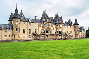
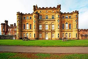
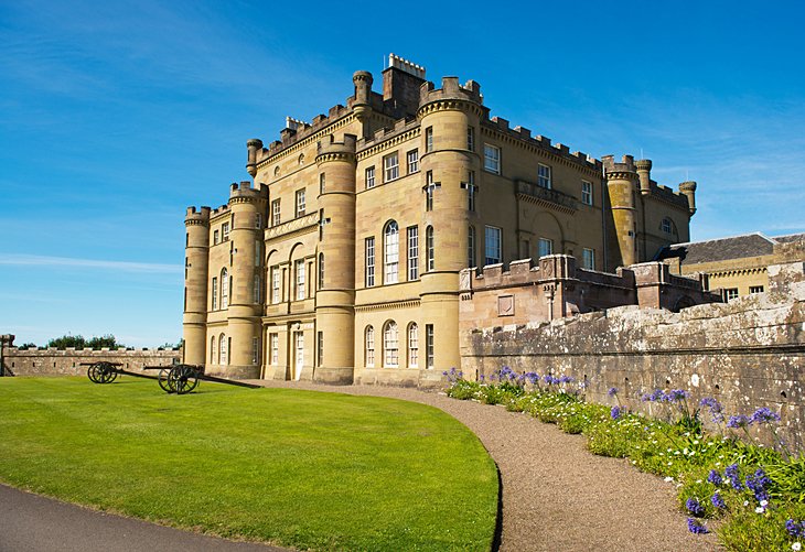
Another highlight of the Ayrshire coast is Culzean Castle and Country Park, with woodland trails and landscaped gardens that include a Victorian Walled Garden. You can visit the Burns sites and Culzean Castle on the Ayrshire Coast Day Trip from Glasgow: Robert Burns Country and Culzean Country Park tour, with a guide who will tell more about Burns and Culzean castle, including its connections with President Eisenhower at the end of World War II.
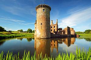
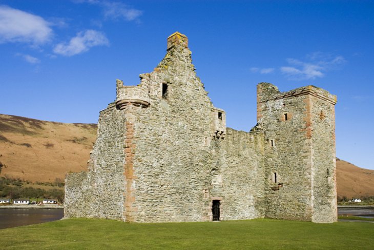
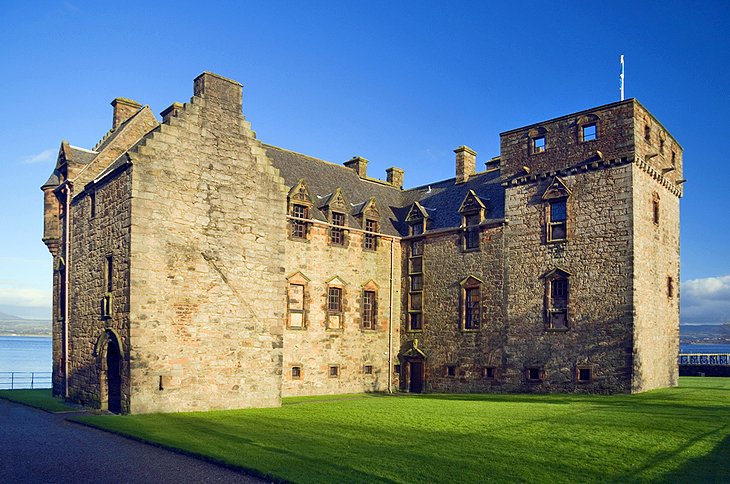
9. Dumbarton Castle
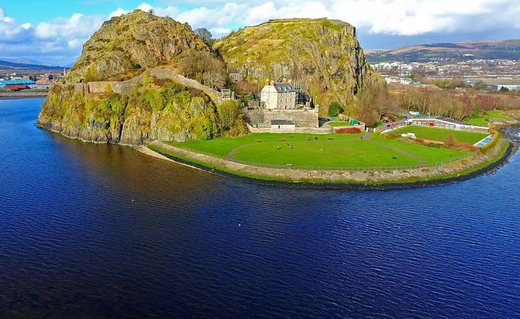
Dumbarton Castle perches dramatically on a basalt rock on the north bank of the Clyde facing Port Glasgow. This strategically important stronghold was started in the 6th century and was central to the ancient kingdom of Strathclyde's rule over the surrounding area until 1018. Only the dungeon and 12th-century gateway remain of this medieval edifice where Mary Stuart embarked for France at age five.
Other highlights of this star of the Game of Thrones series include the wonderful views, the Georgian artillery fortifications, and the Governor's House with its interesting artifacts from the castle.
Address: Castle Road, Dumbarton, Dunbartonshire, Scotland
Official site: www.historicenvironment.scot/visit-a-place/places/dumbarton-castle/
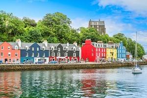
10. Oban and the West Highlands
The pretty Victorian town of Oban, the seafood capital of Scotland, sits on the coast and is the main port for the ferries that connect southern Scotland to Mull, Skye, and the Hebrides islands.
For a view that encompasses the town and harbor and reaches all the way to the Isle of Mull on clear days, climb to the top of McCaig's Tower. This impressive Victorian monument was built to resemble the Colosseum in Rome.
The route to Oban from Glasgow passes through some of Scotland's most scenic countryside, a land of mountains, moors, lochs, and castles. On the Oban and the West Highlands Day Trip from Glasgow, you'll ride through this scenic land, along the shores of Loch Fyne, Loch Awe, and Loch Lomond, where you'll stop in the village of Luss.
- Read More: Top-Rated Attractions & Things to Do in Oban
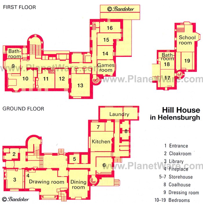
11. The Hill House, Helensburgh
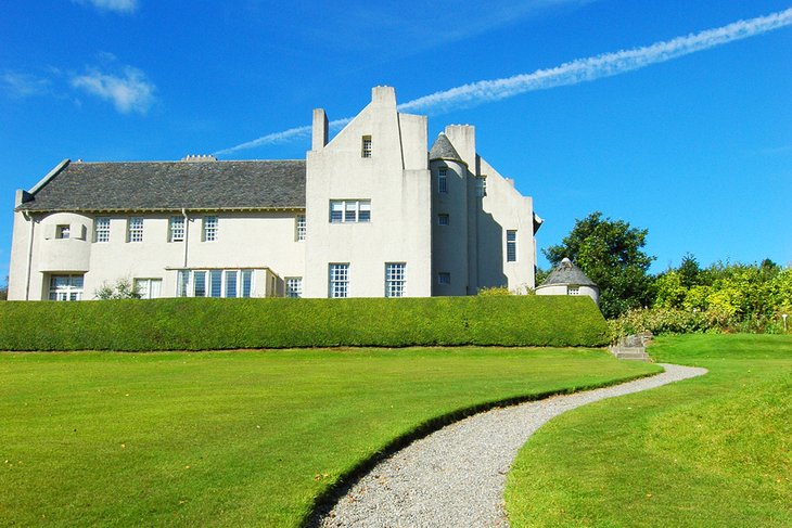
Lovers of Art Nouveau styling won't be disappointed by a visit to Hill House in Helensburgh. Designed by Charles Rennie Mackintosh after plans were drawn up for his Art Lover's House, Hill House was built in 1904 overlooking the Firth of Clyde.
Surrounded by a delightful garden, the house is somewhat reminiscent of Scottish fortified manor houses, while the figural elements, rounded edges, oriel windows, and small chimney stacks bear all the hallmarks of the gifted designer.
The home is currently the subject of an ambitious renovation project that has resulted in it being encased in a large steel frame. Called the "Hill House Box," this impressive structure - anticipated to be in place for up to 15 years - is something of an architectural wonder in itself. Built to keep the weather out and allowing the house's exterior walls to dry, guests can actually climb the frame to enjoy never before seen views of the structure.
Meanwhile, the interior remains open to visitors. In the wide hall, the dark wooden panels contrast with the light wallpaper, supplemented with abstract patterns and delicate pastel shades. Art Nouveau patterns in pink and light green soften the effect of the walls, windows, and lamps.
The bedroom on the first floor above the lounge is regarded as the most successful of Mackintosh's "White Rooms." Mackintosh also designed the furniture, and his wife, Margaret Macdonald, designed and made many of the textiles and a stunning fireplace panel.
Address: Upper Colquhoun Street, Helensburgh, Greater Glasgow and Clyde Valley, Scotland
Official site: www.nts.org.uk/property/the-hill-house/
12. The Forth and Clyde Canal and the Falkirk Wheel
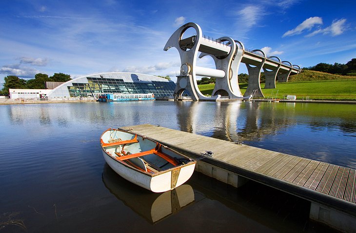
The Forth and Clyde Canal, built in 1790, winds its way through the Strathkelvin District to the north of Glasgow. The fully restored 35-mile waterway was an important link for seagoing vessels between the Firths of Clyde and Forth, joining the River Clyde at Bowling and the River Forth at Grangemouth. Today, you can take a very pleasant outing from Kirkintilloch aboard one of the vessels operated by the Forth and Clyde Canal Society.
Be sure to allow time to explore the spectacular Falkirk Wheel at the eastern end of the canal. Capable of carrying up to eight boats, this unique piece of modern engineering – part sculpture, part boatlift – connects the Forth and Clyde Canal with the Union Canal near the important industrial town of Falkirk.
Visitors can experience the hour-long journey aboard special boats and learn more about its operation at the visitor center. Behind-the-scenes tours of this engineering marvel are also available.
Address: Lime Road, Falkirk, Scotland
Official site: www.scottishcanals.co.uk/falkirk-wheel/
13. Summerlee Museum of Scottish Industrial Life
The Summerlee Museum of Scottish Industrial Life is based around the 20-acre site of 19th-century Summerlee Iron Works. Opened in 1836 and once one of the region's biggest employers, today this sightseeing trip is fun for kids as well as adults. Highlights include Scotland's only still-operating vintage tramway, a recreated mine, workers' cottages, and various Victorian steam engines. Guided tours of the abandoned mines are also available, and admission is free.
Address: Heritage Way, Coatbridge, Scotland
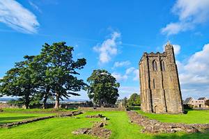
14. Paisley Abbey and the Thomas Coats Memorial Church
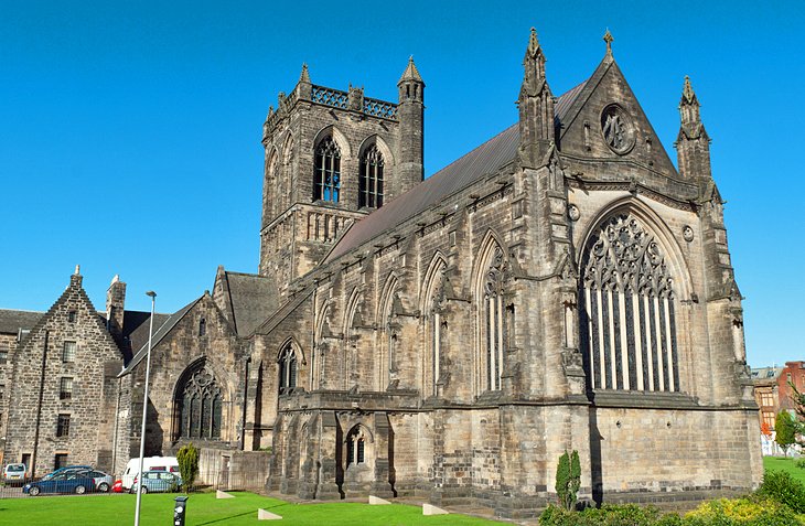
Some surviving parts of Paisley Abbey date from its original construction in 1163. Highlights of a visit include the choir stalls and a walk up 197 steps to the Tower.
Another Paisley landmark is the ornate Thomas Coats Memorial Church. Funded by one of Scotland's leading textile manufacturers and completed in 1894, its intricate stonework was the product of numerous apprentice stonemasons.
While in the area, pay a visit to Paisley Museum and Art Gallery, with its interesting displays relating to the development of the textile industry and the story of the distinctive "drop motif" on the world-famous Paisley pattern. Exhibits include the old looms on which the best-selling designs were produced, as well as original woven and embroidered shawls from Kashmir, the inspiration for the Scottish production.
Address: Abbey Close, Paisley, Renfrewshire, Scotland
Official site: www.paisleyabbey.org.uk
15. Gourock: Granny Kempock's Stone
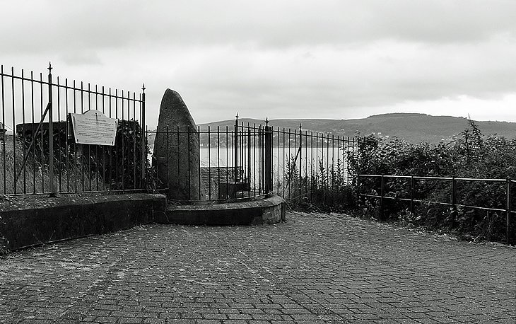
By the coast at Gourock, some 28 miles west of Glasgow, stands an interesting six-foot-tall slate monolith reputed to have been a meeting place for Druids. It's known as Granny Kempock's Stone. Fishermen would make small offerings in return for fine weather and good catches, and it's still customary for local newlyweds to circle the stone to bring good luck to their marriage.
The views across the Clyde Estuary toward the southwest Highlands make the journey to this seaside town worth the effort. The Gourock Highland Games are held here in May.
16. Greenock
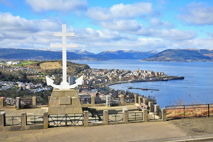
Greenock is another former industrial center near Glasgow that's worth a visit (in fact, you'll pass through it on your way to Gouruck, above). It's an easy hour-long train ride from Glasgow Central Station.
Greenock is famous as the birthplace of engineer James Watt, who made the Clyde navigable. the great engineer's life is celebrated here in the Watt Institution, a former library and now official archives dedicated to his life and work. Greenock is also famous for being the final resting place of "Highland Mary," immortalized by Robbie Burns.
Other highlights of a visit include McLean Museum & Art Gallery, and the interesting Scottish Fire and Rescue Service Museum and Heritage Centre with its collection of rare vehicles. If you've time and energy, make the 20-minute climb up Lyle Hill for its spectacular views over the Clyde and Greenock's wonderful skyline.
Map of Day Trips from Glasgow
More Related Articles on PlanetWare.com
Scotland Vacation Ideas: Home to Edinburgh Castle, Scotland's most visited tourist attraction, the romantic city of Edinburgh is a must-visit for any traveler to this beautiful country. The Highland city of Inverness is also worth including on your Scotland travel itinerary for its attractive riverside setting, and also serves as a great jumping-off point for another top Scottish destination: Loch Ness.