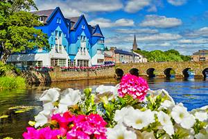
Tourist Attractions in Ireland
Author Meagan Drillinger has a Master's Degree in Irish Studies. She has studied there and visited many times over the years.
There's nothing quite like a visit to the Emerald Isle to cleanse your soul and reinvigorate your spirit. Home to some of the world's greenest, most breathtaking landscapes, Ireland brims with tourist attractions so appealing, you'll want to visit them all.
From the captivating Cliffs of Moher that will leave you gob-smacked to the bright lights of Dublin's Grafton Street to the hallowed halls of Trinity College, you'll find plenty of fun things to do in Ireland. The hard part will be choosing which fascinating attractions should top your must-see list.
Whether you're hoping to spend time pursuing Ireland's endless number of outdoor activities (we're talking horseback riding, waterfall hiking, golf, and sailing) or hope to study the works of some of the country's most famed artists in state museums and galleries, you won't be at a loss for intriguing ways to spend your time.
Discover all the best places to visit in this stunningly attractive country with our list of popular tourist attractions in Ireland.
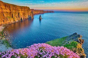
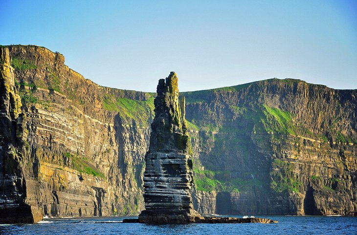
The Cliffs of Moher
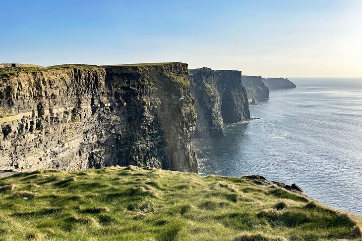
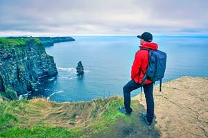
So many superlatives have been used to describe the magnificent Cliffs of Moher that it's hard to find the right words. Vertigo-inducing and awe-inspiring spring to mind, and they are indeed both of these things, as well as being utterly wild and ruggedly beautiful.
For those who've read up on the Emerald Isle prior to visiting, the cliffs will be familiar, starring as they do in countless postcards and guidebooks. Yet no image can ever do them justice. This is one of the top tourist attractions in Ireland for good reason.
About one and a half hours by car from Galway, in neighboring County Clare, the cliffs are visited by close to a million people from across the globe each year. It's one of the popular day trips from Dublin, but be prepared for a very long day, with a drive time of three to four hours each way.
The cliffs stretch for eight kilometers along the Atlantic and rise some 214 meters at their highest point. Take a walk along the Hag's Head trail to experience the raw power of nature at its most majestic.
An even more majestic experience at the cliffs is a boat trip from nearby Doolin Pier. These small-group tours offer a less crowded view of the cliffs, showcasing hidden caves and the large seabird population.
Grafton Street, Dublin
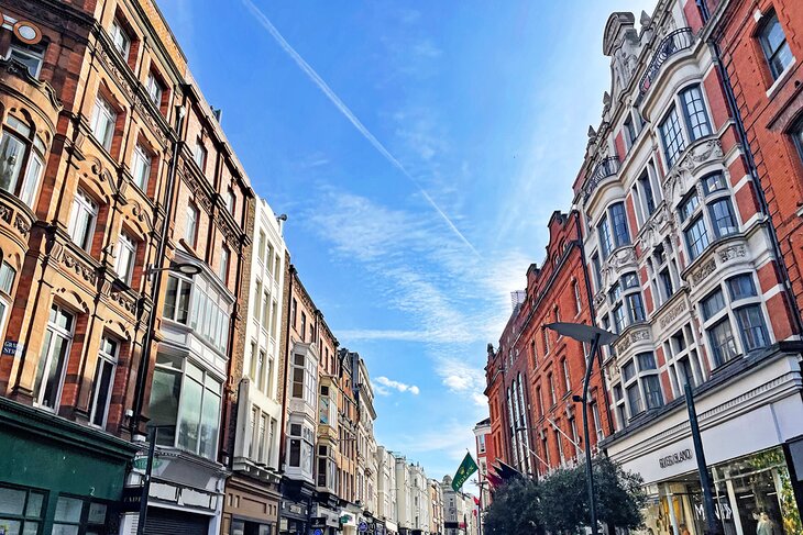
So much more than just a great place to shop in Dublin, Grafton Street, with its restored Victorian architecture, is alive with buskers, flower-sellers, and performance artists. You will also find countless places to stop off and simply watch the world meander by. Café culture has taken off in the capital, and on a sunny day, you'd be forgiven for thinking you were in Barcelona or Lisbon.
True, this is Dublin's shopping heartland, but there's no need to spend a fortune if visiting. You'll find friendly, chatty service no matter where you go, and be entertained from the bottom of the street to St. Stephen's Green at the top. Grab a coffee or, in the mornings, a legendary Irish breakfast at Bewley's Grafton Street Café. Take time as well to duck down the numerous alleyways and streets to see what you can discover.
- Read More: Tourist Attractions in Dublin
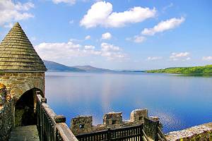
Killarney National Park and Muckross House & Gardens
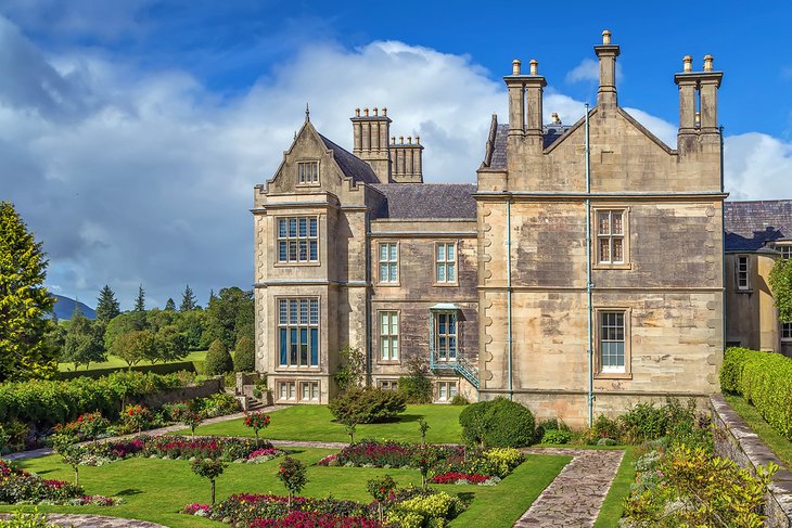
If visiting the Kerry region, the 19th-century Muckross House, Gardens, and Traditional Farms, set in spectacular Killarney National Park, should be top of your must-see list. There are many reasons this is deemed one of the best tourist attractions in Ireland; you'll need to visit to discover them all.
Standing close to the shores of Muckross Lake, one of three Killarney lakes famed worldwide for their splendor and beauty, this former mansion oozes the grandeur and gentility of bygone days. When exploring, bear in mind that Queen Victoria once visited here. In those days, a royal visit was no small affair; extensive renovations and re-landscaping took place in preparation, and no detail was left to chance.
The house and gardens are a real treat, and there are Jaunting Cars (Killarney's famous horse & traps) to take you around the grounds in style. The attraction's old farmsteads are also well worth taking in for a taste of how ordinary folk once lived.
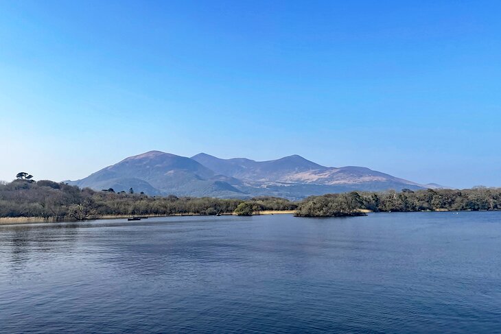
The Killarney National Park & Lakes region is filled with beautiful scenery, and any route through it will reveal view after view of its lakes and mountains. A highlight in the western part of Killarney National Park is the 11-kilometer drive over the scenic Gap of Dunloe, a narrow and rocky mountain pass carved by glaciers at the close of the Ice Age. The gap separates Purple Mount and its foothills from Macgillycuddy's Reeks.
If you enjoy hiking, the area has many great trails. One of the most famous, which showcases the lakes and passes a waterfall, is the Torc Mountain walk. It's about a seven to eight kilometer-long walk and takes three to four hours to complete.
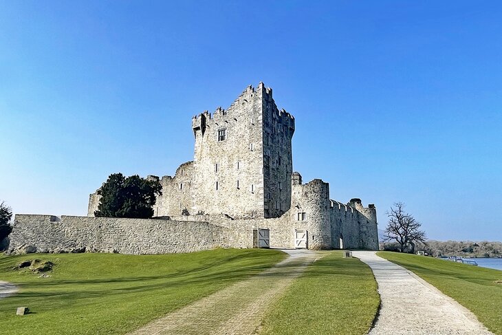
Another highlight of this national heritage site is Ross Castle. Winding lanes and cycling paths are among the best ways to see the park. Boat trips on the lake are also available and give a unique perspective of the castle and the surrounding islands.
Address: Killarney National Park, Muckross, Killarney, Co. Kerry
- Read More: Tourist Attractions in Killarney
The Book of Kells and Trinity College, Dublin
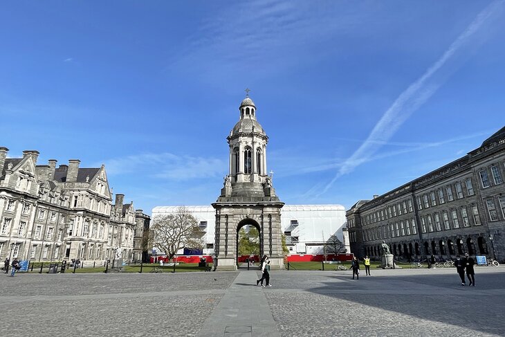
Ireland's oldest university, Trinity College in Dublin, is one of the country's ancient treasures. Founded in 1592 by Queen Elizabeth I, Trinity is a world within a world.
Once you enter the gates and cross the cobblestones, it's as if the modern, thriving city outside simply melts away. A stroll in and around the grounds is a journey through the ages and into the hushed world of scholarly pursuit. Many shop and office workers take their lunchtime sandwiches here during the summer months simply to escape the hustle and bustle outside.
The college is also famed for its priceless treasures. These include the awe-inspiring Book of Kells (on permanent exhibition) and the mind-boggling Long Room (the inspiration for the library in the first Harry Potter movie).
Address: Trinity College, College Green, Dublin 2
- Read More: Tourist Attractions in Dublin
Kilmainham Gaol, Dublin
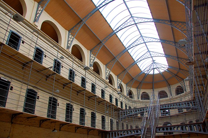
Featured in many a rebel song and occupying a notoriously dark place in Irish history, Kilmainham Gaol should be high on the list of Dublin's best places to visit for those with any interest in Ireland's troubled past.
It was here that the leaders of the 1916 Uprising were brought and, after being convicted of High Treason, executed in the prison yard. The only one spared was future Irish President Eamon De Valera, who, by virtue of his American citizenship, didn't suffer the same grisly fate.
Dating from 1796, the prison was a dank, vile institution that housed those guilty of such misdemeanors as being unable to pay their train fares and, during the famine, the destitute and hungry. In Irish eyes, Kilmainham became an irrevocable symbol of oppression and persecution.
A visit here will open your eyes and will remain with you indelibly. The yard mentioned earlier is particularly spine-chilling. In short, this is one of Ireland's absolute must-sees.
Address: Inchicore Road, Dublin 8
The Ring of Kerry
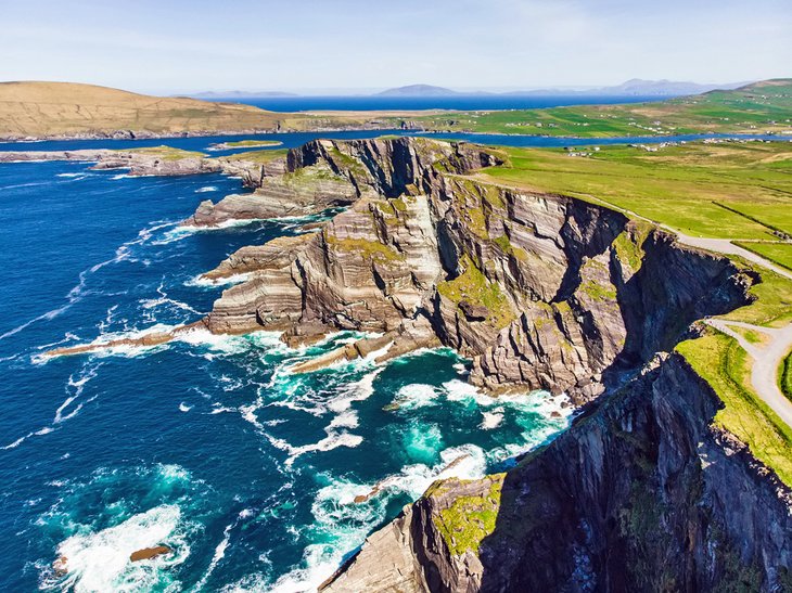
If in Kerry, take the time to explore what is arguably Ireland's most scenic route, the Ring of Kerry (Iveragh Peninsula). While you can start anywhere along this spectacular 111-mile-long tourist route, most people tend to set out from either Kenmare or Killarney ending, naturally enough, back in the same spot.
Consider driving the Ring of Kerry counter-clockwise to avoid congestion and facilitate easier stops at viewpoints, as most tour buses travel in the opposite direction.
The entire journey, non-stop, could take under three hours, but that's unlikely to happen. En route, there's a feast of jaw-dropping Atlantic Ocean views, stunning islands to visit, a possible detour to Valentina Island, wild sweeping mountains, and many picturesque villages.
This area of astounding natural beauty boasts a range of outdoor pursuits including golf, water sports on pristine beaches, cycling, walking, horse-riding, and terrific freshwater fishing and deep-sea angling. For history enthusiasts, there are Ogham Stones, Iron Age forts, and ancient monasteries, all set against a canvas of striking landscapes.
To truly step back in time, take one of the boat trips to the Skellig Islands and the UNESCO World Heritage site of Skellig Michael. This site is renowned for its ancient monastic settlement and, more recently, its appearance in the Star Wars franchise as Skywalker's Island Sanctuary on the planet Ahch-To.
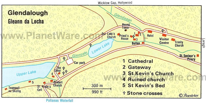
Glendalough, Co. Wicklow
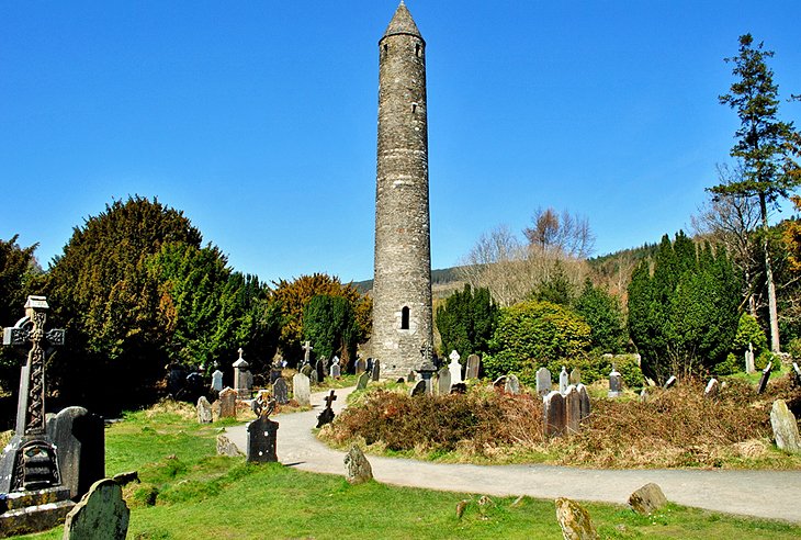
Magical and mysterious, Glendalough is home to one of the most important monastic sites in Ireland. The settlement was established by St. Kevin during the 6th century and eventually evolved into what's known as the Monastic City.
Visitors have flocked to the valley of the two lakes for thousands of years to absorb its rich history, magnificent scenery, plentiful wildlife, and fascinating archaeological finds.
The monastic site with its incredibly preserved round tower is a joy to explore, and the surrounding woodlands and lakes are perfect for rambling through at your leisure or stopping off for a picnic. There are marked nature trails to follow and a Visitor Centre for all the information you'll need for a day out like no other.
Address: Glendalough, Co. Wicklow
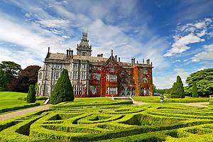
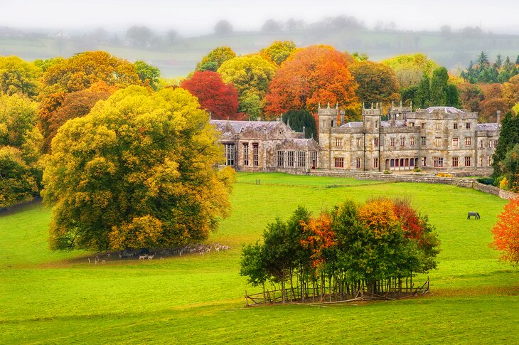
Powerscourt House and Gardens, Co. Wicklow
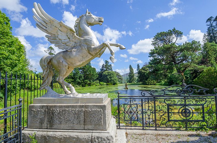
Superb views, serene lakeside walks, engaging history, and the stunning backdrop of Sugarloaf Mountain are just some of the treats in store when visiting the magnificent Powerscourt House and Gardens, just 20 kilometers from Dublin.
Now owned by the Slazenger family, the house is set on 47 manicured acres. Take time to stroll through the Rose and Kitchen Gardens and explore the beautiful Italian Gardens. There are more than 200 varieties of trees, shrubs, and flowers, and particularly moving is a section where much-loved family pets were buried complete with headstones and inscriptions.
The gardens were laid out over a period of 150 years and were designed to create an estate that blends harmoniously with the surroundings. On-site, in the former Palladian home, are craft and design shops and an excellent café/restaurant. Truly one of the most majestic attractions in Ireland, this is also one of the top day trips from Dublin.
Combine a trip here with nearby Powerscourt Waterfall, Ireland's highest falls, just a 10-minute drive away.
Address: Enniskerry, Co. Wicklow
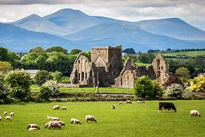
The Rock of Cashel
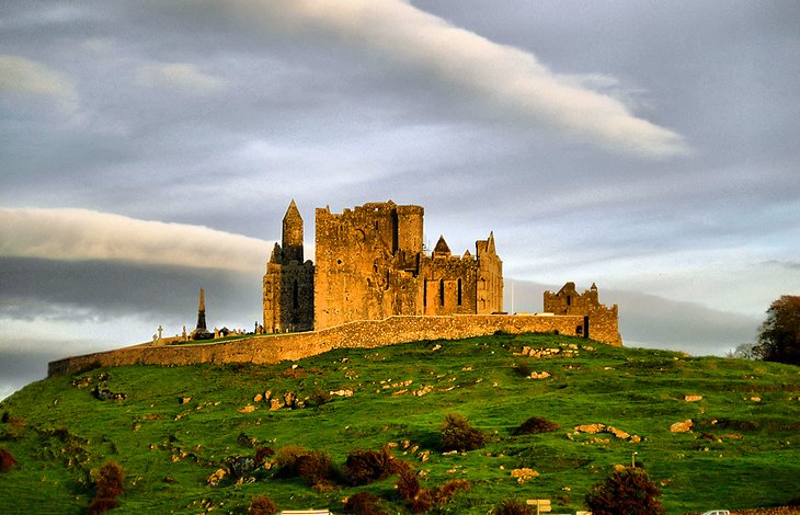
Ireland's most visited heritage site, the Rock of Cashel stars in countless images of the Emerald Isle. Queen Elizabeth II of Great Britain even visited by helicopter during her 2011 official tour of the country. Perched upon a limestone rock formation in the Golden Vale, this magnificent group of medieval buildings includes the High Cross and Romanesque Chapel, the 12th-century round tower, a 15th-century castle, and a 13th-century Gothic cathedral.
The restored Hall of the Vicars Choral is also among the structures. Tourist attractions include an audio-visual show and exhibitions. It's also said that this was once the seat of the High Kings of Munster prior to the Norman invasions.
Consider visiting in the late afternoon after the tour buses and crowds have gone; you'll get the best light for photography and won't have to deal with the crowds. For more history and unique photography opportunities, add a quick stop at Hore Abbey, a ruined Cistercian monastery nearby.
Address: Cashel, Co. Tipperary
National Museum of Ireland, Dublin, and County Mayo
It's easy to spend an entire day at the National Museum of Ireland, which is technically a collection of museums. Admission is free to all buildings. Inside, you'll find displays highlighting the country's "natural history" on Merrion Street in Dublin 2, "decorative arts & history" in Dublin's Collins Barracks, "country life" in Mayo, and the stunning "archeology" museum on Kildare Street in Dublin 2.
Depending on which building you visit, you can expect to find interesting exhibits on everything from Irish Antiquities to Irish folklife to Celtic art. The National Museum of Ireland—Archaeology is home to over two million historic artifacts, and contains fascinating finds, including metalwork that dates to the Celtic Iron Age. This is also the museum where you can view the world-famous "bog bodies," dating back to the Iron Age and Roman periods.
The National Museum of Ireland—Country Life, which lies in Turlough Park, Castlebar, is housed in a unique building that seamlessly blends Victorian and contemporary architecture. Inside, you'll find photographs, films, ancient furniture, and permanent exhibits on everything from Irish hearth and home to life in the community to various jobs held on both land and water.
The National Museum of Ireland—Decorative Arts & History is housed in an iconic military barracks and contains historic treasures such as ceramics, glassware, clothes, jewelry, and coins.
The National Museum of Ireland—Natural History is home to over 10,000 exhibits featuring the country's most beloved wildlife, as well as interesting creatures from across the globe.
Blarney Castle and the Blarney Stone
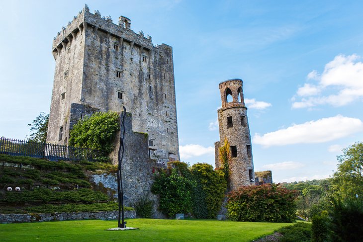
Possibly Ireland's best-known attraction and one of its must-see-castles, the Blarney Stone sits high on a tower of Blarney Castle, not far from Cork. Reputed to endow the famed Irish eloquence to those who dare hang their head over the parapets to kiss it, the stone is not the only reason for visiting Blarney Castle.
Blarney Castle was built more than 600 years ago by Irish chieftain Cormac McCarthy, and you can tour the massive stone building from its towers to its dungeons. Extensive gardens surround it, filled with stone features and secret corners. Blarney Woollen Mills is known for its sweaters and other knitwear and has a shop selling crystal, porcelain, and other Irish gifts.
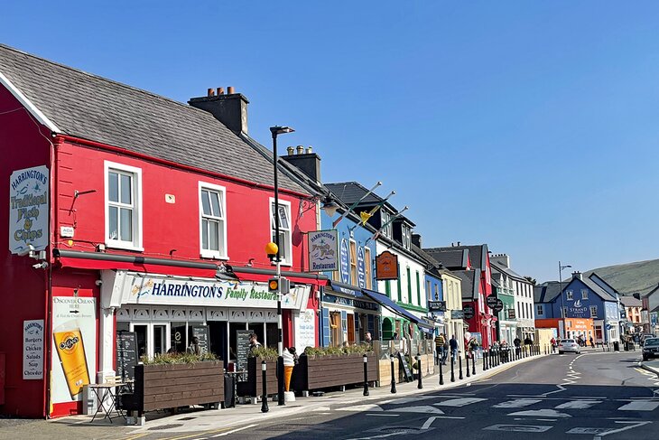
Kinsale, Co. Cork
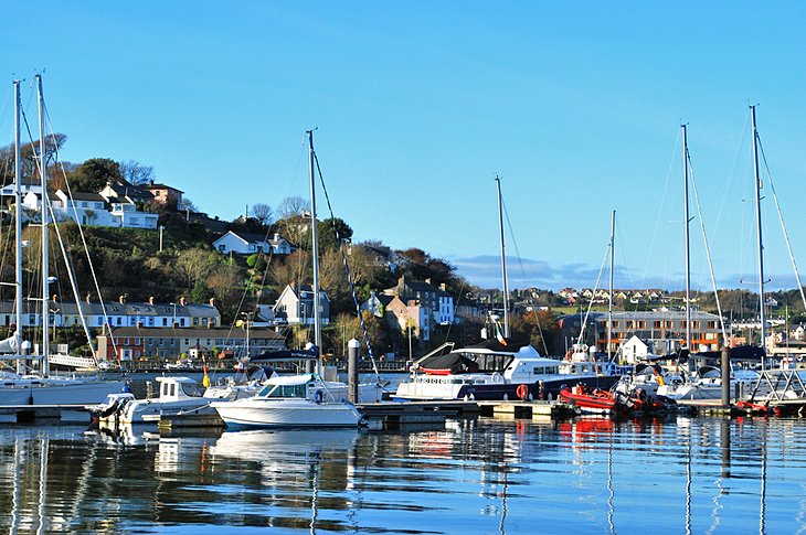
Soaked in history and in a scenic coastal setting at the gateway to West Cork, Kinsale has been attracting large numbers of visitors for decades. With its narrow streets and colorful buildings, it's one of the best small towns in Ireland for tourists.
The town has a decidedly Spanish feel, particularly in summer. This is hardly surprising bearing in mind that in 1601, three years after the defeat of the Spanish Armada, the Spanish sent a military force to Ireland, most of whom disembarked at Kinsale. This led to the English laying siege to the town and ultimately the defeat of Spanish and Irish forces by superior English military might.
Kinsale is now a magnet for those who love sailing, walking, fishing, marvelous scenery, and great food. The town is packed with restaurants of all sorts, and the seafood on offer is excellent. Don't miss the annual Gourmet Festival and the impressive old forts: Charles Fort and James Fort.
The Dingle Peninsula and the Wild Atlantic Way
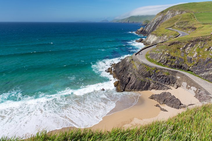
Part of The Wild Atlantic Way, a 1700-mile marked route around Ireland's west and adjacent coasts, the Dingle Peninsula combines wild beauty and history.
To experience the natural highlights of the region, drive the 38-kilometre-long Slea Head Drive, a renowned scenic loop that takes about half a day, depending on the number of stops.
The area also offers a glimpse of traditional Irish culture and language as the region is designated as a Gaeltacht, where the Irish language and culture are protected by government subsidies. You'll hear Gaelic spoken and sung, and read it on signs, although everyone also speaks English.
Ending at Dunmore Head, the Irish mainland's westernmost point, the peninsula is bordered by some of Ireland's best beaches and ragged cliffs. Stone huts that scatter its open landscapes were built by monks in the early Middle Ages, and you'll find more stone monuments that date to the Bronze Age.
Torc Waterfall, Killarney National Park
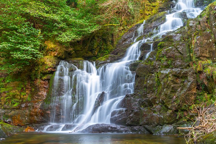
It's easy to see why the Torc Waterfall is one of the best places to visit in Ireland. Situated in the heart of Killarney National Park, this 20-meter-tall cascade is one of the top attractions in the Ring of Kerry. The relaxing sound of rushing water can be heard from the nearby car park, which lies a mere 200 meters away, an easy walk for those who find hiking difficult.
If you're hoping for a longer trek, continue on the Kerry Way, a 200-kilometer well-sign-posted walking trail that loops its way around the stunning Iveragh Peninsula on its way to and from nearby Killarney.
St. Stephen's Green, Dublin
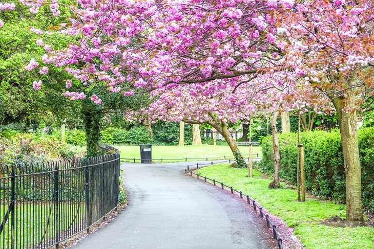
Beloved by Dubliners and with a colorful history, tranquil St. Stephen's Green is a great place to wind down, enjoy a picnic, or feed the ducks. Incidentally, during the 1916 Uprising, special dispensation was given on both sides to the park keepers. Hostilities ceased daily so that the ducks could be properly fed. It could only happen in Dublin.
Nowadays "The Green," as it's known locally, boasts beautifully maintained gardens, the ubiquitous Duck Pond, a picturesque bridge, recreation grounds, mature trees to rest beneath, and a playground.
Around the perimeter are many of Dublin's premier Georgian buildings as well as the iconic Shelbourne Hotel, founded in 1824, where afternoon tea in the Lord Mayor's Lounge is considered by many to be a real treat.
- Read More: Tourist Attractions in Dublin
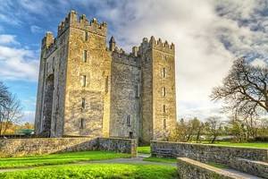
Bunratty Castle & Folk Park
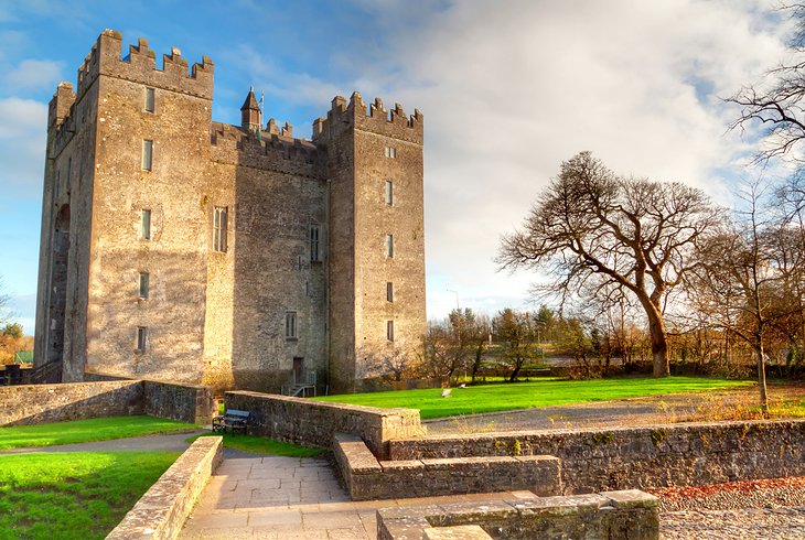
A visit to the Shannon region wouldn't be complete without coming here. Dating from 1425, the castle is the best-preserved medieval fortress in Ireland and was lovingly restored in the 1950s. Containing a fine array of 15th- and 16th-century furnishings and tapestries, the castle will transport you back to ancient medieval times.
The castle boasts a living history aspect, featuring costumed characters who demonstrate traditional crafts and daily life.
The themed banquets in the evenings are great fun, although certain guests who misbehave run the risk of being sent to the dungeons below. The impressive Folk Park brings the Ireland of a century ago vividly to life. Featuring more than 30 buildings in a village and rural setting, the folk park has village shops, farmhouses, and streets to explore. It's all great fun for families and kids.
National Gallery of Ireland, Dublin
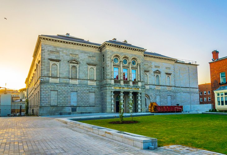
Founded in 1854 by an Act of Parliament, the National Gallery of Ireland is a beloved institution situated in Dublin's tree-lined Merrion Square. This grand gallery opened to the public in 1864 but recently underwent an extensive renovation, creating even more impressively airy and bright spaces to house its vast collection of artworks. Don't worry, the impressive, 19th-century architecture was well preserved.
In addition to the picturesque structure, inside you'll find a collection of the country's most famous art, as well the national collection of paintings by the European Old Masters. Its convenient location in Dublin's city center makes it easy to spend the rest of your day shopping and dining in the city's best establishments.
Even better than the impressive works found in this gallery is the price: admission is free. With so many intriguing pieces to examine, we'd suggest setting aside a few hours to explore it fully.
Address: Merrion Square West, Dublin 2
The English Market, Cork
No visit to Cork would be complete without dropping by the English Market. That said, it's a tad ironic that what is arguably one of Cork city's best attractions should contain the word "English" — Cork folk usually see themselves as far more ideologically and culturally removed from neighboring Britain than their Dublin counterparts.
Having said that, they hold a special place in their hearts for this quirky covered market, which stocks the best of local produce, including the freshest seafood, artisan bread, and excellent cheeses.
A market has existed on the site since the late 1700s, although the distinctive entrance on Princes Street dates from 1862. Recent worldwide fame came when Queen Elizabeth II dropped by on her first-ever state visit to the Republic of Ireland in 2011. Iconic images of her sharing a joke with Fishmonger Pat O'Connell were beamed across the globe.
For those who wish to linger a while, there's coffee to go and the cozy Farmgate Restaurant upstairs.
Address: Princes Street, Cork (off St. Patrick's Street & Grand Parade)
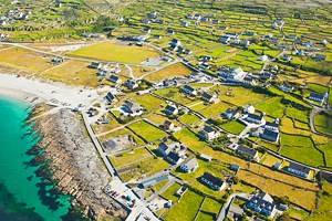
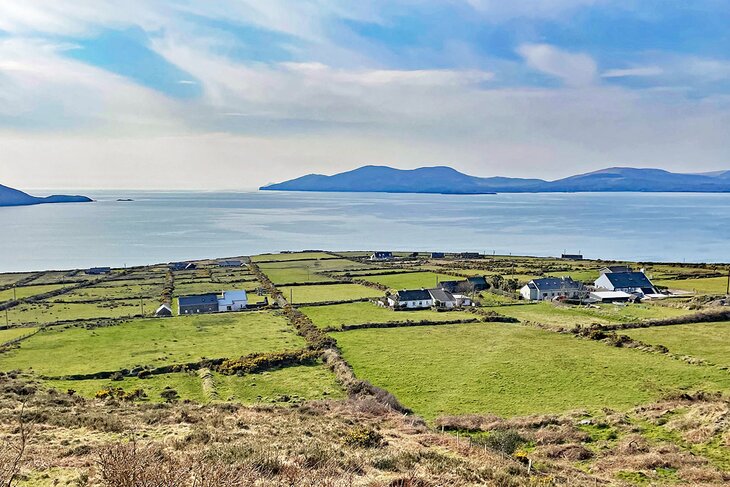
The Aran Islands
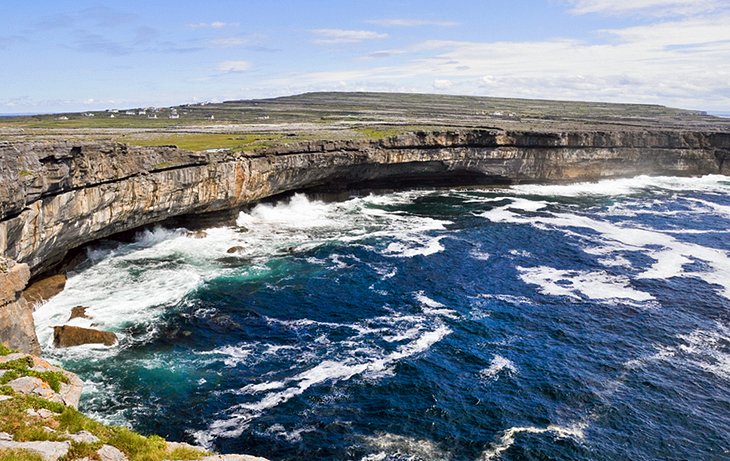
Originally brought to world attention in 1934 by the fictionalized documentary Man of Aran, these islands have been entrancing visitors ever since. This is a taste of Ireland as it once was. Gaelic is the first language; there are a mere 1,200 inhabitants; and once ashore, you'll feel as if you're in a time warp.
There are three islands, the largest being Inishmore, then Inishmaan, and the smallest is Inisheer.
Wild, windswept, rugged, and utterly unique, the islands offer a visitor experience quite like no other. Once experienced, the great stone fort of Dun Aonghasa and the towering cliffs of Aran will never be forgotten. The local culture is quite different from that of the mainland, the archaeological heritage cannot be found elsewhere and the rich scenery is simply breathtaking.
Kilkenny Castle, Kilkenny
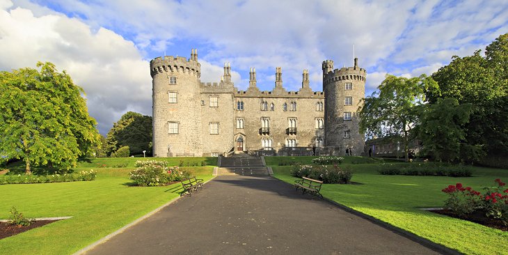
Despite housing many different owners and undergoing multiple stints of rebuilding, Kilkenny Castle has stood strong for over 800 years. While it looks Victorian from the outside, the castle's roots date to the 13th century. This is when it was built by William Marshal, who created this masterpiece to serve as a "symbol of Norman Control."
Today, the castle is open to visitors wishing to traipse through the 50 acres of lush grounds, which include a stunning, terraced rose garden; towering, ancient trees; and a sparkling, man-made lake. It is one of the most beloved tourist attractions in Ireland.
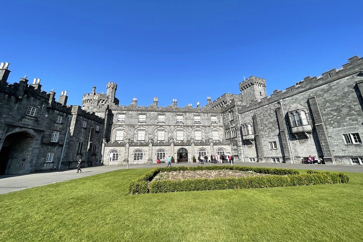
The grand house is open to explore, and it's here you'll find an ornate entrance hall, eerie undercroft, and captivating tapestry room, as well as period rooms like the nursery.
The 19th-century pitched roof picture gallery is particularly impressive for those who enjoy admiring creative works in a captivating setting.
Address: The Parade, Kilkenny
Read More: Attractions & Things to Do in Kilkenny
The Little Museum of Dublin
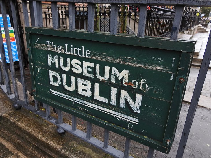
A recent addition to the capital's museums, The Little Museum should be top on the list for anybody wishing to grasp Dublin's recent history. The museum grew organically from a "meet and greet" service for visitors, and quickly became what we see today. As well as informative, personally guided tours, new initiatives include Dublin by Land & Sea and The Green Mile Walking Tour.
On permanent exhibition are such items as the lectern used by John F. Kennedy during his 1963 visit to Ireland, and a U2 exhibition with mementos donated by band members themselves. This is a joyful museum that celebrates Dublin with all its quirkiness and humor.
Address: 15 St. Stephen's Green, Dublin 2
Experience Glasnevin Cemetery
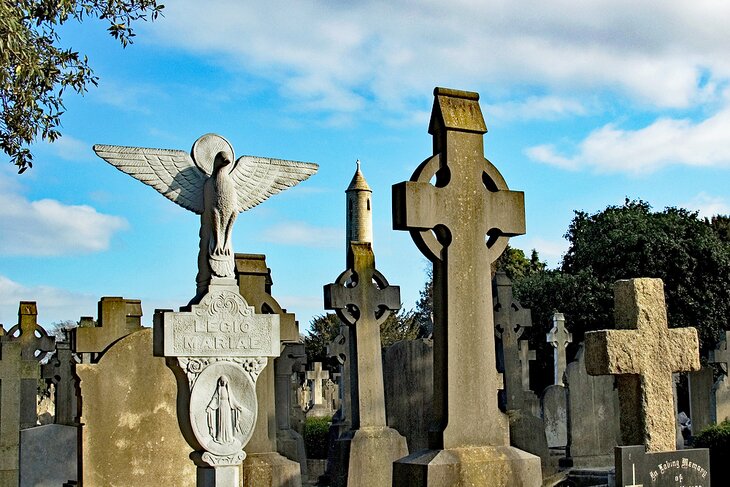
Perhaps one of the best ways to learn about the history of Ireland is to wander among its most notable figures. The Glasnevin Cemetery, Ireland's National Cemetery, is a place practically packed with history, as most of the country's pivotal players are buried here.
Glasnevin is both the country's largest cemetery as well as the world's first cemetery museum. It opened in 1832 and is the final resting place for more than 1.5 million people. Among the celebrated figures buried here are Daniel O'Connell, Michael Collins, Charles Stewart Parnell, and Eamon de Valera, all of whom played an integral role in the shaping of modern-day Ireland. The cemetery also has 800,000 victims of the Great Famine from the 1840s.
Prior to the opening of the ceremony, Catholics in Ireland were limited in how they could bury and honor their dead, thanks to 18th-century Penal Laws put in place by England. The cemetery opened as a place where both Irish Catholics as well as Protestants could bury their dead without restriction.
The cemetery museum has exhibits that include an immersive display that teaches visitors about burial practices and customs in Ireland. The cemetery itself is designed beautifully, with a traditional Victorian garden, monuments, and sprawling lawns. Today, the entire cemetery takes up 124 acres, and guided tours are available.
Address: Finglas Road, Glasnevin, Dublin, D11 XA32, Ireland
Map of Tourist Attractions in Ireland
Best Time to Visit Ireland
While the shoulder seasons in the spring and fall are great times to visit for the smaller crowds, each season brings with it unique reasons to go.
Summer has some of the best weather, and winter has the best rates for lodging and transportation. It is important to consider the factors that matter to you most and start your planning from there, since some things in your itinerary will be dependent on the time of year that you go.
Spring: The spring months are some of the best times to visit Ireland. You can plan on comfortable weather and not as many crowds as the summer season. The rates for airfare and hotels will be lower, and you can find incredible deals on bed and breakfast accommodation. B&B Ireland is a network of B&Bs throughout the country that have been inspected for quality, and the network extends throughout the country.
The flowers in Ireland are blooming in April and May, so the many gardens and landscaping at the castles will be stunning for a spring visit. Crowds are smaller in the spring, which is nice, especially at attractions like castles that have narrow stone stairwells and in the small villages where shopping quarters and sidewalks are small.
The only caveat with spring is the occasional rain shower. They generally come and go and do not last long, so a glimpse of sunshine is always around the corner. Pack for the potential of rain, and you will be fine.
Summer: If your Ireland priority is to travel during the months with the best weather, then summer is when to go. June, July, and August are the sunniest months in Ireland and they are also the busiest with tourists.
The nice thing about Ireland's consistent weather is that even in the middle of summer, the temperatures never get overly hot. This makes it nice for spending full days outside, especially since you will need to plan a little extra time at attractions due to the many tourists.
The long days of summer allow for more time to sightsee attractions, and these are the months when festivals are in full swing. Since the summer months see the most tourists, that means rates at hotels and airfares are at their highest.
If you do plan to travel to Ireland in the summer, you should book your accommodations far in advance, as availability will become limited the closer you get to your travel dates.
Fall: The months of September and October are great times to go to Ireland when the brisk fall air and leaves changing colors add to the experience and natural beauty of the island. The summer tourists are gone in the fall, and you can enjoy no lines at the popular attractions. Since it is the shoulder season, you can expect the same unpredictable weather as the rest of the year, with a slightly higher risk for occasional rain.
Light rain in the fall months will not deter your ability to take ferries to nearby islands or other experiences, you just have to plan for the possibility. Even the open-air, double-decker, hop-on, hop-off buses in Dublin keep operating in the rain.
You will find many farmers markets and outdoor craft festivals throughout Ireland in the fall, and you can enjoy the break on rates at hotels and for airfare. Be advised that some smaller establishments, businesses, and B&Bs close up for the season after October, so check into that before booking airline tickets.
Winter: If a cozy Ireland vacation sounds appealing, then traveling in the winter months between November and February can net you some huge discounts, especially if you plan to base out of main cities like Dublin or Cork.
More Related Articles on PlanetWare.com

Things to Do in Ireland and When to Visit: Some people come here for a quick weekend break, while others come on longer trips to explore the castles, cities, and small towns. A few people come here to fish. Anglers will want to be sure to see our article on the best fishing destinations in Ireland. One thing to consider if you are planning activities or even sightseeing is the time of year you want to travel.