25 Top-Rated Attractions & Places to Visit in Oregon
Oregon is a state of adventurous landscapes. From the coast to the mountains and the Oregon high desert, vacations to the state traverse all types of terrain. The multitude of places to visit and things to do in Oregon can make planning a getaway overwhelming until you have a complete picture of everything Oregon offers.
A few beautiful places in Oregon include an ancient lake created by a volcanic eruption, a luscious gorge streaming with waterfalls, and several impressive sea stacks jutting out of the ocean. These scenic attractions are spread throughout the state, leading to memorable road trips and excursions.
In addition to its natural beauty, Oregon is equally known for its urban charms. The state's largest city, Portland, has an international reputation for drawing tourists with an offbeat and welcoming culture. The top things to do in Portland range from visiting rose gardens and art museums to browsing an immense bookshop. And this cultural capital is only one of many of the best cities in Oregon.
Plan your summer or winter trip to Oregon with our list of the top attractions and places to visit.
- 1. Crater Lake National Park
- 2. Columbia River Gorge National Scenic Area
- 3. Cannon Beach
- 4. Washington Park, Portland
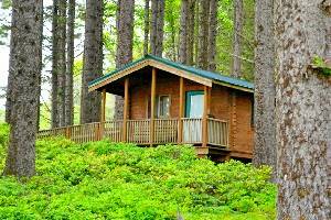
- 5. Mount Hood National Forest
- 6. Bend
- 7. Astoria
- 8. Hood River
- 9. Samuel H. Boardman State Scenic Corridor, Brookings
- 10. Smith Rock State Park, Terrebonne
- 11. Oregon Shakespeare Festival, Ashland
- 12. Newport
- 13. Sisters
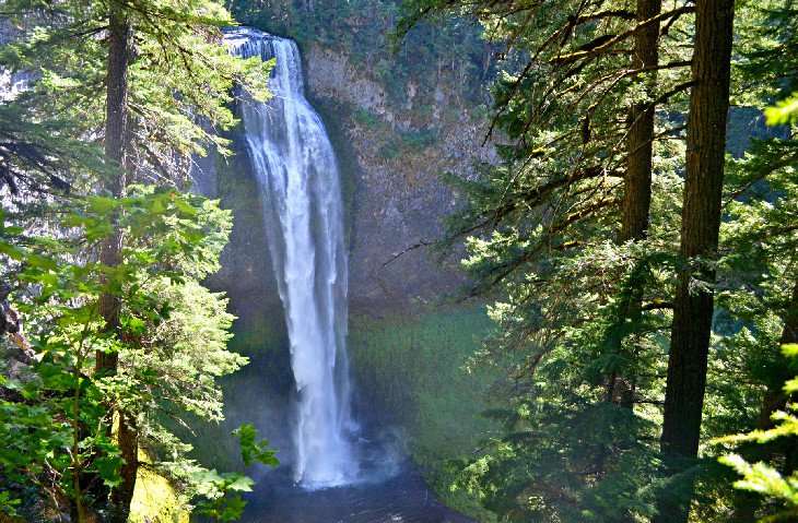
- 14. Silver Falls State Park, Sublimity
- 15. Depoe Bay
- 16. Newberry National Volcanic Monument
- 17. Klamath Falls
- 18. Oregon Dunes National Recreation Area
- 19. Hells Canyon National Recreation Area
- 20. Oregon Coast Trail
- 21. Willamette National Forest
- 22. Willamette Heritage Center at The Mill, Salem
- 23. Jordan Schnitzer Museum of Art, Eugene
- 24. Oregon Caves National Monument and Preserve
- 25. Medford
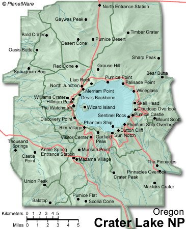
1. Crater Lake National Park
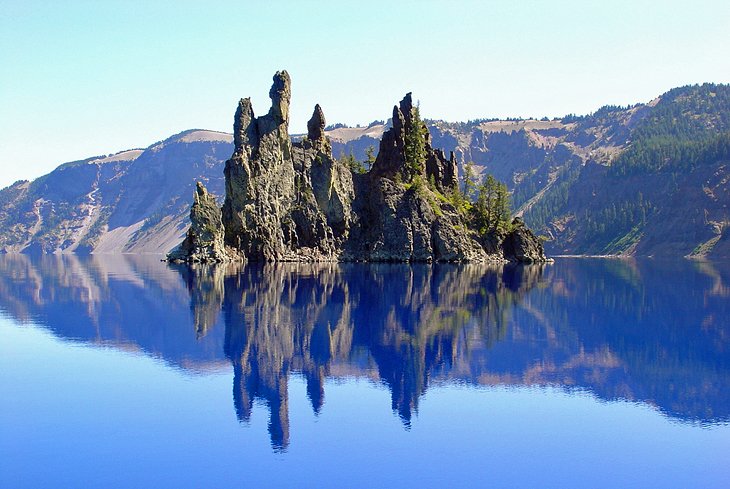
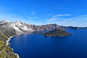
Crater Lake National Park lies in the Cascade Mountains of southwestern Oregon. Its landscape is like nowhere else. It's not actually a crater but rather an ancient caldera of an extinct volcano, Mount Mazama, which erupted over 7,000 years ago. Today, lava cliffs rise 2,000 feet around the sky-blue, seemingly bottomless lake.
The easiest way to see and visit Crater Lake is along Rim Drive, circumnavigating the entire lake. The route begins at Rim Village, home to the Crater Lake Lodge and Rim Village Visitor Center. Rim Drive is only drivable in the warm weather months (typically mid-July to Mid-October). Snowshoers and cross-country skiers utilize the unplowed road for winter travel throughout winter.
Crater Lake National Park is home to some of Oregon's best hiking trails. Stunning trails like Watchman Peak give great views of the caldera, while more moderate options stem from Rim Village via paved sidewalks. And extended hiking and backpacking opportunities, including the country-spanning Pacific Crest Trail, present themselves away from the rim.
To access the water in the summer, head to Cleetwood Cove, where cruises depart for Wizard Island. Camping is also available at two developed campgrounds, with most sites found at the Mazama Campground, located in the Mazama Village.
Southern Oregon has a lot more to explore outside the national park. Crater Lake is surrounded by wild places like Umpqua National Forest and Rogue River-Siskiyou National Forest, featuring hundreds of more miles of hiking trails to explore. And Crater Lake is at the northern end of the spectacular 500-mile, state-spanning Volcanic Legacy Scenic Byway.
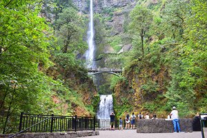
2. Columbia River Gorge National Scenic Area
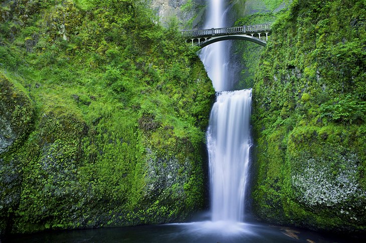
The Columbia River Gorge National Scenic Area follows the course of the Columbia River as it cuts through the Cascade Range. This stunning river gorge is the boundary line between Oregon and Washington. It falls within a thirty-minute drive from Portland and is best known for its spectacular views and numerous waterfalls.
Traveling along the Historic Columbia River Highway through the gorge offers a slower pace than the adjacent Interstate 84. This historic corridor has several roadside attractions and is a popular route to explore via bicycle.
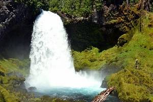
The tallest waterfall in the state, Multnomah Falls, is perhaps the most iconic display of gravity in the Columbia River Gorge. Alongside a dazzling two-tier waterfall, the area around Multnomah offers a range of hiking and biking trails, plus camping facilities. It's also home to the historic Multnomah Falls Lodge, built in 1925, and is still a popular place to dine or stay the night.
Multnomah Falls is one of the most popular day trips from Portland, but not even close to the only waterfall to check out in the gorge. One of the many other great destinations to aim for is Punchbowl Falls on Eagle Creek. This iconic waterfall doesn't drop anywhere close to the same distance as Multnomah Falls, but it arguably leaves an even better impression.
Author's Tip: New Time Use Permits have been in place for the past few years, requiring visitors to reserve parking spots during peak visiting season (May 26th – September 4th). You can bypass the need for a permit with different transportation means. Check out all the options with the From Portland to Multnomah Falls: 5 Best Ways to Get There guide.
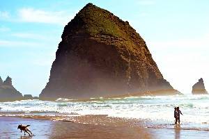
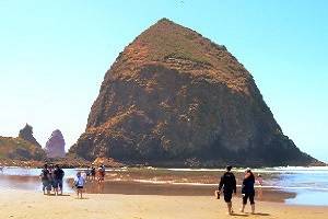
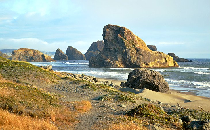
3. Cannon Beach
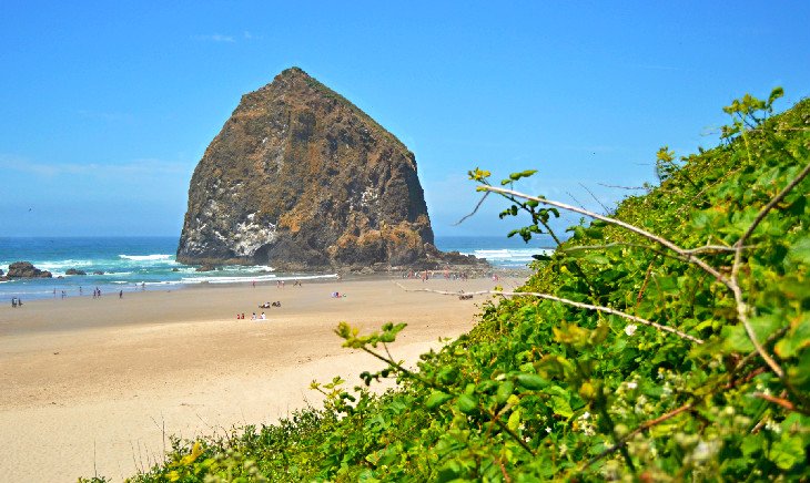
Cannon Beach is a popular tourist destination on the northern Oregon coast with a vast stretch of sand and spectacular views of jagged coastal rocks. Haystack Rock is the largest of these sea stacks and is a constant presence during any visit to this coastal community.
Alongside spectacular ocean scenery, Cannon Beach also delivers cultural appeal with restaurants, boutique shops, and great hotels. This combination of culture, community, and ocean access earns Cannon Beach its reputation as one of the best small towns on the Oregon Coast,
To the north of Cannon Beach, the enchanting Ecola State Park and Tillamook Head encompass historic and scenic landscapes to explore, including a trail that follows the path of Lewis and Clark. The charming city of Seaside is on the other end of Ecola State Park, offering more days of family-friendly travel along the coast.
4. Washington Park, Portland
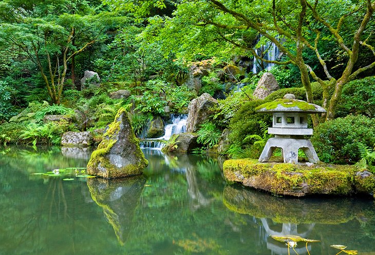
Portland offers a bevy of delightful parks and gardens, but none has quite the density of attractions as Washington Park. Within park grounds, the famed International Rose Test Garden is located near the impressive Portland Japanese Garden. Both display exceptional horticultural expertise and are favorites with green thumbs.
Washington Park is also home to the Oregon Zoo, Hoyt Arboretum, World Forestry Center Discovery Museum, and a popular Rose Garden Children's Playground. And even without these attractions, Pacific Northwest splendor imbues the entire park with a dense landscape of foliage and nature.
The park is also next to the expansive Forest Park, encompassing approximately 1,300 acres, and home to some of the best hiking trails in the Portland area. Plan to spend the whole day exploring this urban respite in the middle of the city.
Author's Tip: Parking is scarce in parts of Washington Park, particularly nearest the International Rose Test Garden and Portland Japanese Garden. A free Washington Park shuttle operates within the park daily between April and September, and several public transit options bridge the gap between downtown and the park.
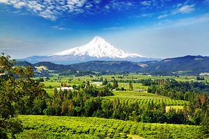
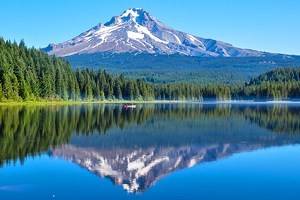
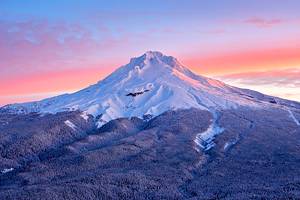
5. Mount Hood National Forest
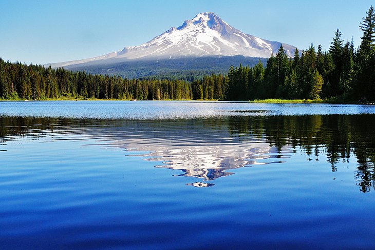
Mount Hood is the highest mountain in Oregon, with a peak rising to 11,239 feet. This enormity makes the mountain an unmistakable landmark of the state, seen from miles in every direction. On clear days, it provides a brilliant backdrop for the city of Portland to the east.
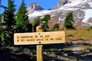
Mount Hood National Forest encompasses the entire mountain and much of its flanks. This public space offers all types of adventures. On the mountain slopes are downhill offerings at Mount Hood Skibowl, picturesque hiking paths like the Timberline Trail, and scenic viewpoints accessible via the Mount Hood Scenic Loop. The nation-spanning Pacific Crest Trail also crosses the southwest flank of the mountain.
The historic town of Government Camp and the nearby Timberline Lodge are big attractions in this mountain landscape. The reflective Trillium Lake offers a postcard setting and a great mountain view. Mount Hood National Forest fans out from the peak to encompass waterfalls and hot springs.
6. Bend
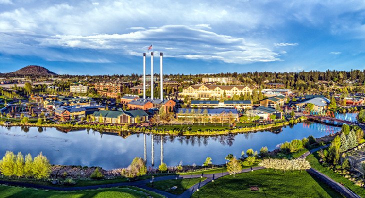
Bend sits roughly in the center of Oregon, edged by a mix of national forests, volcanoes, and dry plains. The city's High Desert Museum has informative displays about the surrounding arid regions.
Popular things to do in Bend include rafting trips on the Deschutes River, excursions to the volcanic landscapes of Lava Butte and Newberry National Volcanic Monument, and skiing at the large Mount Bachelor Ski Area. For an iconic waterfall of the area, Tumalo Falls can be reached from Bend in just over a 10-mile drive.
Also nearby, Smith Rock is famous with climbers for its many routes and long history as a rock-climbing destination. Hiking trails around Bend are a great way to explore these scenic areas, and mountain biking trails also add to the excitement.
For a more laid-back approach, Cascade Lakes Scenic Byway is a popular auto-touring route through the Deschutes National Forest. The drive passes lakes, mountains, and spectacular scenery with many picnic spots and campsites available along the way.
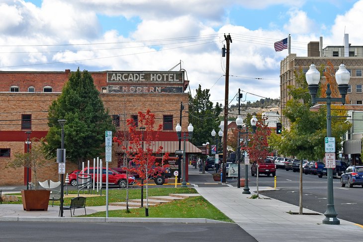
7. Astoria
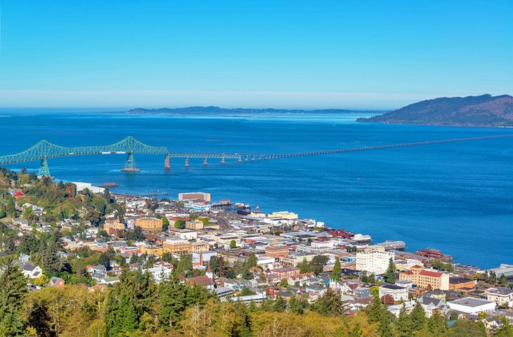
Astoria is a charming seaside city with inspiring surroundings in the far northwest corner of Oregon, near the end of the Columbia River before it meets the ocean. Although smaller, it's called the San Francisco of Oregon, thanks to its seaside status and vibrant downtown district filled with a community flavor.
Movie fans may recognize Astoria as the backdrop for the 80s cult-classic movie, The Goonies. Visitors to Astoria can learn more about this movie and other Oregon productions at the Oregon Film Museum, located in the old Clatsop County Jail.
Nearby, the Astoria Flavel House Museum provides historical insight into this well-aged city. Other top attractions of Astoria include the scenic Riverfront and the Astoria Column, both with great views of the area.
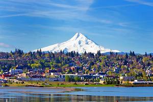
8. Hood River
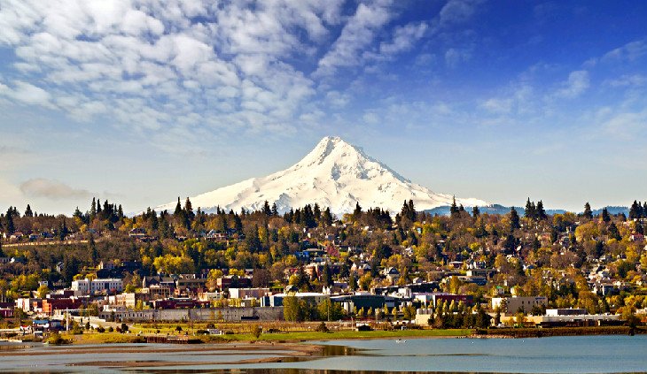
The scenic city of Hood River is on the banks of the Columbia River just over an hour east of Portland. It is a great place for sightseeing and outdoor sports and is well-known as a destination for kiteboarding and windsurfing. Other common things to do in this adventurous region include hiking, biking, and camping.
The city is also well regarded for its emerging culinary scene. Menus are often bolstered by fresh ingredients from the adjacent Hood River Valley. Even more tastes of the region are found on the 35-mile Fruit Loop, which runs from the city into the agricultural fields to the south.
Visitors wanting a little less physical activity can easily hop on the Historic Columbia River Scenic Byway to explore a lush world of waterfalls. The Mount Hood Railroad also departs from Hood River and travels 17 miles to Odell, with Mount Hood in view the entire way.
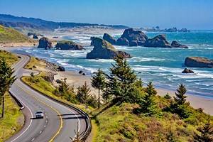
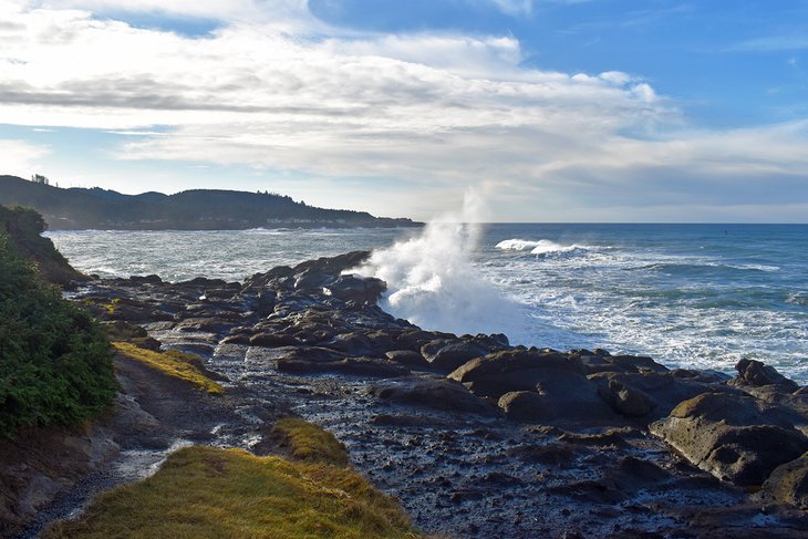
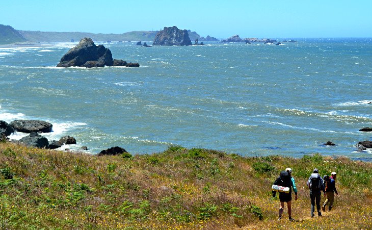
9. Samuel H. Boardman State Scenic Corridor, Brookings
The Samuel H. Boardman State Scenic Corridor is a 12-mile linear park between Brookings and Gold Beach on the southern Oregon coast. This stunning coastal corridor exhibits some of the best oceanside scenery in the state.
The park is named after the first Oregon Parks superintendent and is easily accessible from US 101. Various pull-offs line the entire park, connecting beaches, rock formations, and the distinct natural beauty that defines this part of the coast. The Oregon Coast Trail also spans the entire park, offering a very challenging day hike.
Most of the pull-offs in the state park lead to steep hiking trails that quickly descend to the beach, sometimes over rough terrain. A few popular pitstops along this scenic corridor include Arch Rock; Indian Sands; and one of the best beaches on the Oregon coast, Lone Ranch Beach. This beautiful beach is easily accessible with convenient parking nearby.
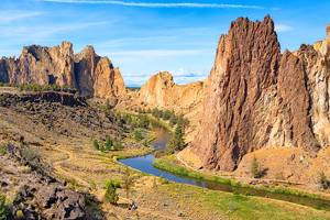
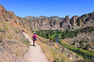
10. Smith Rock State Park, Terrebonne
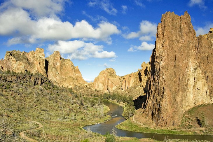
Smith Rock State Park is an international climbing destination in central Oregon, near Bend. The state park has over 1,000 bolted sport routes lining a stunning river canyon environment. These routes range from beginner to finger-crimping hard, and all require proper climbing experience and gear.
It's not just climbers who flock to this outdoor playground – mountain bikers, hikers, and photographers often explore the scenic surroundings of the state park. And with a high-desert weather system, climbing and exploring Smith Rock in winter is usually a T-shirt endeavor.
For one of the best hikes in the area, head to Misery Ridge. Despite its foreboding name, the trail provides a stunning view of the Crooked River and its canyon walls.
Smith Rock State Park has an RV-exclusive campground and a walk-in area for campers and climbers.
Official site: https://smithrock.com/
11. Oregon Shakespeare Festival, Ashland
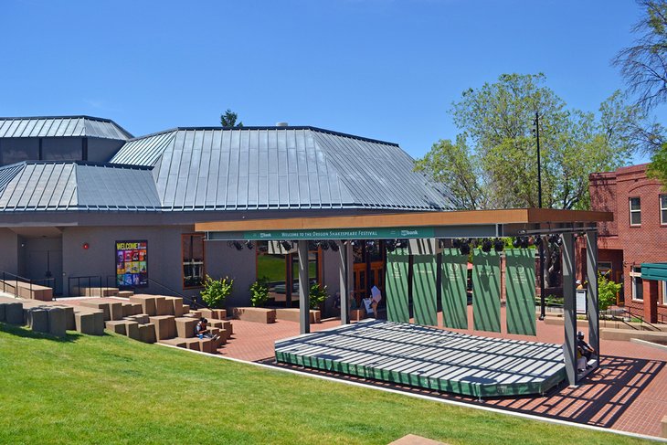
The world-renowned Oregon Shakespeare Festival takes place in Ashland for much of the year. This non-profit theater production puts on over 700 shows annually, spread across three stages, including the beautiful Allen Elizabethan Theatre. And catching any one of these performances is a quintessential Southern Oregon traveling experience.
With a season that spans February through October, alongside ample fanfare, the Oregon Shakespeare Festival greatly defines the community and culture of the surrounding city of Ashland. This is especially true in the downtown district, with Victorian-themed restaurants and shops throughout. Much of the audience tends to spill out of the theaters and onto these streets after a show.
Read More: Top-Rated Attractions & Things to Do in Ashland, Oregon
12. Newport
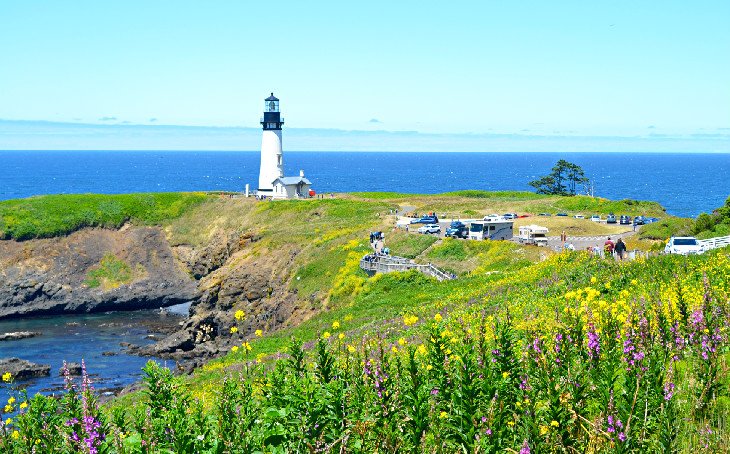
Family-friendly attractions line Newport on the Oregon coast, a city that mixes beach scenery with a distinct Victorian heritage. The Oregon Coast Aquarium and Hatfield Marine Science Center are often favorite places to visit, and to the north, the Yaquina Head Lighthouse is a beacon of coastal beauty.
Beaches abound in every direction from Newport. Its historic Nye Beach certainly ranks among the Best Beaches near Newport, with other sunset-capturing contenders like Agate Beach and South Beach State Park nearby.
The town is a good base camp for exploring the central coast and whale watching. The city's busy bayfront faces Yaquina Bay, home to a large fishing fleet. Extending from the sheltered bay, the city's wild Pacific beaches offer storm-surge rollers and unfiltered sunsets
13. Sisters
Sisters is a fun western-themed town on the west side of the Cascade Mountains, approximately a 30-minute drive from Bend. It's smaller than Bend and offers a more tourist-orientated community with a centralized downtown shopping area. This downtown area has a distinct western charm circa the 1880s, with old-fashioned storefronts housing several modern retailers.
Sisters is also a major basecamp for adventures. Willamette and Deschutes National Forests dominate the landscape immediately east, offering endless adventure throughout the year. Hop on the McKenzie Pass-Santiam Pass Scenic Byway, starting in sisters, for one of the best automobile loops in Oregon.
Read More: Top-Rated Things to Do in Sisters, Oregon
14. Silver Falls State Park, Sublimity
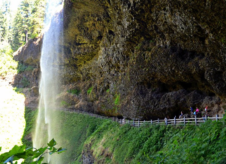
Silver Falls State Park is thirty minutes east of the state capital of Salem and provides perhaps the most dazzling display of waterfalls in the country. It's home to the nationally recognized Trail of Ten Falls, a moderate hiking path that tours the many water attractions of the area.
This jewel of the Oregon State Park system takes users behind a few waterfalls for an exciting perspective. One of these waterfall tunnels includes the largest waterfall in the area and one of the best waterfalls in Oregon, the stunning South Falls.
Visitors don't have to travel far to see the signature South Falls with the adjacent South Falls Day-Use Area nearby, with parking and visitor amenities like picnic tables and restrooms.
Address: 20024 Silver Falls Highway Southeast, Sublimity, Oregon
15. Depoe Bay
Depoe Bay is a seaside town with a stunning overlook of the Pacific Ocean. With its high vantage point and Main Street perched on the side of a cliff, it easily earns its reputation as the "Whale Watching Capital of the Oregon Coast." The Depoe Bay Whale Watching Center is the first place to go for information on how to spot these massive mammals.
Alongside the ocean sounds and vistas presented along the entire western edge of the town, Depoe Bay caters to an authentic Oregon coast vacation. Local taffy shops and seafood restaurants line the charming Main Street, next to the World's Smallest Harbor, where commercial fishing trips encourage a day of adventure.
Depoe Bay also lends easy access to a stunning section of the coast. Several public access points dot the elevated Depoe Bay coastline, lending to spectacular views come sunset, and areas like the Devil's Punchbowl and Yaquina Head are within a quick drive from Depoe Bay on the 101.
Read More: Top-Rated Things to Do in Depoe Bay
16. Newberry National Volcanic Monument
The Newberry Volcanic Monument provides a plethora of unique scenery to explore within the Deschutes National Forest of Central Oregon. It's centered around the Newberry Caldera and surrounds a 1,200-square-mile volcano. A great first stop when visiting the monument is the Lava Lands Visitor Center to learn more about this thermally active area.
Popular activities at Newberry include bicycling, hiking, and boating. One of the best campgrounds in Oregon is in Newberry, and those who nab a reservation at the popular Little Crater Campground have immediate access to the welcoming waters of Paulina Lake.
Several scenic hot springs are dug into the shoreline of Paulina Lake. From the campground, this thermal area is accessible by boat ride or moderate hike next to the water. It's approximately a three-mile round trip hike on an undulating lakeshore trail to reach the hot springs on foot.
17. Klamath Falls
Klamath Falls is a base camp for adventure in Southern Oregon. The town is one of many stops on the state-crossing Volcanic Legacy Scenic Byway. Crater Lake National Park is 90 minutes north on this bucket-list highway from Klamath Falls, and Lava Beds National Monument is less than 60 minutes south.
Outside of its nearby natural attractions, the city itself offers several attractions and things to do. The town's blessed with abundant sunshine throughout the year, and places like Moore Park and the Link River Trail offer plenty of space to explore outside.
Head to Klamath Fall's downtown district for cultural appeal, where history and modern taste combine for a fun visiting experience. Surrounding the downtown area, a collection of Klamath County Museums offers valuable insight into the region.
18. Oregon Dunes National Recreation Area
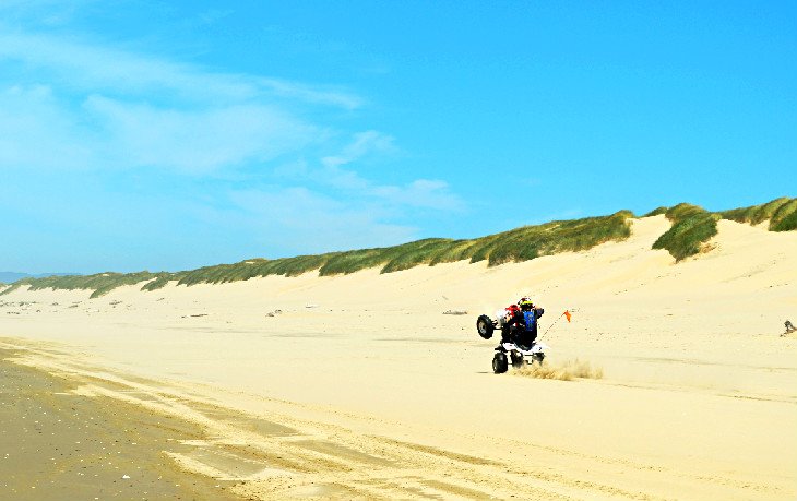
The dune landscape of Oregon Dunes National Recreation Area begins south of Florence and stretches along the Pacific Coast for about 40 miles before reaching Coos Bay. The National Recreation Area is within Siuslaw National Forest, near other scenic attractions such as Cape Perpetua and the Heceta Head Lighthouse.
The ocean and several pocket forests sandwich these miles of shifting dunes, offering tons of space to explore by foot or via off-highway vehicle. Popular destinations within the dunes include the Umpqua Dunes area at Winchester Bay and the sandboarding destination known as Sand Master Park in Florence.
For a great place to pitch a tent or park an RV, Jessie M. Honeyman Memorial State Park is located south of Florence and is one of the best campgrounds on the Oregon coast. It offers a popular place to access the sand dunes with horse and off-road vehicle staging areas.
Visitors to the dunes should be aware of snowy plovers and the restrictions put in place to protect their habitat.
19. Hells Canyon National Recreation Area
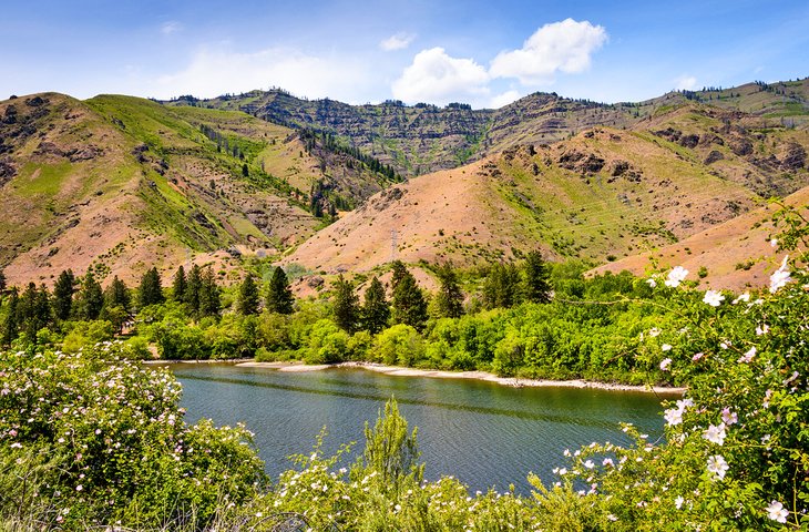
Hells Canyon is the deepest canyon in the United States. This rugged river canyon is in the extreme northeast of the state, straddling the Idaho border, and is managed within Wallowa-Whitman National Forest. This remote landscape is mainly inaccessible, but for the adventurous, it offers lengthy outdoor excursions like rafting and backpacking trips.
The Wild and Scenic Snake River runs at the bottom of the canyon and is a major bucket-list destination for whitewater boaters. Other popular activities at Hells Canyon include nature photography, wildlife spotting, fishing, and hiking. The Western Rim National Recreation Trail traverses the Oregon side of the canyon and provides excellent views for hikers and backpackers.
For those traveling by car, the Hells Canyon National Scenic Byway departs from Baker City and La Grande, with side trips to Hells Canyon Dam and viewpoints.
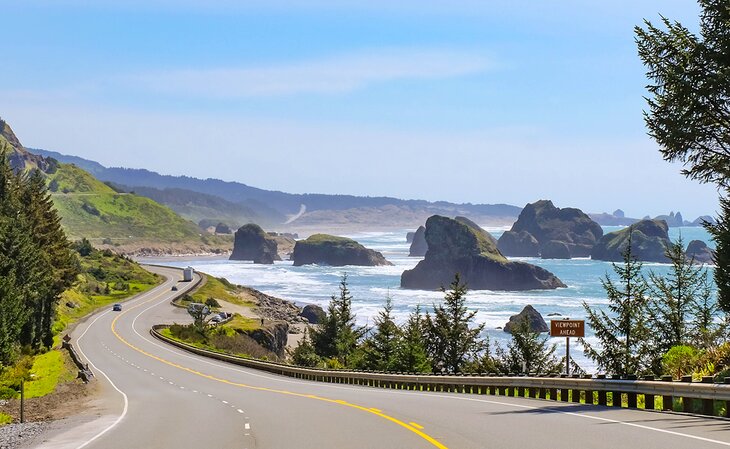
20. Oregon Coast Trail
The Oregon Coast Trail (OCT) stretches for over 360 miles along the western edge of Oregon, taking in the sights, sounds, and top attractions of the Oregon coast.
Most tackle the Oregon Coast Trail in segments, doing three to five days at a time and covering 20 to 30 miles. Several campgrounds along the trail consist of state parks, with hiker/biker sites set aside. Reservations aren't needed for hiker/biker sites, though everyone has to arrive via muscle-powered transportation.
While the trail mostly sticks to beaches, hikers on the OCT navigate forested headlands, catch boat rides across estuaries, and follow along the shoulder of the US 101 for portions of the trek. Research is needed before any trip to solidify logistics like campgrounds and estuary crossings.
21. Willamette National Forest
The vast Willamette National Forest covers nearly 1.7 million acres on the western slopes of the Cascade Mountains. The forest contains spectacular scenery, including several volcanoes, mountains, rivers, and some of the best hot springs in Oregon.
Visitors can explore trails or head to attractions such as the Dee Wright Observatory (a stone tower atop McKenzie Pass) or the 280-foot Salt Creek Falls. The famous Three Sisters Wilderness is also accessible within Willamette National Forest.
This region of the state is particularly dense with national forests. Directly to the east, the Deschutes National Forest is just as popular for recreation. And to the north, Mount Hood National Forest surrounds the impressive peak for which it's named.
22. Willamette Heritage Center at The Mill, Salem
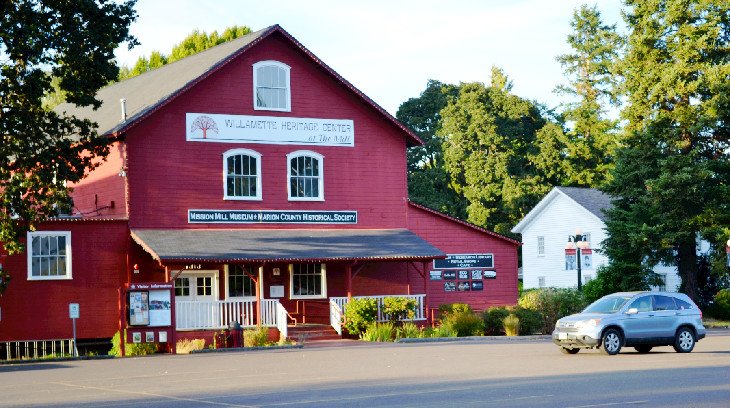
Salem is the state capital of Oregon. It's within the Willamette Valley and home to historic theaters, family-favorite carousels, and an Enchanted Forest. Other top attractions of Salem include Riverfront City Park, the State Capitol building, and the Willamette Heritage Center.
The Heritage Center looks at the life and industrialization of the Willamette Valley in the late 1800s. It's spread across five acres and centers on the Thomas Kay Woolen Mill, dating to 1895. Alongside the large red structure, other historic wooden buildings are brought to life by exhibits and interpretive guides.
Address: 1313 Mill Street Southeast, Salem, Oregon
23. Jordan Schnitzer Museum of Art, Eugene
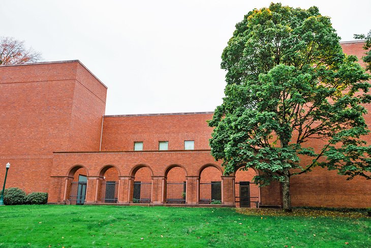
This windowless museum in Eugene is designed to protect its art treasures. The wide-reaching collection features primarily Asian artworks and pieces from America and Europe.
Opened in 1933, the museum is located on the University of Oregon campus, where other attractions include the Museum of Natural and Cultural History and a historic track at Hayward Field.
Guided tours of the museum are available on the first Saturday of every month and are included with the cost of admission.
Address: 1430 Johnson Lane, Eugene, Oregon
Official site: http://jsma.uoregon.edu/
24. Oregon Caves National Monument and Preserve
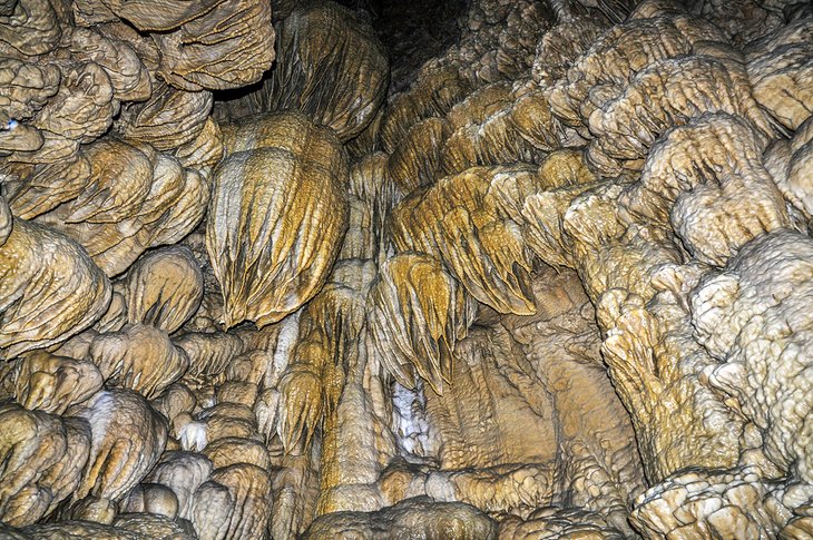
This subterranean attraction centers on a marble cave, accessible only during guided tours. The National Park Service offers a variety of tours that explore the cave, ranging from guided treks for families and kids to wild cave expeditions that veer off the typical tourist path.
Above the surface, the protected area offers hiking trails through old-growth coniferous forests. The monument sits at 4,000 feet elevation in the Siskiyou Mountains. Seventeen primitive campsites are available at the monument's Cave Creek Campground, located approximately four miles from the cave entrance.
Address: 19000 Caves Highway, Cave Junction, Oregon
25. Medford

Medford is the largest city in Southern Oregon and a hot spot for travel and vacations. It's the heart of the Rogue River Valley, tying the city to an agriculturally rich region and several natural playgrounds.
Outdoor adventures stemming from Medford include jet boat tours of the Rogue River and climbing to the top of the culturally significant Table Rock formations. Prescott Park is a local favorite place to explore, encompassing one of the most prominent peaks closest to the city, Roxy Ann Peak.
Medford is also a hub for culture in Southern Oregon. Its larger population lends to more shopping malls and big-box retailers. But the downtown district, with local shops lining the streets, is the best place to experience the Medford community.
Read More: Top-Rated Attractions & Things to Do in Medford, OR