Tourist Attractions in Eindhoven, Netherlands
The largest town in the southern part of the Netherlands and the fifth-largest in the country, Eindhoven isn't a destination that tourists usually think of — which is a pity.
Located in a picturesque setting on the River Dommel, Eindhoven offers a number of great attractions and numerous rewarding things to do, from exploring its great museums to discovering its deep connections with famed artist Vincent Van Gogh.
Because of its connections with electronics giant Philips, Eindhoven has been given the nickname of "Lichtstad," or the City of Light. Over 130 years old, this now-massive company is one of the country's industrial powerhouses, a fact that's very much evident pretty much anywhere you go in the city.
To learn more about these and other great places to visit in the city, along with some of the best sightseeing opportunities in the Netherlands, be sure to review our list of the top attractions in Eindhoven.
The Van Abbemuseum
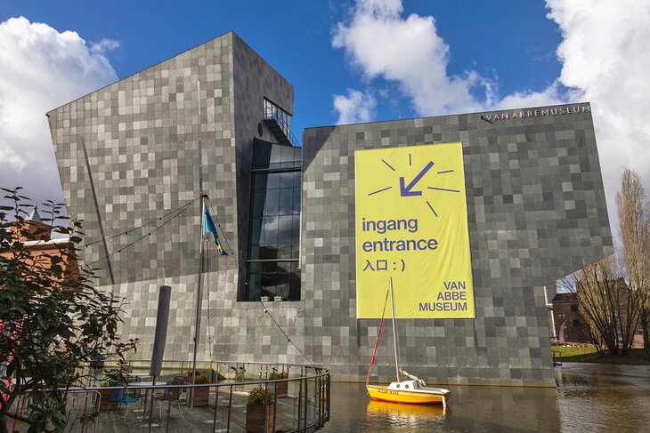
Founded in 1936 and housed in one of the city's most interesting modern buildings, the Van Abbemuseum is one of the most important galleries of modern and contemporary art in the Netherlands. Highlights of its more than 2,700 artworks include pieces by modern painters such as Marc Chagall and Pablo Picasso.
It's also home to the world's largest collection of material by the influential Russian artist and designer, El Lissitzky. Other notable collections include numerous sculptures and art installations.
Video works and posters can also be seen, including a large Paris collection from Jacqueline de Jong, as well as examples from the USA, Germany, and Eastern Europe. A gift shop and café are located on-site.
Address: Tongelresestraat 27, 5613 DA Eindhoven, Netherlands
Read More: Places to Visit in the Netherlands
The DAF Museum
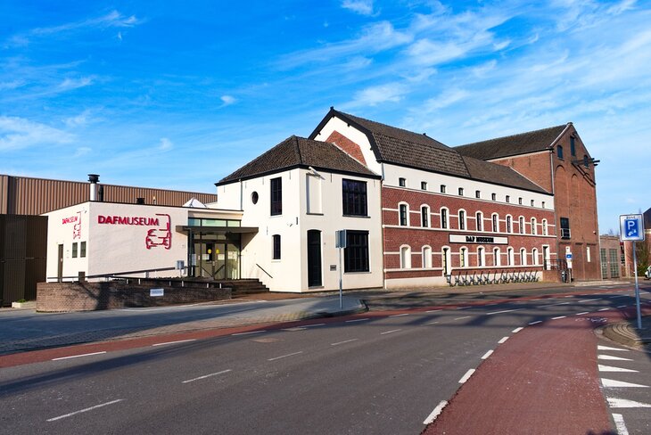
Eindhoven has been home to DAF, one of Europe's largest truck manufacturers, and at one time, cars, since the company's founding in 1928.
Short for Van Doorne's Aanhangwagen Fabriek, the company was founded by brothers Hub and Wim Van Doorne in a small blacksmith's shop. From humble beginnings making simple engineering products, the company gradually progressed from trailers to cars and trucks.
One of the most popular museums in the southern Netherlands, the DAF Museum is a testament to the company's success. Highlights include a replica of the original workshops and offices, along with samples of its vehicles throughout the decades, including a number of prototypes.
Guided tours are available, and a shop and restaurant are located on the premises.
Address: Tongelresestraat 27, 5613 DA Eindhoven, Netherlands
Read More: Cities in the Netherlands
The PSV Museum
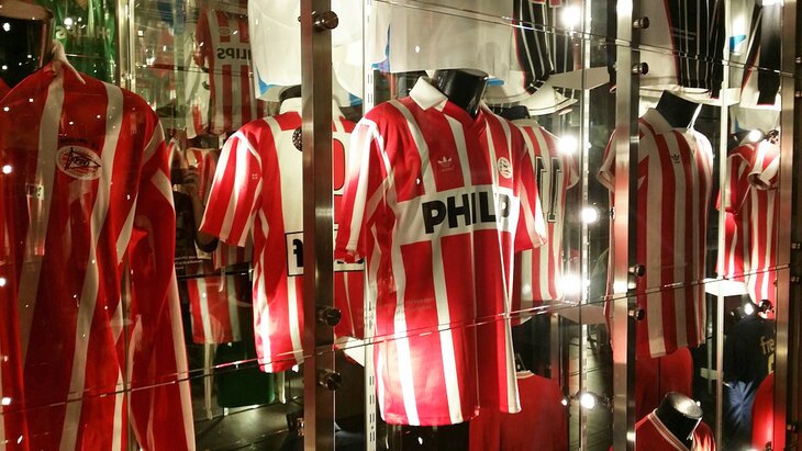
Calling Eindhoven football-obsessed is an understatement. But such claims seem reasonable when you're home to Philips Sport Vereniging (PSV), one of the most successful football (soccer) franchises in Europe. And with the club fast approaching its 110th anniversary in 2024, there's plenty of history on display at the PSV Museum (PSV Musée).
Highlights of a visit include the chance to see historic outfits and artifacts as well as photos and film footage of career highlights. English-language guided tours of the team's Philips Stadium (Philips Stadion Eindhoven) are also available and include packages that take in team practices, so you can see the players in action.
Address: Stadionplein 4, 5616 RX Eindhoven, Netherlands
St. Catherine's Church
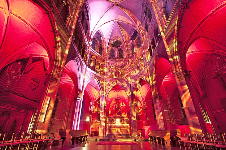
Attractive St. Catherine's Church (St. Catharinakerk) was built in Neo-Gothic style in 1867. The original building, dedicated to St. Catherine of Alexandria, was consecrated in the 13th century and was many times severely damaged by war and fire, even spending part of the 18th century as a stables and weapons store.
Now fully restored, the current structure incorporates a number of symbolic references to the work of Joseph Thijm, one of the country's best-known writers. Highlights of a visit include seeing its twin French Gothic towers, each 73 meters tall and known respectively as David and Maria.
Interior highlights include its stained-glass windows and its two organs, one of them with 5,723 pipes.
Address: Catharinaplein 1, 5611 DE Eindhoven, Netherlands
The Philips Museum & Collection
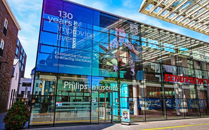
Housed near the original factory where Gerard Philips made his first incandescent light bulbs in the 1890s, the Philips Museum shows how this once-small enterprise has grown to become one of the world's largest electronics companies. A visit to this ultra-modern attraction gives visitors an excellent overview of the company's success, as well as the workings of its most memorable products.
One of the museum's most popular features is Mission Eureka, an interactive game involving digital quizzes and puzzles. There are also many other fun interactive exhibits that children enjoy. English-language guided tours of the museum and Philips-related city landmarks are available.
Art fans will also want to include the top-notch Phillips Collection on their list of must-visits in Eindhoven. Established in 1921, the museum houses a large contemporary art collection of some 3,000 works from around the world.
Guided tours are available. A café and shop are located on-site.
Address: Emmasingel 31, 5611 AZ Eindhoven, Netherlands
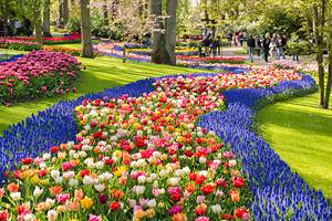
Van Gogh Village Museum, Nuenen
Take a drive just eight kilometers northeast of Eindhoven and you'll come to the picture-perfect village of Nuenen.
Known as the Van Gogh Village Museum, it's famous the world over for its inclusion in the art of Vincent Van Gogh, who lived here from 1883 to 1885. His temporary home was in the pastor's house, which has been completely restored to its original style and is one of 21 historic buildings preserved on the site.
A highlight of a visit is the Vincentre. This excellent and recently expanded attraction is dedicated to the artist and his time in Nuenen, and is the focal point of many great walks following in Van Gogh's footsteps. These self-guided tours through what's referred to as The Outdoor Museum lead you to more than 20 different locations spread around the village that relate to the artist.
In addition to the latest audiovisual technology, audio commentary brings the life and times of one of Europe's most revered painters to life in a fascinating fashion.
Address: Berg 29, 5671 CA Nuenen, Netherlands
The Prehistoric Village (PreHistorisch Dorp)
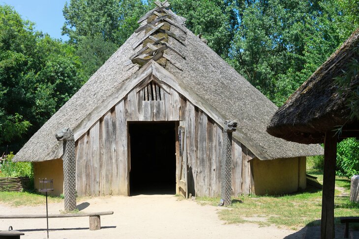
One of the most unusual attractions in Eindhoven, PreHistorisch Dorp, or the "Prehistoric Village," is a replica of an ancient community complete with dwellings and demonstrations of skills used by prehistoric people. This fun open-air museum recreates life from this and later eras, including Roman and early medieval times.
In North Brabant (Noord Brabant), the second largest of the Dutch provinces, agriculture was once the main livelihood before the textile, electrical, and metalworking industries blossomed after 1900. As a result, most of the settlements in the province were small hamlets and villages with farms growing crops such as rye, potatoes, oats, and fodder plants for dairy cattle.
At PreHistorisch Dorp, costumed interpreters bring the history of this province to life, going about everyday tasks and interacting with visitors in a variety of fun interactive programs and hands-on workshops. These might include learning to make a fire as prehistoric people did, baking bread on a stick, or learning how to make a Roman fibula, a form of garment pin popular 2000 years ago.
Prehistoric farming methods, hand weaving and spinning, metalwork, and other skills are also demonstrated and discussed here. Although very engaging for children, this is an experience for all ages. All signage is in English, as well as Dutch, and guided tours are available.
Address: Boutenslaan 161B, 5644 TV Eindhoven, Netherlands
GLOW and other Eindhoven Festivals
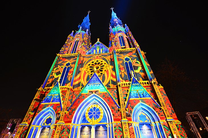
In mid-November each year, Eindhoven hosts an international light art festival known as "GLOW." This popular winter event features light artists from all over the world who transform the city into a wonderland of spectacular displays of colored lights.
More than 30 illuminations transform streets and buildings each night. Perhaps the most breathtaking of all these is the illumination of the façade of Saint Catherine's Church, picking out its architectural details in different colors.
Another important annual festival is Lichtjesroute, held each autumn to mark the city's liberation from German occupation in 1944.
Eindhoven is home to a number of first-rate concert venues and theaters, including the spaceship-like Evoluon, former home of the Philips Science Center, and now a conference center and music venue known for hosting major European groups.
Address: Willemstraat 1F, 5611 HA Eindhoven
Read More: Places to Spend Christmas in Europe
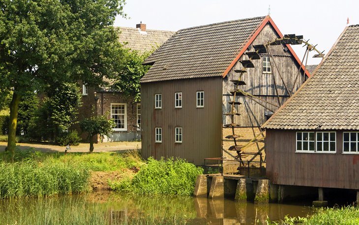
Genneper Parken and Stadswandelpark
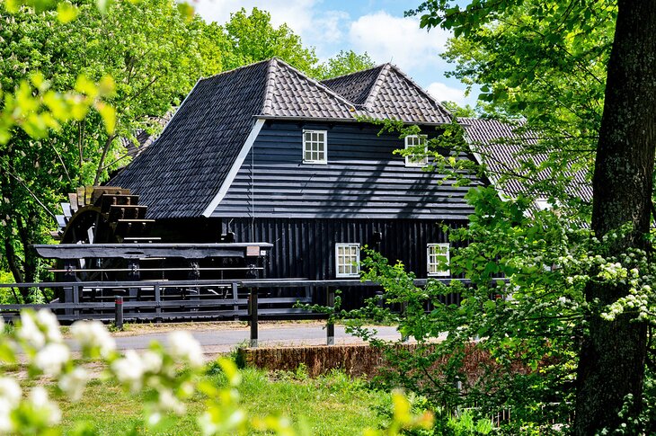
Eindhoven is blessed with a number of excellent green spaces providing locals and visitors with ample room to relax. One of the most popular is Genneper Parken. This nearly 500-acre green space is set in a pretty location on the Tongelreep and Dommel rivers in a valley conservation area.
You'll have fun exploring its well-marked, meandering trails to discover such landmarks as the Genneper Watermill and the neighboring Environmental Education Center, with exhibits relating to the area's flora and fauna.
Also noteworthy is City Park (Stadswandelpark), a popular place for a stroll thanks to its 30 unique sculptures. You'll also wander past monuments such as the Radio Monument, celebrating the first radio communications with the Dutch East Indies in 1927.
Address: Antoon Coolenlaan 1, Eindhoven, Netherlands
Dierenrijk Zoo

If you're looking for things to do with the family, Dierenrijk Zoo is a great place to visit. Here, the emphasis is on up-close encounters and interactions with the resident wildlife. Children can get close to such appealing animals as the red panda, and can feed many of them.
Elephants and seals perform, and glass walls allow close encounters even with large animals like bears and tigers. Visitors can walk through the bird enclosure. There are playgrounds and exhibits indoors and outside, so this is an all-weather attraction.
Address: Baroniehei 1, 5731 RG Mierlo, Netherlands
Inkijkmuseum and Ton Smits Huis
The Inkijkmuseum is not only one of Eindhoven's most interesting museums, it's also certainly the city's smallest. Literally translated as a "look-in" museum, it's housed in what was the washhouse of a former linen factory. The ground floor of this fascinating little museum is viewed by peeking through its windows at the often-changing artworks inside.
Another art-related home to visit is the Ton Smits Huis, a museum in the former studio of one of the Netherlands' most famous cartoonists.
Address: Jacob Reviuslaan 25, Eindhoven, Netherlands
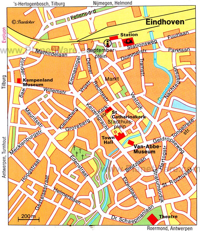
Map of Tourist Attractions in Eindhoven, Netherlands