Tourist Attractions in Nepal
Nepal is a surprisingly diverse country that attracts visitors for many reasons. Some are lured by the call of the mountains and seek to climb or trek in the Himalayas, others are intrigued by the culture and the famous city of Kathmandu, and yet others come hoping to find some sort of spiritual awakening. Nepal can be an adrenaline adventure, a cultural eye opener, a life-changing experience, or all of the above.
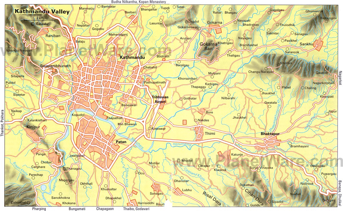
Most travelers spend some time in Kathmandu visiting sacred and historic attractions, and then head out to other parts of the country. Some of the best places to visit outside the capital are Chitwan National Park and Bardiya National Park for wildlife viewing, and the lakeside town of Pokhara, a popular area for embarking on treks.
Trekkers will find a variety of options across Nepal, with the most important areas being the Everest, Annapurna, and Langtang regions. Nepal no longer allows independent trekking; all foreign trekkers must hire a licensed guide.
You can book a guide before you arrive in the country through online companies or once you arrive in Nepal. Booking from within Nepal will almost always be cheaper. If you are hiking out of Pokhara, there are many agencies offering guides and packages. Agencies tend to promote all-inclusive packages with hotels and meals, which can be very expensive and unnecessary, but you will need a guide.
In 2015, a major earthquake struck Nepal, causing severe damage in Kathmandu and other areas. Extensive renovations have restored major tourist attractions, but some historical treasures were lost forever.
To find the best places to visit, have a read through our list of Nepal's most impressive tourist attractions.
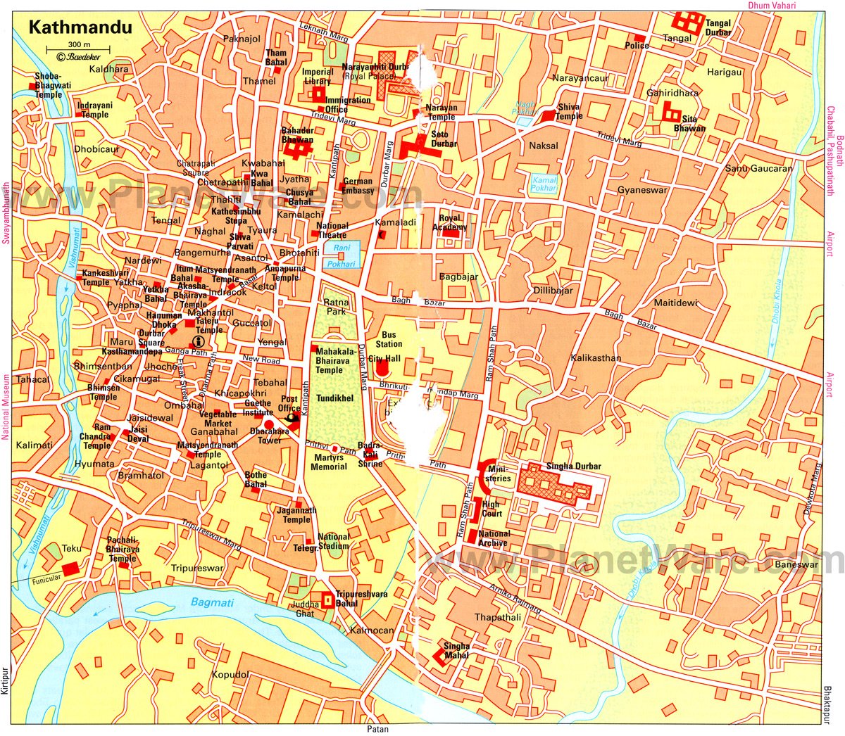
Kathmandu
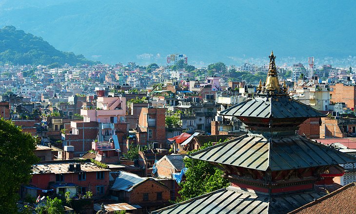
Kathmandu, the capital and largest city in Nepal, is like no other city in the world. The decaying buildings in the heart of the city are a stark contrast to the lively atmosphere that permeates the streets. The smell of incense wafts from stores while street sellers push their goods, and people go about their daily lives, all against a backdrop of historic temples and carved statues.
For several hundred years, Kathmandu was one of three rival royal cities, along with Bhaktapur and Patan. Situated in close proximity to each other, today these three almost run together.
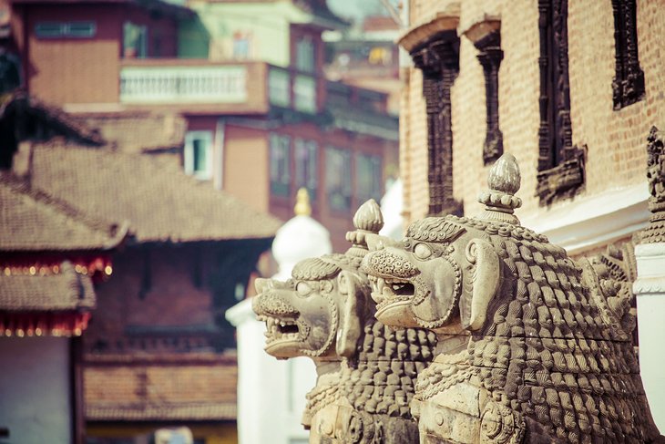
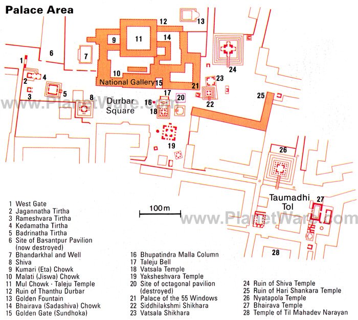
The highlight of Kathmandu has long been Durbar Square, the largest of the palace squares in the three royal cities and a UNESCO World Heritage Site. Temples and monuments of varying shapes, sizes, styles, and faiths can be found here.
Kathmandu's Durbar Square was severely damaged in the 2015 earthquake, with many buildings destroyed beyond repair, but it still remains a special place to visit.
Bhaktapur
Bhaktapur, the third of the "Royal Cities," lies on the old trade route to Tibet, just outside of Kathmandu. For Bhaktapur, the trade route was both an arterial link and a major source of wealth. Its relative remoteness at the time allowed the city to develop independently and in ways that distinguish it from the other two cities.
In contrast to Patan and Kathmandu, the population of Bhaktapur is primarily Hindu. The best place from which to begin a tour of the city is Durbar Square, where, in addition to the royal palace, several temples are also situated. The whole area is a UNESCO World Heritage Site.
Many of the buildings in Durbar Square in Bhaktapur were damaged in the 2015 earthquake, but restoration work is now largely complete.
Boudhanath Stupa (Bodhnath)
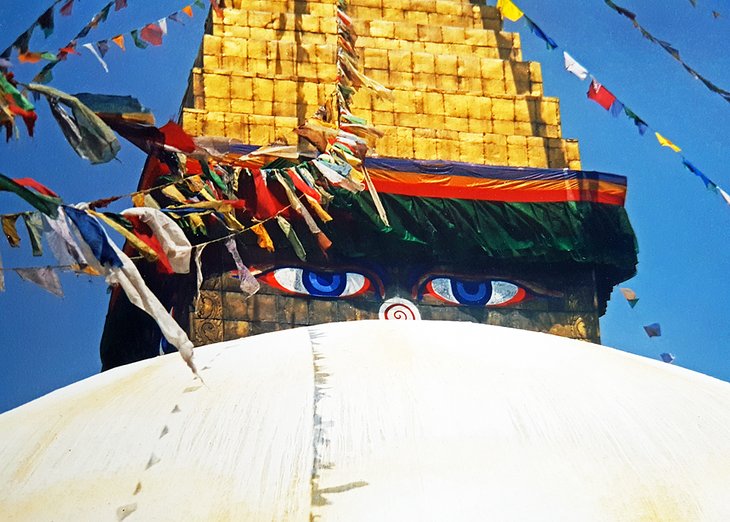
The Bodhanath Stupa, just outside Kathmandu, is one of the largest stupas of its kind in the world and dates to some time around the 6th century, possibly even earlier. Like Bhaktapur, it lies on the old trade route to Tibet and is a UNESCO World Heritage Site.
The stupa itself is a symbol of enlightenment, but at Boudhanath, the symbolism is particularly clear. Each different shape represents one of the five elements, earth, water, fire, air, and sphere, which are also the attributes of the five Buddhas. Brought together in the form of the stupa, their unity reflects in abstract fashion the structure of the universe itself.
The stupa sustained minor damage during the 2015 earthquake and is now fully repaired.
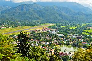
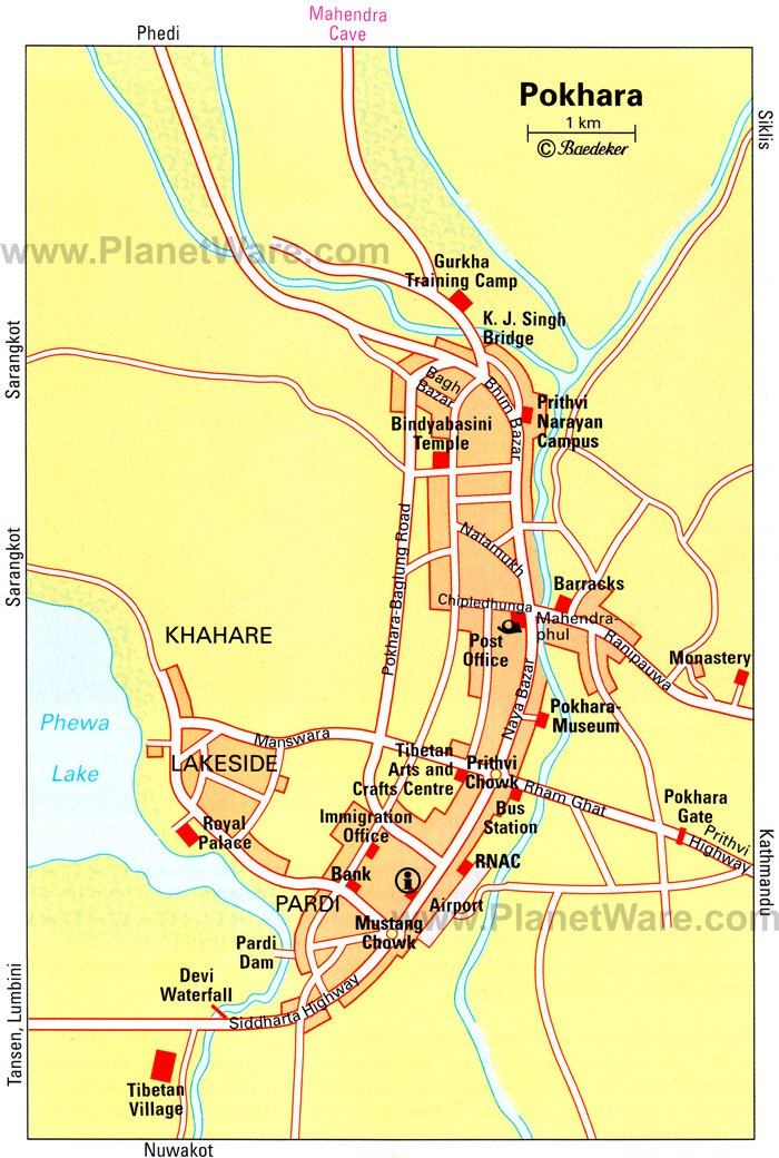
Pokhara
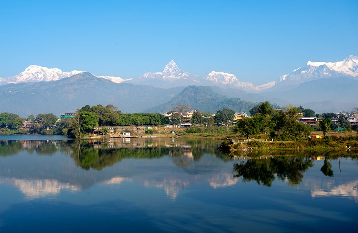
Set at the base of the foothills and surrounded by some of the highest mountains in the world – Dhaulagiri, Manaslu, and Annapurna I – Pokhara is one of Nepal's most scenic cities. For trekkers, Pokhara is the gateway to the Himalayas and the starting point for treks to Jomsom and the Annapurna region. It's also a wonderful spot to relax for a bit, either before or after a hiking trip.
By population, it is the second largest city in Nepal after Kathmandu, but still does not feel like a big city. As you travel from Kathmandu, 200 kilometers to the east, you'll notice the much cleaner air and pleasant climate almost immediately. Lake Phewa, with its cluster of lakeside hotels, restaurants, and shops, is ideal for those looking for a little relaxation.
You can also reach Pokhara by air. The new Pokhara Regional International Airport (PKR) opened in 2023 and has regular flights to Kathmandu.
Trekking in the Annapurna Region
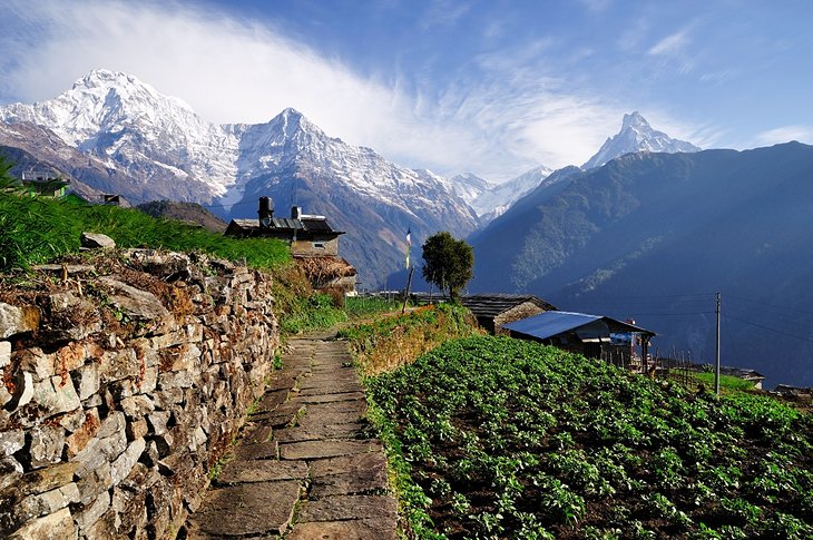
The Annapurna Region is one of the most popular trekking regions in Nepal, with options that range from a few days to a few weeks. Three main routes in the Annapurna Region intersect and combine in places, and you can opt to do a portion or a variation on the routes. The routes are well marked and easy to follow.
The Annapurna Circuit around Annapurna Mountain was once the classic, must-do hike in Nepal, taking about 21 days to complete. It is sometimes called the "Apple Pie Circuit," in reference to the fact that most of the teahouses along the route serve their own version of fried apple pie. However, this route is less popular now that you can reach well into the trekking area by road. It is still a beautiful area, but no longer offers the remote, isolated trekking experience it once did.
A popular hiking destination in this region, often offered in hiking packages in combination with the Annapurna Circuit, is the trek to Poon Hill (3,210 meters) near Ghorepani. Most hikers try to be on Poon Hill early to see sunrise and a stunning view of Dhaulagiri, Annapurna South, Machapuchare, and Singa Chuli.
The Annapurna Sanctuary nestles between the peaks of Annapurna and takes five days to reach. Muktinath is on the way to Annapurna but has since become a destination in its own right. The Muktinath route runs in the Kali Gandaki Valley on the east flank of Annapurna and takes seven days. North of Muktinath is Mustang, a small region with its own fascinating culture.
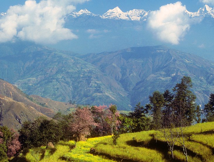
In many regards, the Annapurna Region, north of Pokhara, is an ideal walking area. The dramatic contrasts of the Nepalese countryside are especially visible, from the subtropical vegetation of the Pokhara Valley to the dry rain shadow area, with features of the Tibetan plateau. The people and cultures are also very different: facial characteristics, food, houses, lifestyles, customs, and religion.
The Annapurna region was declared a protected area in 1986. Most importantly, it has a good infrastructure to support the many trekkers that come through this area. The paths are well maintained, and food and lodging are plentiful.
Trekkers need specific permits, namely the Annapurna Conservation Area Permit (ACAP) and the Trekkers' Information Management System (TIMS) card.
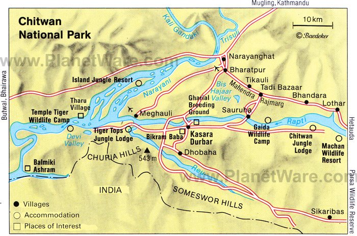
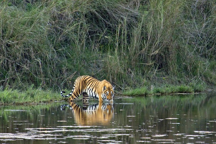
Chitwan National Park
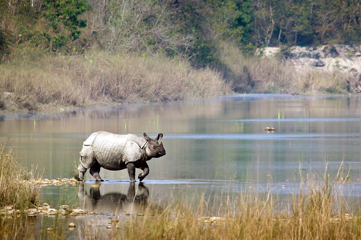
Chitwan National Park is the place to come to experience a different side of Nepal. This is a wonderful place for wildlife viewing and it has a safari-type atmosphere. At an altitude of only 100 meters in some areas, much lower than Kathmandu at 1,400 meters, Chitwan has a tropical monsoon climate, quite different than what you'd expect to find in Nepal.
Travelers come here to see wildlife. The park is home to rhinos, Bengal tigers, leopards, sloth bears, gaur (buffalo), deer, and many other critters. Freshwater dolphins (gangetic) and crocodiles inhabit the rivers and streams but are rarely seen. More than 500 species of birds make Chitwan a paradise for ornithologists. Tours from the lodges take you out into the park, either on foot, jeep safaris, or canoe trips, to get a closer look at the wildlife.
Chitwan lies southwest of Kathmandu, close to the Indian frontier, and is included in the UNESCO list of world cultural heritage sites.
The best time to visit Chitwan is from October to February. Average temperatures hover around 25 degrees Celsius (77 degrees Fahrenheit), with high humidity, although the mornings can be quite cool. June to September is the monsoon season, with frequent and heavy rain.
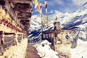
Trekking in the Langtang Region
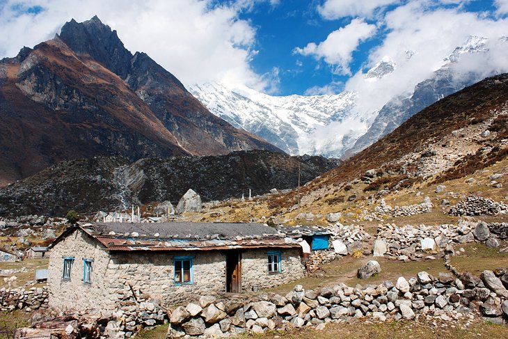
The Langtang Region, home to Langtang National Park, is an incredible area for hiking, with high passes, extensive views, old monasteries, and beautiful mountain scenery. Rhododendron forests bloom during the spring hiking season, adding color to the vistas.
The region suffered a devastating earthquake in 2015 that destroyed Langtang village. However, the area has recovered tremendously since then and is once again open to trekking and is one of the most popular hiking regions in Nepal.
The region, home to the Sherpa people, is less developed than some of the other popular trekking areas in Nepal and generally less busy on the trails, despite its close proximity to Kathmandu. Villages with guesthouses and food can be found along the route, although somewhat more spread out than in other trekking regions.
This area can be reached easily from Kathmandu by jeep in seven to eight hours. On a clear day, the peak of Langtang Lirung (7,245 meters), which dominates the surrounding area of the same name, is visible from Kathmandu.
Trekking lengths and durations in the Langtang range from a few days to a couple of weeks, depending on the routing. Some trekkers combine Helambu and Langtang for a longer trek.
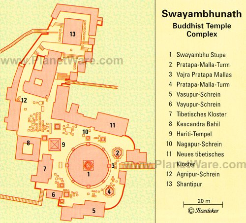
Swayambhunath (Monkey Temple)
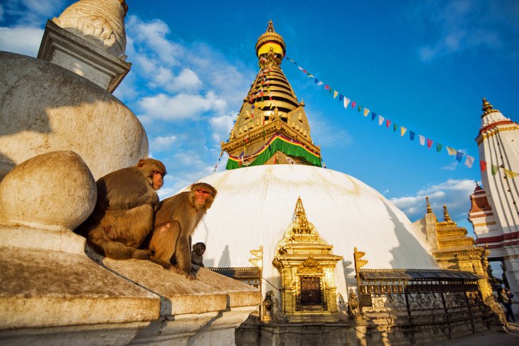
Set on a hilltop to the west of Kathmandu, Swayambhunath is the second most important shrine in the Kathmandu Valley after Boudhanath. Due to the resident monkeys that inhabit parts of the temple, it is more affectionately known as the Monkey Temple.
The Swayambhu Stupa, painted with the eyes of the omnipresent god, forms the centerpiece of the temple complex. It was originally a prehistoric cult site, but the temple complex dates to the 5th century. Swayambhu plays a major part in the lives of the Vajrayana Buddhists of Northern Nepal and Tibet, but especially of the Newari Buddhists of the Kathmandu Valley.
The 2015 earthquake caused some damage to the Swayambhunath temple complex; however, repairs are now complete, and the temple is back to its original condition.
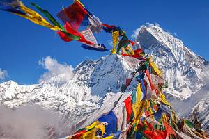
Everest & the Trek to Base Camp
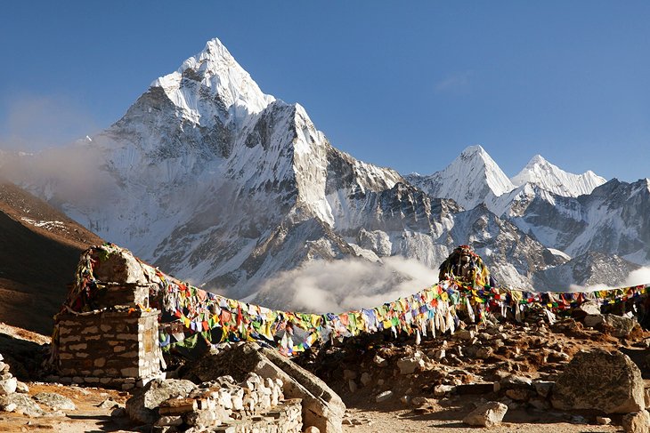
The summit of Mount Everest, the highest mountain on Earth, reaches just shy of 8,849 meters (29,032 feet) high. Trekking in the Mount Everest area became popular following the now legendary first ascent of the peak in 1953 by Edmund Hillary from New Zealand and the Sherpa Tenzing Norgay.
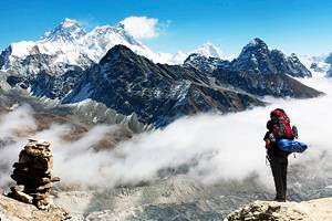
Since that time, many more have summited the mountain, but far more trek the route to Everest Base Camp simply for a glimpse of the peak far above. In recent years, the mountain has seen its fair share of tragedy and drama. The 2015 earthquake and previous avalanches, along with disputes between climbers on the mountain, have left their mark on Everest trekking and climbing.
The Everest Region is generally not regarded as the most scenic region in the country for trekking, but the allure of Everest makes it a popular destination, both for climbers and trekkers. There are various routes to access base camp.
Many trekking companies offer a guided hike, either with Nepalese companies or Western-based companies. The main hiking seasons are in the spring and fall, from March to May and September to December.
For those not looking to trek to Mount Everest but still wanting to see the mountain, it is possible to see it on clear days from the hill town of Nagarkot near Kathmandu. Hotel staff will knock on guests' doors on clear mornings if Everest is visible. This might be the lazy traveler's best chance of seeing the world's highest peak.
Bardiya National Park
Many people are surprised to learn that Nepal has extensive lowland areas where Bengal tigers, rhinos, crocodiles, and elephants roam. One of the best spots to see these animals in their natural habitat is Bardiya National Park (also Bardia National Park). In addition to the large animals, the park is also a bird-watching hot spot, with over 400 species either living in or transiting through the region.
Located off on its own in northwest Nepal near the border of India, this area is known for its river valleys, extensive grasslands, and tropical forest dominated by the Sal tree. Areas of the national park were once the exclusive hunting domain of Nepali royalty. Through the years, it has been expanded and now encompasses 968 square kilometers.
Pashupatinath Temple
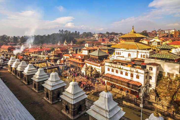
Dating from the turn of the 17th century, the Pashupatinath Temple is the oldest temple in Kathmandu and also considered one of the most sacred in Nepal. Located in western Kathmandu along the Bagmati River, the temple is known for its beautiful pagoda-style architecture, with copper and gold covering.
The temple is dedicated to Pashupati, one of the incarnations of Shiva. Of the three gates, only the western one is open, and only practicing Hindus of South Asian descent are allowed inside. A good viewpoint of the complex for non-Hindus is located across the river. One note of caution: the monkeys that hang out around this area may look cute, but they tend to be aggressive and should be treated with caution.
Open-air cremation ceremonies take place here on the ghats along the Bagmati River.
International Mountain Museum
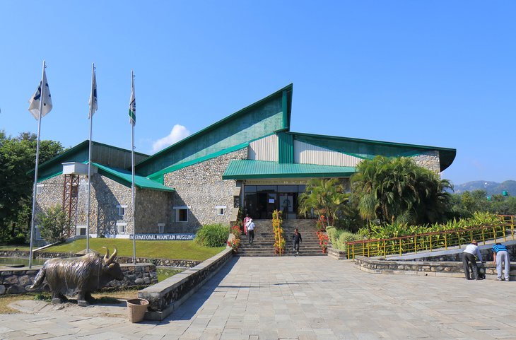
Located in the beautiful mountain town of Pokhara, the International Mountain Museum is a must-see prior to heading off on a trek. This very impressive modern building is a bright and airy space and houses all the information you could ever want to know about the mountains of Nepal and the people who inhabit them.
Three main galleries are spread throughout the museum, the first being the Mountain People Gallery. Here, through exhibits and a video, you'll learn about the Indigenous people of Nepal and the Khumbu region in particular.
The second gallery deals with the mountains themselves and provides extensive information on 14 peaks over 8,000 meters, along with an overview of the geology that formed them.
The third gallery provides insight into equipment used in mountain climbing and delves into the mythology of the secretive Yeti. In addition to the galleries, a Lakhang room is available for quiet contemplation.
If you're looking for other things to do nearby, outside is a tall triangular climbing wall along with a smaller version for those less inclined.
Official site: https://www.internationalmountainmuseum.org/
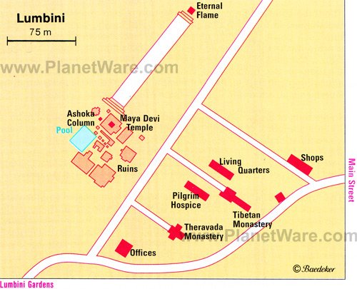
Lumbini
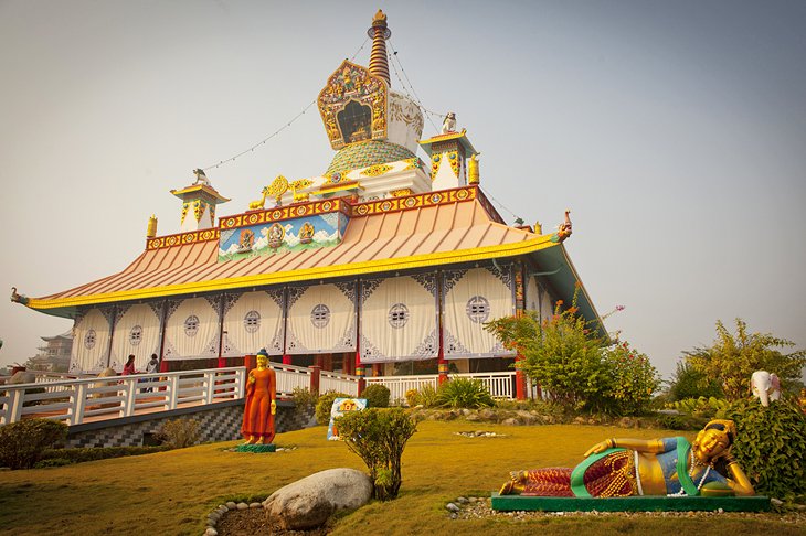
Lumbini is famous for being the birthplace of Siddhartha Gautama, the historic Buddha, known as Buddha Shakyamuni. Situated off the main tourist track, almost 250 kilometers from Kathmandu, Lumbini is a worthwhile detour on the route from Pokhara to the Chitwan National Park.
In this pilgrimage town, a UNESCO World Heritage Site, there is a feeling of tranquility. Most of the visitors are Buddhist pilgrims from around the world, retracing Buddha's footsteps through the stations of his life. The Maya Devi Temple, dedicated to Buddha's mother, is believed to be the spot where Buddha was born. It contains an ancient stone relief from the 2nd century AD depicting Buddha's birth.
Helambu Trek
The Helambu region is a popular trekking area. This is primarily because it is close to Kathmandu, does not reach astoundingly high elevations, and offers some beautiful mountain scenery.
For many of these same reasons, it is often touted by tour groups as being easy. However, many hikers who come here on tours find it is more demanding than they feel they were led to believe and more difficult than they anticipate.
Trekking in the Himalayas is always demanding, and although it is not as high as other treks, it is still a moderately strenuous hike, and trekkers should be in good physical condition. With that in mind, this is a beautiful trek, with stunning rhododendron trees in bloom in March and April, and it's well worth the effort.
The Helambu region is inhabited by the Sherpas and situated in the upper part of the Malechmi Khola valley. The Helambu Trek can be started in Kathmandu and completed in five to eight days. The typical seven-day itinerary is circular, with the first day's section being repeated at the end of the walk. The sudden contrast between the lower and upper lying regions and their characteristic cultures is striking. Accommodation is offered in lodges and village guest houses.
White Water Rafting
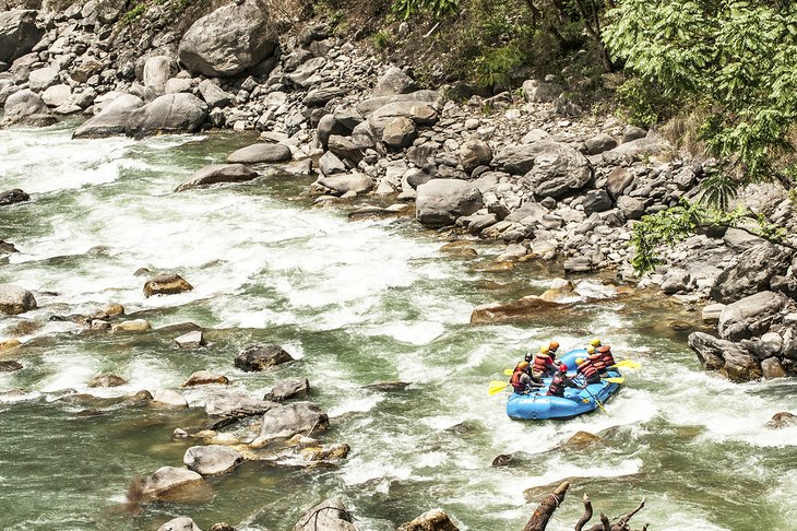
With towering mountains and rushing rivers, Nepal is an excellent place for white water rafting. Several options are available depending on how much time you want to spend on the river.
An easy trip for travelers only looking for a one-day adventure is the Trisuli Rafting Day Trip from Kathmandu. Unlike many rafting trips, which are seasonal, this one is available year-round. After your day of rafting, you can either go back to Kathmandu or on to Chitwan or Pokhara.
If you are looking to spend more time on the water and are interested in more serious rapids, one of the most popular places to go is the Bhote Kosi River.
Bhote Koshi River Rafting trips take two days and are intense. You'll find yourself in the white water shortly after putting in, and along the way, you'll blast through class IV and V rapids. The trip is 25 kilometers long and includes camping on the riverbank for one night. Meals are included.
Other multiday trips to consider are on the Tamur, Karnali, Arun, and Bheri rivers.