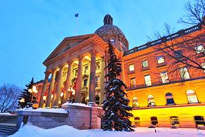
Tourist Attractions in Alberta
Alberta is home to some of Canada's most impressive scenery and five UNESCO World Heritage Sites. This is where the prairies meet the mountains, and spectacular snowcapped peaks dominate the skyline.
The glaciers and turquoise lakes of Banff and Jasper National Parks are the main attractions in summer, drawing millions of tourists each year to the province. These parks are also home to some of Alberta's top ski resorts, offering some of the best skiing in Canada. To the east, the plains and badlands hold important historical and cultural attractions.
The main cities in Alberta are Calgary and Edmonton. Calgary is a modern city with a wealth of things to do. It's most famous for the annual Calgary Stampede. Farther north, the provincial capital of Edmonton is home to West Edmonton Mall, the largest shopping center in Canada, along with numerous other cultural attractions.
A visit to Alberta should definitely be on your western Canada itinerary. For a better understanding of the province and ideas for things to do here, see our guide to the top tourist attractions in Alberta.
Banff National Park
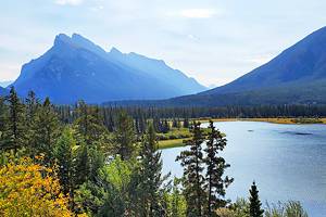
Banff National Park is the most visited tourist attraction in Alberta and arguably the most impressive national park in Canada. Just 130 kilometers west of Calgary, the area encompasses spectacular mountain scenery, major ski resorts, beautiful lakes, and the tourist town of Banff.
Wildlife is abundant here, with grizzly bears, black bears, wolves, caribou, and elk, many of which are frequently sighted along the main highway through the park.
Hiking is one of the main summer activities in Banff, and there are many frontcountry and backcountry trails to choose from. Many people explore the park from the comfort of their car, stopping at the numerous roadside lookouts that offer impressive views over the mountains, lakes, and glaciers.
One of the top attractions in the town of Banff is the Sulphur Mountain Gondola. Take a ride to the top and enjoy the spectacular views out in all directions, made even better by recent renovations and improvements to the building at the top.
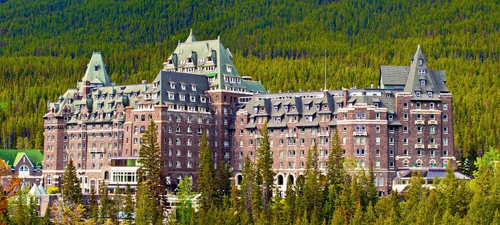
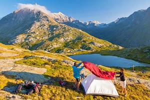
Banff National Park is a large area to explore, and it definitely makes sense to either stay a few nights in a hotel or set up camp in one of the excellent campgrounds in the park. If you prefer something a bit more refined than a nylon tent and a patch of dirt in the trees, consider checking in at the world famous Fairmont Banff Springs Hotel. Dating from 1888, this iconic Banff hotel has been hosting discerning customers for generations.
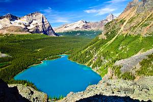
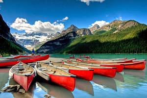
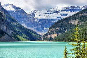
Lake Louise
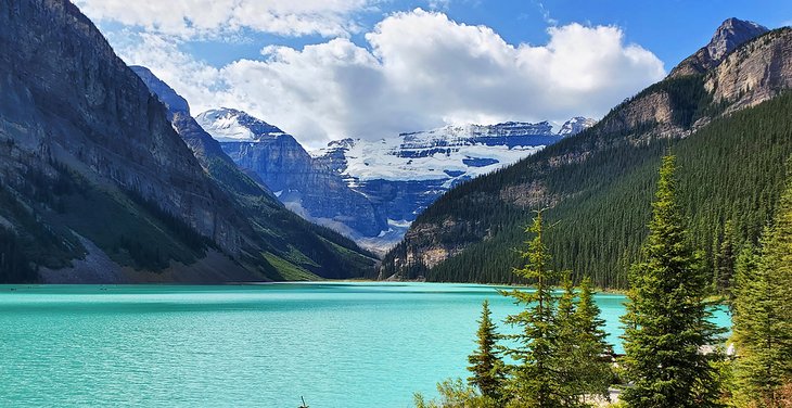
Lake Louise, the jewel of Banff National Park, is famous for its beautiful turquoise colored water that reflects the surrounding mountains and Victoria Glacier. Located just a short drive north of the town of Banff, the lake is an easy day trip from Calgary.
From the grand Fairmont Chateau Lake Louise is a fabulous view across the lake. A walkway runs along the shoreline allowing visitors a lovely place for a leisurely stroll to absorb the atmosphere. Canoe rentals are also available for those who want to paddle out on the lake.
From the lakeside path, there are excellent hiking trails leading either up the mountain or beyond the lake towards the glacier. One of the most popular hiking trails is the hike up to the Lake Agnes Tea House.
In winter, the lake is frozen, and trails are covered deep in snow. Many people come to Lake Louise during this time of year to enjoy the nearby Lake Louise Ski Resort, one of Canada's most popular ski destinations.
Lake Louise Village, just a short distance from the lake, has some tourist-related retail shops, small restaurants, and coffee shops. However, there is not much here beyond the main plaza. Nearby, is a large campground in a lovely natural setting.
During the busy summer months, from May to October, parking is extremely limited. You can take a Roam Transit shuttle from the town of Banff to Lake Louise, or book a Parks Canada Shuttle from the park and ride outside of Lake Louise. These now must be booked in advance, walk-up seat sales are not available. There are several ways to get from Banff to Lake Louise.
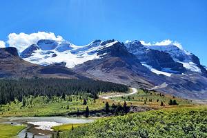
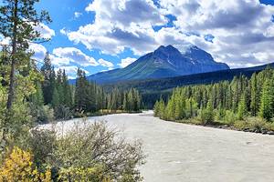
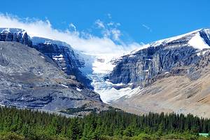
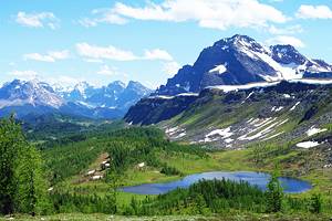
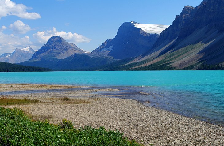
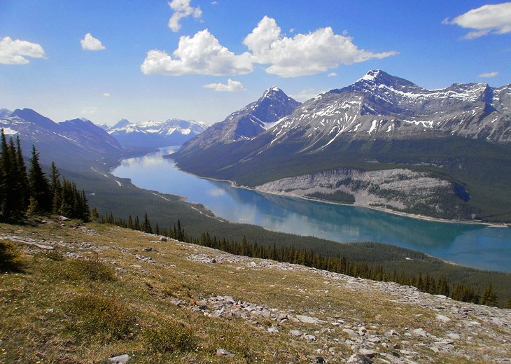
Icefields Parkway and the Columbia Icefield
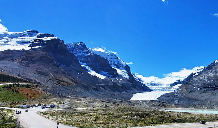
The Icefields Parkway runs from Lake Louise to Jasper and is one of the most beautiful drives in Canada. This 230-kilometer stretch of highway leads past lakes, mountains, glaciers, and waterfalls, with stopping points for visitors to get out and experience the landscape. Numerous hiking trails along the way, most of which are day hikes, lead to scenic lookouts over surrounding glaciers or lakes.
One of the main attractions along the Icefields Parkway is the Icefields Centre. This large visitor's center features excellent displays on the Columbia Icefields and looks out over the Athabasca Glacier. From the road, it is difficult to comprehend the layout and size of the icefields, but models and photos at the center offer a unique perspective.
Across from the center, it's possible to walk up to the toe of the glacier. Alternatively, tours in specially outfitted buses are available, which drive visitors out onto the glacier. One of the newest attractions is the Glacier Skywalk, a huge observation platform standing 280 meters above the valley below, with a glass floor and glass railings. A shuttle service runs from the Icefields Center to the Glacier Skywalk.
To fully explore this area, you'll likely need a few days, and most people stay in nearby Lake Louise. Alternatively, and substantially cheaper, is camping. Along the Icefields Parkway are a number of wonderful campgrounds, some with incredible views and excellent hikes nearby.
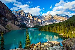
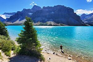
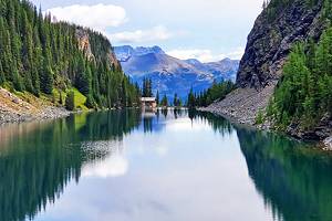
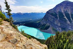
Moraine Lake
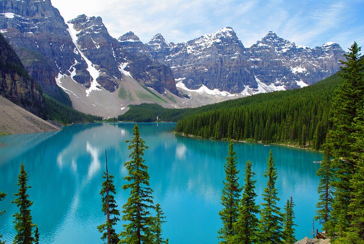
Beyond Lake Louise, at the end of a scenic 13-kilometer-long twisty mountain road, is Moraine Lake in the Valley of the Ten Peaks. Like Lake Louise, this is another scenic setting with similar turquoise water and snow-capped peaks. It was for many years the location of the image on the reverse side of the old Canadian twenty dollar bill and is one of the most popular places to photograph in Canada.
Moraine Lake is surrounded by ten peaks, each more than 3,000 meters high, containing the Wenkchemna Glacier. There is a great view across the lake from an overlook reached by hiking up a short path known as the Rockpile Trail, located near the parking lot. In the spring, the thunder of falling glaciers or landslides can be heard in the distance.
From Moraine Lake, there is a day hike to Larch Valley and Sentinel Pass, one of the best hikes in Banff National Park. It is a somewhat exhausting day hike, but the reward is the stunning view back towards the lake and down into Paradise Valley. This hike is often snow covered in the upper region even into July. The area is particularly beautiful in autumn when the larches are changing color. The hike to the Sentinel Pass (elevation 2,611 meters) involves climbing a total of six kilometers and ascending 520 meters.
Like Lake Louise, Moraine Lake is an extremely popular area, and parking will likely be unavailable if you arrive in your own vehicle between spring and fall. The Parks Canada Shuttle from the Park and Ride outside Lake Louise is the best option for visiting the lake.
Waterton Lakes National Park (Waterton-Glacier International Peace Park)
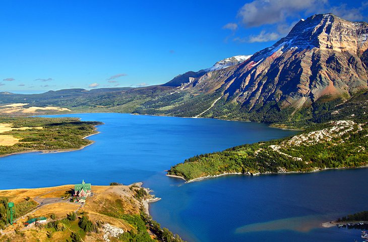
The Waterton-Glacier International Peace Park in the Rocky Mountains straddles the border between Alberta and the U.S. state of Montana. On the Canadian side of the border is Waterton Lakes National Park, while on the American side is Glacier National Park.
Waterton Lakes is the smaller of the two parks but features some fantastic scenery with mountains and Waterton Lake. Overlooking the lake, from a fabulous position on the north shore is the Prince of Wales Hotel, a National Historic Site of Canada. Nearby, is the town site with tourist amenities. Many people come to the park to hike on the alpine trails, camp, or take a sightseeing tour.
Official site: https://www.pc.gc.ca/en/pn-np/ab/waterton/index
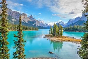
Jasper National Park
Much like Banff, the name Jasper is associated with both the national park and the town of Jasper, which lies at the heart of this stunning park. Jasper is the biggest national park in Canada, covering an area of 10,878 square kilometers. It is an area of lakes, waterfalls, mountains, glaciers, and forests, but has a slightly different appearance than the parks and natural areas farther south.
Both the park and the town of Jasper are less visited than Banff and have a more remote feel, particularly in winter when many facilities in the area are closed. Unlike Banff, the town of Jasper sees very few tourists outside of the peak summer season giving it a much more seasonal character.
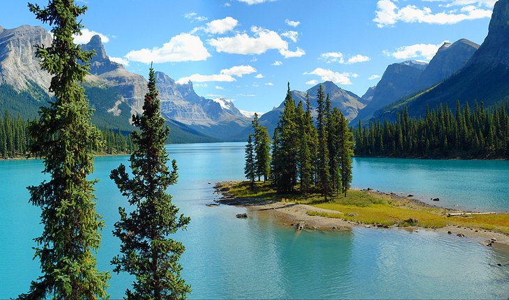
Some of the key highlights in Jasper National Park are Maligne Lake, which is frequently pictured in advertisements for the Canadian Rockies, Mount Edith Cavell with the stunning Angel Glacier, and Maligne Canyon. Hiking trails and scenic lookouts can be found throughout the park. In winter, locals enjoy the Marmot Basin Ski Resort.
Official site: https://www.pc.gc.ca/en/pn-np/ab/jasper/index
Read More:
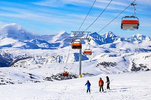
Lake Louise Ski Resort
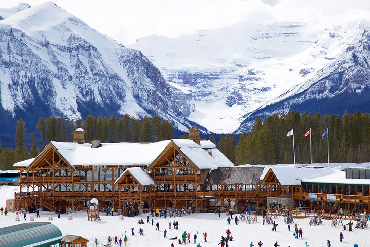
Lake Louise Ski Resort is one of the best ski resorts in Canada and is known around the world as a stop on the World Cup of skiing. Home to 164 named runs, plus a few through the trees that only locals know about, this ski hill has something for everyone.
Lake Louise Ski Resort is a popular family ski vacation destination for its well-regarded ski school, varied terrain, and good facilities. The resort is only a couple of hours from Calgary International Airport, making it easy to get to from destinations near and far.
Skiers take note: the resort has made significant investments in infrastructure over the past two years that include a new lift opening up the West Bowl area and a new quad chair at the base area to alleviate the morning crush.
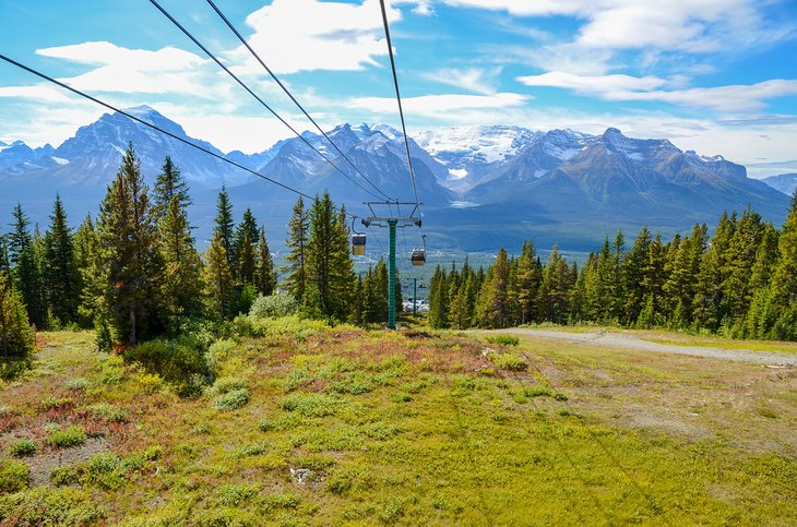
In the summer, the ski resort operates its gondola. In mere minutes, it will whisk you to the top of the mountain where you'll enjoy spectacular views out to the surrounding mountains and across the valley to Lake Louise. If you are lucky, you may spot a grizzly bear on the way up; they enjoy grazing in the open grassy areas where the ski runs are in the winter.
Official site: https://www.skilouise.com/
Sunshine Village Ski Resort
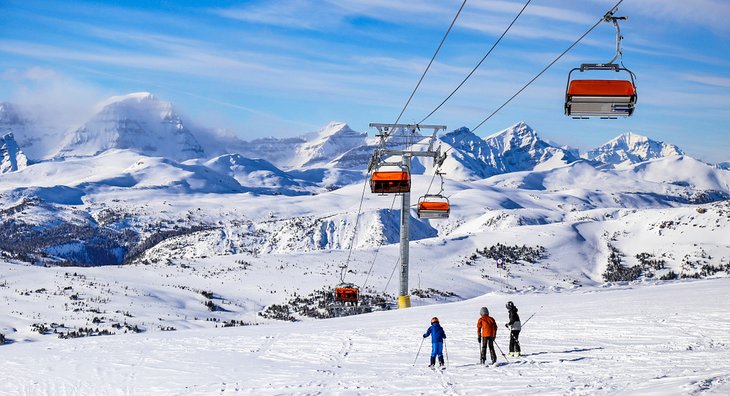
Sunshine Village, located just outside the town of Banff, is one of Alberta's most popular ski resorts, but it is also a beautiful area for hiking and walking in summer. In winter, the mountain, which offers a good mix of intermediate and advanced runs, attracts skiers from all over the world. It's one of the best ski resorts in Canada and one of the best ski resorts in Alberta.

In summer, following the snowmelt, the area is open to hikers. Take the gondola from the base of the mountain to the Village terminal to explore Sunshine Meadows. From here, trails of varying lengths lead into the mountains. Hike on your own or join a guided hike.
Official site: http://www.skibanff.com/
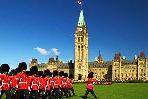
Calgary Stampede
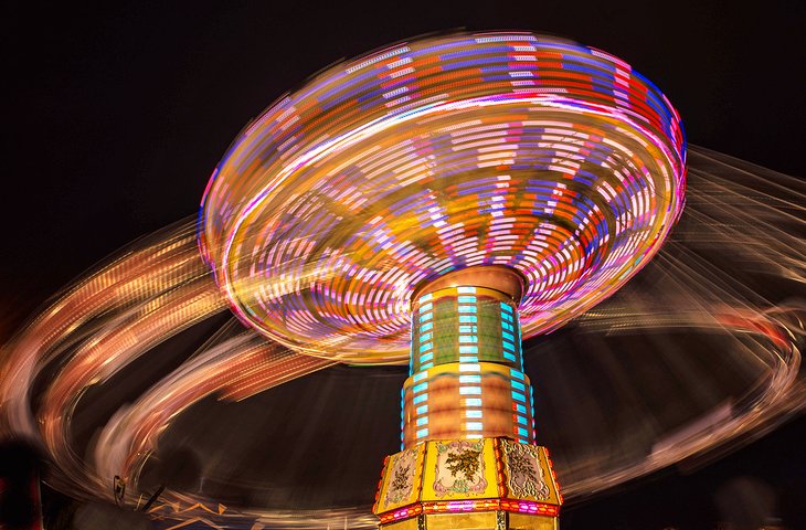
Calgary takes particular pride in its cowboy roots. This becomes most apparent during the city's biggest event, the annual Calgary Stampede. This is a ten-day event held in early July, drawing rodeo participants and over 1 million fans from across North America. Calgary becomes the center of attention for all Wild West fans, with rodeo attractions, cultural exhibits, country music, and a range of other outdoor spectacles.
In addition to what goes on at the Stampede Grounds, local establishments around Calgary also participate in the festivities by offering free "Stampede breakfasts" throughout the week. Stores decorate their windows, cowboy hats and boots become the primary fashion, and temporary petting zoos and midway rides pop up in parking lots.
Official site: http://www.calgarystampede.com/
Read More: Attractions & Places to Visit in Calgary
Drumheller and the Royal Tyrrell Museum of Paleontology
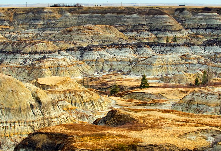
Located approximately 140 kilometers northeast of Calgary is the small town of Drumheller, which proudly calls itself the "Town of the Dinosaurs." Around 75 million years ago, various species of dinosaurs inhabited this region, and many fossils have been discovered in and around Drumheller. The Royal Tyrrell Museum of Paleontology displays some of the finds and offers an in-depth look at the history of the area.
The landscape around Drumheller consists mainly of badlands. Interesting hiking trails lead past hoodoos and through unique rock formations. The "Dinosaur Trail" is a driving tour that leads through some of the area's main attractions.
- Read More: Tourist Attractions in Drumheller
Kananaskis Country
About 80 kilometers west of Calgary is a beautiful area known as Kananaskis Country. This is a favorite spot for hikers in the summer with trails that lead to peaks, meadows, and lakes. Kananaskis Village has resort facilities and a popular golf course.
Kananaskis Country has an amazing collection of wonderful campsites. You'll generally find them set among pine trees and near crystal-clear lakes or rivers. They are popular in the high season, so be sure to book well in advance.
Peter Lougheed Provincial Park is one of the main highlights of Kananaskis, particularly for those who want to spend some time immersed in nature. The park forms the very heart of the Kananaskis region where elk, bighorn sheep, mountain-goats, grizzly bears, and black bears roam free.
The park covers 508 square kilometers, which makes it the largest provincial park in Alberta. In summer, locals and visitors are attracted here by the superb mountain scenery, traversed by various trails and dotted with alpine lakes.
Official site: http://www.albertaparks.ca/kananaskis-country.aspx
West Edmonton Mall
The West Edmonton Mall is more than just shops. Contained within this huge complex is the World Waterpark, the Ice Palace ice rink, mini golf, an aquarium with live shows, a bowling alley, a mirror maze, indoor electric go-kart racing, and movie theaters. Of course shopping is important, too. The mall has all kinds of stores for everything you could imagine.
The mall is a destination within Alberta, particularly in winter, where families can come to escape the cold and enjoy some indoor fun and shopping.
Official site: http://www.wem.ca
Read More: Tourist Attractions in Edmonton
Calgary Tower
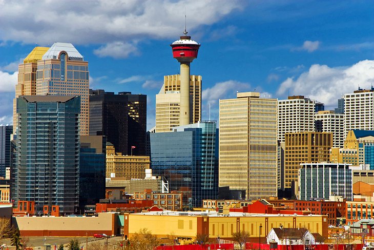
The Calgary Tower is one of the prime tourist attractions in Calgary. Standing tall on the city skyline, the tower offers the highest 360-degree observation deck in the world. On clear days, there are outstanding views to the mountains, and on any day, the glass floor offers a direct view down over the city. Depending on the event or celebration, the Calgary Tower will light its massive torch mounted on the very top.
The Sky 360 is a revolving restaurant located at an elevation of 155 meters, and directly above this is Ruth's Chris Steakhouse.
Official site: http://www.calgarytower.com/
Canmore
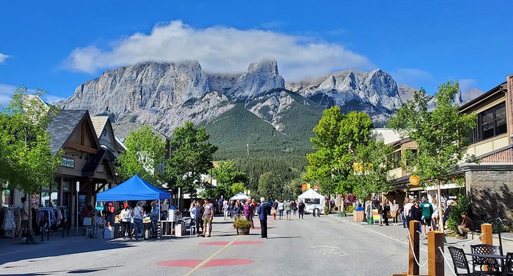
Just outside the entrance to Banff National Park, Canmore is a lively small town with restaurants, shops, and services. This growing community attracts people who are interested in enjoying a mountain lifestyle. In the surrounding area are hiking and mountain biking trails, and Alberta's best ski resorts are just a short drive away. Calgarians use the town as an escape, and many have second homes or condos here. Some people prefer to camp in one of the fine campgrounds nearby.
For visitors, one of the key attractions are the Canmore Cave Tours. These tours last about 4.5 hours and take you to Rats Nest Cave, known for being one of the longest in Canada.
If you are interested in hiking trails, the hike to Grassi Lakes is one of the most popular and it's relatively easy. The trail was closed and significantly upgraded in summer 2022, the new improvements are expected to make this already amazing hike even better.
You can also base yourself in Canmore and explore the hiking trails in nearby Banff National Park and Kananaskis Country.
Wood Buffalo National Park
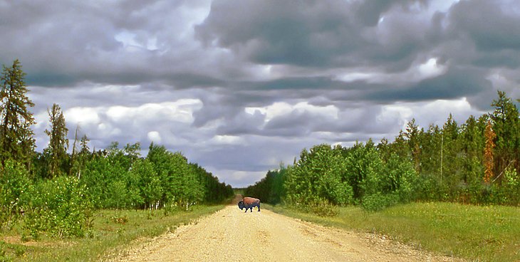
Wood Buffalo National Park is the largest park in Canada and a UNESCO World Heritage Site. Due to its remote location on the border of Alberta and the Northwest Territories, the park sees fewer visitors but holds a number of treasures.
Wood Buffalo extends across the Athabasca-Peace River Delta, one of the largest inland deltas in the world, but the main attraction here is the wildlife, including the park's wood bison. The park was established in 1922 to protect the last herds of these beautiful animals, often called wood buffalo, which now thrive here. Moose, black bear, caribou, and beaver also call the park home, and whooping cranes breed here.
While most people visit in the summer, the park is open all year, and you can find an assortment of winter activities. Wood Buffalo National Park is a dark-sky preserve, making it a good place to see the northern lights in winter.
- Read More: Exploring Wood Buffalo National Park
Head-Smashed-In Buffalo Jump
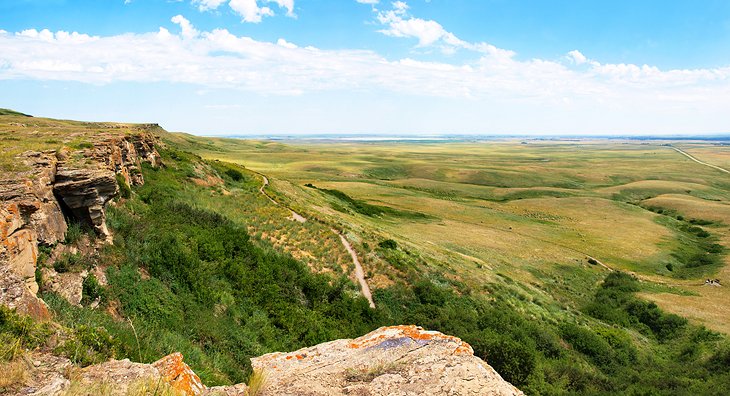
On the edge of the prairies, a rise in the landscape terminates at the edge of a cliff. For thousands of years, indigenous peoples in the area used this natural feature to drive herds of buffalo over the edge.
The 11-meter fall would break their legs and injure them enough for the Blackfoot hunters to move in and kill them. The bodies were then processed and used for food and other purposes. Buffalo jumps were also used in other areas of the plains but this site is the largest, oldest, and best preserved in North America.
The area is today a UNESCO World Heritage Site. The Head-Smashed-In Buffalo Jump Interpretive Center offers detailed information on the site and the Plains Buffalo culture.
Official site: https://headsmashedin.ca/