Tourist Attractions in Bolzano
Often overlooked by travelers whizzing past on the highway en route to Lake Garda and Verona, Bolzano deserves more notice. The unique history of this Sudtirol region gives it a curious - but quite pleasant - blend of Italian and Germanic cultures.
You'll notice this in the street names, architecture, food, and language. Signs tend to be bilingual, and you'll hear as much German in cafés as you do Italian. The Christmas market that fills Piazza Walther each December could be anywhere in Bavaria, filled with alpine wood carvings, gingerbread, and Germanic holiday traditions.
In addition to its own sights, Bolzano is worth visiting as the western gateway to the spectacular Dolomite Road, acclaimed by UNESCO as a World Heritage Site. Discover the best places to visit and things to do in this picturesque alpine town with our list of the top tourist attractions in Bolzano.
Museo Archeologico dell'Alto Adige
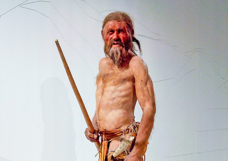
If you pass through Bolzano and see nothing else, do stop to see Ötzi, the astonishing Ice Man at the archaeology museum. No other place in the world can you look at a man who has been preserved in ice for 5,300 years, and see his clothing and equipment, frozen with him deep inside a glacier.
"Frozen Fritz" is shown as part of a fascinating and well-designed exhibit of prehistoric inhabitants in the Dolomites. Ötzi and his possessions, life, and times are not the only subjects covered in the museum; it documents the region from the Paleolithic to the pre-medieval periods.
Address: Via Museo 43, Bolzano
Official site: www.iceman.it
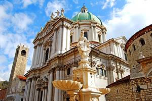
Cathedral
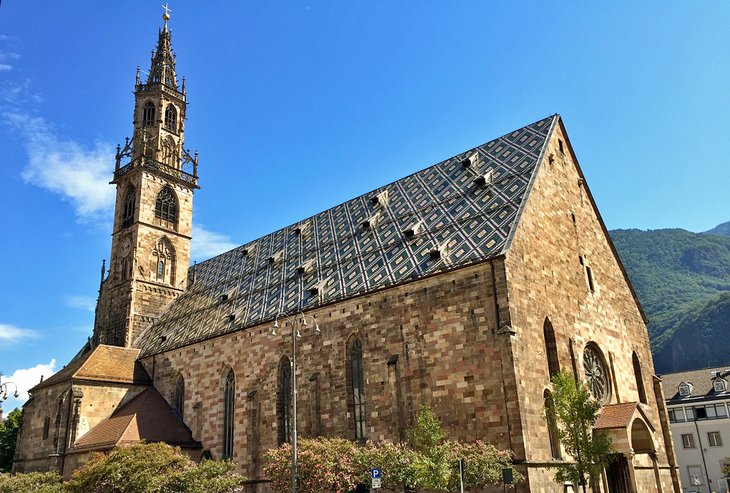
At the southwest corner of the square is the Gothic parish church (14th-15th centuries), which is also the cathedral. It has an elegant spire, 65 meters tall, of open filigree carved in sandstone, built from 1504 to 1519 and extending from a striking roof of patterned tiles.
Walk around the church to see its doorways - a Romanesque portal with lions supporting columns (and the 1475 fresco of the Madonna); a beautiful bronze door; and on the north side, the engraved Wine Door. This is one of the finest High Gothic portals in the Tyrol.
In the interior is a Gothic pulpit carved of sandstone and supported by a single pillar, a Baroque polychrome marble altar, and a Baroque chapel with 18th-century frescoes. Elsewhere are frescoes from the 14th and 15th centuries. The treasury is worth visiting for its beautiful examples of 18th-century gold work and sacred art, especially the gold monstrance of the cathedral bell tower, 136 centimeters tall.
Address: Piazza della Parrocchia 27, Bolzano
Dominican Church and St. John's Chapel
The Gothic Dominican church was built in the 13th century - one of the first Gothic buildings in the Sudtirol - and remodeled in 1498 to give it the present three naves. There are fine late 14th-century frescoes on the west wall of the church, and in the cloister are frescoes by Friedrich Pacher that date from 1496.
The altarpiece is from 1655. However, the Cappella di San Giovanni (Chapel of St. John) has the real artistic treasure, a magnificent fresco cycle of the Giotto School, definitely the finest in the Sudtirol. Look especially for the Triumph over Death and the Escape to Egypt frescoes. The chapel itself dates to 1180.
Address: Piazza Domenicani, Bolzano
Renon Cable Car
One of the favorite things to do in Bolzano is ride the Renon Cable car from Bolzano to the plateau of Soprabolzano (Oberbozen in German). In just 12 minutes, the 4560-meter cableway, which opened in 2009, rises 950 meters with views of the city giving way to panoramic views of the Dolomites.
Gondolas leave every four minutes and hold 30 passengers, so even at busy times there is very little wait. You can also take bikes or strollers on board. On arriving in Soprabolzano, follow signs for the Freud-Promenade, a walking path punctuated by quotes from Sigmund Freud. The base station for the cable car is about a 10-minute walk from Bolzano's Piazza Walther.
Address: Via Renon 12, Bolzano
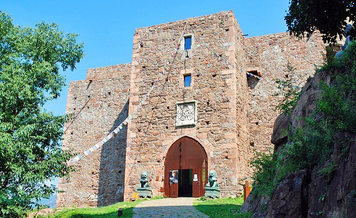
Castel Roncolo
High on a precipitous crag just outside Bolzano, the 13th-century Roncolo castle, also known by its German name of Runkelstein, contains an astonishing treasury of 14th- and 15th-century frescoes. Unlike most that survive from that era, the Roncolo frescoes depict not religious subjects, but scenes of everyday court life.
Men hunt and take part in chivalric competitions, and ladies watch from galleries, providing a glimpse into life in a medieval castle and the dress of the times. Other frescoes make literary references to stories of King Arthur or Tristan and Isolde. They are in remarkably good condition and constitute the largest and best preserved collection of medieval non-religious frescoes surviving today. Getting to the castle is easy via the free buses from Piazza Walther.
Address: SS 508, Bolzano
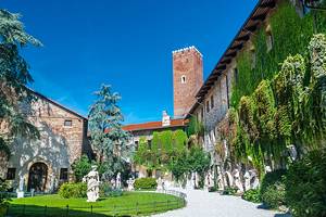
Messner Mountain Museum
The halls, courtyards, and even turrets of Firmian Castle are filled with exhibits, art, and relics that bring the surrounding peaks to life. Mountaineer Reinhold Messner's collections present a fully rounded picture of the relationship between the Dolomites and the people who have lived among them and attempted to conquer them.
The museum follows the history of mountaineering, the Dolomites' natural history, and the influences of the mountains on religion and culture from the earliest ascents into modern alpine tourism.
Address: Sigmundskronerstr 53, Bolzano
Official site: www.messner-mountain-museum.it
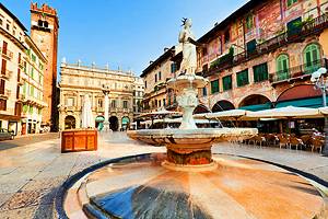
Piazza Walther and Via dei Portici
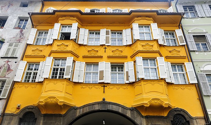
The central square of Bolzano is the Piazza Walther (Waltherplatz), a broad open space where markets and festivals are held, notably the annual Christmas market in December. To the north is the arcaded Via dei Portici (Laubengasse), the town's principal shopping street, with fine 17th-century town houses.
Palazzo Mercantile (1708-27), now the Chamber of Commerce, on the south side of the street, is the only example of an Italian palazzo in Bolzano. At the west end of Via dei Portici is the fruit market, Piazza delle Erbe, with a Neptune Fountain. In a small square at the east end stands the Town Hall, a building in Baroque style erected in 1907. The surrounding streets are filled with buildings of various architectural styles, some with painted facades.
Franciscan Monastery
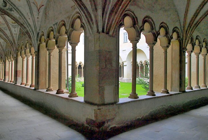
A little way north of Piazza delle Erbe stands the Franciscan monastery. Its church dates to the late 1300s and has a vaulted ceiling from the 15th century and 20th-century stained-glass windows. In the Lady Chapel is a fine Late Gothic altar of carved and painted wood by Hans Klocker, from about 1500.
In the adjoining 14th-century Gothic cloisters are frescoes of various ages, while the St. Erhard chapel displays a cycle of early Gothic frescoes from the 14th century.
Address: Via Francescani 1, Bolzano
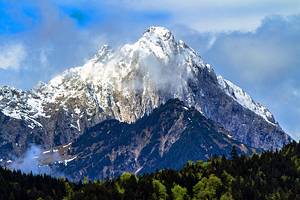
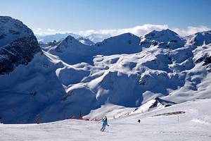
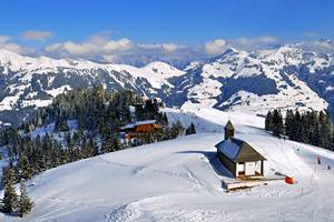
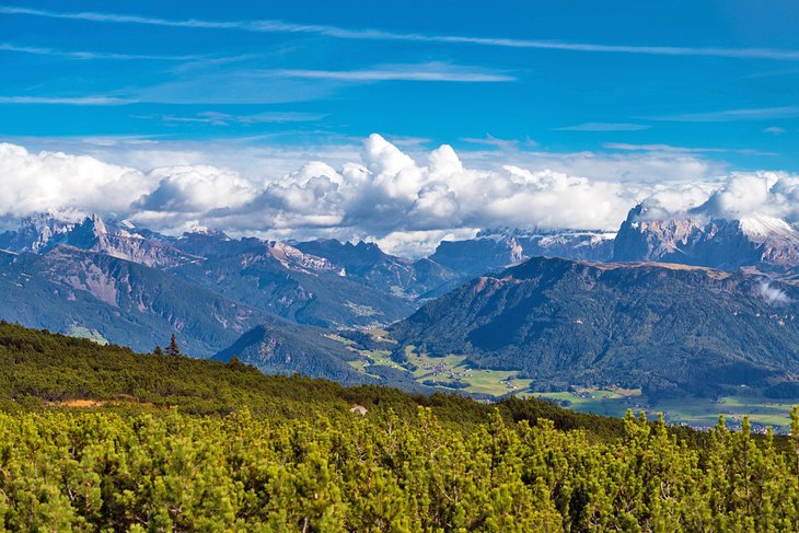
Dolomite Road (Strada delle Dolomiti) Day Trip
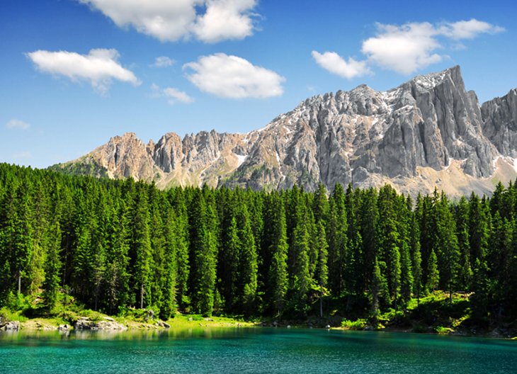
Bolzano is the western end of one of Europe's most spectacular driving routes, cited by UNESCO as a World Heritage Site for "some of the most beautiful mountain landscapes anywhere, with vertical walls, sheer cliffs, and a high density of narrow, deep, and long valleys."
Along with the beauty of the glacial landscapes, UNESCO cited the geologic importance and fossil records of the 18 majestic snowcapped peaks. The beauty of this route between Bolzano and the Olympic ski resort town of Cortina D'Ampezzo is that it is easy to tour by car, without the terrifying turns and precipitous overhangs of many mountain routes.
More adventurous drivers can explore the several side valleys that radiate from the route to find timeless alpine villages and more views. Several of the lifts that take skiers to the high snowfields during winter also carry tourists in the summer.
The combination of spectacular mountain peaks, outdoor recreation, and quaint Alpine villages makes this one of northern Italy's most popular places to visit, and you can easily see the best of it on a day trip from Bolzano.
Naturmuseum Sudtirol
Families with children and those especially interested in the wildlife and geology of the Sudtirol region should visit this small museum. Permanent exhibits explain the formation of the Dolomites from the reefs of the warm seas in the Triassic Age.
As the western Dolomites have not been subject to folding, this is the only place in the world where scientists can study fossil reef structures. Other permanent exhibits include a 9.000-liter coral reef aquarium, freshwater aquariums and a number of interactive exhibits designed for children; all ages are fascinated watching ants at work in the large ant farm.
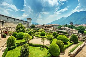
Castel Trauttmansdorff Gardens
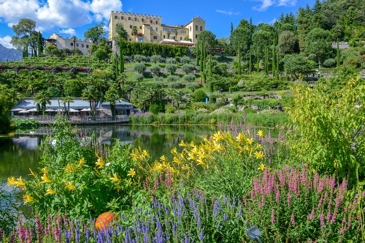
In the spa town of Merano, northwest of Bolzano and worth a stop to stroll beneath the medieval arcades of its 800-year-old shopping street, is Trauttmansdorff Castle, known for its beautiful flower gardens.
More than 80 garden landscapes include "Forests of the World" with North American and East Asian conifers, ferns, and rice and tea terraces. "Sun Gardens" explores the Mediterranean with citrus trees and fragrant herbs. An English cottage with its garden, a maze, Renaissance gardens, and water gardens are among the places to visit in this botanical trip around the world.
Merano is a good day-trip from Bolzano, with plenty of things to do.
Address: Via S. Valentino 51a, Merano
Official site: www.trauttmansdorff.it
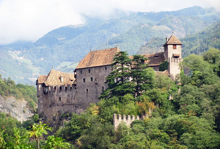
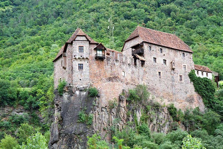
Castel Tirolo
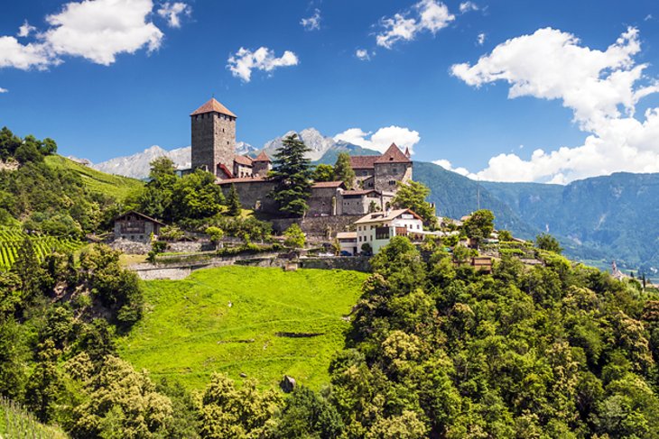
From the Porta Passiria in Merano, a four-kilometer road follows the Gilf Gorge past Castello San Zeno (12th and 13th centuries) and up the slopes of Monte Benedetto to the village of Tirolo. From here, it is a 25-minute walk, passing above Castel Fontana and through a narrow gorge to the 12th-century Castel Tirolo (Schloss Tirol).
In the 12th and 13th centuries, the castle was the residence of the counts of Tirol, the origin of the name for the whole region of Tirol (Tyrol). The circular wall, built around AD 1100, is one of the oldest preserved circular walls remaining anywhere.
The castle now houses the Regional Museum covering the area's history, everyday life in the Middle Ages, and the castle's own story. The most fascinating series of exhibits is a timeline of events in this region's tumultuous history, divided into five- or six-year segments. Photos and artifacts are arranged so that each period is on a different level, a few steps higher as you climb the large tower.
Address: Via Castello 24, Merano
Official site: www.schlosstirol.it
Monumento della Vittoria (Victory Monument)
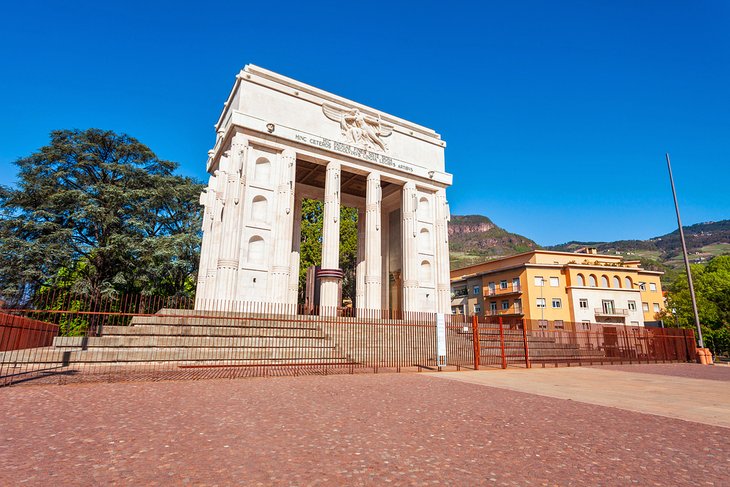
Via Museo leads across the Talvera Bridge, to a large triumphal arch, the Victory Monument, erected in 1928 at the personal directive of Mussolini to underscore the annexation of the Sudtirol (South Tyrol) by Italy after World War I.
Although dedicated to "Martyrs of World War I," the message in its fascist symbolism and inscription was provocative to the German-speaking population, and it is still controversial today (which accounts for the fence around it). Behind the monument is a park and Piazza Vittoria, where you'll see more monumental buildings in Rationalist style. A large market fills the square on Saturdays.
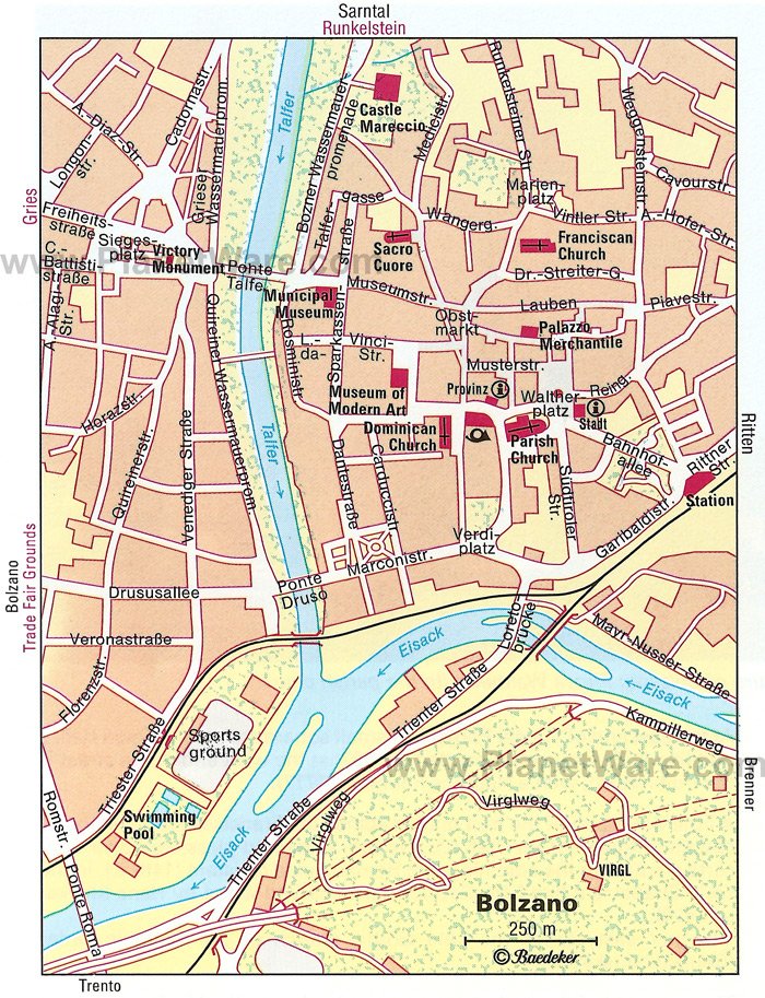
Map of Tourist Attractions & Things to Do in Bolzano
More Related Articles on PlanetWare.com
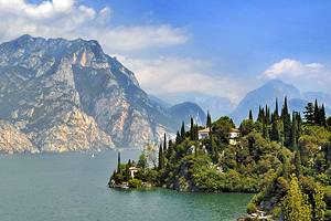
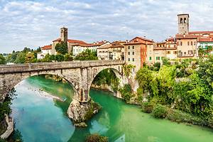
Places to Visit near Bolzano: Heading south from Bolzano through the Alto Adige region, you'll come to the often overlooked but historic city of Trento, site of the 16th-century Council of Trent. Beyond lies one of Italy's favorite playgrounds, which you can learn about in our article on the top attractions around Lake Garda.
Places to Visit near Bolzano for Skiers: A day trip into the Dolomites may make you long to return to Bolzano in the winter to sample the skiing, since Cortina d'Ampezzo and several other ski resorts in Italy are within easy reach. Only three hours north is Innsbruck, from which you can reach several of the top ski resorts in Austria.