Attractions & Places to Visit in Utah
Utah is one of the nation's great outdoor states, with fabulous ski resorts, incredible national and state parks, and natural wonders like you won't find anywhere else in the world. It's also home to lively cities and interesting towns to explore.

The state's big national parks, the "Mighty Five" are always a good place to start. A road trip through Utah is one of the best ways to see the sights, and scenic drives are everywhere throughout the state. For cultural highlights or skiing, head to Salt Lake City. If you're looking for adventures, from hiking, mountain biking, and camping to ATV motorcycle riding and off-road pursuits, be sure to spend some time around the cities of Moab and St. George. You'll even find lakes in Utah where you can bask on a beach or enjoy a boat ride.
Keep in mind, Utah's elevation varies considerably, and while it's hot and sunny in some areas, it may be snowing in others. Some parks have only limited accessibility in winter, and some towns almost shut down during this season, but most of the best places to visit are open year-round. For more ideas, see our guide to the top attractions in Utah.
Zion National Park
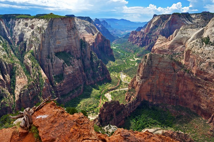
Zion National Park, less than a three-hour drive from Las Vegas, features some of Utah's most outstanding scenery. Red rock cliffs, waterfalls, and stunning vistas are some of the key attractions.
Many of the park's most impressive sites are found in Zion Canyon, along the Zion Canyon Scenic Drive, which follows the valley floor. From spring until fall, a sightseeing bus takes visitors through the park along this route, stopping at all the major sites and trailheads. This makes touring the park very simple. In winter, you can drive this route in your own vehicle.
The Zion-Mount Carmel Highway runs east-west through the park and is also a must-do drive. This self-drive route takes you high above the valley and offers incredible views from the lookouts.
Sometimes referred to as a vertical park due to its sheer vertical walls, Zion is a hiker's paradise. The most popular hikes in Zion are accessed off the Zion Canyon Scenic Drive and the Zion-Mount Carmel Highway. Here, you'll find everything from simple walks along the valley floor to cliff-side trails, like the famous Angel's Landing trail, which is not for the faint of heart or anyone with a fear of heights.
If you are here to truly experience the outdoors, you'll find quality campgrounds and RV parks in and near Zion National Park.
Although this is an extremely busy park, it does not have timed entries or require advanced bookings to enter.
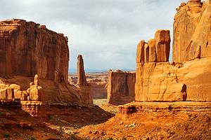
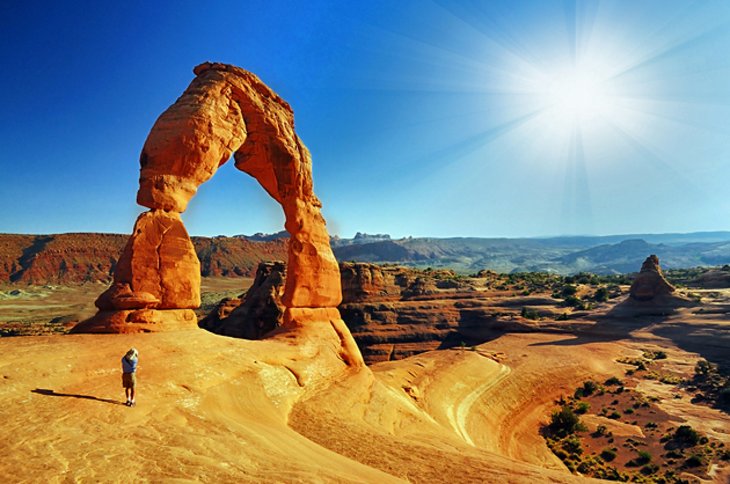
Arches National Park

Stunning stone arches and rolling petrified dunes, backed by the often snow-capped peaks of the La Sal Mountains, make this one of the most scenic parks in Utah. Arches National Park is home to more than 2,000 natural stone arches. The most famous of these, and the most photographed, is Delicate Arch, standing like a horseshoe jutting out of the ground, framing the distant mountains.
Numerous walking trails and hikes lead to the most popular arches and other interesting rock formations. But many of the main highlights can be seen right from the scenic drives through the park and easily accessed from the parking areas.
The best places to visit in the park are Devil's Garden, Delicate Arch, Fiery Furnace, Double Arch, Park Avenue, Balanced Rock, the Windows, Broken Arch, and Sandstone Arch.
Arches National Park does have timed entries from April to October and you need to book these in advance. You can book your time up to three months in advance.
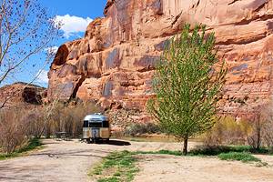
Arches National Park is located just outside Moab, a town well-known by mountain bikers and outdoor adventurers. The park is considerably higher than the town and is reached via a winding road with impressive views. You'll find several other scenic parks in the vicinity and a variety of good campgrounds in the area.
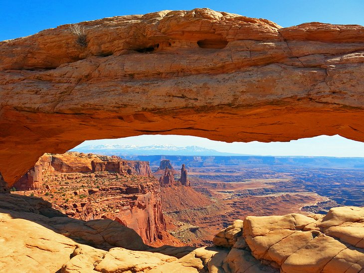
Canyonlands National Park

Canyonlands National Park is Utah's version of the Grand Canyon, without the crowds. The park has three sections, but the main portion, which attracts the majority of sightseers, is Island in the Sky. This area offers incredible vistas looking out over carved canyons and beyond to the snow-capped mountains. It is arguably as impressive as the Grand Canyon in its own unique way, and far less visited.
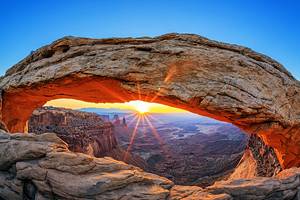
One of the main attractions in Island in the Sky is Mesa Arch. This beautiful stone arch, particularly stunning in the early morning hours or late afternoon, forms a window to the canyons, buttes, and torn landscape below.
Also of note in this section is the White Rim Road, which runs down from the park to the valley below, following a dirt road of switchbacks along sheer cliff walls. This road is only for the brave. Visitors can catch a glimpse of the White Rim Road, across the road from the Island in the Sky Visitors Center.
Canyonlands' Island in the Sky section is located not far from the town of Moab. The main access point is reached by heading north along Highway 191, beyond Arches National Park. The Needles District is located in the opposite direction, off Highway 191 heading south from Moab and takes about two hours to reach.
The other two sections of the park, the Needles District and The Maze, offer a slightly different type of landscape but are also impressive. These areas are more remote. The Needles area is one of the best places for hiking in the park, and The Maze is a popular place for 4x4 road trips.
Canyonlands National Park does not have timed entries but the Island in the Sky district is often busy and parking lots are small at some of the lookouts and can fill up quickly. It's best to try to avoid peak times and arrive early in this area if you can. The park is working on expanding some parking areas.
Bryce Canyon National Park
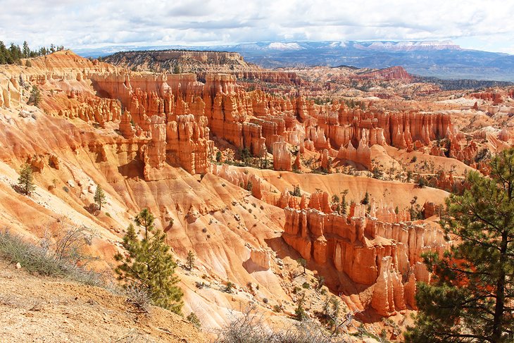
The brightly colored and tightly packed hoodoos that dominate the landscape at Bryce Canyon are what set this national park apart from the rest of the spectacular sites in Utah. Stone pillars, glowing in shades of orange, pink, cream, and cinnamon jut up from the floor of a huge natural amphitheater, creating a magical landscape that almost begs to be explored.
A scenic drive runs through the park and provides numerous lookouts all along the canyon. However, it's worth venturing down into the forest of hoodoos on one of the numerous hiking trails in the park to fully appreciate the size and unique shapes of these formations. Bristlecone pine trees are another surprise attraction found in Bryce.

Bryce Canyon National Park is located at an elevation of 8,000 to over 9,000 feet and receives snowfall during the winter months and into spring. Temperatures up here, even in summer, can be cool to very cold. The best time to visit is from April to October, particularly if you are planning on staying at one of the campgrounds in the area.
This park might feel like it's a long way from anywhere, but there are several options for visiting Bryce Canyon from Las Vegas.
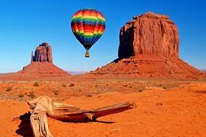
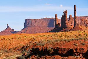
Monument Valley
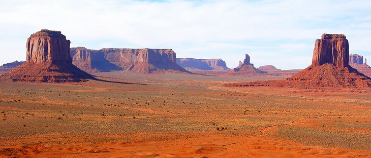
Like a scene from an old western film, red rock buttes rise up from the orange desert floor, and occasionally a horse and rider even wanders by. This is Monument Valley Navajo Tribal Park, located on the Navajo Indian Reservation on the Utah-Arizona border.
Most of the Tribal Park is in Arizona but if you are arriving from Utah one of your first good views of Monument Valley is from Forrest Gump Point. This is a free pull-off area on the road where a scene from Forrest Gump was shot and where now, vendors are often set up.

Numerous films and commercials have been shot in Monument Valley, which is famous for its spectacular red mesas and stone pinnacles. Within the park is Valley Drive, a one-way, 17-mile, self-drive dirt road running between the buttes and through the dramatic landscape. Pullouts all along the route offer great opportunities for photography and soaking up the scenery. This road is not open to RVs or trailers.
If you want to go beyond this one road to explore the park more fully, you must use a guide, which can be arranged at the visitor center. If you don't have time for the drive, which is usually done at a snail's pace due to the curves and sightseeing stops, the view from the Monument Valley Visitor Center is spectacular, and one of the best viewpoints in Monument Valley.
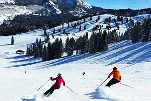
Utah's Ski Resorts
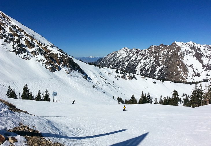
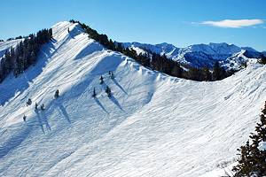
If you're a skier and haven't been to Utah, it's time to go. While other states like Colorado and California tend to steal the spotlight, Utah has some fantastic ski resorts.
Utah gets a surprisingly large amount of snow every year, and the snow that does fall is light and fluffy, making powder days especially amazing. Fun fact: The largest ski resort in the United States, Park City, is located in Utah.
Many of the best resorts are located within an hour of Salt Lake City, either in the Little Cottonwood Canyon, where you'll find Snowbird and Alta; or Big Cottonwood Canyon, where Solitude and Brighton call home; or up by the town of Park City, where Deer Valley and Park City Resort are located. Other popular ski resorts in Utah are Snowbird, Alta, Snowbasin, Sundance, and Powder Mountain.
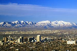
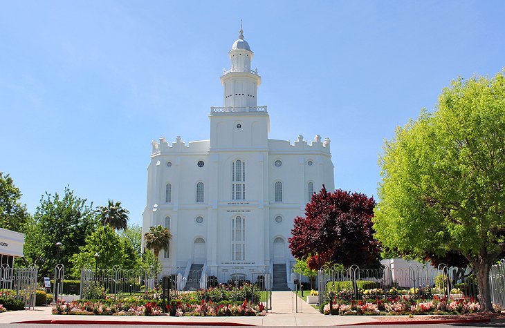
Salt Lake City Temple
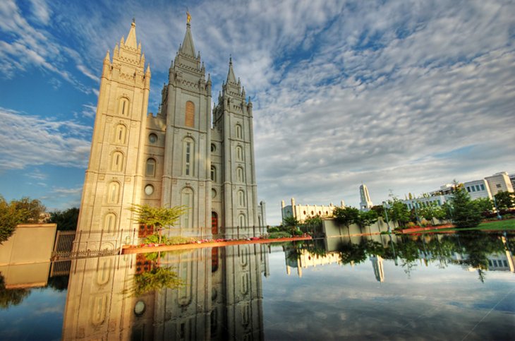
Salt Lake City is often associated with skiing and winter activities, and certainly, many of the best ski resorts in the state can be reached within an hour's drive of here. But this is a city worth visiting, regardless of the season, and offers numerous attractions and things to do.
Standing on Temple Square is the late 19th-century Temple, the largest Church of Jesus Christ of Latter-day Saints and one of Salt Lake City's principal sites. The temple may only be entered by church members, but it is definitely worth walking by to have a look. Another site in the area worth checking out is the Salt Lake Tabernacle.
The entire complex is in the midst of a massive multi-year renovation and revitalization, with different buildings under construction at different times. Be sure to check to see what is open before visiting to avoid disappointment.
Park City
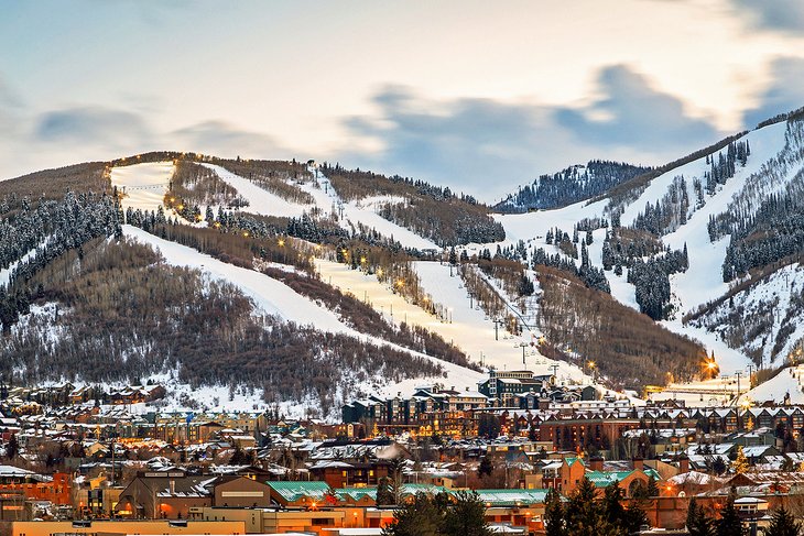
Park City is a fun mountain town, about 45 minutes southeast of Salt Lake City, and home to some of Utah's best ski resorts. Park City is an actual historical town not something artificially created for the skiing crowd. As a result, you'll find an authentic main street with buildings, now full of restaurants and shops, dating from the town's mining days.
One of Park City's most famous events, the annual Sundance Film Festival, is held in late January. At this time, the town is buzzing with creative energy, and regular celebrity sightings are the norm.
On the town's doorstep is Park City Mountain Resort, with lifts operating right from town, and just down the road is Deer Valley Resort, one of Utah's poshest ski resorts. Both of these offer outstanding terrain for all levels of skiers.
Utah Olympic Park, also located in the vicinity, was used as a venue for the 2002 Winter Olympics. Today, it offers year-round activities for kids and adults, from ziplining and hiking in summer to bobsledding in winter.
- Read More: Attractions & Things to Do in Park City, UT
Moab
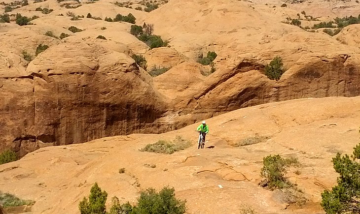
For outdoor adventures in the Southwest, it's hard to beat the town of Moab. As the closest community to Arches National Park, Canyonlands National Park, and Dead Horse Point State Park, this area offers endless opportunities for hiking, biking, rafting, off-road adventures, and more. The rolling petrified dunes and surrounding mountains provide breathtaking scenery and offer a playground for numerous outdoor pursuits.
Mountain bikers come here in droves in the spring and fall for the outstanding riding. Although the town is known among mountain bikers for being the home of the famous and challenging Slickrock Trail, you can find trails here for all levels of bikers.
When it comes to hiking, the trails in the nearby parks offer amazing scenery, including Utah's famous Delicate Arch, seen on Utah's license plates. You'll also find some incredible campgrounds near Moab.
Downtown Moab is hopping with restaurants and shops. You can find everything from bike shops to Native art galleries. Rock and fossil hounds can also find some interesting stores in Moab, including Lin Ottinger's Moab Rock Shop.
A free bus service transports visitors in 12-passenger vans up and down the main streets of town. They also have a free on-demand service. The frequency of buses and operational hours vary depending on the season.
In winter, this area receives snow, and the adventure opportunities diminish. The best time to visit is in the spring (March to May) and fall (September to October). You can still enjoy yourself here in summer, but daytime temperatures get very hot.
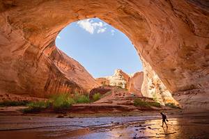
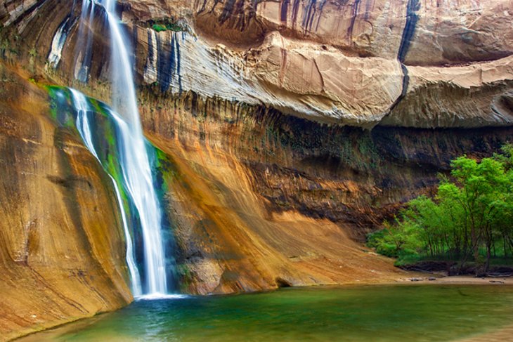
Grand Staircase-Escalante National Monument

Grand Staircase-Escalante National Monument is a huge area of rugged terrain, with a landscape of canyons, arches, hills, waterfalls, forest, and scrubland. It offers a sense of remoteness that is hard to find in other parks.
Dirt roads, where you can drive great distances without ever passing another vehicle, are all part of the experience. Covering 1.9 million acres, this is the largest national monument in the United States, and it's managed by the Bureau of Land Management, not the National Park Service.
Hiking is a popular way to explore the region. Lower Calf Creek Falls Trail offers some fabulous scenery and is one of the most photographed locations in Grand Staircase-Escalante.
In the southern part of the monument is Paria, a town near the Paria River, founded in 1865, but abandoned by 1920. Remnants of the town and the nearby areas have been used in a number of Western films.
The park offers camping, but if you're looking for a little more luxury, one of the best resorts in Utah is right next to Grand Staircase-Escalante.
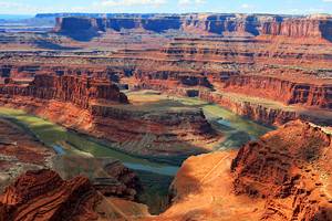
Dead Horse Point State Park
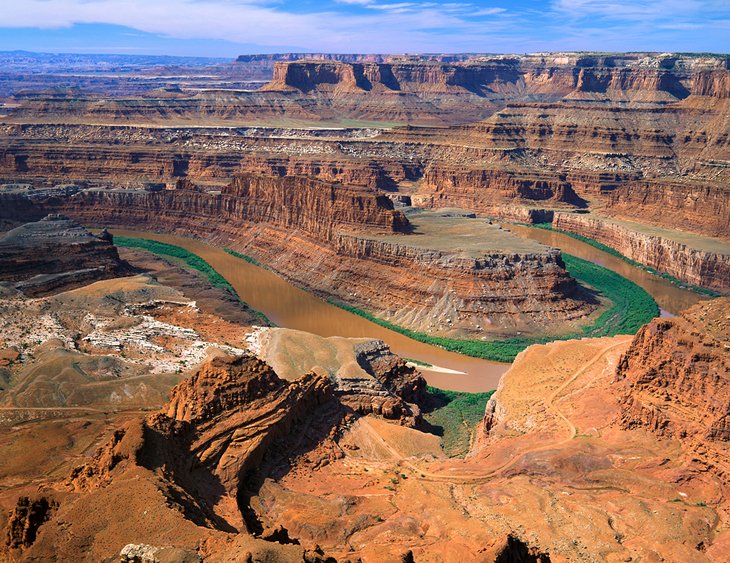
Dead Horse Point State Park, just outside of Moab, delivers one of the best lookouts of any state park in Utah. The main viewpoint looks over a gooseneck in the Colorado River carving through the colorful landscape. Cliff walls rising 2,000 feet and plateaus at various levels stretch out into the distance.

On a shelf of land below the viewpoint, the Potash Road runs along a ledge. Looking to the left along this road, you can see Thelma and Louise Point, where the final scene of the motion picture Thelma and Louise (the characters drive off the canyon rim to the river below) was filmed.
The best way to see the sights at Dead Horse Point State Park is to take a stroll on the walking trail along the rim.
This park is located in the same vicinity as Canyonlands National Park, Island in the Sky district. It's best to visit both of these on the same day.
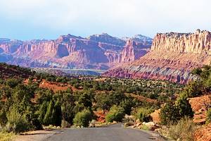
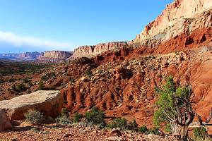
Capitol Reef National Park
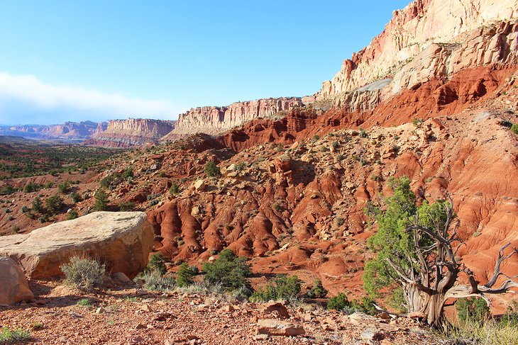
Capitol Reef National Park is another great place to explore Utah's interesting landscapes. Located directly west of Canyonlands National Park, Capitol Reef reveals a huge wall of banded sandstone rising above the Fremont River.
The canyons, rock spires, cliff walls, arches, and gorges are an inspiration for anyone with an interest in photography. From a distance, the wall dominates the landscape and glows an almost purple color in the late-day sun.
Most people come here for sightseeing, but you'll also find a variety of hiking trails in the area. This park sees far fewer tourists than most of the other big parks in Utah, which can be a refreshing treat.
The nearest town to Capitol Reef is Torrey, to the west of the park, where you can find accommodation and camping options. The park's visitor center is 15 minutes from town and located at the start of the beautiful Capitol Reef Scenic Drive, one of the main highlights of a visit to the park.
St. George
St. George's position in southern Utah, near some incredible parks, makes it a convenient city to base yourself if you're interested in outdoor activities. But, even if you're not, the town has its own attractions and is worth a visit.
Zion National Park is just an hour away, and one of Utah's great undiscovered natural areas, Snow Canyon State Park, is less than 20 minutes away. Within a half-hour drive of St. George, you'll find outstanding hiking trails, as well as beautiful areas to camp.
The city of St. George has a number of attractions and things to do related to its Church of Jesus Christ of Latter-day Saints history, including the St. George Temple and the Brigham Young Winter Home Historical Site. Pioneer Park and the adjoining Red Hills Desert Garden are also must-see sites.
St. George is less than a two-hour drive from Las Vegas.
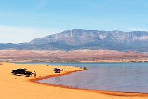
Sand Hollow State Park
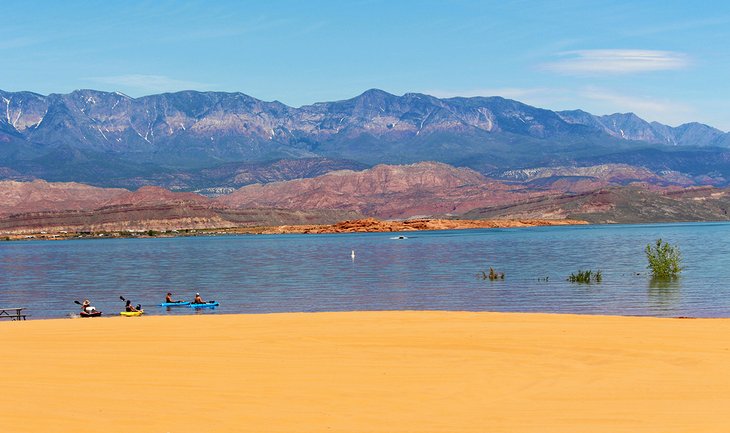
Just down the road from St. George is one of Utah's best state parks, Sand Hollow. This unique park holds a large lake with several unique features. At one end, exposed sandstone rocks descend into the clear waters; at the other, sand dunes extend towards the water's edge, making for wide and wonderful beaches, some of the best in Utah.
The park is one of the most popular places to camp near St. George, with sandy, but tight sites located just back from the beach at the Sandpit campground, or for the RV set, the West Side campground is near the entrance and is more spread out.
Sand Hollow State Park is full of great things to do, like motorized off-road riding in the 15,000 acres of sand dunes, swimming in the warm waters, kayaking, and pleasure boating.
Snow Canyon State Park
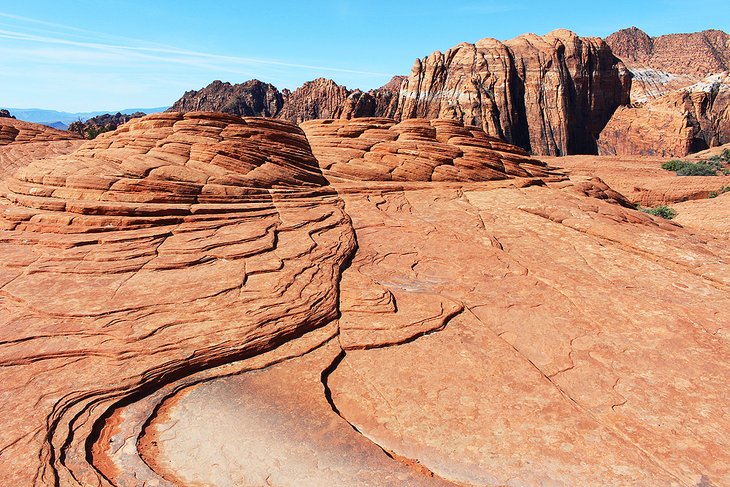
Located mere minutes from downtown St. George is Snow Canyon State Park. Somewhat overshadowed by the famous national parks nearby, this amazing state park has the best of everything the big parks have but all packed into a relatively small area and without the crowds.
Take one of the many wonderful hiking trails across petrified sand dunes to see the spectacular red and tan rocks tower up from the valley floor against impossibly blue skies. If you'd like to get underground, climb down into one of the lava tubes, and give some thought to what fiery events once took place here. If slot canyons are your thing, the park has those, too.
A popular campground attracts RVers and tenters from across the country to its scenic sites.
Cedar Breaks National Monument

The same forces of nature that shaped Bryce Canyon were at work in Cedar Breaks National Monument, creating a smaller but equally dynamic-looking amphitheater. Dominated by colorful hoodoos, the amphitheater is more than 2,000 feet deep and three miles in diameter.
Located at an elevation of 10,000 feet, the park sees full-on winter conditions, with snow covering the monument from fall until spring. Cedar Breaks is technically open year-round, but the scenic drive through the park (Highway 148) is closed from approximately mid-November to late May or June. The campground closes in late September.

The best views can be seen from the Rim Drive. A number of short hikes along the rim and through alpine meadows and forest offer good views of the canyon and access to a few bristlecone pines.
The Spectra Point and Ramparts Overlook Trail is a popular four-mile route along the edge of the plateau that leads to a viewpoint of the spectacular Cedar Breaks Amphitheater. You can also see ancient bristlecone pine trees on this hike. These majestic trees only grow at the highest elevations, generally around 10,000 to 11,000 feet.
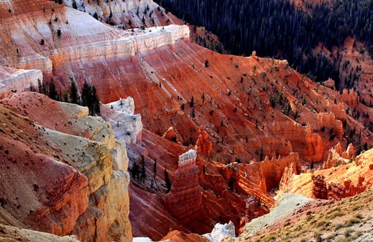
Less spectacular, but interesting nonetheless, is the Alpine Pond Trail, a circular, two-mile hike to a subalpine forest glade and a pond at the end of the trail.
Natural Bridges National Monument
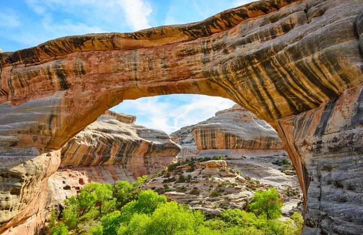
South of Canyonlands National Park, but somewhat out of the way, is Natural Bridges National Monument, protecting some outstanding formations. If you are in the vicinity, or if you haven't had an opportunity to view a natural bridge before, this park is definitely worth a stop. The main tourist attractions are three natural bridges; Kachina, Owachomo, and Sipapu, all of which are accessible by short hikes.
If you are only going to visit one, make it Sipapu, the largest and most impressive of the three. The walk in is a moderately strenuous, 1.2-mile round-trip hike, and it involves navigating steep sections and climbing a few stairs and ladders.
Kachina Bridge is reached by a 1.5-mile round-trip hike, but the trail is easier, although it still has some steep sections.
Owachomo Bridge is the easiest to reach, requiring less than a half-mile round-trip walk. It is the smallest of the three but still worth seeing.
Also of interest in the park are the Horsecollar Ruins, revealing the remains of ancient Native American buildings inhabited more than 700 years ago.
Dinosaur National Monument
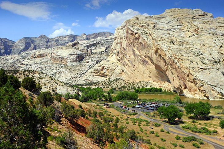
Dinosaur National Monument is known not only for the large number of Jurassic period fossils that have been discovered here but also for the surrounding terrain. The main highlight is the collection of more than 1,500 dinosaur fossils, which can be seen embedded in the cliff wall of Carnegie Quarry.
The new Quarry Hall has been built right over top of a section of the rock, allowing for close-up access and comfortable conditions for visitors. Hiking, rafting, and camping are also popular activities at Dinosaur National Monument.
Dinosaur National Monument straddles the Utah and Colorado border, in the northeast corner of Utah.
Great Salt Lake
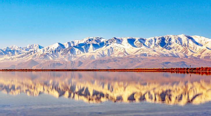
The Great Salt Lake, a half-hour drive northwest of Salt Lake City, is the largest inland lake west of the Mississippi, measuring 72 miles long, 34 miles wide, and up to 50 feet deep. It is a remnant of a much larger freshwater lake, Lake Bonneville.
Following a fall in the water table, this lake was left with no outlet and shrank as a result of evaporation, leaving the Great Salt Lake Desert. The combination of evaporation with the inflow of surface waters rich in minerals led the salt content of the lake to rise steadily, and at one stage it reached 27 percent (eight times as high as the world's oceans).
At the south end of the lake are bathing beaches and a recreation park. Like the Dead Sea in Israel, the Great Salt Lake is salty enough to allow bathers to float without sinking.
Bonneville Salt Flats
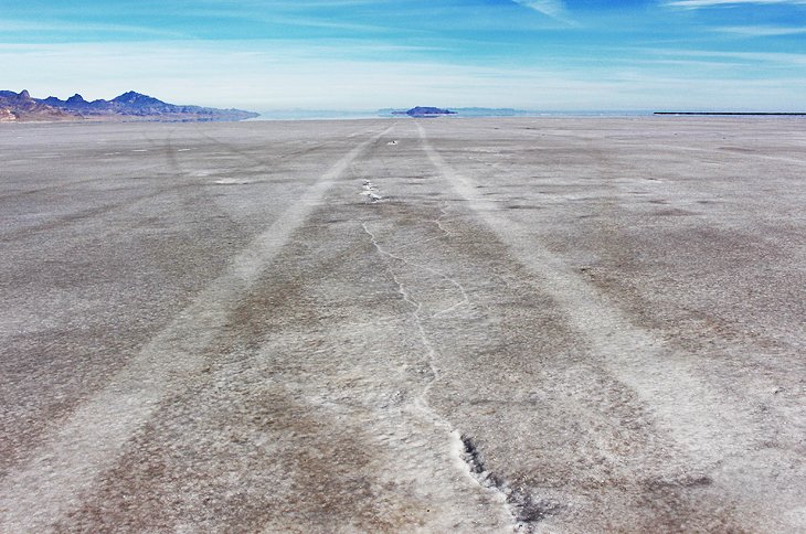
About 90 minutes west of Salt Lake City along I-80, near Wendover, is an unassuming area of flat land, extending off into the distance as far as the eye can see. But during certain times of the year, this area becomes the world's fastest race course.
This natural salt flat is perfectly flat, devoid of all vegetation, and most of the time has a hard surface, making it perfect for high speeds. Speed Week is held here each year in August and World of Speed is held in September. These races have produced world land-speed record runs.
Most of the time it's completely empty, and you can try it out for yourself. If you venture out here when no event is taking place, you'll find little more than a sign on the side of the road and endless miles of salt flats. Take exit 4 off I-80, turn right, and drive past the truck stop. There is nothing else out here. Eventually, you'll come to a sign and an area where you can drive onto the flats at your own risk.
In winter, some areas of the salt flats are covered in a thin layer of water and are not drivable.
Coral Pink Sand Dunes State Park
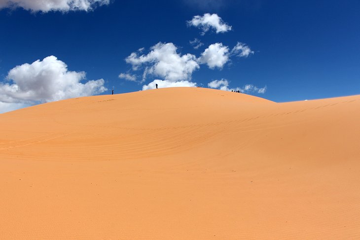
The coral-pink color of the sands at this park makes for an interesting twist when it comes to sand dunes. Sculpted by the wind, the shifting dunes and rolling hills are also a fun place to play. Popular things to do here, beyond simply climbing the soft sand mountains, are sandboarding, ATVing, and of course, photographing the scene.
While the park is mainly used for day-use visits, a pleasant campground is located on the edge of the dunes, with sites sheltered by small trees.
Coral Pink Sand Dunes State Park is set in southern Utah, about an hour and a half east of St. George and 30 minutes west of Kanab.
Official Site: https://stateparks.utah.gov/parks/coral-pink/