National and State Parks in Utah
Author Lana Law has spent many seasons in Utah exploring the national and state parks and hiking countless trails.
Utah's national and state parks are some of the best places in the state for memorable outdoor experiences and sightseeing. The inspiring landscapes of arches, canyons, rivers, lakes, and sand dunes, make it a paradise for nature lovers and a playground for adventurers.
The five national parks, termed the "Mighty 5" by the state, and dozens more state parks and national recreation areas, offer an array of vacation choices for hikers, campers, sightseers, and roadtrippers. Each park has unique attractions, sights, and geology.
The parks listed below are among the top attractions in Utah. Some are more well-known than others for specific interests, such as hiking, climbing, boating, or off-roading. Your favorite may depend on what you're most interested in doing or seeing.
Many of the parks are close together so you can usually work in at least a few in one trip even if you only have a week. Plan a route and see as much of the state as your time will allow with our list of the best parks in Utah.
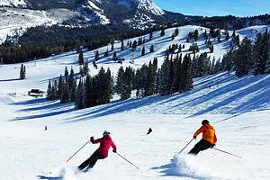
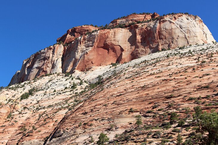
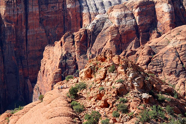
Zion National Park
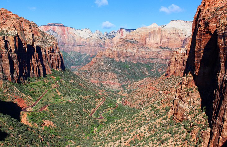
Best National Park in Utah for Hiking
Not surprisingly, Zion is one of the most visited parks in the United States and it's home to one of the most breathtaking landscapes in the Southwest. Massive cliff walls and mountains line the valley, leading to the term "vertical park," which is often used to describe Zion. In the spring, waterfalls pour off the ledges, feeding the Virgin River as it flows through the canyon.
Hiking in Zion: This is the top destination in the state for hiking and is home to some of the most famous trails in the Southwest. The two most iconic hikes, which you've probably heard of and seen videos of, are Angels Landing and The Narrows. These are two extremely challenging hikes but Zion has numerous hikes for all levels of hikers.
Zion has an extensive system of hiking trails that take you through canyons and along the ridges high above. You can immerse yourself in the scenery by hiking below the giant rock walls, alongside rivers, or, fearless hikers can experience the grand views from lookouts more than 1,000 feet above the canyon floor.
Scenic Drives and Shuttle Service: Two scenic roads offer access to the park and attractions. From spring until fall, a free shuttle service transports visitors along the Zion Canyon Scenic Drive. This is a spectacular in-and-out drive through the heart of the park and many key hikes start along this section of road. Visitors can hop on and off at any and all of the stops along the way. During the winter months, this road is open to private vehicles.
Zion-Mount Carmel Highway is the other scenic drive. Like the Zion Canyon Drive, it also has many trailheads and outstanding viewpoints. This road is open year-round to private vehicles and it transits the park from west to east. The only watch-out with this road is the Zion-Mount Carmel Tunnel. RVs must pay a fee and get a permit in advance to pass through the narrow tunnel and hours for these oversized vehicles are restricted (8 to 4:30 at the time of writing).
Camping: You can find campgrounds right in Zion National Park. The most convenient of these are South Campground and Watchman Campground, both near the South Entrance to the park. You need to book these well in advance. South Campground has been undergoing renovations and was closed at the time of writing.
Other popular private campgrounds can be found outside of the park in the nearby towns of Springdale and Virgin. For more details, see our complete guide to camping at Zion National Park.
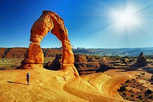
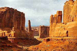
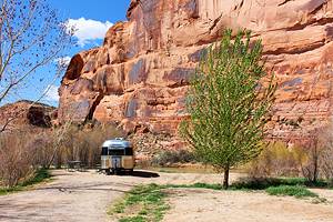
Arches National Park
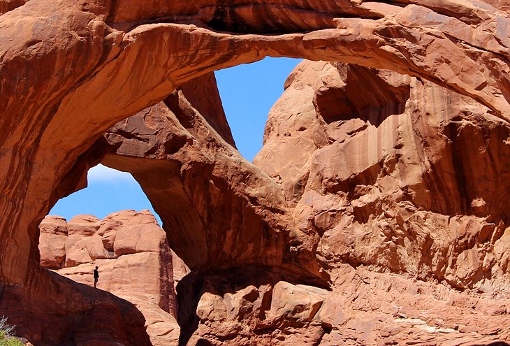
Best National Park in Utah for Natural Arches
Arches is simply a fascinating park. With more than 2,000 sandstone arches, Arches National Park has the highest concentration of natural arches in the world. You can see some of them even from your car window as you drive along but it's best to park and walk up for a closer look. Fortunately, Arches offers plenty of opportunities to access the natural attractions on hikes and short walks and see them from different perspectives.
The park is also home to giant stone fins, spires, slickrock, sand dunes, and beautiful views stretching to the distant La Sal Mountains.
The freestanding horseshoe-shaped Delicate Arch is the poster child for the park, perched majestically on a cliff wall in front of a sandstone bowl. You'll probably recognize it from Utah's license plates, where the arch features prominently. You can only see Delicate Arch from a distance unless you hike to it, and this is one of the longer but most popular hikes in Arches. Other highlights are
If you are planning on visiting the park between the start of April and the end of October, you'll need to reserve a timed entry to the park between 7am and 4pm. Book these well in advance if you can.

Hiking and Key Sights in Arches National Park: Short walks and hiking trails lead to spectacular sites, most of which are easy enough to be enjoyable for small children. Everyone wants to hike to Delicate Arch, which is about a 3-mile round-trip hike and one you should do if you have the chance and it's not a blazing hot day.
Other highlights are the hike to Landscape Arch (1.8 miles), with optional spurs to Pine Tree Arch (a must-see) and Tunnel Arch; the short walk to Double Arch in the Windows area (a must for photographers); and Sand Dune Arch, which is a beautiful arch tucked between other rock formations and surrounded by sand.
Camping: Camping in Arches National Park is possible but must be booked in advance. However, you can find beautiful places to camp near Arches, in other parks, at BLM campsites, and at private campgrounds in Moab. See our guide to camping near Arches National Park and Moab.
Nearby Town of Moab: The town of Moab is the perfect place to base yourself if you're visiting the park. Just a few minutes from the entrance, the town has a fantastic vibe and numerous hotels. The area around Moab is famous for its mountain biking, particularly the Slickrock Bike Trail. Visiting the parks and biking are the top things to do in Moab, but the list of scenic drives and natural attractions surrounding the town are extensive.
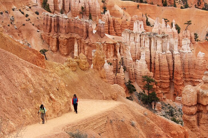
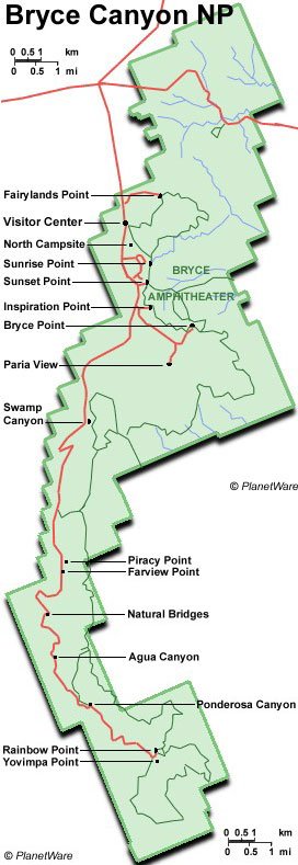
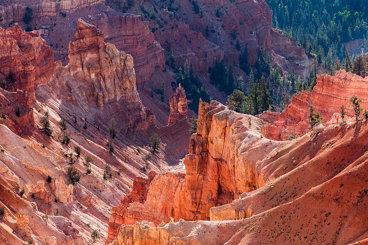
Bryce Canyon National Park

Best National Park in Utah to see Natural Amphitheaters and Hoodoos
Bryce Canyon National Park is a fantasy world of towering hoodoos lining a giant amphitheater. In the sun the stone spires and balanced rock formations glow in shades of orange, gold, cream, and pink. From the lookouts along the canyon rim, you can peer out over the bowl of hoodoos into an almost surreal landscape.
The most striking views are from Sunset and Sunrise Points, along the Rim Trail. To get a different perspective, take a walk along one of the hiking trails that carve through the canyon and meander around the base of these giant spires and oddly shaped stone formations.
The park, set at an elevation of between 8,000 and 9,000 feet, is also home to a small number of bristlecone pines, a less common sight in this part of Utah.
Camping: In the park are some beautiful campgrounds set among the pines. Nearby you can find RV parks and remote camping options. The most important thing to note is that due to the high elevation, camping here can be cold, even in the hottest months. Have a read through our guide to camping at Bryce Canyon.
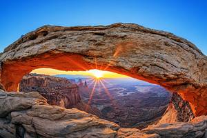
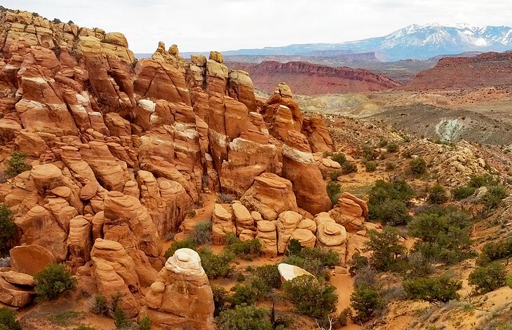
Canyonlands National Park
Best National Park in Utah for Canyon Vistas
Canyonlands is Utah's equivalent of Arizona's Grand Canyon. For fabulous vistas, you can't beat this park. It also gets only a fraction of the visitors as parks like the Grand Canyon, Zion, and Arches, making it a pleasure to visit.
The Island in the Sky section of Canyonlands National Park is about a 30-minute drive from Arches National Park, these two parks are often visited in the same vacation, but each requires a significant amount of time.
Canyonlands National Park is broken out into three main districts. Island in the Sky is the most popular, followed by Needles, and in a much more remote area that many tourists never get to is the Maze. The fourth district, which gets little mention, is the rivers that divide these areas.
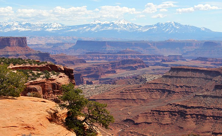
Island in the Sky District: The view from the Island in the Sky district of the park, looking out over the carved landscape of plateaus and canyons, is one of the most awe-inspiring sites in the entire state. This is a must-see for visitors and the highlight of Canyonlands National Park.
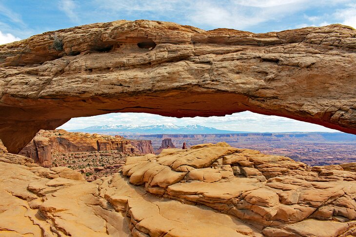
This is also where you can do the short hike to Mesa Arch, a beautiful and dramatic arch perched on the edge of a 500-foot drop, framing the distant landscape. And these are just two of the sites in this one section of the park.
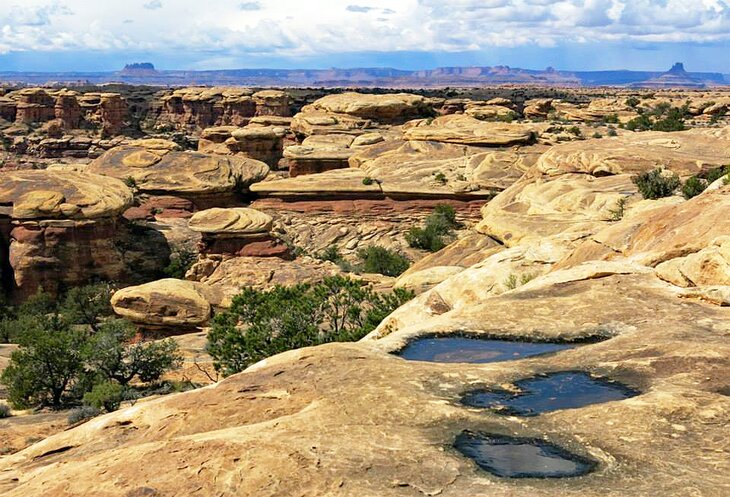
Needles District: The Needles district also displays a dramatic, although much different landscape, and is an excellent area for longer hikes and four-wheel driving. This area puts you more into the landscape, rather than just looking out over it.
It's located about an hour-and-a-half drive south of Island in the Sky and has a much more remote feel. It's spread out and you should plan on some time to drive around and do some hiking. This area also has various camping options.
The Maze District: The third area, the extremely remote Maze district, is less visited and more difficult to access. It is really only for those well-prepared for remote and rough conditions. Be sure to check with the park website in advance for details if you plan on visiting this area.
Camping: Each of these areas offers camping. You'll find quality organized campgrounds in Island in the Sky and Needles, as well as more remote options for boondocking and pitching a tent.
Nearby Town: Island in the Sky and Needles are both within an hour of the town of Moab, not far from Arches National Park. Most people visit all three of these if they are in the area.
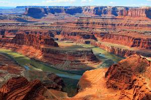
Dead Horse Point State Park

Highlights: Canyon Scenery
If you visit only one state park while you're in Utah, it should be Dead Horse Point. One of the most spectacular viewpoints in Utah is from Dead Horse Point Lookout, with views over a gooseneck in the Colorado River, 2,000 feet below.
Looking down and to the left, you can see what is called "Thelma & Louise Point." The final scene from the movie of the same name, portrayed as a car driving over the edge of the Grand Canyon, was actually filmed here. You can also see the Potash Road as it follows the cliff of the plateau below.
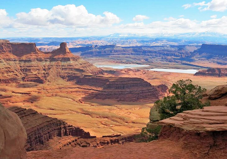
Several hikes lead to dramatic lookouts on both sides of the point. If you are up for a longer hike, the seven miles of trail are connected and can be done as one long hike.
The lookout at Dead Horse Point State Park is about a 45-minute drive from Moab.
Camping: The park has two campgrounds, the first is the Kayenta Campground. It has just over 20 sites and can accommodate RVs and tents. The second campground is the Wingate Campground home to 32 sites that accommodate RV's and tents (11 are tent only). Yurts are also available at both campgrounds. Make a reservation in advance if you want to camp here.
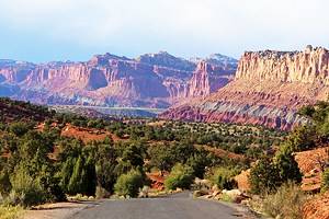
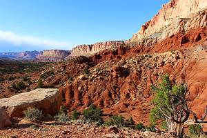
Capitol Reef National Park
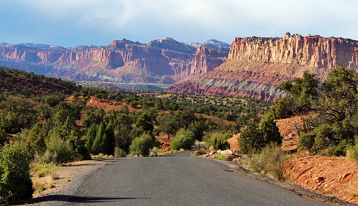
One of Utah's "Mighty 5" parks, Capitol Reef National Park is another area of impressive rock formations. Approaching from the south, particularly in the late day when the sun is low in the sky, Capitol Reef looks like a giant wall of orange, pink, and purple hues on the horizon.
The scenic drive through the park provides a close-up look at the most dramatic section, but you'll also find interesting stops as you approach the park's visitor center coming from the town of Torrey, including Goosenecks Overlook and Panorama Point.
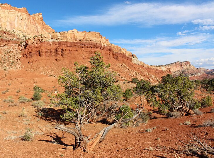
Less visited than the other major parks, Capitol Reef offers a different experience, with less people, more solitude, and a feeling of tranquility. This park does not require as much time to see as places like Arches, Canyonlands, or Zion National Park, but it's definitely worth a stop.
Camping: The park offers incredible opportunities for camping and has one of the nicest national park campgrounds in Utah. Backed by orange cliffs and hedged in by an orchard, Fruita Campground is just 15 minutes from the town of Torrey, near the start of the park. You'll also find several smaller camping areas along the scenic drive in the park, and RV parks outside the park.
Nearby Town: The closest town to the park is Torrey, a pleasant little community with hotels and restaurants.
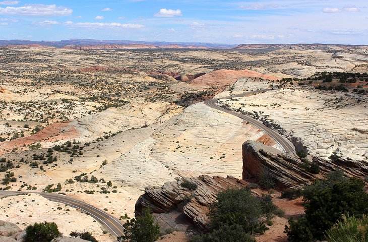
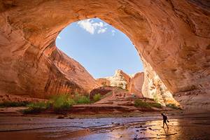
Grand Staircase-Escalante National Monument
Highlights: Rugged Scenery, Remote Roads, and Waterfalls
The largest US National Monument by landmass, Grand Staircase-Escalante is a rugged, diverse, and largely remote area of southern Utah.
A spectacular drive from Bryce Canyon to Capitol Reef takes you through Grand Staircase-Escalante, along Scenic Byway 12. Seemingly endless waves of slickrock dominate large sections of the park, including this stretch.
Highway 89, along the southern edge between Kanab and Page, offers even more dramatic views of colorful banded hills and canyons. You can stop off at the Paria ghost town and nearby recreated Old West town, both of which have been used as filming locations in movies.
This area is surrounded by some outstanding scenery of mountains and washes. For those who head into the interior, a land of colorful canyons, cockscomb ridges, arches, and even waterfalls can be reached by dirt roads and hiking trails.
One of the highlights is Lower Calf Creek Falls, reached by a 6-mile round-trip hiking trail.
Cedar Breaks National Monument
Highlights: Canyons, Hoodoos, Spires, and Ancient Bristlecone Pines
Cedar Breaks National Monument is similar in many ways to Bryce Canyon, with a deep amphitheater of towering hoodoos and surrounding walls of multi-hued stripes that glow in shades of orange, pink, gold, and cream. Compared to the big national parks in Utah it has a much more remote feel and sees far fewer visitors.
At an elevation of over 10,000 feet, the park is closed in winter, when the access road is covered in snow, and in the summer, the cool climate is a refreshing treat from the heat of lower regions. This high elevation means it's also a good place to see ancient bristlecone pine trees, some of which are over 1600 years old.

Scenic lookouts and a few short hikes that skew towards easy are the main ways to see the park. The visitors' center is a good first stop. From here you can get information on where to go and what to see but it's also where you'll find the main viewpoint over the amphitheater and where the trail to Spectra Points begins, which is one of the key highlights.
Spectra Point is one mile along the South Rim Trail, the most popular hike in Cedar Breaks. The entire trail is rated as strenuous by the park but the hike to Spectra Point is relatively easy. Spectra Point offers a fantastic view, comparable to the one from the visitors' center, but it's also where you can see some of the ancient bristlecone pines.
The best time of day to visit viewpoints in the park is in the late afternoon. The rim faces west and in the morning the hoodoos are mostly in shadow.
Also, with many deciduous trees, the park becomes a colorful spectacle in the fall, when the leaves turn a bright yellow and orange.

Camping: The drive up to the park is long but paved and easy, even for RVs. Camping is available in the park at Point Supreme Campground. This is a lovely campground with big trees and large, well-spaced sites. Of the 25 sites, 7 are tents only, there are no hookups, and the campground doesn't have a dump station. Due to the extremely high elevation, nights are cold. In summer, the overnight lows fall to the 30s and 40s Fahrenheit.
This is also one of the few campgrounds where you can usually reserve a campsite on short notice, apart from weekends.
The park is open from late May to mid-October but the campground closes in late September.
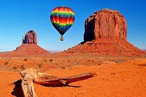
Monument Valley Navajo Tribal Park
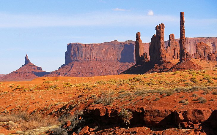
Best Natural Area in Utah to see Wild West Landscapes
Monument Valley, the setting for countless movies, is not a state or national park, but a Navajo Tribal Park on the Navajo Indian Reservation. Huge buttes and pinnacles rise up from the valley floor like stone castles of the desert.
The red and orange sandstone against the piercing blue sky creates stunning images. Photographers can create true masterpieces here. A scenic 17-mile dirt road weaves through the stone structures, with pullouts all along the route. This road does not allow trailers or RVs but you can take guided tours that take you to places you can only get to with a guide, including red sand dunes and other scenic points. Book tours in advance.

Hiking: The approximately 4-mile Wildcat Trail is the only hike open to visitors without taking a tour. If you can't drive the road or if you are staying in the park, it's worthwhile doing this hike. It takes you into the valley and loops around the famous butte, Left Mitten.
The Visitors Center is a modern building with a large gift shop. The front windows offer a spectacular view out over the valley.
Camping in the Navajo Tribal Park: The View Campground is the only campground inside the park. It's a very basic and completely exposed campground but has incredible views of Monument Valley. Set on a ridge with uninterrupted views, it faces the same direction as the visitors' center and offers a very similar view, as well as vistas across the desert on the backside.


At the end of the day when the day trippers have left the park, you have the place to yourself. The Wildcat Trail leaves from the edge of the campground.
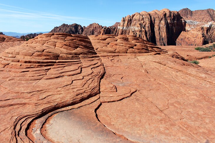
Snow Canyon State Park
Best State Park in Utah for Hiking and a Varied Landscape
This pocket of magnificent scenery in southwestern Utah, near St. George, is overshadowed by the bigger name national parks in the vicinity but packs a big punch for its size. Snow Canyon State Park also offers sights you can't see or easily access in places like Zion National Park, including black lava fields and lava tubes, some of which you can scramble down into.
Other things to do include walking along waves of petrified dunes, entering a slot canyon just a 10-minute walk from the road, and searching out some outstanding lookout points.
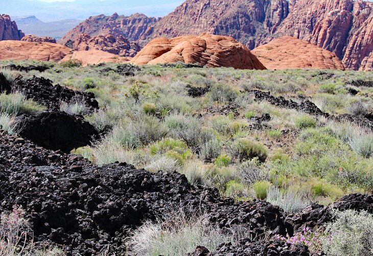
This park is one of the most popular hiking areas near St. George and yet offers solitude you won't easily find in many of Utah's national parks.
Camping: Snow Canyon State Park has one campground, and it's the best campground near St. George. But sites are limited, and you'll need to book well in advance to secure a spot.
Nearby Town: Snow Canyon State Park is just 15 minutes outside of St. George. This is a city of about 100,000 people and a full range of hotels and accommodation options. You'll find plenty of things to do in St. George, which makes a good base for a few days.
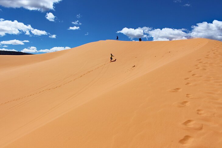
Coral Pink Sand Dunes State Park
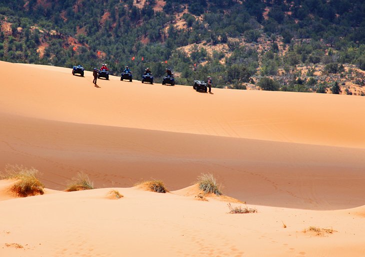
Best State Park in Utah for Sand Dunes and ATVing
Small but unique, Coral Pink Sand Dunes is a fun place to spend a day playing on the dunes. Sculpted by the wind pattern created by the Moquith and Moccasin Mountains, the dunes here reach about 100 feet in height. Like the orange cliffs that dominate nearby national parks in Utah, the sand here is Navajo sandstone.
You can try your luck sandboarding down the dunes, but most people opt to run down them. A nature trail on the edge of the dunes features plaques with information on the sites.
This park is an extremely popular place for people who come here with ATVs. However, there is plenty of space, and they aren't likely to bother people on foot. Operating ATVs is not permitted during quiet hours in the morning and evening, so they do not disturb campers looking for tranquility.
Camping: You can camp at Coral Pink Sand Dunes. Sites are set among juniper and pinion pines. The park is at an elevation to about 6,000 feet and evenings can be cool.
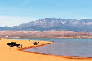
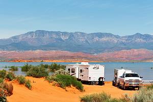
Sand Hollow State Park
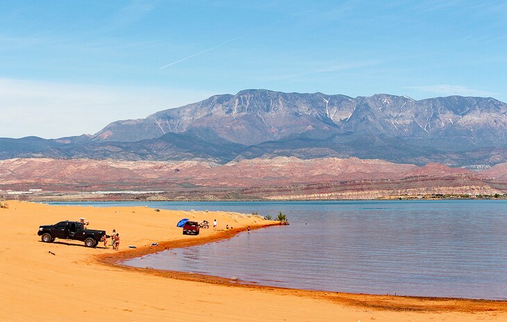
Highlights: Beaches, Water Sports, and ATVing
Sand Hollow State Park is home to one of the best beaches in Utah. It is lesser known by out of state residents but is a hot spot with locals who come here to hang out on the beach, boat, fish, kayak, or take their OHVs (off highway vehicles) into the surrounding sand dunes.
A beautiful, coral-colored soft-sand beach stretches all along the west and south side of the lake, forming a wide band between the lake and road. On the opposite side of the lake, mountains add to the scenery.
In some areas, you can drive your vehicle right down to the water's edge and set up on the shoreline. Note that the sand is soft and deep, don't want to drive off the road without a four-wheel-drive vehicle.
Camping: The park has two campgrounds, as well as primitive campsites along the beach in the dunes.
Goosenecks State Park
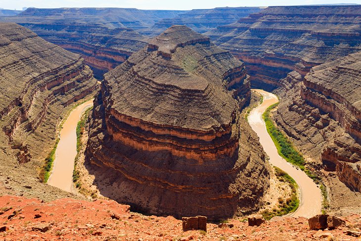
Highlights: Incredible Views over a Bend in the San Juan River
This small park is worth a stop for the outstanding view of a meander in the San Juan River, 1,000 feet below the lookout. Beyond, dramatic scenery stretches into the distance, where the river has carved its way through the landscape.
To get a complete view, or to photograph a gooseneck showing the water flowing all the way around the bend, you need to inch your way out to the very edge of the unguarded viewpoint ledge. Beware of high winds before you consider approaching the ledge.
Goosenecks State Park is in a remote part of southern Utah but is a convenient stop if you are visiting Monument Valley. The park also has eight first-come, first-served primitive campsites, with vault toilets and no water. The campsites are free of charge.
Natural Bridges National Monument
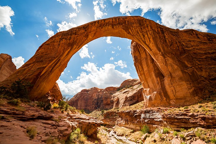
Best National Monument in Utah to See Huge Natural Bridges
Three large natural bridges are the highlight of Natural Bridges National Monument, located in southeastern Utah. If you are not planning a stop at Arches National Park, then this park is definitely worthwhile. Hiking trails that offer access to these high bridges range in length from 0.4 to 1.4 miles in length.
Unlike arches, which are formed by many types of erosion, natural bridges are formed primarily by erosion from water. These three are quite spectacular, but the park has a number of other interesting features, including Horse Collar Ruins. These well-preserved Puebloan cliff dwellings, dating back more than 700 years, can be seen from a short overlook trail.
Camping: Natural Bridges National Monument has a first-come, first-served campground near the visitor center. Sites do not have water or electrical, and are set among juniper pines.
Flaming Gorge National Recreation Area
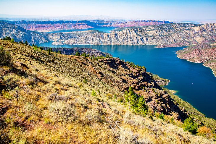
Highlights: Boating, Water Sports, Scenery
When most people think of Utah and water, it's generally the Great Salt Lake near Salt Lake City. Less known to those from out of state is Flaming Gorge State Park. Created by damming the Green River, this huge reservoir is a hot spot for outdoor activities. Flaming Gorge State Park is located in the far northeast corner of the state right near the Wyoming state line.
Activities here include boating, water skiing, sailing, kiteboarding, and houseboating, making this one of the most popular recreation destinations in the state.
In addition to the active water sports, Flaming Gorge State Park is noted for its world-class lake trout fishing. Catches in the 30 pound range are a fairly regular occurrence, with the occasional 40 pounder bending a rod as well.
A five-mile hike called the Red Canyon Rim Trail runs along the edge of the gorge and provides amazing views from cliffs that reach 1,400 feet above the canyon floor.
Camping is available at the Canyon Rim campground and at a nearby RV park in Manila.
Antelope Island State Park
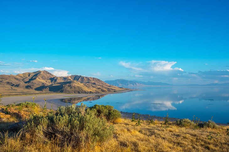
Highlights: Nature Trails, Wildlife Viewing, and the Great Salt Lake
If you are staying in Salt Lake City and only have time for one recreational outing during your visit, give Antelope Island State Park a try. Only an hour from downtown, this fascinating park is one of the best places to see the Great Salt Lake.
Hills crisscrossed with hiking and biking trails allow you to get out and explore the 42 square miles of this island park. As you make your way, keep an eye out for bison, deer, birds, and, of course, antelope. Views from the top out over the Great Salt Lake are not to be missed, and sunsets from up here are spectacular.
If you'd like to go for a swim, a massive beach awaits you, but bear in mind that it can be a bit messy and smelly at certain times of the year.
For a bit of pioneer history, swing by the Fielding Garr Ranch.
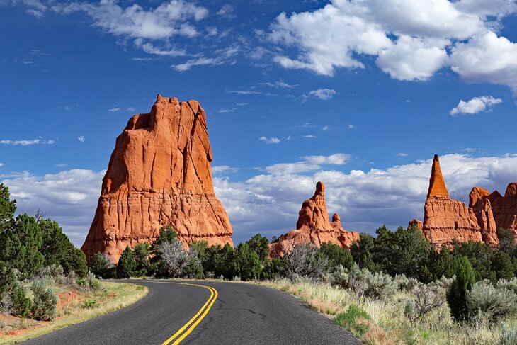
Kodachrome Basin State Park
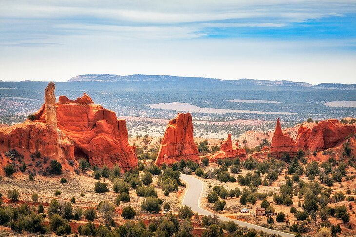
Highlights: Colorful Spires and Camping
There's a reason Kodachrome Basin State Park is named after the infamous brand of photographic film — the place is spectacularly beautiful, and you can't help but snap a picture or two. The main attractions are the interesting spires, 67 in total, in various shades of orange and cream.
The main activities here are hiking, mountain biking, and horseback riding. Many trails wind their way past the park's most impressive sights.
Nearby is the world-famous Bryce Canyon — it's an easy 35-minute drive and a must-do when visiting Kodachrome State Park. Also close by is one of Utah's most famous arches, Grosvenor Arch. This massive arch, which is actually two arches, is 10 miles down a bumpy road from the visitor center.
Camping: The park is a popular place to camp with three campgrounds (two well equipped, one primitive).
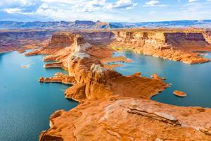
Map of Utah National and State Parks
Explore More of Utah's Great Outdoors
Camping in Utah: The state and national parks offer some of the best places for camping, but you can also find awesome out-of-the-way BLM (Bureau of Land Management) campgrounds, as well as quality private RV campgrounds, near the major parks. With nearby Arches and Canyonlands National Parks, the area around Moab is one of the best places for camping in the state. Near Zion NP and Snow Canyon State Park, St. George is another great place for camping.
Hiking Trails: It's worth taking the time to hit the trails in this state, and Utah has trails for everyone, from beginners and families with children to advanced hikers seeking a challenge. For a look at the best hikes from a state level, see our list of the overall best hikes in Utah.