10 Top-Rated Hiking Trails near Victoria, BC
Surrounded by ocean and mountain views, Victoria is one of Canada's most scenic cities. Hiking trails in and around the city take advantage of the area's natural beauty and allow for quick escapes to mountaintops, waterfalls, and even historic sites. Some of the trails are in Victoria; others are up to 1.5 hours away. No matter where you go, the trails will quickly transport you from the hustle and bustle of the city to the peace and serenity of the wild.
The trails range from seaside or lakeside jaunts to forest walks through ancient trees and even heart-pumping mountain hikes. Different trails offer different experiences, but hikers of all levels of ability can find what they're looking for. Trailheads are well signposted, usually with maps, and trails are very well maintained. Most hiking trails are open year-round and are dog-friendly as long as pets are on a leash. Plan your day with our list of the best hikes around Victoria.
- 1. Coast Trail, Sooke
- 2. Mount Work Hiking Trail
- 3. Thetis Lake Hiking Trail
- 4. Mount Doug Hiking Trails
- 5. Niagara Falls Hiking Trail, Goldstream Provincial Park
- 6. Mount Finlayson Hiking Trail
- 7. Kinsol Trestle Bridge Trail
- 8. Mount Tolmie
- 9. Mystic Beach and Sandcut Beach Hikes
- 10. Durrance Lake Hiking Trail
- Where to Stay in Victoria
- Map of Hiking Trails near Victoria, BC
- Victoria - Climate Chart
1. Coast Trail, Sooke
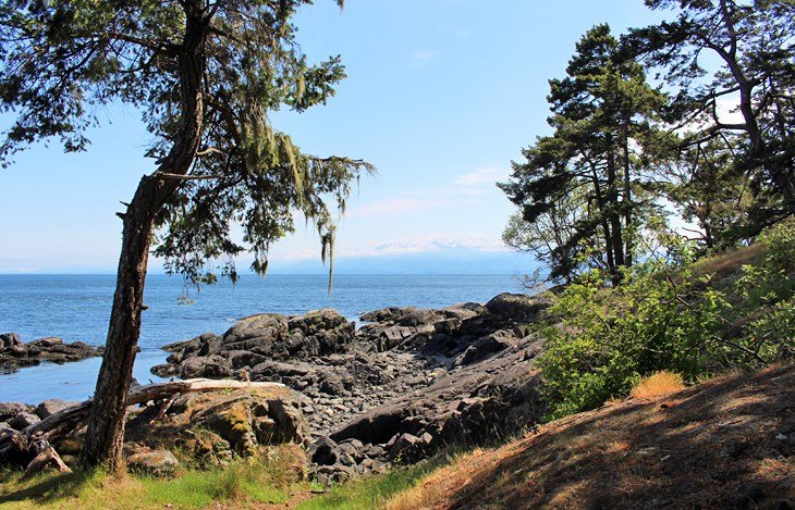
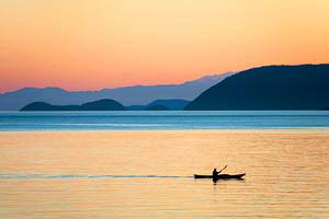
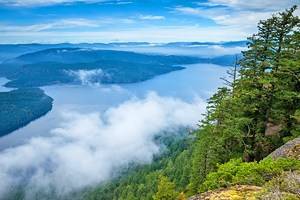
While many of the trails around Victoria take you to peaks or inland attractions, hiking along the coast is spectacular. The Coast Trail near Sooke is one of the most beautiful areas for hiking, with outstanding views to the snow-capped Olympic Mountains and soft-sand beaches to relax and take a break.
This is a 10-kilometer one-way trail, but most people only complete a section of it. The most popular area is accessed from Aylard Farm. Here, the trail begins at a lovely beach area, which is very popular on warm days, and then leads along the coast, meandering through trees and popping out onto rocks here and there.
One popular site along this hike is the petroglyphs. Out on a point overlooking the Juan De Fuca Strait, you'll see ancient images of a seal and a whale inscribed on the rocks. It's easy to miss, but a plaque marks the area.
The start of the hike is located in East Sooke Regional Park, set on a peninsula about 25 minutes from downtown Sooke or 45 minutes from downtown Victoria. The end of the hike is at Iron Mine Bay, a spectacular small cove at the far end of the park. The hike can also be tackled in the reverse direction, however the section from Iron Mine Bay heading south is much more difficult.
2. Mount Work Hiking Trail
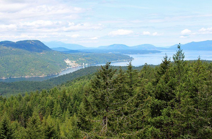
For scenery and a modest workout, look no further than Mount Work. From the top, views to the south look out to the spectacular Olympic Mountains, and views to the north extend down Saanich Inlet. This is a wonderful 4.5-kilometer trail, which winds its way up through assorted large fir, arbutus, and cedar trees to two lookout areas.
The summit view provides the big vistas, where on a clear day, you can see beyond the ocean to the Olympic Mountains. The second view, just short of the top, looks in the opposite direction to Saanich Inlet and Mount Finlayson.
The lookouts offer wide-open areas of exposed rock, perfect for having lunch or just relaxing on a nice day. The trail is a fairly steady climb with the occasional steep section followed by a mellow area of gentle inclines. Total elevation gain is 230 meters. The trailhead is at the Ross Durrance Road Parking Lot in Mount Work Regional Park.
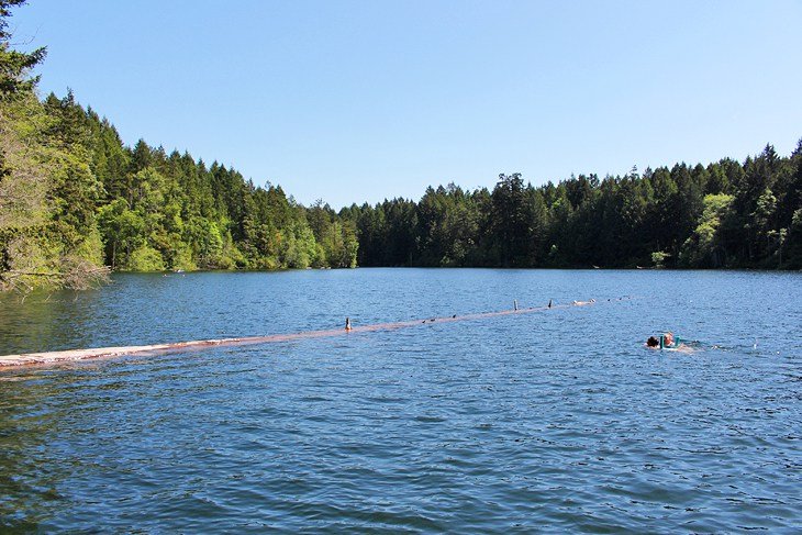
3. Thetis Lake Hiking Trail
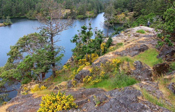
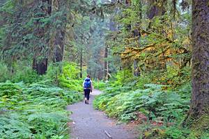
Thetis Lake Regional Park is another multi-use area. Some people simply come to enjoy the beaches near the start of the trail, and others lace up their hiking boots and hike around the lake, which is divided into Upper and Lower Thetis Lakes. While there are several trails in the area, the longer trail takes you from the water's edge up to high rocks that offer fantastic lookouts over the lake and loops around Lower and Upper Thetis Lakes.
Unlike the ocean, the water here is warm and wonderful for swimming. Many people swim off the rocky shoreline along the hike. Arbutus trees add to the scenery. The five-kilometer loop trail is well maintained and gains and loses elevation as it circles the lakes. One of the most scenic parts of the trail follows along the east side of the lake, where you ascend to the top of a rocky bluff.
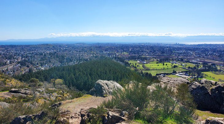
4. Mount Doug Hiking Trails
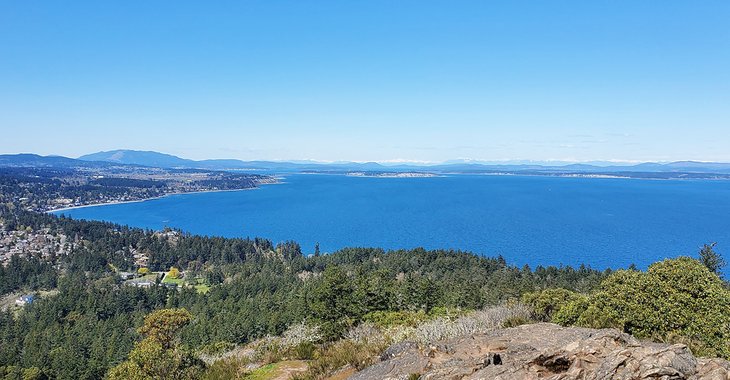
The Mount Doug hiking trail provides one of the best views of Victoria, the surrounding areas, the Olympic Mountains, and if you are lucky, the massive dome of Mount Baker.
Mount Doug is crisscrossed with a multitude of hiking trails, so finding your way to the top can be confusing. An excellent, detailed map is right at the entrance by the big sign welcoming you to the park at the main parking lot off Cedar Hills road.
To get to the top, you have several choices, none of them easy. Count on a tough uphill walk that will get your heart pumping on the way up and your knees aching on the way down.
If your route-finding skills are not up to the task and you prefer a level surface, just continue walking up Churchill Drive beyond the gate as it twists and turns its way 1.5 kilometers to the top. To come back down, just walk the same way.
Should you prefer a more traditional hiking trail that winds its way through large trees, follow the Irvine trail. The trailhead for this route leaves from Churchill drive on the right, just past the bicycle racks in the parking lot. Irvine trail crosses Churchill Drive; you have to make sure to stay to the right of the road heading uphill. If you go left, you'll still make it to the top, but the route is longer, and you will need to connect with both the Whitaker and Glendenning trails, which can be quite steep.
A good option that many people enjoy is to take Irvine trail to the top and walk back down Churchill Drive.
If all this feels a bit overwhelming, you can actually drive to almost the top of the mountain, and walk the final short stretch. Churchill Drive is open to cars from 12 noon to dusk seven days a week.
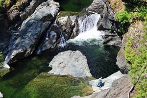
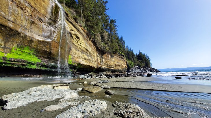
5. Niagara Falls Hiking Trail, Goldstream Provincial Park
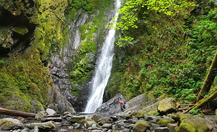
The name of this trail is a bit grandiose; nevertheless, it's definitely worth doing and even includes walking through a tunnel. The trail is relatively easy at 1.3 kilometers round trip, perfect for a family outing.
This is an easy hike to a spectacular 47-meter waterfall tumbling off a sheer cliff face, surrounded by lush vegetation. Depending on how nimble you are, you can walk and scramble right up to the deep pool at the base of the falls.
The falls can be accessed from two parking areas, although one is small and unmarked, making it difficult to find. Most people begin at the day use area on the north side of the highway. This short hike follows a path through a large but short tunnel under the highway, and then continues up the usually dry riverbed towards the falls. If the river is flowing due to recent heavy rains, you'll need to park at the small unmarked parking area on the south side of the highway. From this parking area, it's just a few hundred meters to the falls.
Above Niagara Falls is an abandoned railway bridge from 1910. Many people used to continue on past the falls to this bridge for the thrill of walking out it, and for the views of Mount Finlayson. However, this trail is no longer an option. The access to the bridge has now been blocked, and the trails leading to the area are decommissioned.
6. Mount Finlayson Hiking Trail
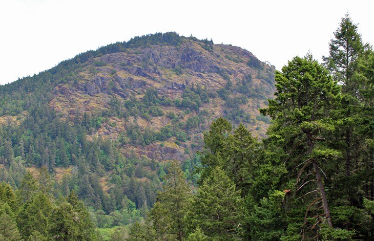
Mount Finlayson is a steep, four-kilometer round-trip hike with significant elevation but provides 360-degree views out over the surrounding areas, and on a clear day, even Mount Baker can be seen in the distance.
There are two routes to the top. The route leaving from the day use area ascends 410 meters, weaving its way through the forest before it emerges onto an open and exposed rock. Some areas will require using your hands to help with the steep climb. The other route, leaving from Finlayson Arm, is a gentler, less busy route and more like a traditional hiking trail. It's recommended that you go up and back the same way in order to end up back at your original trailhead.
7. Kinsol Trestle Bridge Trail
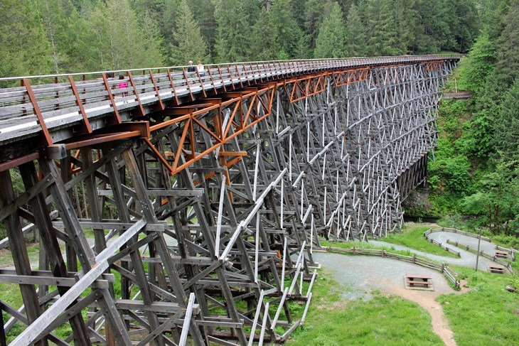
This three-kilometer round-trip hike follows an old railbed. As you can imagine, it's flat and wide and a great trail for any level of ability. People bike, ride their horse, or push a stroller along the path. And while the trail might not be particularly dynamic, the wooden trestle bridge at the end of the path is. One of the world's tallest free-standing timber trestle bridges, it stands 44 meters high and is 187 meters long.
One of the unique features of the design, apart from the size, is the seven-degree curve of the structure. You can walk over the bridge, which no longer has railroad ties but a flat boardwalk instead. At the far end of the bridge, a trail leads down the bank to the river, so you can walk below the bridge. Historical information boards at the start of the trail and on the bridge itself provide background and history of how the bridge was built and later restored.
8. Mount Tolmie
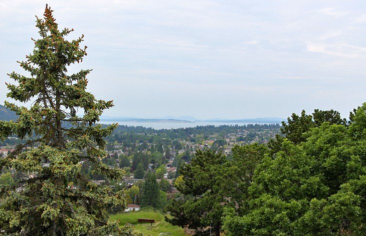
Mount Tolmie is a wonderful walking area right in the city. For hikers who don't want to venture out into the wilderness on their own, this is an attractive alternative. You can drive yourself to the top of Mount Tolmie for 360-degree views out over Victoria and then start your hike. The road twists and turns as it takes you through a beautiful neighborhood and emerges at the top.
Short trails from the parking area and around the peak can be combined to make a 1.2-kilometer loop. You'll see benches and scenic areas along the way where you can relax and enjoy the views. One area of interest at the top is a huge concrete slab dating from WWII, once part of the Canadian defense system. Parking at the very top is relatively limited, however, a larger lot is located a short distance down the hill.
9. Mystic Beach and Sandcut Beach Hikes
If you don't mind venturing out from Victoria, two of the most spectacular hikes along the Juan de Fuca Strait will be your reward. The two hikes are located near Jordan River, just over an hour from downtown Victoria. Both can be tackled in one day, as one is much shorter than the other.
The most impressive is the hike to Mystic Beach to see Mystic Falls. Try to time this hike for low tide and preferably in the afternoon when the sun is hitting the falls.
This is a lovely four-kilometer round-trip hike along the Juan de Fuca Trail, to Mystic Falls. The trail cuts through the forest and over an endless tangle of roots carpeting the forest floor at the base of the huge trees that tower overhead. Along the way, a long suspension bridge crosses over scenic Pete Wolfe Creek. Closer to the beach, the trail descends rapidly over a series of boardwalks and down a long set of stairs, some of which are carved into a giant tree trunk.
Eventually you'll emerge onto Mystic Beach and fantastic views of the Olympic Mountains. Turn left, and walk a short distance to where you'll see Mystic Falls tumbling off a high ledge to the sand below. The falls are in a particularly spectacular setting, with the tumbling surf on one side and dark, rocky headlands to the other.
If you've packed a picnic lunch, grab one of the smooth rocks nearby, or set up under the cliffs and enjoy your meal while keeping an eye out for curious seals in the shallows just offshore. Return the same way you came.
It's very important to wear appropriate footwear on this hike; the trail is full of slippery tree roots and its very easy to turn an ankle. The trail starts at the parking lot for the beginning of the Juan de Fuca Marine Trail. This is the first parking lot on the right you come to when you turn off at the China Beach signs. Follow the signs to the Juan de Fuca Marine Trail; you will not see any signs indicating Mystic Beach, it's only one spot on the longer trail.
This trail can be almost cut in half if you take an unmarked route that leaves from the highway just past the Pete Wolf Creek bridge. Just keep an eye out for cars parked in this area, and you'll know you've found the right spot.
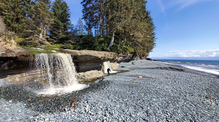
After visiting Mystic Falls, jump back in the car and head back towards Victoria to the trailhead for Sandcut Beach. This is a delightful two-kilometer round-trip trail perfect for families with small children. Most people reach the falls in about 15 minutes. The trail is fun; some of it is on boardwalks, and some is on the back of massive fallen trees.
The trail is easy to follow as it winds its way through huge, moss-covered trees past gurgling streams, eventually ending at a long set of stairs leading to the ocean. This beach is a local's favorite owing to its ease of access and relative obscurity.
At this point, facing the ocean, turn left and walk along the beach to the falls, approximately 500 meters away. The falls tumble majestically off a small ledge onto the beach. The ledge creates a dry area in behind the falls, which is fun to explore and great for photos. To return to the parking area, just retrace your steps.
10. Durrance Lake Hiking Trail
Durrance Lake, in Durance Lake Regional Park, is an easy and short hike around a sparkling blue lake surrounded by tall trees. The trail passes by a picnic area and a small beach near the start and provides views of Mount Werk. The lake warms up in the summer, so bring your bathing suit or at the very least pack a lunch to have at the picnic tables set just back from the water.
The 1.7-kilometer trail begins wide and then narrows as it loops around the backside of the lake. This trail is perfect for all levels of hikers. The parking lot fills up quickly on warm weekends and note that there is no parking allowed on the access road.
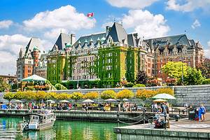
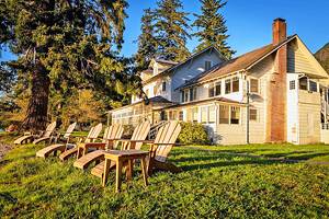
Where to Stay in Victoria
Luxury Hotels:
- For the quintessential Victoria experience, staying on the Inner Harbour is the best choice. This is where you'll find the landmark Fairmont Empress. This historical hotel oozes charm, elegance, and luxury.
- Across the harbor from the Empress is the Delta Hotels Victoria Ocean Pointe Resort. This modern hotel boasts rooms with incredible views, a well-respected restaurant, and is within walking distance of restaurants and shops.
- Those looking for a boutique luxury hotel for a romantic getaway or relaxing retreat will enjoy Abigail's Hotel. This adult-only property is set in a 1930s Tudor Mansion in a beautiful residential neighborhood, and only a 15-minute walk from the harbor area.
Mid-Range Hotels:
- Close to the harbor is the pet-friendly Huntingdon Manor, with a classic and elegant style that sets it apart from other properties in the area. You can choose from recently renovated standard rooms or two-story suites with lofts, and some rooms offer views of the harbor.
- The eco-conscious Hotel Rialto is a boutique hotel in a convenient location in the city center. Rooms come with mini-fridge and microwaves, and staff members are happy to help arrange tours and activities.
- If you are more interested in long walks along the seashore than exploring the harbor, the Oak Bay Beach Hotel is a good seaside option. This hotel is located near the trendy shops of Oak Bay and is noted for its mineral pools and amazing views out over the Juan de Fuca Strait.
Budget Hotels:
- Most of the budget hotels are back a bit from the Inner Harbour, however, this is not really a big issue as Victoria is a compact city, and nothing is much more than a 15-minute drive. With decent rooms and a good location, close to the harbor and near the Save On Memorial Arena, is the Capital City Center Hotel.
- The Days Inn by Wyndham Victoria Uptown is on the main bus route to downtown and has spacious rooms along with a pool and sauna.
- The Arbutus Inn is another decent budget hotel and close to an excellent assortment of restaurants.
Map of Hiking Trails near Victoria, BC
Victoria - Climate Chart
| Average minimum and maximum temperatures for Victoria, Canada in °C | |||||||||||
| J | F | M | A | M | J | J | A | S | O | N | D |
| 7 0 | 8 1 | 10 2 | 13 4 | 16 7 | 19 9 | 22 11 | 22 11 | 19 8 | 14 5 | 9 3 | 7 1 |
| PlanetWare.com | |||||||||||
| Average monthly precipitation totals for Victoria, Canada in mm. | |||||||||||
| 142 | 99 | 71 | 43 | 33 | 28 | 18 | 23 | 36 | 74 | 140 | 152 |
| Average monthly snowfall totals for Victoria, Canada in cm. | |||||||||||
| 17 | 8 | 4 | 0 | 0 | 0 | 0 | 0 | 0 | 0 | 3 | 15 |
| Average minimum and maximum temperatures for Victoria, Canada in °F | |||||||||||
| J | F | M | A | M | J | J | A | S | O | N | D |
| 43 32 | 47 34 | 50 35 | 55 38 | 61 43 | 66 48 | 71 51 | 71 51 | 66 47 | 57 41 | 48 36 | 44 33 |
| PlanetWare.com | |||||||||||
| Average monthly precipitation totals for Victoria, Canada in inches. | |||||||||||
| 5.6 | 3.9 | 2.8 | 1.7 | 1.3 | 1.1 | 0.7 | 0.9 | 1.4 | 2.9 | 5.5 | 6.0 |
| Average monthly snowfall totals for Victoria, Canada in inches. | |||||||||||
| 6.8 | 3.2 | 1.5 | 0 | 0 | 0 | 0 | 0 | 0 | 0 | 1.3 | 5.7 |
More Related Articles on PlanetWare.com
Victoria: Explore this city in more detail with our guide to the top attractions in Victoria. Discover the outstanding museums, gardens, and architecture, and if you have time, head farther afield to see more of Vancouver Island.
Vancouver Island: You could spend weeks exploring this beautiful island from top to bottom. For a little inspiration on where to go and what to see, have a look through our article on the best of Vancouver Island. While many visitors arrive via Victoria, another popular gateway city with plenty of things to do is Nanaimo. On the west coast of Vancouver Island, don't miss the tourist town of Tofino, popular for surfing, hiking, whale watching, kayaking, and wildlife viewing.