Canada's Top 10 Attractions And Things To Do For Tourists

"We get to see the maple trees, maple sugar and the maple leaves. We got the biggest timber woods so tall ... In Canada, we get to see them all," goes the refrain of Raffi's famous Canadian children's song. And, in many ways, the lyrics hold true. In The Great White North, as it's commonly known, travelers can see vast maple forests alongside sky-scraping mountains, roaring waterfalls, and crystal-clear lakes. With all of its geographical and cultural diversity, however, it can be difficult to pick just a few places to see on a trip to this awe-inspiring country. Thankfully, we've done the hard work for you by selecting the 10 best destinations in Canada for tourists.
In the heart of winter in 2024, I embarked on a weeks-long road trip from Quebec City to Toronto, exploring everything in between. From there, I headed west to Banff National Park in Alberta. As exciting as it was to see some of Canada's most famous places, it goes without saying that there is so much more to discover within its borders. With this in mind, our list includes famous attractions from all over the map, including Canada's Pacific Northwest, the Arctic region, and the Maritimes.
Rideau Canal, Ottawa, Ontario
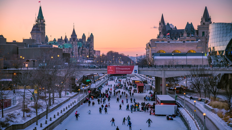
There may be no better place to begin your Canadian adventure than in the nation's capital. Located on the border of French-speaking Quebec and largely English-speaking Ontario, Ottawa can be considered the place where the country's linguistic cultures converge. The city blends regal European-style architecture with the skyscrapers typical of North America. And, you can experience it all on the Rideau Canal National Historic Site.
Recognized by UNESCO as a place of "outstanding universal value," the Rideau Canal first opened in 1832 as a transportation route for steam-powered boats and was considered one of the most fantastic engineering feats of its day. Approximately two centuries later, it still attracts a total of 2.4 million annual visitors, including both locals and tourists, with its array of unique year-round activities.
During the summer months, boat cruises run on the Rideau Canal, whisking visitors past Ottawa's most significant sights. Wintertime visitors, meanwhile, can ice skate on the Rideau Canal for free. Lauded as the world's largest skating rink, the Rideau Canal Skateway runs for 4.8 miles through the center of town, providing a popular way to travel through Ottawa's historic center. Ice skates are available for rent, as well as ice tricycles for adults, and sleighs or kick-sleds for the kids. When you're ready to refuel, hot chocolate and treat vendors are stationed right there on the ice. Just remember to layer up, as winter temperatures dive to -4 degrees Fahrenheit in Ottawa.
Green Gables Heritage Place, Prince Edward Island

The first line of Lucy Maud Montgomery's hit novel "Anne of Green Gables" describes a fictionalized version of her home in Avonlea, Prince Edward Island — "just where the Avonlea main road dipped down into a little hollow, fringed with alders and ladies' eardrops." If this sounds too magical to belong to anything but the world of fairy tales, think again. Located just 30 minutes from PEI's Charlottetown Airport (YYG), the Green Gables Heritage Place encapsulates the stunning white and green home that once inspired Montgomery's iconic work of Canadian fiction. Later used as the set of the "Anne of Green Gables" film, it now stands as an important symbol of Canadian culture.
Visitors say that the Green Gables Heritage Place feels just like stepping into Anne Shirley's enchanting world. Wander the farmhouse and barn, and snap a photo with the costumed actors dressed as the book's characters. Outdoors enthusiasts will definitely love the short hiking trails that wind through the picturesque back woods. Previous travelers especially applaud the "Lovers Lane" hike as scenic and easy to explore. You'll even find a re-creation of the fictional Avonlea Village, where trimmed houses and scrumptious eats abound. The heritage site opens every year in May and closes in October, which also happens to be the best time of year to visit this extraordinary island and surrounding Atlantic Coast provinces, including Nova Scotia and New Brunswick.
Old Montreal, Quebec
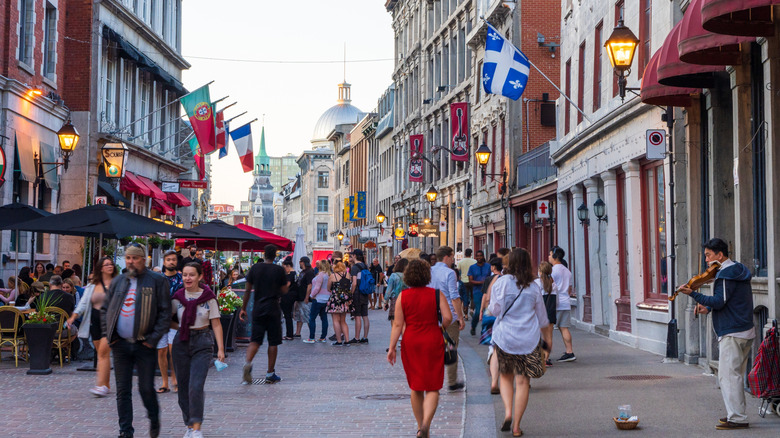
For a different kind of immersive experience, head to the old historic district of Montreal, Quebec. Old Montreal is widely considered the Paris of Canada, boasting cobblestone streets and buildings that date back to the city's founding in 1642. Old Montreal blends French Colonial and Romanesque Revival architecture to create an ambiance that feels distinctly European. Plus, French is the primary language in Quebec and is spoken by the vast majority of its residents. In practice, this means that travelers can visit Old Montreal's famous bakeries and order a croissant "en français."
To enjoy Montreal's history to the fullest, step inside the Gothic Revival Notre-Dame Basilica, which was built sometime around 1829. With its wide archways and towering statues, it exudes the grandeur of an ancient European cathedral. Previous visitors — myself included — recommend checking the events schedule for concerts and performances, as enjoying live music in this space can feel otherworldly.
The museum at Chateau Ramézay is another location that beckons visitors to explore a bygone era — in fact, experts deem it one of the world's top destinations worth seeing in your lifetime. Wander elegant rooms decorated with antiques and explore 500 years' worth of fascinating Canadian history. If all this exploration makes you hungry, head to the outdoor Marché Place Jaques-Cartier, a traditional old-school market with fresh produce, homemade goodies, and famous maple snow taffy in the winter.
Churchill, Manitoba
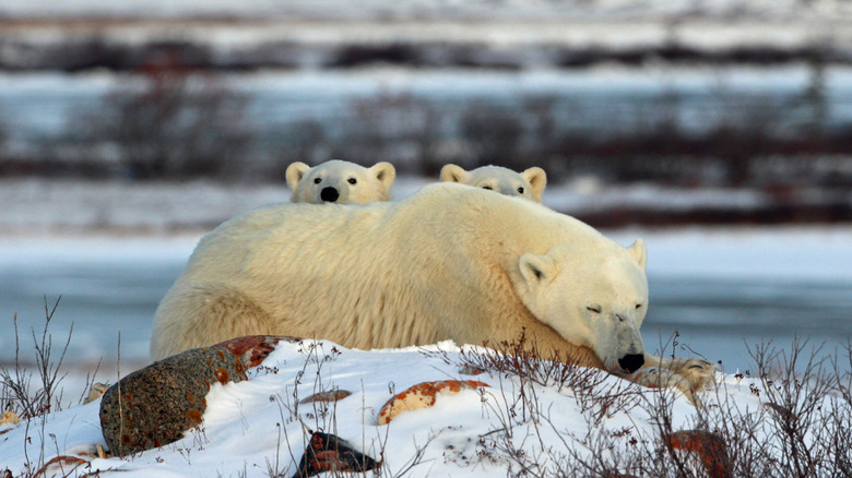
Beyond its big cities, Canada boasts some of the most awe-inspiring natural landscapes in the world. Chief among them is the tiny town of Churchill, Manitoba, a.k.a. the world's polar bear capital. Getting to Churchill can be an adventure on its own, with many visitors embarking on a two-day "Polar Express" inspired train journey from Winnipeg. Folks who have less time to make the trek can fly into the small — and often icy — Churchill Airport. Various tour companies, including Frontiers North Adventures, offer guided trips to see the polar bears. Hop onto a tundra buggy and get your camera ready — previous visitors say that seeing bears frolicking in the wild is unforgettable. Just remember that autumn is the best season for polar bear sightings.
Interestingly, polar bears are not the only majestic species that can be observed in the Churchill area — beluga whales also swim in the nearby Hudson Bay. To catch a glimpse of their Arctic white fins, visitors only need sign up for a whale watching boat tour. Folks who aren't afraid of Manitoba's frigid waters can also sign up for a kayaking experience in beluga territory. To maximize your chances of spotting these beautiful sea creatures, travel to Churchill in the summer. Many tour operators only take travelers into the Hudson Bay in July and August.
Niagara Falls, Ontario
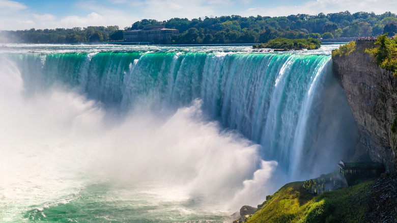
Take your Canadian adventures to new heights by visiting the crown jewel of its natural wonders: Niagara Falls. Situated just 90 minutes from Toronto by car, this beautiful waterfall allows visitors to admire the most voluminous falls in North America, all while exploring the vibrant surrounding city of the same name. Snap some photographs of Niagara Falls from the public view point, or splurge for the Journey Behind the Falls experience, which takes travelers to a special viewing platform down an elevator and into a cave. As the sun sets, enjoy dinner with a view at the Skylon Tower's revolving dining room. While the menu here may offer some pricey courses, previous diners say that the view of Niagara Falls from 775 feet high is spectacular.
Beyond the falls themselves, the Niagara Falls area is brimming with unique activities. Dare devils will love zip lining above the falls, the Mario Kart-style Niagara Speedway, and the 175-foot Niagara SkyWheel at Clifton Hill, Canada's very own mini Las Vegas. The falls are primarily considered a summer destination, but, take it from us — there are amazing things to do on a winter vacation to Niagara Falls, too. Locals recommend the Winter Festival of Lights, an enormous holiday lights display that transforms the city into a vibrant wonderland. Plus, seeing the falls freeze into giant icicles is truly out of this world.
Pacific Rim National Park, British Columbia
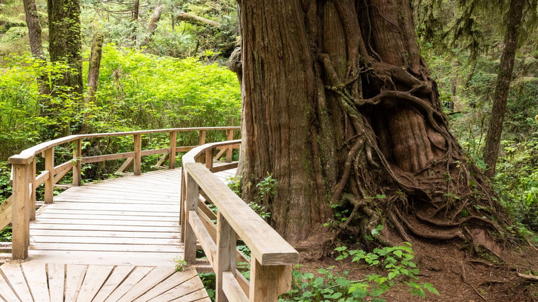
Canada may be known as a land of snow, but one of its regions is all about letting it rain — literally. Located in the province of British Columbia, the Pacific Rim National Park on Vancouver Island is known for its drizzling rain. Indeed, Vancouver Island's westernmost coast is home to a temperate rainforest that receives an impressive 98.5 inches of rain per year. To put that number into perspective, that's about three times the amount of rain that falls annually in Seattle, Washington. All of this water keeps the park's diverse plant life healthy and green. Large ferns, twisting arbutus trees, and rich moss grow across the region. To see it all, you can hike the park's famous Rainforest Trails.
Divided into Rainforest Trail A and Rainforest Trail B, each of these routes will guide visitors through .62 miles of emerald flora. While relatively short, these paths are considered moderately difficult to complete — no thanks to the combination of slick wooden boardwalks and steep stairways that keep travelers on their toes. That being said, the overwhelming majority of travelers say that these trails are beyond worth it. The gorgeous old-growth cedar and hemlock trees are a particular highlight, and some visitors report that the entire forest looks like the set of a Hollywood film. As an added bonus, the nearby town of Tofino, B.C. is home to some of the world's best beaches.
Yellowknife, Northwest Territories
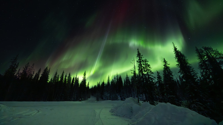
If you're in search of the best places to see the northern lights in North America, look no further than Yellowknife. Situated in the heart of the Northwest Territories, the city of Yellowknife offers unparalleled views of the aurora borealis. While many other parts of the world feature the northern lights sporadically, Yellowknife provides consistency. In fact, folks who spend three days in Yellowknife during the winter season (mid-November to early April) have a 98% chance of seeing the lights during their stay, according to Canadian Geographic. Yellowknife's clear night skies combined with its location beneath the "Auroral Oval" zone, where the lights are most active, create ideal conditions for nightly light shows.
Travelers rave about the beauty and visibility of the northern lights in this unique part of the world. By signing up for one of the local tours, travelers can spend an evening chasing the lights in a number of prime viewing locations. Just be sure to bundle up for the Northwest Territories' famous frigid temperatures — thermal layers are not only encouraged, but necessary here. The best way to get to Yellowknife is by flying into the Yellowknife Airport, although some travelers opt to make the scenic 19-hour drive from Edmonton, Alberta, traversing over 932 miles of wilderness.
Chateau Frontenac, Quebec
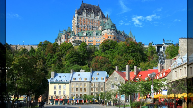
Europe may be home to some of Rick Steves' all-time favorite castles, but that doesn't mean that Canada lacks a palatial structure of its own. Constructed in the historic Francophone destination of Quebec City, Quebec in 1893, Chateau Frontenac stands as one of the most interesting castles in North America, nestled on Cape Diamond bluff overlooking the St. Lawrence River. Built as a hotel, Chateau Frontenac has housed its fair share of royalty over the years. Back in the early 20th century, it welcomed King George VI and Queen Elizabeth Bowles-Lyon of England, and later Queen Elizabeth II of England and Princess Grace of Monaco. This iconic structure was also used for political purposes. During World War II, Canada's then-prime minister, William Lyon Mackenzie King, would go to the castle to meet with British prime minister Winston Churchill and U.S. President Franklin Dr. Roosevelt.
Today, the landmark remains an iconic Canadian hotel, Fairmont Le Chateau Frontenac. Visitors from all over the world come for its timeless elegance, historic suites, and afternoon tea. A National Historic Site of Canada, the hotel offers tours that would enthrall just about any history lover. Beyond the castle's walls is the Historic District of Old Quebec, a stunningly-preserved fortified town and UNESCO World Heritage site, with narrow cobblestone streets and charming shops around every corner.
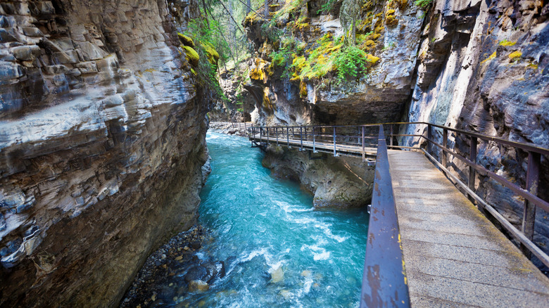
Banff National Park, Alberta
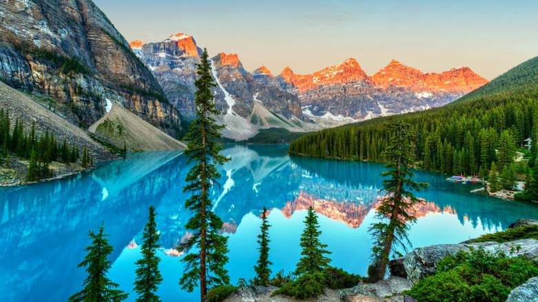
To experience Canadian nature at its finest, head to Banff National park in the province of Alberta. This stunning region encapsulates the dramatic peaks of the Canadian Rocky Mountains, as well as the glacial lakes of Lake Louise and Emerald Lake. The result is postcard-perfect scenery that marries snow-capped mountains with turquoise waters. It's no wonder that this region became Canada's first national park back in 1885, and remains one of the most photographed destinations on Earth.
The best part about Banff National Park is that it really is a year-round destination. During the summer months, travelers can rent canoes and paddle across Lake Louise's stunning surface. Hikers will surely enjoy one of the many trails that snake through the mountains. A seasonal favorite is the Tea House hikes, with trails up to two historic tea houses to enjoy a cuppa with a view.
While canoeing and hiking are not possible in the wintertime, there's plenty to do at Banff National Park in the colder months. For example, ice skating on Lake Louise is a beloved winter pastime. Or, if you'd prefer to stay on land, kick on some snowshoes and trek from one side of the lake to the other. Downhill skiers will be happy to know that Banff Sunshine Village has one of the highest lift-served slopes in all of Canada, and Lake Louise Ski Resort isn't far behind.
Ripley's Aquarium and Royal Ontario Museum, Toronto, Ontario
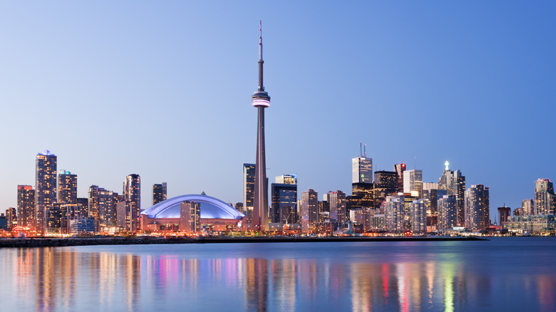
Canada boasts rich cultural centers full of fabulous educational value, and residents of Toronto, Ontario know it. As Canada's biggest city, Toronto offers a variety of world-class attractions for visitors of all ages. Ripley's Aquarium of Canada is among the best aquariums in North America, thanks to its collection of 20,000 aquatic animals. The aquarium is also home to the continent's longest underwater observation tunnel, where you can stroll among majestic sharks. The aquarium hosts all kinds of events in the underwater tunnel, including romantic Valentine's Day dinners among the sharks.
Land lubbers, meanwhile, will love the Toronto Zoo, one of the world's most diverse zoos, located northeast of downtown. The institution is home to 300 different species, ranging from sloths to cheetahs to gorillas. The Toronto Zoo is an amazing place to travel with small children, and is surrounded by the vast Rouge National Urban Park. "One of the best and most beautiful zoos I've ever visited," reads one review on Tripadvisor. "The variety of species is wide and the animals have plenty of space, making the experience more enjoyable [...] It is an ideal setting to enjoy a full family day, combining fun, nature and learning on each tour."
Back in the city, the Royal Ontario Museum (ROM) is a trove of natural history exhibits, artwork, and ancient artifacts. The museum's collection includes a whopping 18 million pieces across 40 gallery spaces. Gaze up at the largest dinosaur in Canada, admire the bust of Cleopatra, and examine the armor of the Earl of Pembroke. At the ROM, everything seems possible. Ticket prices vary, but on the third Tuesday night of every month, entrance to the museum is free.
Methodology
Creating a list of the 10 best attractions in Canada is no easy feat, but we thoroughly enjoyed the challenge. For this list, we used reputable travel publications, local tourism boards, and reviews from trusted platforms like Tripadvisor for guidance. We tried to highlight the key aspects of Canada's incredible diversity, ranging from the urban cultural offerings in Toronto to the wildlife of Churchill, Manitoba. While the Green Gables Heritage Place represents an ode to Canadian literature, the Old Montreal and the Chateau Frontenac in Quebec City stand as two of the most significant historical sites in Canada.
For us, it was essential to showcase Canada's geographical diversity, including the temperate coastal rainforests of British Columbia and the aurora borealis in the Northwest Territories, one of the quintessential experiences of the Great White North. Meanwhile, the Rideau Canal and Niagara Falls represent two of Canada's most famous waterways and tourist landmarks. While many remarkable destinations could have been featured, this selection highlights the most reviewed and most renowned throughout history and across generations.