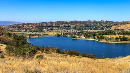
10 Best Campgrounds near Moab: Arches, Canyonlands, Dead Horse Point, BLM, & More

Written by Lana Law
Updated Mar 21, 2023
We may earn a commission from affiliate links ()

Camping around Moab is spectacular, with scenery that ranges from mountains and canyons to slickrock and rivers. Some of the best options for campgrounds in this part of Utah include nearby Arches and Canyonlands National Parks, recreation sites, campgrounds operated by the Bureau of Land Management (BLM campgrounds), and private parks right in the town of Moab.

Arches National Park, Devils Garden Campground
Arches National Park, Devils Garden Campground | Photo Copyright: Lana Law

Apart from the larger RV campgrounds in Moab, most campgrounds are small, with 20 to 30 individual campsites or less. Some of these are tent campgrounds only, others are open to both tents and RVs.

BLM sites are primarily first-come, first-served, with the exception of group campsites. Some of the national park campsites, and certainly private campgrounds, are reservable and should be booked well in advance.

Where you decide to camp may depend on the type of things you want to do near Moab, whether it is rafting, biking, ATVing, hiking, or simply sightseeing in the area.

To sort through the possibilities, see our guide to the best campgrounds in Moab.

1. Arches National Park: Devils Garden Campground

Arches National Park: Devils Garden Campground
Arches National Park: Devils Garden Campground | Photo Copyright: Lana Law

The Devils Garden Campground is the only campground in Arches National Park, and the setting here is beautiful. The campsites are excellent, with almost all of them well spaced and offering a high degree of privacy.

Most of the campsites are set around large rock formations and a scattering of juniper and pinyon pines that provide protection from wind and offer some shade. A few, particularly along the east side of the campground (sites 18, 20, 21, 23, and 24) have spectacular views to the mountains, although they are more exposed and offer less shelter from the elements. The maximum RV size permitted is 40 feet, but take note when booking that many of the sites are smaller and will only fit an RV of 20 feet or less.

Getting one of the 51 campsites can be challenging without some pre-trip planning. During the high season of March 1 to October 31, sites are reservable and book out months in advance. You can reserve a campsite 180 days in advance, but from November 1 to February 28, when temperatures are cold, the campground is first-come, first-served.

The Devils Garden Campground is at an elevation of over 5,000 feet, giving it a slightly different climate than in Moab. Nights up here can be cool, particularly in spring and fall, but quite pleasant during the summer heat.

Arches National Park - Layout map
Arches National Park Map (Historical)

2. Canyonlands National Park, Island in the Sky District: Willow Flats Campground

Canyonlands National Park, Island in the Sky District: Willow Flats Campground
Canyonlands National Park, Island in the Sky District: Willow Flats Campground | Photo Copyright: Lana Law

Willow Flats is the only campground in the Island in the Sky district of Canyonlands National Park. Unlike Arches National Park, this campground is first-come, first-served and sees many tenters.

The campground is near the Green River Overlook, and while there are no good views from the actual campsites, it is just a short stroll to a wonderful lookout over a canyon, towards sheer cliff walls in the distance. There is also a large group fire ring that looks out over this view.

The campsites are very well spaced and heavily treed. However, the trees are relatively small and do not offer much shade, but each campsite has a picnic table with a shelter.

This area can accommodate tents or RVs up to 28 feet, with paved parking pads and plenty of space for tents. With only 12 campsites, competition is high, and the campground usually fills up daily from March until June and from early September to mid-October.

The elevation here is quite high and temperatures can be cooler than in Moab.

No drinking water is available at this campground, but a tap is located at the visitor center.

Official site: https://www.nps.gov/cany/planyourvisit/camp-isky.htm

Canyonlands NP & Glen Canyon - Map
Canyonlands NP & Glen Canyon Map (Historical)

3. Dead Horse Point State Park: Kayenta Campground

Dead Horse Point State Park Overlook
Dead Horse Point State Park Overlook | Photo Copyright: Lana Law

The Kayenta campground at Dead Horse Point State Park has 21 sites, all of which are quite well spaced and offer some privacy. Campsites vary in size and are open to both tents and RVs.

The sites provide lighted shade structures, picnic tables, tent pads, and fire rings. This campground has electrical hookups (20/30/50 amp) and flush toilets.

Reservations can be made four months in advance of your stay and are accepted year-round. For prices, see the park's website.

The West Rim trail and East Rim trail leave from the campground area, making it a good option for hikers.

4. Canyonlands National Park, The Needles District: Needles Campground

Canyonlands National Park, The Needles District: Squaw Flat Campground
Canyonlands National Park, The Needles District: Squaw Flat Campground | Photo Copyright: Lana Law

The Needles Campground, formerly known as Squaw Flat Campground, is actually two campgrounds divided into "A" and "B," and together they have a total of 26 campsites. Most of the best sites are in "A," the larger of the two areas, where there are views out over the landscape and large spacing between sites. That said, campground "B" is set around a few large rock formations, sites are large, and it is also very pleasant.

About 12 sites in Loop B are reservable during peak times; Loop A is always on a first-come, first-served basis. Sites accommodate both tents or RVs up to 28 feet; five sites are exclusively for tents.

Camping here can be a real advantage if you are planning on hiking in the remote Needles area. Many of the hiking trails are long and take a full day, and you can get an early start from the campground, rather than having to drive all the way in from a campground outside the park, or the two hours from Moab. If you are doing multiple days of hiking, staying here will save you a great deal of time commuting back and forth.

5. Sand Flats Recreation Area

Sand Flats Recreation Area
Sand Flats Recreation Area | Photo Copyright: Lana Law

Sand Flats Recreation Area is a playground for jeeps, ATVs, dirt bikes, and mountain biking. This is where the famous Slickrock Mountain Bike Trail is located, but the road extends far beyond the biking trail, into a world of slickrock dunes and rolling rock hills.

Scattered along this road are nine small campgrounds with campsites for both tents and RVs. In total, there are 140 campsites; RV owners take note that only 30 sites are suitable for RVs up to 40 feet. No RVs over 40 feet are allowed. Those choosing to camp in RVs should focus their search for sites in the following campgrounds: Alcove (A), Bobcat (B), Echo (E), and Juniper.

Just past the entrance to the recreation site, near the Slickrock Bike Trail, is a small, surreal-looking campground area, where RVs park right on the barren slickrock. Beyond the bike trail, the nine campgrounds are mainly patches of dirt and sand between the rock hills, spread out at sporadic intervals over more than 10 miles along the road.

The road eventually leads out of the slickrock into more of a dirt and rubble landscape, with canyons and mountains all around. The Porcupine Rim Trail (both the RV and bike trail) begins on this road. This is a great place to camp if you are here to go ATVing or dirt bike riding, with trails leaving right from some of the camping areas.

The 140 sites are all non-reservable and first-come, first-served. During the high season of spring and fall, these sites fill up on the weekends, beginning on Thursdays. The campgrounds have vault toilets, fire rings, and picnic tables. RV campers should be prepared to boondock.

Official site: https://www.grandcountyutah.net/289/Camping

6. Campgrounds along the Colorado River

Campgrounds along the Colorado River
Campgrounds along the Colorado River | Photo Copyright: Lana Law

Heading east out of Moab on Highway 128 are a series of campgrounds along the Colorado River, which at this location is hemmed in by dramatic sheer cliff walls that make for a stunning setting. The narrow, twisting highway runs along the south side of the river, and the campsites are right off the road.

These campgrounds are all operated by the Bureau of Land Management (BLM), and sites are available on a first-come, first-served basis. There is a nightly fee, and all of the campgrounds have toilets.

If you are here to enjoy the river, kayaking, canoeing, rafting, or boating, these campgrounds are incredibly convenient. This area is also near the trailhead for the Negro Bill Canyon hiking trail and the terminus of the Porcupine Rim biking trail.

Heading East on Highway 128

About two miles outside of Moab along Highway 128 is Goose Island Campground, open to both tents and RVs. The area has good shade in the summer and a paved bike trail that runs from the campground along the river into the town of Moab.

Just a short drive further out, across the highway from the Negro Bill Canyon trailhead and where the Porcupine Rim Trail joins Highway 128 is the Granstaff Campground, with smaller sites for tent camping.

About five miles farther on is the Hal Canyon Campground, with 11 small sites suited for tents; two of these are walk-in sites. Adjacent to this campground is Oak Grove Campground, with seven tent-only sites, four of which are walk-in sites. Next to this is Big Bend Campground, with a sandy beach and 23 sites for both tents and RVs. Many of these are beautiful riverfront sites with great views.

There are campgrounds further out as well, including Hittle Bottom, Onion Creek, and Fisher Towers, but these are more than 20 miles from Moab. These are good fallbacks if the others are full and they are convenient for hikers wanting to walk the Fisher Towers Trail. Onion Creek has a corral area for horses.

7. Campgrounds on the Road to Canyonlands, Island in the Sky District: Horsethief, Cowboy, and Lone Mesa Campgrounds

Horsethief Campground
Horsethief Campground | Photo Copyright: Lana Law

There are three campground areas on the road leading into the Islands in the Sky district of Canyonlands National Park, all of which are under the control of the Bureau of Land Management. The Visitor Center at Canyonlands National Park provides information on these campgrounds but is not responsible for bookings.

The main campground that will be of interest to most people is the Horsethief Campground. This is a large, non-reservable campground that accommodates both tents and RVs and is very close to some popular biking trails.

Almost across the highway from this campground are the Horsethief Area biking trails, including the Magnificent 7 trailhead. Walking trails also leave from this campground, and the Gemini Bridges Road is nearby, on the opposite side of the highway.

Also on the road to Canyonlands is the small Cowboy Campground, with only seven sites for tents only. This is a quiet campground set on a rise, with good views over the surrounding area but quite exposed to the wind and elements.

Nearby, Lone Mesa is a campground specifically for groups, and group bookings are accepted. However, there is a schedule of groups posted at the entrance, and if there is no one booked for group camping, anyone can camp here. This campground is mainly just a large parking pad but it's great for RVs. It is also very close to the Navajo Rocks biking area trailhead.

8. Campgrounds and RV Parks in the Town of Moab

Campgrounds and RV Parks in the Town of Moab
Campgrounds and RV Parks in the Town of Moab | Photo Copyright: Lana Law

Moab has several RV Campgrounds. Some of these are in town and within walking distance of the main street, and some are farther out but a short drive from town.

Moab is not that big, and since most RV campers are self-sufficient and not necessarily looking to be close to restaurants and shops, all of the campgrounds are good.

It may come down to which campground is available during your stay. Be sure to book in advance, particularly in high season, when the campgrounds are typically booked out in advance. Some of these parks include the Sun Outdoors Arches Gateway (formerly Moab Valley RV Resort & Campground, Sun Outdoors Moab Downtown (formerly Canyonlands RV Resort and Campground), Portal RV Resort, and Slickrock Campground. Several others are located just south of Moab.

9. Needles Overlook Area Camping

Needles Overlook
Needles Overlook | Photo Copyright: Lana Law

The Needles Overlook is south of Moab. The turnoff for this area is between the town and the road leading to The Needles district of Canyonlands National Park and is marked with a sign on the highway.

This road leading out to the Needles Overlook splits, and a gravel road leads out to the Anticline Overlook, while the main road continues on to the Needles Overlook. These lookouts are spectacular, and since they are at least 20 minutes off the main highway, they do not receive the type of traffic seen in the park.

On the gravel road leading out to the Anticline Overlook is the Hatch Point Campground, set on a mesa with views of the surrounding area. This is a BLM campground with a flush toilet, no potable water, and 10 campsites.

If you are exploring the Needles Overlook area, you will notice that there are, what appears to be, campsites off the left side of the road, just a few minutes before you reach the Overlook. Stone fire pits and open spaces are in spectacular cliff-side locations here that look tempting. However, these are undesignated campsites and it is not a BLM campground.

10. Dispersed Camping near Moab

Castleton Tower, Moab

If you really want to get away from it all or don't want to pay a fee to camp, then give some thought to exploring the dispersed camping options near Moab. Out here, you'll be among like-minded individuals enjoying nature in spectacular settings. Some of the best sites are in the Manti-La Sal National Forest.

Seven different areas are available: La Sal Loop Road (lots of options & quiet), Castleton Tower (busy and oriented towards climbers), Willow Springs Road (close to Arches), Yellow Circle Road (good roads), Gemini Bridges Road, Klondike Bluffs Road, and Long Canyon Road. Note that the Gemini Bridges Road is very rough and not suitable for anything except a 4WD.

In some areas, you'll find actual designated campsites, and in other areas, it's wide open for you to find your perfect spot.

Map of Campgrounds near Moab: Arches, Canyonlands, Dead Horse Point, BLM, & More

Moab, UT - Climate Chart

Average minimum and maximum temperatures for Moab, UT in °C
JFMAMJJASOND
6 -7 12 -3 18 2 23 6 29 10 35 14 38 18 37 17 32 12 24 5 14 -1 8 -6
Average monthly precipitation totals for Moab, UT in mm.
17 13 23 25 21 9 23 21 19 32 20 16
Average minimum and maximum temperatures for Moab, UT in °F
JFMAMJJASOND
43 20 53 26 64 35 73 42 84 50 95 58 101 64 98 63 89 53 75 41 57 30 46 21
Average monthly precipitation totals for Moab, UT in inches.
0.7 0.5 0.9 1.0 0.8 0.4 0.9 0.8 0.8 1.3 0.8 0.6