Virginia's 11 Must-See Destinations For Your First Visit
In 1969, advertising agency Martin & Woltz devised one of the most famous tourist slogans in recent memory: "Virginia Is for Lovers." As Virginia Tourism grappled with trying to get younger travelers to the state, the campaign kicked visits into high gear and has endured ever since. Around the state, you can find more than 300 "LOVEworks" — photo-worthy tributes to the slogan at Virginia's beaches, food joints, parks, farms, landmarks, and more. Of course, the famous tagline is just the beginning of what this memorable state has to offer.
A record number of former U.S. presidents hailed from Virginia — eight total, including four of the first five. Two grand estates that belonged to George Washington and Thomas Jefferson are among the state's top attractions, and you'll also find plenty of military history here, where more battles were fought than in any other state during the Civil War. In addition to gorgeous scenic areas like George Washington and Jefferson National Forests and Shenandoah National Park, Virginia also boasts the most miles of any state through which the Appalachian Trail passes — 544, to be exact. While on the trail, be sure to check out Narrows, a postcard-perfect town with endless outdoor adventure. Whether you're a history hound, a beach bum, a scenic drive-seeker, or anything in between, here are 10 must-see destinations for your first visit to Virginia.
Shenandoah National Park and Skyline Drive
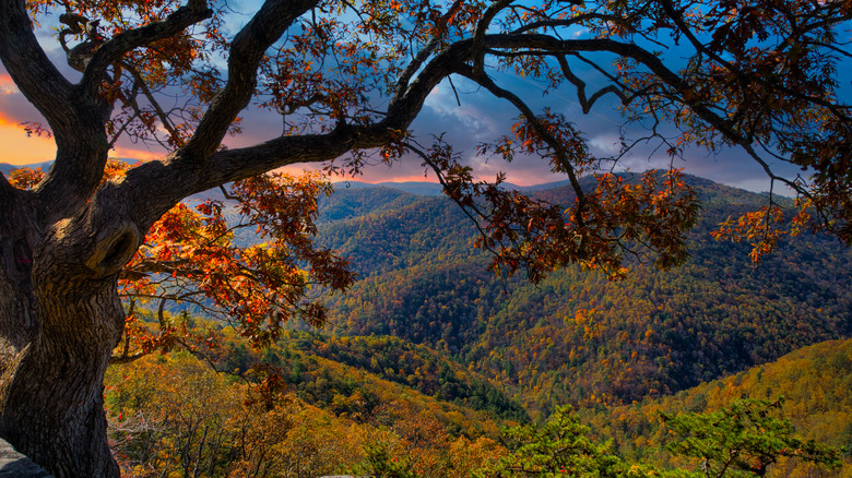
It turns out that one of the U.S.' most accessible national parks is a slice of scenic paradise in Virginia — none other than Shenandoah National Park. It's easy to get to from major hubs like Washington, D.C., from which it's only about a 1.5-hour drive to the Front Royal entrance in the north. The distance is similar from Richmond, Virginia, to the southern entrance of the park near Waynesboro. From both places, you'll immediately have access to the famous Skyline Drive, which meanders for 105 miles through the length of the park and provides your starting point for most hiking trails.
Dog owners will be happy to learn that Fido will also be able to enjoy the vast majority of Shenandoah National Park. It happens to be one of the most dog-friendly national parks in America, according to reviews. Find more than 500 miles of hiking trails throughout the park, where dogs are prohibited on only about 20 cumulative miles. Experiencing nature is what Shenandoah is all about, and the hike up Old Rag Mountain will get your heart pumping and reward you with panoramic views from the summit. Then, scale the park's tallest peak, Hawksbill Mountain, from mile 41.7 along Skyline Drive. It's only about 2 miles out-and-back, but it can get busy during weekends and in the summer. "Beautiful views at the top," one visitor wrote in an Alltrails review. "Arrive early for parking and less crowds," they add.
Colonial Williamsburg
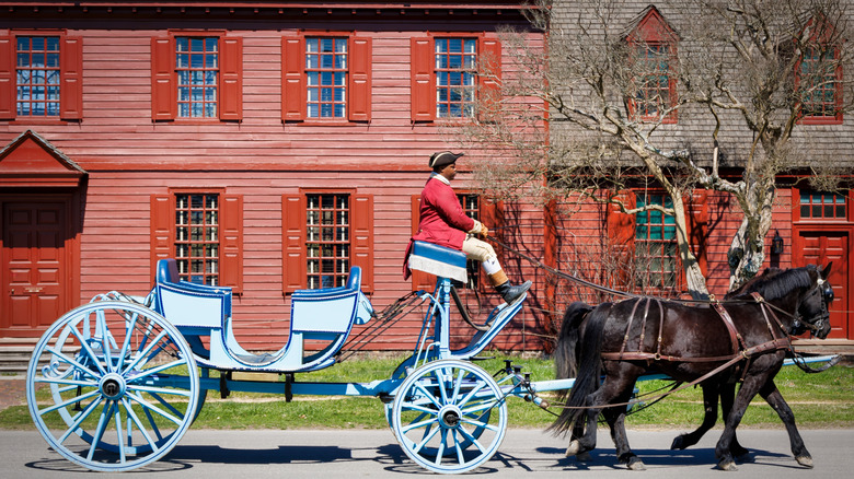
A little less than an hour's drive southeast of Richmond, you'll find a huge, immersive museum that spans 301 acres: Colonial Williamsburg. Open every day of the year, it offers virtually endless opportunities to experience what life was like for people during the American Revolution of the 18th century. Learn about the movers and shakers who built America, the local Indigenous tribes who inhabited the land long before settlers arrived, stories of Black Americans in historical Williamsburg, and the often undocumented experiences of women during this time. As of this writing, single-day admission is $35 per adult, and $10 for kids aged 6 to 12. Multi-day tickets or annual passes are a great deal if you plan to spend more than one or two days here.
Colonial Williamsburg's Historic Area contains 89 authentic 18th-century buildings, and the park includes more than 300 structures total. Many have been painstakingly built based on archival or archaeological evidence, inviting you into working taverns, workshops for more than 20 trades, more than two-dozen gardens, and colonial houses. The museum's website lists which buildings will be open on certain days and notes whether you can take a self-guided stroll or need to join a guided tour to see certain places. One tip for walking around the park is to look for what's known as the Grand Union flag — the first American flag adopted while still under British rule in 1775 — which waves in front of buildings that are open. Along with your choice of several on-site inns and hotels, you can immerse yourself in history and stay overnight in one of the recreated colonial-era houses or tavern rooms, complete with 18th-century furnishings.
Virginia Beach
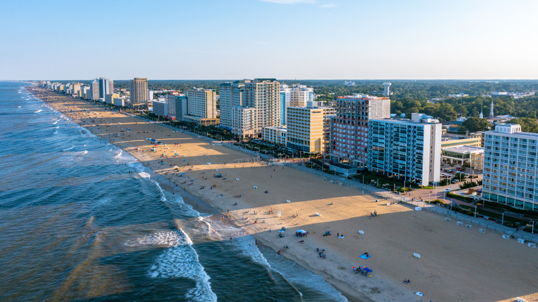
Just about 20 minutes east of Norfolk, golden sand and wide-open Atlantic Ocean vistas await in the busy tourist town of Virginia Beach. Known for its approximately 35-mile-long Oceanfront Beach, this summertime hub is a huge attraction for its boardwalk, which is lined with restaurants and shops. Learn to surf at WRV Surf Camp or VB Surf Sessions, the latter of which also offers stand-up boards and surfboards for rent along with beachy must-haves like umbrellas, chairs, and coolers.
If you're looking for a different type of aqua adventure, whisk the kids to Ocean Breeze Waterpark, which includes both gentle and thrilling waterslides. Then, head to the Virginia Aquarium & Marine Science Center to dive into the science of marine life. Daily keeper talks provide fascinating insights about the marine animals. Seasonal whale and dolphin watching cruises are an opportunity to see ocean life in the wild. And for a slightly different take on wildlife, head to the Atlantic Waterfowl Heritage Museum, located in a historic waterfront home, which highlights the art of decoy carving and conservation efforts.
When it comes to habitat conservation, Back Bay National Wildlife Refuge is an oasis of dunes, shoreline, marshes, and forest located just south of town. Walk along more than 8 miles of trails and keep an eye out for tundra swans, ducks, loggerhead sea turtles, and more. North of Virginia Beach, climb the Old Cape Henry Lighthouse, built in 1792 as the first construction project of the brand new United States, which requires entering the Fort Story military base and taking a shuttle — however, if you carry a military ID, you can drive there directly.
Arlington National Cemetery

On a hill overlooking the Potomac River and Washington, D.C., Arlington National Cemetery is a solemn and deeply historic site. Its most famous memorial is the Tomb of the Unknown Soldier, a marble sarcophagus built in 1921 in honor of the unidentified soldiers who fought in World War I. Throughout the decades, the remains of unknown service members from World War II, the Korean War, and the Vietnam War have also been laid to rest here, and it's protected around the clock by soldiers of the 3rd U.S. Infantry Regiment, also known as "The Old Guard," who continuously perform an elaborate and symbolic routine. Watch the ceremonial changing of the guard every half-hour between April and September, and every hour between October and March. The cemetery is open daily from 8 a.m. to 5 p.m.
Arlington National Cemetery is enormous, spanning nearly 700 acres of rolling terrain, containing nearly 430,000 graves, and interspersed with historic buildings and memorials. Tram tours are a great way to get around, operating every 20 minutes and stopping at the most iconic tombs and landmarks, like President John F. Kennedy's gravesite, Arlington House, and the Memorial Amphitheater — where you'll find the Tomb of the Unknown Soldier. Additional stops are added to the route during the weekend. The cemetery is very active, performing at least 20 funeral services per day, and those events can sometimes affect tram routes or access to certain roads and walkways. If you're looking for a particular gravesite, download an app called ANC Explorer, which provides directions to specific headstones and landmarks.
Mount Vernon
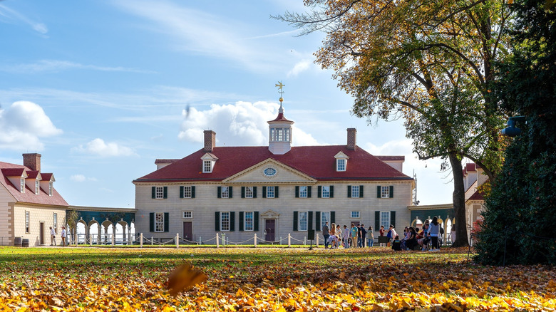
Part historic estate and part living history museum, Mount Vernon is a must for those interested in U.S. presidential history, colonial architecture, and America during its earliest years as an independent nation. The 18th-century home and farm belonged to George and Martha Washington, who are also buried here, and a visit will guide you around the mansion, a number of outbuildings designated for trades like blacksmithing and fiber spinning, gardens, and museum exhibits. Just down the road, you can even visit a fully-functional reconstruction of Washington's distillery and gristmill. Then, pop into the Mount Vernon Inn Restaurant for a meal with 18th-century ambience.
Washington ran Mount Vernon from 1754 until his death in 1799. The working farm is a treat to experience — a miniature recreation of the first president's 3,000-acre version, where interpreters in period costume demonstrate some of Washington's trailblazing agricultural ideas. Here, you can visit a uniquely charming 16-sided barn.
Deeply entwined with the history of the Mount Vernon estate were the hundreds of enslaved people who kept the 21-room house clean and maintained, were trained in specific trades, and tended to the grounds. Along with information about daily life for the Washington family, learn about the unknown men, women, and children who played a crucial role in keeping Mount Vernon running, from weaving fine textiles to smoking meat in the estate's smokehouse.
Jamestown and Yorktown

In late December 1606, three ships carrying just over 100 English settlers arrived in North America from London, ready to establish a colony on the long coastline then known as Virginia. On April 26, the ships sailed into Chesapeake Bay, and three days later, a cross put up on Cape Henry declared the area to be under British control. And in mid-May, the very first permanent English settlement was declared "James Cittie" — now known as Jamestown. Today, Colonial National Historical Park encompasses the area where the settlement originally stood. While only archaeological fragments remain, excavations continue into the rich and layered history of the site. Today, you can visit the open-air museum staffed by costumed interpreters who bring the reconstructed fort to life.
Colonial National Historical Park also encompasses colonial Yorktown, where the last crucial battle of the American Revolutionary War took place in 1781. A successful settlement by the 1700s, it was a thriving and strategic port. During the later part of the war, the British used it as a naval base, but the fighting largely destroyed the town. Today, Yorktown still features notable remnants of its colonial past, including the Nelson House and the Customhouse, both on Main Street, and the reconstructed Swan Tavern. For a scenic drive through the 17th and 18th centuries, cruise along the Colonial Parkway, a storied route that travels between some of America's most significant historic sites. The parkway stretches 23 miles and triangulates between Yorktown, Jamestown, and Williamsburg.
Monticello and Charlottesville
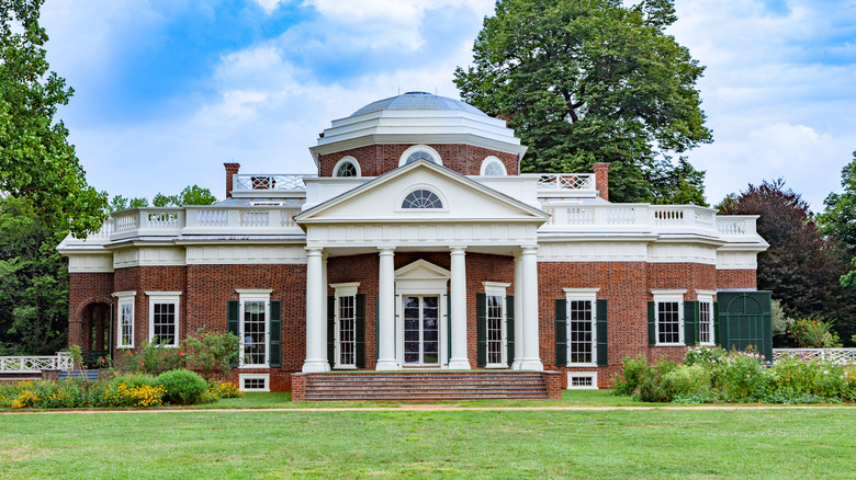
Perhaps unsurprising for a state from which four of the first five U.S. presidents hailed, Virginia has no shortage of historic homes and estates from the 18th and 19th centuries. Thomas Jefferson, the country's third president, resided at an elegant estate called Monticello. Located on the southeast edge of Charlottesville, this sprawling destination is a glimpse back at the life of an ambitious figure who is renowned as the author of the Declaration of Independence. The mansion contains 33 rooms, with more in adjacent structures, and it's surrounded by ornamental gardens, a vegetable garden, and an orchard. A variety of tickets are available for different tours and experiences, some of which hit the highlights and others that go behind the scenes or focus on specific historical facets, like women at Monticello or the realities of slavery.
At 76 years old, Jefferson also began working toward the founding of the prestigious University of Virginia in Charlottesville, which was chartered in 1819 and opened a year before his death in 1825. The progressive project was a new way of thinking about education in America, focusing on the potential of individuals to contribute to the country's newly minted democratic society. The campus is a joy to wander around, with its neoclassical Jefferson-designed buildings around a picturesque lawn in the U-shaped Academical Village. And on the topic of charming places to walk, downtown Charlottesville's historic mall on Main Street is a brick-paved pedestrian thoroughfare complete with dozens of shops, restaurants, and a vintage movie theater. The surrounding region is also a popular wine destination, where you can drop in for a tasting, meal, or a tour at estates like King Family Vineyards, Pippin Hill Farm & Vineyards, Oakencroft Farm & Winery, and more.
Manassas National Battlefield
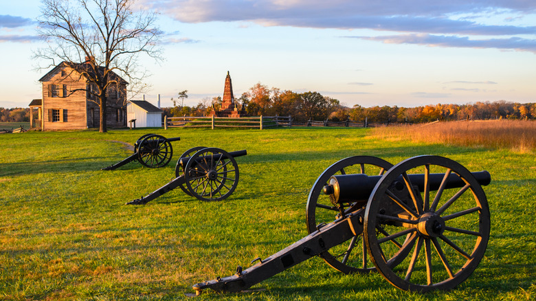
During the Civil War, Virginia found itself at the heart of the action, making it the most battled-in state. Add to those the numerous battles that took place during the Revolutionary War a few decades earlier, and Virginia is home to dozens of battlegrounds worth a visit. One particularly famous Civil War site, which is now preserved as a national historical park, is an area called Manassas, which overlooks a stream called Bull Run.
Today, Manassas is a picturesque city with a giant farmer's market less than an hour from D.C. But in 1861, this was where the inaugural battle of the Civil War, known as the First Bull Run, commenced at 2:30 a.m. on July 21, as the Union Army attacked Confederate forces. Around 12 hours later, the Confederates had secured a decisive victory, and it was clear that the war would not be quickly concluded. In August of the following year, a second battle here also ended with a significant victory for the Confederates.
Today, Manassas National Battlefield Park offers fantastic hiking opportunities on 40 miles of trails. Developed paths with interpretive panels lead visitors on a journey through the events and military maneuvers that characterize the area. Visit the Henry Hill Visitor Center and the Brawner Farm Interpretive Center for information about getting around, special exhibits, and educational programs. You can also visit a reconstruction of a historic blacksmith shop owned by a freed former slave named Andrew Redman.
Chincoteague and Assateague Islands
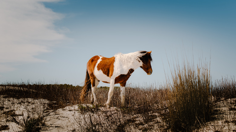
Assateague Island, a 37-mile-long barrier island that spans between Virginia and Maryland, is a stunning natural landscape with pristine beaches, marshes, woodlands, and bays. The entire island comprises the Assateague Island National Seashore, which is predominantly undeveloped so that wildlife and its diverse habitats can flourish. A lobe off the southern end has also been designated as the Chincoteague National Wildlife Refuge.
Chincoteague National Wildlife Refuge has opening times that vary by season, and the Assateague coastline is open year-round. Both are magnets for birdwatchers and wildlife enthusiasts, especially those keeping an eye out for seals, migrating birds, and the island's famed equine residents — the wild descendants of domesticated horses that colonists first brought to the island around three centuries ago. One great place to keep an eye out for them is along the 1.6-mile Woodland Trail, which features a scenic overlook.
Assateague Island protects another inner island called Chincoteague Island, Virginia's only resort island and home to the community of Chincoteague — a great basecamp for exploring the nature refuges' trails and beaches. History is everywhere in this coastal oasis, like the charming gem of the Captain Timothy Hill House, the oldest house on the island with mysterious timber ship carvings etched into its walls.
The Steven F. Udvar-Hazy Center
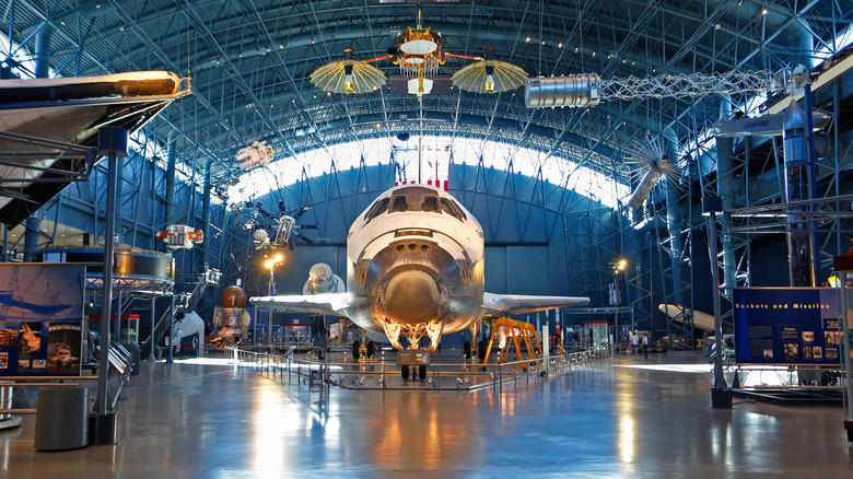
Located in Chantilly, Virginia, just about 40 minutes west of Washington, D.C., the Steven F. Udvar-Hazy Center is a marvel of aeronautic history and engineering. This is an amazing place to explore historic planes and spacecraft for free as part of the Smithsonian Institution family of museums. The Steven F. Udvar-Hazy's Center's sibling museum is the National Air and Space Museum, which is situated on the National Mall in D.C.
In Chantilly, two colossal hangars are home to more than 200 aviation artifacts, including the Space Shuttle Discovery and the Lockheed SR-71 Blackbird, a Cold War-era stealth jet that can travel at three times the speed of sound. Admire the world's smallest airplane that a person can sit in, the 1903 Wright Flyer designed by aviation pioneers Wilbur and Orville Wright, and even a "Star Trek" Starship Enterprise studio model along with more than 3,000 other artifacts.
Petersburg National Battlefield
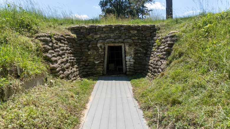
Petersburg National Battlefield, located on the outskirts of modern-day Petersburg, is the poignant site of the longest battle of the entire Civil War. Lasting more than nine months between June 1864 and April 1865, the siege took the lives of around 70,000 soldiers. The innovative yet deplorable conditions of trench warfare meant that soldiers suffered both physically and psychologically. The park comprises 13 different sites where entrenchment and battles occurred, which you can access via a 33-mile driving route that also leads you to three visitor centers. Ultimately, the Union Army took the hard-won victory at Petersburg, which also eventually marked the Confederate Army's loss of the Civil War.
While it's easy to plan your own route to Virginia's battlegrounds and explore at your own pace, another great way to experience the area is with a guided tour. Tour companies like Battlefield Tours of Virginia create guided itineraries that include visits to specific military sites, such as the crater caused by a disastrous Union Army land mine strategy early on in the siege.
Methodology

We compiled the top 10 must-see destinations for your first visit to Virginia by researching tourism sites like Virginia.org, ColonialWilliamsburg.org, VisitVirginiaBeach.com, ArlingtonCemetery.mil, MountVernon.org, Monticello.org, VisitCharlottesville.org, HistoricJamestowne.org, Chincoteague.org, and more.
We also consulted specific data, historical context, and visitor information from the National Park Service, U.S. Fish and Wildlife Service, PreservationVirginia.org, American Battlefield Trust, Virginia.edu, the Smithsonian, and EncyclopediaVirginia.org. I also drew from my personal experiences while traveling in Virginia, along with reviews and ratings from previous visitors on Tripadvisor, Google Reviews, and Alltrails.