The Most Scenic Hiking Trails Along The Oregon Coast, According To Research
Oregon boasts one of the most comprehensive state park systems in the country, with a whopping 361 to discover. Dozens are concentrated along its famous 363-mile coastline, which is easily one of Oregon's most popular tourist attractions. This stretch of the Pacific Northwest is wonderfully scenic, thanks to its rugged bluffs, capes, temperate forests, and miles of unbroken ocean views, and it's no surprise that there are myriad trails to experience, too.
In addition to state parks, which include a range of scenic viewpoints, numerous beaches, creeks, and bays, Oregon also has 11 national forests. Dramatic coves, lookout areas, and historical sites mean plentiful options for diverse and secluded walks where you feel as though it's just you, the trees, and the ocean. In addition to lesser-known trails, there are plenty of popular routes that see their fair share of visitors, especially during the summer or when tidepooling conditions are the most ideal. Just remember to check in advance of your visit whether any recreation passes are required, as state parks and scenic areas often require parking or entrance fees.
The best hikes in Oregon combine stunning vistas, varied terrain, a feeling of escaping it all, and in some cases, options for interesting detours to enhance your trek. Below, explore a variety of top-rated hikes that traverse dunes, bluffs, forests, beaches, and everything in between. Listed from north to south along the coast, these 12 trails range from short, fairly accessible jaunts to day-long treks. There are also countless options to turn your day hike into a lengthier backpacking journey, a memorable way to immerse yourself in Oregon's coastal magic.
Crescent Beach Trail, Ecola State Park
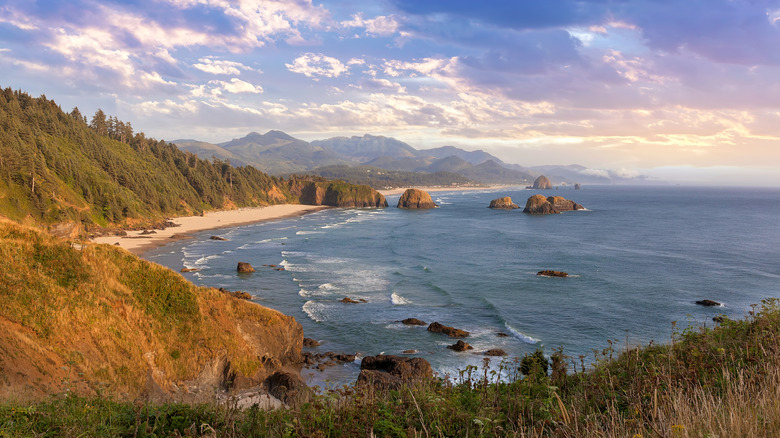
Located along a glorious seaside stretch of northern Oregon, Ecola State Park is a true gem. It spans 9 miles of coastline between the communities of Seaside and Cannon Beach and encompasses miles of trails, including an 8-mile leg of the Oregon Coast Trail (OCT). The OCT is organized into 10 sections, which can be hiked one at a time or all at once — it extends 425 miles all the way throug. There are also ample opportunities for even shorter stints.
Crescent Beach, a hallmark of Ecola State Park, is a jewel with Ecola Point on its northern edge and Chapman Point in the south. Its shape, which is just as its name suggests, means that no matter which direction you look, the scenery feels as though it hugs the surf. You can reach this sandy expanse on a 1.2-mile hike from a parking area at Ecola Point, which also serves as the trailhead for the Indian Beach Trail. An equally pleasant walk, Indian Beach Trail heads to the Indian Beach day use area, which can also be reached by car. Crescent Beach is only accessible on foot, making the latter particularly enjoyable and a bit more secluded.
Crescent Beach Trail is a moderately challenging hike that offers stunning views over the ocean, including a number of rugged sea stacks and lush coastal woods. It's best enjoyed during the summer, as it can get muddy in the winter, and you'll want to keep an eye out for exposed tree roots as you stroll. If you're on Crescent Beach Trail as part of a longer OCT trek, you'll continue south along Ecola State Park Road toward Cannon Beach, the renowned beach city that boasts beautiful, otherworldly views. Dogs are allowed as long as they're on leash, and be sure to bring your camera if you plan to stay for sunset.
Short Sand Beach Trail, Oswald West State Park
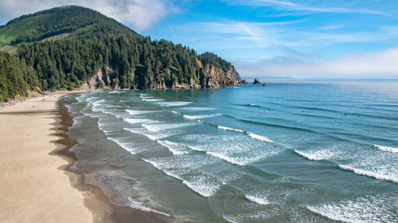
Oswald West State Park is just a 15-minute dip south from Ecola State Park on the iconic U.S. Highway 101, also known as the Pacific Coast Highway, where you'll find countless beautiful stops on your road trip. It's among Oregon's busiest state parks, seeing well over 1 million visitors each year. Oswald West spans nearly 2,500 acres and 4 miles of coastline. There's no camping available, but it's open year-round for use during the day. One of its most alluring attractions for visitors of all ages is what locals endearingly call "Shorty's," or Short Sand Beach, with a trail that takes you right to it.
The Short Sand Beach Trail is a quick, easy path that's perfect for the whole family. It's only about a mile out and back, but it packs a punch with views along the way that are especially impressive at low tide, as well as ferns, atmospheric trees swathed in moss, and a bridge over a babbling stream. Obviously, much of the fun to be had here is exploring the beach itself, which is perfect if you've got kids along, fancy a relaxing stroll on the sand, or love birdwatching. But if you're angling for a challenging day hike, start at Short Sand Beach and head south toward Neahkahnie Mountain, ascending over 1,700 feet for amazing views along the Devil's Cauldron, which covers about 8.6 miles in total.
Cape Falcon Trail, Oswald West State Park
You can pretty much bet that, in Oregon, anything with the word "cape" in it is bound to provide spectacular views. Also located in Oswald West State Park, Cape Falcon is certainly no exception. Just off the coast is the Cape Falcon Marine Reserve, which preserves the habitats of crabs, rockfish, and intertidal creatures like anemones. A hike along the Cape Falcon Trail, which extends 4.5 miles roundtrip, offers views over the reserve, which are especially remarkable at sunset — as are views of the Pacific Ocean just about anywhere along the way. The trail is essentially an oblong lasso shape, also called a "lollipop loop," or a singular trail that forms a loop at one end.
Oregon's rainy season typically spans from October and April, and midsummer can be very foggy. That means trails can sometimes get quite muddy when wet, but if you're willing to brave it, sometimes the mist makes for extra dramatic scenery. Walk through lush forest, watch the surf crash against the rocky cape, and even detour to Short Sand Beach on a short connecting path. The trail is rated moderately challenging for its elevation gain — around 567 feet in total — but the incline is gradual, so it doesn't feel like a big climb.
Netarts Spit, Cape Lookout State Park
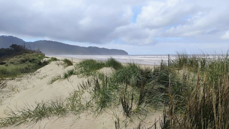
Just because you're hiking along the coast doesn't mean the scenery is limited to just the ocean. Netarts Spit, located in Cape Lookout State Park, is an approximately 5-mile windswept, grassy, and sandy landform that stretches between Netarts Bay and the open ocean. If you walk the entire thing, starting at the Cape Lookout Day Use Trailhead all the way to the mouth of Netarts Bay and back, you'll cover a little over 11 miles.
The name Netarts can summon a giggle for its cuteness, but it is actually derived from a word in the language of the local Tillamook tribe — after whom the nearby city is named — meaning "near the water." As far back as the 15th century, Netarts Spit was a place where Indigenous people made their home, as its unique geography allowed them to advantage of both the ocean and the protection of the bay. If you're lucky, you may be able to find a fully intact sand dollar, which tend to wash up on the shore. Just remember to pack an extra layer as the spit is pretty exposed to the elements, aside from a few stands of spruce and other trees, and wind or rain can be a factor.
Netarts Spit Trail is a great route to take in views of the surrounding landscape, as it's mostly open and free of major tree cover. Maxwell Point sits to the north near Three Arch Rocks Wildlife Refuge, a 15-acre wilderness area of large sea rocks that are home to Oregon's largest breeding colony of tufted puffins. You may also see other seabirds like pigeon guillemots, cormorants, and storm petrels.
Cape Lookout Trail, Cape Lookout State Park
Just south of Netarts Spit sits the eponymous focus of Cape Lookout State Park, where you'll find expansive views along the coast that, on a clear day, allow you to see Cape Foulweather to the south and Tillamook Head to the north. The OCT also passes through here, skirting around Netarts Bay and connecting to Cape Lookout Trail before continuing south.
Cape Lookout Trail is a worthy detour on the OCT or a trek unto itself, covering 5 miles roundtrip across terrain that makes it moderately challenging. You'll gain about 930 feet in elevation along the way, and you'll want to watch your footing toward the end, where there are steep cliffs that can become treacherous in stormy or windy weather.
Cape Lookout is a popular spot, so it can get busy at times, especially when the weather is nice. Crowds can make this trail more dangerous, especially in the steeper sections. But it's also this elevated and exposed point that makes it a superb place to watch gray whales as they migrate south to warmer waters between December and January, or north with their calves between March and April.
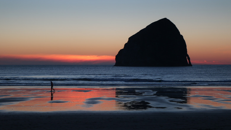
Cape Kiwanda Dune Hike, Cape Kiwanda State Natural Area
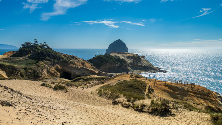
Just north of Pacific City, Oregon's underrated coastal gem with a panoramic beach, a beautiful stretch of rocky coastline embraced by dunes makes for a leisurely wander or short hike, depending on your style. Cape Kiwanda State Natural Area is instantly recognizable for its view of Haystack Rock, which looks like a slightly more stout version of its more famous cousin of the same name in Cannon Beach. The rocky cape is also sandy, with patches of grass and a few trees opening up to vast views of the ocean and coastline in both directions. It's home to a popular beach and marked paths with railings for exploring the sandstone bluffs and dunes.
Cape Kiwanda Trailhead is the most popular access point for the 2.2-mile lollipop loop trail to take in the view. However, it can get very busy and the parking lot is located right across from Pelican Brewing, a restaurant and bar overlooking Pacific City Beach. If you head to the Pacific Avenue Trailhead farther south, you'll add a mile each way to your trek, but you can avoid the vehicle congestion at the beach.
The Thumb via The Knoll, Siuslaw National Forest
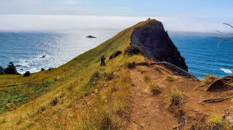
Just north of Lincoln City, a beautiful hike boasting spectacular views leads you toward The Thumb — also sometimes referred to as God's Thumb — a basalt outcrop that strikes a dramatic silhouette against the horizon. The trail can be accessed via an open space known as The Knoll, a grassy meadow that is itself home to a challenging and steep hike. Head to NE Devils Lake Boulevard to access the trailhead, which leads up to preserved natural space with incredible views all around.
The area is dotted with residential neighborhoods, so it's important to stick to the trails here to avoid stepping onto private property. Overall, you'll cover nearly 5 miles roundtrip and gain 1,180 feet in elevation. After over a mile on The Knoll trail, you'll arrive at Siuslaw National Forest and head to The Thumb Overlook. Due to erosion and wear from past visitors on The Thumb itself, AllTrails recommends turning around at the overlook to avoid further impact. Given that the trail is not maintained or officially designated, hiking to the crest of The Thumb can be hazardous. Hikers are better off enjoying the view from a safe distance.
Cook's Ridge Trail and Gwynn Creek Loop, Cape Perpetua Scenic Area
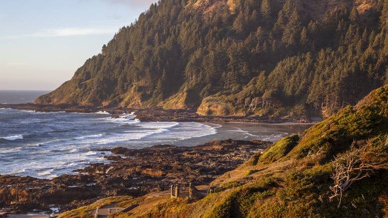
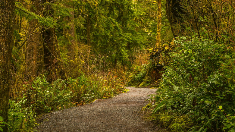
A gorgeously rugged area, the combined Cook's Ridge Trail and Gwynn Creek Loop takes hikers through an old-growth forest that feels otherworldly, especially on a misty day. At 6 miles long, with elevation gain of about 1,250 feet, it's both moderately challenging and exceedingly rewarding for its diverse scenery. Nestled in Cape Perpetua Scenic Area, you'll find interpretive signage along the way, pass through stands of spruce, and wander around the pleasant Gwynn Creek, where you can scout for local wildflowers and relax amid the ferns.
Cape Perpetua can be busy, so this route is a great way to escape weekend crowds, especially in the summertime. It heads inland from the Cape Perpetua Visitor Center, passing by another path called the Discovery Loop Trail, which features even more Pacific Northwest scenery. You'll encounter a number of switchbacks as you head along Cook's Ridge, followed by stunning photo ops at Neptune State Scenic Viewpoint and Cape Perpetua Marine Garden. The final section of the trail joins up with the OCT.
Hobbit Beach to Heceta Head, Heceta Head Lighthouse State Scenic Viewpoint
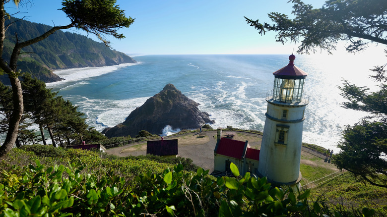
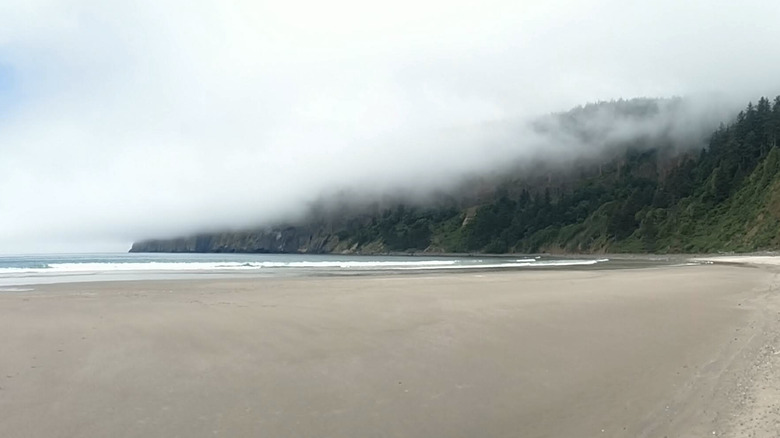
Heceta Head is known for its historic lighthouse, first illuminated in 1894. It's only a 20-minute drive south of Yachats, an overlooked coastal haven perfect for a quiet escape. And Heceta Head's natural surroundings are just as impressive, with rugged cliffs and windswept trees that frame expansive views of the ocean. On the sylvan route to the beacon from Hobbit Beach, which sits just north of Heceta Head Lighthouse, hikers get amazing views of the landmark with the option for either an out-and-back or lollipop loop hike.
From start to finish, this hike is roughly 8 miles in total, or you can shorten it to around 6.6 miles roundtrip on a straighter path down to sandy Hobbit Beach. Hikers can begin or end at either the Washburne State Park Trailhead or Heceta Head Lighthouse, where the trail follows a scenic ridge through the trees and then descends towards the oceanside landmark.
Oregon Dunes Loop, Oregon Dunes National Recreation Area
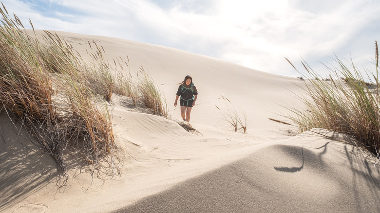
Oregon Dunes National Recreation Area is a busy hub for all kinds of outdoor activities, including paddling, birdwatching, ATV adventures and, especially, hiking. The Oregon Dunes Loop trail covers around 4.8 miles, and it offers an exceptional glimpse of this unique, biodiverse landscape. Situated well away from the noise of the dune buggies, you'll find yourself in a serene part of the park with access to a tranquil beach and, of course, plenty of dunes.
Starting at the Oregon Dunes Trailhead, you'll get a stunning view right away from a wooden viewing platform, after which you'll descend onto the sand and through picturesque copses of trees. If it's been rainy, some areas can become quite wet or even flooded, so you may need to navigate around pools. The beach is also easiest to walk along during low tide, but be aware of snowy plover nesting season from mid-March to mid-September, when areas are closed off to protect their fragile habitat. It's important to note that while dogs are welcome at other times of the year year, Fido isn't allowed on the trail or beach during plover nesting season as an additional safeguard, given that the birds are a threatened species.
Sunset Bay to Cape Arago, Sunset Bay State Park
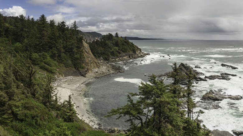
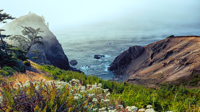
About 12 miles west of Coos Bay, the largest bay on the Oregon coast with gorgeous views, Sunset Bay State Park encompasses some of the most beautiful parts of Oregon's impressive coastline. Rugged, rocky bluffs and sea stacks meet gorgeous ocean views along numerous hiking trails, some of which connect to the nearby Cape Arago State Park about 2 miles down the coast. Between the two sits Shore Acres State Park, making this a phenomenal triad of preserved wilderness areas.
For a great day hike, visit all three of these parks on a route that is around 8 miles roundtrip. This journey can be shortened on various other routes that take hikers along the coast as well as inland. Shore Acres and Cape Arago are spectacular places to peep seals, sea lions, and migrating whales, especially on Shell Island and from the Simpson Reef Overlook. However, visitors should keep in mind that the north trail at Shell Island is closed from early March to late June for the safety of the seal pups.
As the path heads through Shore Acres, which was historically the estate of a timber magnate named Louis J. Simpson, you'll be able to enjoy beautifully maintained formal gardens with flora from around the globe. The gardens are the only part of the trail from Sunset Bay to Cape Arago where dogs aren't permitted.
Natural Bridges Cove, Samuel H. Boardman Scenic Corridor
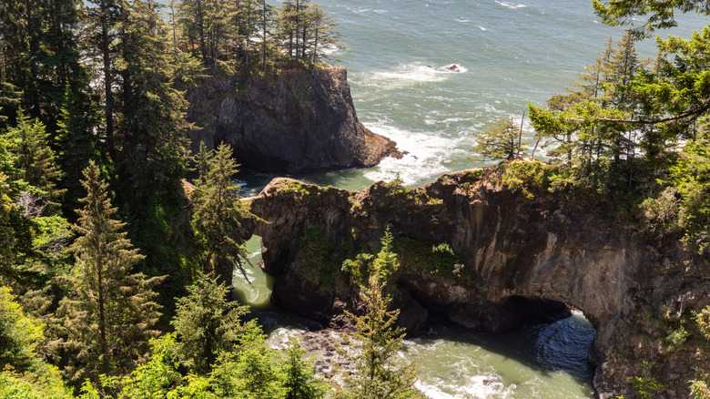
The Natural Bridge area is one of many worthy stops within the gorgeous Samuel H. Boardman State Scenic Corridor, which stretches for 12 miles along Highway 101. The corridor includes miles of trails, including an 18-mile stretch of the OCT. A short and sweet journey, the walk to Natural Bridges Cove is roughly half a mile to a viewpoint over Seal Cove. The route packs a punch with great views of the rock arches and "blowholes" that capture dramatic scenes of crashing waves. Topped with trees and cascading into the water, these formations are innately postcard-worthy, so don't forget to take a snapshot or two.
Methodology
Our research for this guide began by reviewing a number of blog articles written by experienced hikers and travelers in the Oregon coastal area, including IHeartPacificNorthwest.com, NoahLangPhotography.com and organizations like OregonHikers.org and HikeOregon.net. In addition to the author's personal experience hiking in some of these areas, more detailed information about the trails and their surroundings came from sites like TravelOregon.com, StateParks.Oregon.gov, OregonMarineReserves.com, PDXMonthly.com, AllTrails, and Komoot. We also sourced some additional data and historical context from Britannica.com and Wilderness.net.