13 Impressive World Records Held By Stunning US National Parks
Extraordinary geological, climatic, and ecological forces have shaped U.S. national parks over millions of years into the beautiful landscapes they preserve for visitors today. As a result, many of them hold incredible world records that reflect the diversity of nature's extremes. From scorching temperatures and massive rock formations, to rare landforms found nowhere else on Earth, these records offer a different way of understanding what makes U.S. national parks worth visiting.
This article highlights a selection of impressive world records held by national parks, focusing on features that visitors can see and explore for themselves. Each record reveals something fundamental about how the planet works — why some deserts become so hot, how caves form underground, and how stunning shapes emerge from seemingly solid rock. These parks are not only iconic travel destinations, but living archives of Earth's most powerful natural forces.
Hottest air temperature: Death Valley National Park
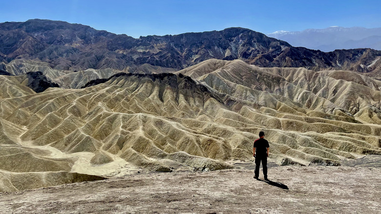
California's Death Valley National Park is famous for its otherworldly salt flats, sand dunes, and colorful canyons. While you may recognize these highly photographed desert landscapes, you may not know that Death Valley National Park holds the world record for the hottest air temperature ever recorded on Earth. Way back on July 10, 1913, the temperature in Death Valley was recorded at a scorching 134 degrees Fahrenheit. This place is also extremely dry. On average, the park gets 1.94 inches of precipitation per year.
Death Valley National Park is home to the lowest point below sea level in North America, surrounded by extremely high peaks of ancient mountains. Due to the area's low latitude of around 36 degrees north, the sun's intensity is quite strong in the summer. Rays of blazing sunlight penetrate down to the stones and soil, which then radiate heat back into the air. The National Park Service says that the best time to visit is between November and March. "Even during spring and autumn the heat can be unbearable for most people," it warns.
Temperatures at the park are often more bearable in the early morning or evening. Plus, the sunrise and sunset views in Death Valley National Park are worth making a special trip for. The park also holds a Gold Tier designation from the International Dark-Sky Association, making it one of the best places in the country to view the constellations.
World's longest cave system: Mammoth Cave National Park
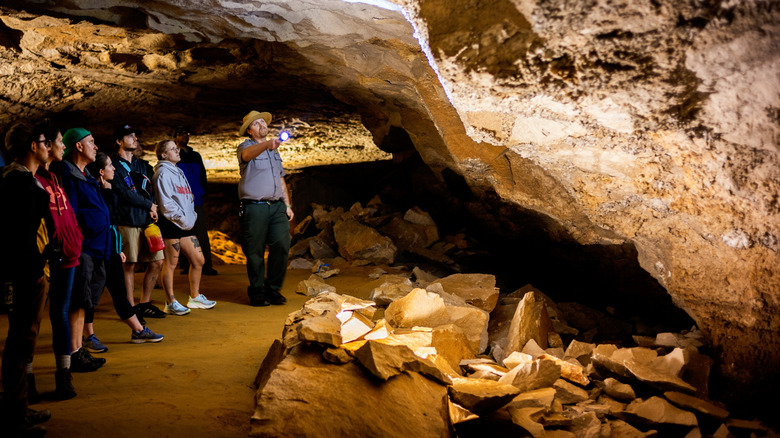
The aptly-named Mammoth Cave National Park, located in south-central Kentucky, contains a network of more than 400 miles of underground caves and caverns. It holds the world record for being the longest known cave system in the world, though not the deepest. Successively over the park's long history, people have crawled into its depths to discover an ever-expanding number of caves and connections. In 1924, the public was introduced to the "Frozen Niagara," a spectacular underground wonder located within the park.
Mammoth Cave is classified as a solution cave, formed from acidic water carving holes and passages into limestone over time. Limestone is a water-soluble rock found in abundance in this region. It's believed that a vast but shallow sea covered this area millions of years ago. That's why these caves contain troves of artifacts. For example, paleontologists have found fossils of no less than 40 different shark species from hundreds of millions of years ago, as well as artifacts from ancient humans who inhabited or explored the caves as far back as 12,000 years ago.
The park offers various guided cave tours, ranging from a half-hour to over three hours. Different cave features and themes are covered, including stalactites, stalagmites, unusual rock formations, huge cavernous rooms, and even a sinkhole. Above ground, visitors can enjoy 53,000 acres of rolling hills, forests, and rivers, complete with hiking trails, canoe and kayak rentals, horseback riding trails, and more.
World's largest tree by volume: Sequoia National Park
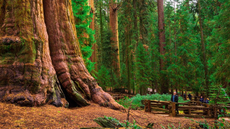
Sequoia National Park — America's second-oldest national park and a California gem — is where you'll find The General Sherman Tree, the largest tree on Earth by volume and a living monument that feels almost unfathomable on first encounter. The trunk alone weighs nearly 2.8 million pounds. Containing enough wood to build more than 120 average-sized houses, this giant sequoia stands in the Giant Forest of Sequoia National Park and has become one of the park's most visited and photographed landmarks.
Reaching General Sherman is surprisingly easy. A paved, well-maintained trail leads from the parking area through a grove of towering sequoias. Walking the short loop around the tree helps put its volume into perspective, especially when compared with nearby sequoias that would themselves be considered enormous anywhere else in the world. In addition to the tree's record-breaking volume, it is also impressively tall, rising 275 feet from its base.
Visiting General Sherman can be part of a longer day exploring the Giant Forest, with nearby trails leading to additional sequoia groves and scenic overlooks. While the trees are certainly the main draw, rock climbing and camping are also popular activities at the park.
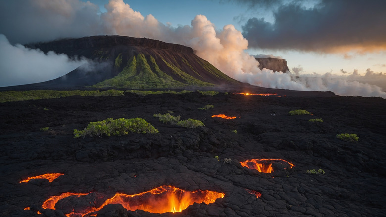
World's most active volcano: Hawaii Volcanoes National Park
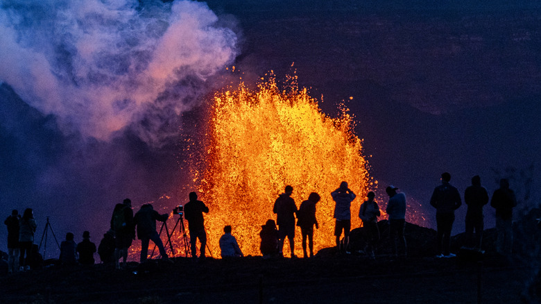
The Hawaiian shield volcanoes are the world's biggest mountains. Kīlauea is the youngest, and the most active — not just in the region, but on Earth. Located in Hawaii Volcanoes National Park, at least 75 eruptions have occurred at Kīlauea in the last 12,000 years, according to the Smithsonian Institution's Global Volcanism Program. The duration of a volcano's eruptions is an important factor in measuring its activity. From 1983 to 2018, Kīlauea was erupting nearly continuously. In May of 2018, there was a cataclysmic eruption. After this, the volcano entered a two-year pause before beginning another period of continuous eruption in 2020.
Visitors to the park may be able to catch a glimpse of lava actively flowing into the ocean, or lava and ash spewing up from the Halema'uma'u crater. Some volcanic activity is visible from the Visitor's Center, and at the many stops along Crater Rim Drive. There are also many gorgeous hiking trails that traverse the 350,000-acre park. Hike across fields of cooled and dried lava beds, through lush rainforests, and amid colorful deposits left by volcanic gases in the soil. The park also has a one-of-a-kind camping experience in a wild eucalyptus forest.
World's first international peace park: Glacier National Park
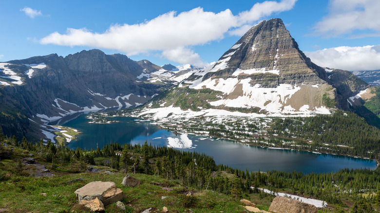
During the interwar period, Rotary Clubs in the U.S. and Canada led an initiative in the remote northern Rocky Mountains to create a symbol of hope and peace among nations. The mountain range that starts in northern New Mexico curves in an arch all the way through northwestern Montana and into western Canada. The Rockies spanned both Waterton Lakes National Park in Alberta and Glacier National Park in Montana, known as the Crown of the Continent for its unmatched beauty. In 1931, the two parks were united to become Waterton-Glacier International Peace Park, where U.S. and Canadian governments agreed to jointly manage the park as a way to foster peace and goodwill. This dual national park is the first of its kind in the world and a UNESCO World Heritage Site.
Today, the park offers 700 miles of trails for various outdoor activities such as hiking, backcountry camping, fishing, rafting, horseback riding, and more. The park also offers super cozy on-site lodging and dining options. For more than 40 years, the park has sustained a connection to the Blackfeet Nation and Confederated Salish and Kootenai Tribes, as the land is part of their ancestral territory.
Highest density of natural stone arches: Arches National Park
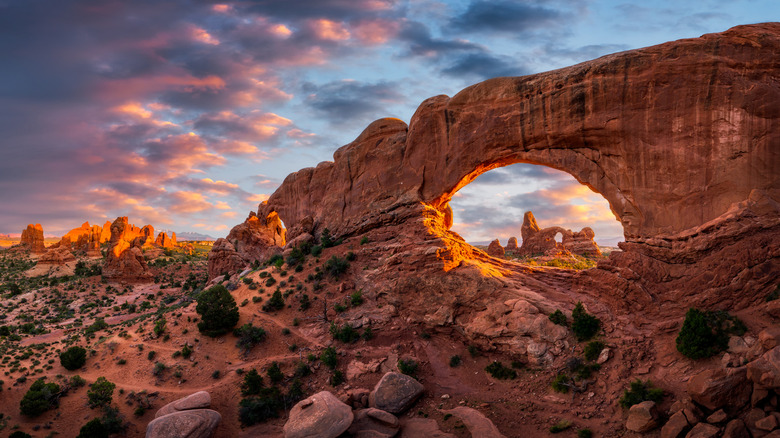
With more than 2,000 formations that have developed over thousands of years, Arches National Park in Utah contains the greatest concentration of natural stone arches on Earth. These arches form as erosion gradually wears away weaker rock layers, leaving behind delicate, freestanding spans of sandstone. The park's geological diversity is complemented by its striking colors and textures. Red and orange sandstone contrasts with clear blue skies, making it an incredible destination for nature photography.
Among the many arches, some are more well known than others. For example, Landscape Arch stretches over 300 feet, making it the longest in North America. Other arches rise as high as 112 feet, creating dramatic vertical features across the park's high desert terrain.
Visitors can explore the park's network of trails and scenic drives. Short, accessible walks lead to well-known arches such as Double Arch Viewpoint and Trail and the Broken Arch Trail, a hidden gem trail to a stunning view. Longer hikes such as the Tower Arch Trail are more challenging, with steep inclines, deep valleys, and dunes that can present quite strenuous terrain to traverse.
Largest concentration of boxwork caves: Wind Cave National Park

Wind Cave National Park in South Dakota is home to the world's largest concentration of boxwork cave formations, containing roughly 95% of all such formations on Earth. Boxwork is a rare geological structure composed of thin blades of calcite that protrude from cave walls and ceilings, forming intricate, honeycomb-like patterns. Over thousands of years, these delicate formations have resisted erosion while surrounding rock gradually dissolved, leaving behind a striking lattice of calcite spikes.
The park's cave system is also one of the longest in the world, with over 130 miles of mapped passages. There are ample opportunities to view these unique formations up close. Visitors can only explore the caves by booking one of several differently themed guided tours, as self-guided tours of the caves are not permitted.
The shortest and gentlest tour is one hour long, but visitors should still be cautious of slippery stairs, dim lighting, and low ceilings. More challenging routes take visitors through narrow passageways for up to four hours, and offer an introduction to caving. Each tour provides a close look at the intricate calcite structures while explaining the geological processes that created them. Above ground, the park encompasses rolling grasslands and forested areas, offering additional trails and wildlife viewing opportunities with an impressive population of bison and prairie dogs.
World's largest concentration of geysers: Yellowstone National Park
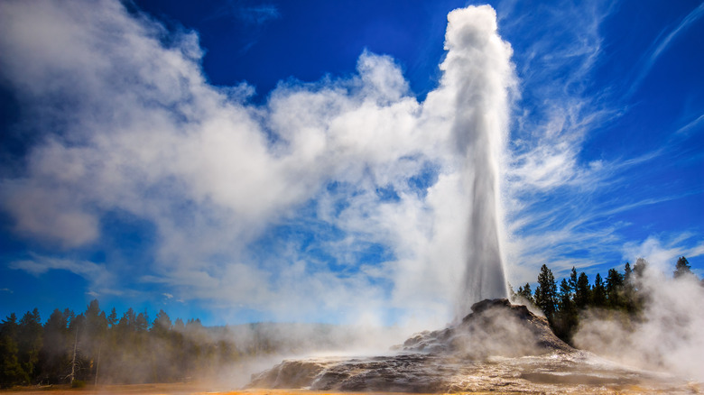
More than two-thirds of the world's geysers are located in Yellowstone National Park. It's the world's first national park located primarily in Wyoming, as well as parts of Montana and Idaho. The park has more than 10,000 active geothermal features total, and around 300 geysers, making it the largest concentration on Earth. Yellowstone is a UNESCO World Heritage Site, preserving tremendous ecological diversity within its vast forests, rivers, and wildlife alongside the geysers.
Geysers are hot springs that periodically erupt, shooting water and steam into the air due to underground heat, pressure, and water flow. The park's location atop a massive volcanic hotspot provides the heat necessary to fuel these dramatic natural fountains, creating one of the most geothermally active landscapes in the world.
Throughout the park, you'll encounter steaming fumaroles, colorful hot springs, and bubbling mud pots. Old Faithful, the most well-known geyser, erupts on a regular schedule of roughly every 102 minutes, while others erupt more sporadically. Visitors can explore the main geysers and hot spring sites within the park along a network of boardwalks and trails that safely wind through the steamy basin.
World's largest gypsum dunefields: White Sands National Park
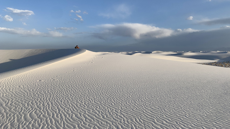
Step into a world of glistening white dunes made not of regular sand, but of gypsum. It's an otherworldly landscape, and contains the largest gypsum dunefield in the world. "The endless waves of pure white gypsum sand look stunning in every direction and feel like stepping into a dream," reads one Google review.
Gypsum is a common mineral used as a binding agent in many everyday products, from drywall to toothpaste. It is industrially mined in many parts of the world, and the U.S. consumes about 30 million tons of it each year. However, at White Sands National Park in southern New Mexico, it is protected for visitors to enjoy in its natural state, where it has been since an ancient seabed deposited the minerals millions of years ago.
Dune sledding a common activity, especially at The Roadrunner Picnic area that offers shaded platforms. You can bring your own or purchase one at the trading post. The sun and heat can be intense, given the park's location in the Chihuahuan Desert. The park offers five different hiking trails, but hikers are cautioned against going out if temperatures reach 85 degrees Fahrenheit or above. Bring plenty of water, since it is very limited on site.
World's largest collection of hoodoos: Bryce Canyon National Park
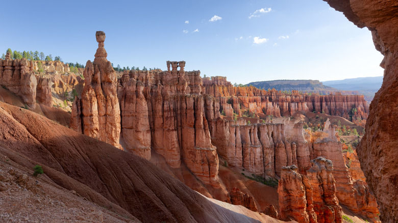
Described as "America's most unique national park," Bryce Canyon National Park in Utah contains the world's largest concentration of hoodoos — tall, irregular spires of rock formed through the long process of erosion. These formations are as spectacular as they are strange to witness in person. They emerge as water freezes and thaws in cracks within the rock, gradually breaking it apart and leaving behind narrow columns. Over time, this process has produced vast natural amphitheaters densely packed with thousands of hoodoos, creating one of the most distinctive landscapes in the U.S.
The park is organized around a series of overlooks and trail networks that make these formations highly accessible. Several scenic hikes and drives connect multiple viewpoints along the rim, offering elevated perspectives across the hoodoo-filled basins below. From these points, visitors can see how variations in rock hardness, slope, and exposure shape hoodoos into dramatically different sizes and forms within the area.
Below the rim, pathways like the Tropic Trail allow visitors to hike among the formations themselves. Weave between tightly clustered spires, and get a close-range view of their textures, colors, and scale. Routes vary in length and difficulty, making it possible to tackle both short walks and longer hikes.
Largest exposed granite formation: Yosemite National Park
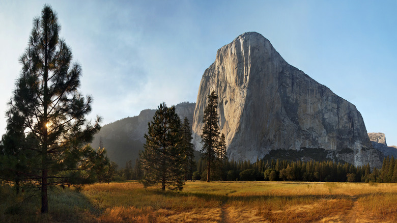
Located in California's Yosemite National Park, El Capitan dominates the Yosemite Valley with a sheer granite face that rises more than 3,000 feet from the valley floor. As the world's largest exposed granite formation, it is both a geological monument and one of the most recognizable landmarks in the U.S. national parks system. Even visitors with no interest in rock climbing flock to this site to crane their necks upward to take in its record-breaking scale.
One memorable way to experience El Capitan is simply by seeing it up close. From El Capitan Meadow, the monolith reflects changing light throughout the day. On warm days and evenings, it's common to spot climbers inching their way up the rock face, appearing impossibly small against the vast wall of granite.
El Capitan is at the center of Yosemite's world-renowned climbing culture. Even if you never leave the ground, chatting with climbers at the base or watching them haul gear up the wall offers a glimpse into one of the park's most enduring traditions. Adventurous visitors can stop by the Tunnel View, as well as various points along the Big Oak Flat Road, for phenomenal views over the park and the mountain.
Largest concentration of brown bears: Katmai National Park and Preserve

At Katmai National Park and Preserve in Alaska, there is a population of about 2,200 bears across 4 million acres, the most dense population of brown bears anywhere in the world. Between June and September, brown bears migrate inland from the coast, following the upriver salmon migration, one of their main food sources that help them bulk up before winter hibernation.
There are four popular viewing platforms in the park for visitors at this remote location, which is accessible only by air and sea. These are located at Brooks Camp, with views of brown bears hunting for salmon in Brooks River. One visitor who arrived at the park in the second week of September for the so-called "Fat Bear Week," wrote in Google review, "There were bears everywhere fishing for end of the season salmon, mothers and cubs, big males, dark brown, light brown and every color bear in between."
The Valley of Ten Thousand Smokes Road offers breathtaking views of the park's volcanic region, the site of the largest volcanic eruption of the 20th century. The park has less than 5 miles of maintained hiking trails, so backcountry hiking is the way to go. Of course, explorers should be well equipped to enter bear country.
Largest plug dome volcano in the world: Lassen Volcanic National Park
Lassen Peak is the world's largest plug dome volcano, rising 10,457 feet above sea level in northern California. Unlike volcanoes known for flowing lava, plug dome volcanoes are defined by thick, sticky magma that barely moves. Instead of spilling outward, the lava slowly pushes upward, piling on itself and solidifying near the surface to form a steep, rounded dome. The result is a volcano that appears solid and immovable from the outside, yet volatile on the inside.
Lassen Volcanic National Park is compact and easy to explore. A scenic highway connects hydrothermal areas, alpine lakes, and volcanic landscapes shaped by eruptions as recently as the early 20th century. Steam vents, bubbling mud pots, and sulfur-scented fumaroles at places like Bumpass Hell offer constant reminders that the volcano is dormant, not extinct. For those seeking a more intense experience, the hike to the summit of Lassen Peak may be a rewarding adventure. The trail climbs steadily across hardened lava and pumice fields before reaching panoramic views that stretch across forests, lakes, and neighboring volcanic peaks. On clear days, towering Mount Shasta is visible in the distance.
Methodology

This guide was created with the help of world record lists and the National Park Service (NPS) registry of World Heritage Sites. World record details were gathered and verified using official NPS resources. Additional background information about each park and its features was taken from the U.S. Geological Survey and the Smithsonian Institute's Global Volcanism Program, as well as renowned publications such as National Geographic, travel blogs such as Parks & Points, and tourism boards such as Travel South Dakota. Also part of our research was visitor feedback shared on Google Reviews and Tripadvisor.