The Best Scenic Byways For A Breathtaking Road Trip Through The Ozarks
Across more than 50,000 square miles of rolling, woodsy landscapes in Missouri, Arkansas, Oklahoma, Illinois, and Kansas the Ozarks comprise a beautiful and ecologically diverse region. Highland forests turn brilliant shades of red and yellow in autumn, making it a hot spot for Midwesterners craving a fall vacation, per Samantha Brown. And along with hills and gorgeous bluffs come great views, state parks, charming towns, and plenty of great places to stay.
Scenic byways are a perennial favorite when it comes to exploring the Ozarks, and fortunately, there are many to choose from! From state-wide routes that can be split into multiple days to short stints you can easily accomplish in an afternoon, Ozark roads can lead you to historic landmarks, hidden gems, and photo-worthy overlooks. Depending on the route and how you like to travel, many of the byways make ideal motorcycle touring routes, and in a few cases, it's easy to combine different routes or tack on additional loops to make the most of the scenery. You'll find a wide range of accommodation options along the way, whether you aim for solitude at rustic campsites or all the bells and whistles of fully equipped cabins.
Byways are also perfect for augmenting a romantic weekend away or making the drive to the campground with the family more interesting. And if non-motorized transportation is more your speed, bicycle routes are plentiful in the region, too. Whether you're heading to an Arkansas Razorbacks game in Fayetteville, Arkansas, or you'll be passing through Missouri on the "Mother Road," America's most iconic highway that's a must-do trip in 2026, here are 11 distinctive drives worth a spin in the Ozarks.
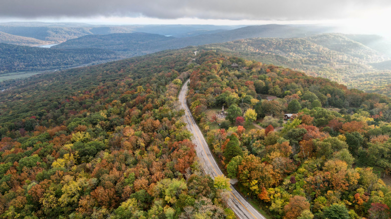
Boston Mountains Scenic Loop, Arkansas
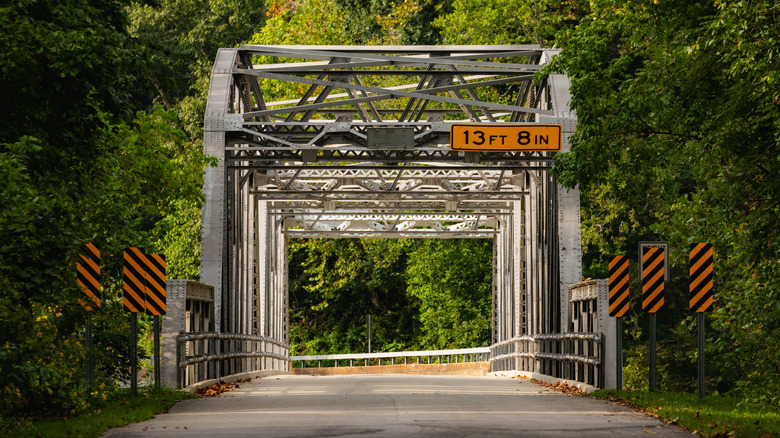
Arkansas easily lives up to its nickname as The Natural State with scenic driving circuits like the Boston Mountains Scenic Loop. Combining Interstate 49 and U.S. Highway 71, the route emphasizes two north-south legs that run roughly parallel to one another and make short connections at either end, stretching for a total of about 80 miles round-trip. Both highways are independently designated as scenic byways, so even if you only travel one way, you can't go wrong with either. And as far as scenic byways go, being on an Interstate highway means you can also make good time between the cities of Alma and Fayetteville while also taking in views of Kessler Mountain outside of the latter, plus expansive vistas of the countryside and other mountains in the Boston range. Bridges and the state's only highway tunnel are features of I-49, but if smaller, more historic roads are your thing, you won't want to miss its meandering complement to the east, U.S. 71.
Tracing a winding, old stagecoach route through the mountains, U.S. 71 offers a bit more of an up-close-and-personal experience with the terrain. This half of the Boston Mountains Scenic Loop may appeal to the daytrippers and the rubberneckers even more, as you can more easily pull off the road in various places to take in the view. Stop in Mountainburg, an outdoor-friendly Ozarks destination set amid rolling hills, where you should be sure to grab a burger at the funky roadside hotspot called Neon Moon, or head into Lake Fort Smith State Park for camping, boating, and hiking.
Pig Trail Scenic Byway, Arkansas
The Pig Trail Scenic Byway is one of Arkansas' most popular scenic routes through the Ozarks. It officially stretches from Clarksville up to Eureka Springs for more than 100 miles of scenic twists and turns. The route is named for the feral pigs that made their home in the woods when the road was built by the Civilian Conservation Corps back in the 1930s, but it's also known for its exciting hills, sometimes likened to the spiral shape we associate with a pig's tail. Stop at the classic Pig Trail Scenic Byway sign or Pig Trail Falls for a photo, then take in the view from scenic overlooks, stop for hikes in state parks like Withrow Springs State Park, or visit Turpentine Creek Wildlife Refuge to see tigers and other exotic animals that have been rescued from international trade. Stop by Huntsville for the farmer's market in the downtown square on Tuesdays from April to September, and enjoy comforting, "homestyle cookin'" at Granny's Kitchen.
It's easy to split the Pig Trail Scenic Byway into two parts, focusing on either the east-west stretch between Clarksville and the town of Ozark or the longer north-south route between Ozark and Eureka Springs. Overall, it encompasses U.S. Highway 64 and Arkansas Highway 23, and whether you're on two or four wheels, this is a spectacular cruise for leaf-peeping in the fall. This is largely because the trees are pretty close to the road along the way, making for an atmospheric drive. During football season, you'll also likely encounter Arkansas Razorback fans on their way along this time-honored commute to see the University of Arkansas game in Fayetteville.
Ozark Highlands Scenic Byway, Arkansas
Starting in Clarksville, the Ozark Highlands Scenic Byway heads north along Arkansas Highway 21 through the Boston Mountains. The meandering two-lane highway is tree-lined much of the way, perfect for seeing fall foliage. There are also picturesque overlooks and plenty of hikes, such as short routes to a number of waterfalls like Paradise Falls, which are especially rewarding shortly after there's been a good rain. The byway also bisects the Ozark Highland Trail, 164 miles of which wind through the Boston Mountains, making it one of Arkansas' most incredible summer hikes.
If you follow Arkansas Highway 21 up to the Missouri border, you'll cover just about 100 miles, but the most scenic area is an approximately 35-mile stretch through Ozark National Forest. Motorcyclists are a welcome crowd around these parts with the availability of specialty accommodations like So Live So Ride near the community of Ozone, which consists of a series of glamping cabins on its "moto ranch." The road's hilly and winding character is perfect for exploring either solo or with a group. Don't miss a little detour off the main route at Arkansas Highway 43 to Boxley Valley Historical District, a preserved cultural landscape around the Buffalo National River and its surrounding wilderness.
Route 66, Missouri
One of the most storied road trip routes in the world, Route 66 hangs a broad arc across two-thirds of the U.S., stretching from Chicago, Illinois, to Santa Monica, California. The so-called "Mother Road" delivers neon nostalgia and kitschy Americana across 2,238 miles — slightly shorter than its original length of 2,448 when it was completed in 1926. More than 300 miles of the route cross the state of Missouri, heading straight through the northern Ozarks. While not quite as dramatically mountainous as some areas farther south, there's still plenty of rolling, woodsy terrain to enjoy along this route, not to mention the history and roadside funkiness that characterizes Old Route 66. Much of the original route has been realigned to follow Interstate 44, but there are still some wonderful legs where you can take the original road through the countryside and local communities.
One of the more popular stops along this route is Meramec Caverns. The natural attraction formed over the course of 400 million years as water gradually whittled away the limestone to create broad passages, and mineral deposits created dramatic stalactites and stalagmites. Continue about an hour southwest on Historic Route 66, and you'll encounter Devil's Elbow Bridge, a century-old structure over the Big Piney River, which doubles as part of Bicycle Route 66, an adventure cycling route that parallels the iconic Mother Road. And a half-hour north of Lebanon, you'll encounter Ha Ha Tonka State Park, home to some unique turn-of-the-century ruins, which is itself something of a gateway to the expansive Lake of the Ozarks region.
Talimena National Scenic Byway, Arkansas and Oklahoma

A wonderful addition to your itinerary of picturesque drives in the far western Ozarks is the Talimena National Scenic Byway, which winds through an underrated mountain region where you'll find one of America's best fall foliage drives. Talimena features gorgeous views from more than 20 vistas along a loop. At 54 miles total, the itinerary connects Mena, Arkansas, and Talihina, Oklahoma — hence the name, which is a combination of the two cities. Most of the route in southeastern Oklahoma provides excellent views of the Ouachita National Forest, and Talimena State Park marks the entrance to the byway in Talihina, where you can find campsites and hiking trails.
Stretching 261 miles, the West-Northwest Scenic Byway is another nearby detour in far west Arkansas that also starts from Mena. A wiggly north-south segment along U.S. Highway 71 runs up to Interstate 540 outside of Fort Smith, near the Oklahoma border. Another segment swings eastward from there, sticking primarily to Arkansas Highway 10 until the town of Ola. This region brims with bucolic countryside views and historic small towns. In Fort Smith, check out a number of museums like the U.S. Marshals Museum, Fort Smith Regional Art Museum, and Fort Smith National Historic Site.
Scenic 7 Byway, Arkansas
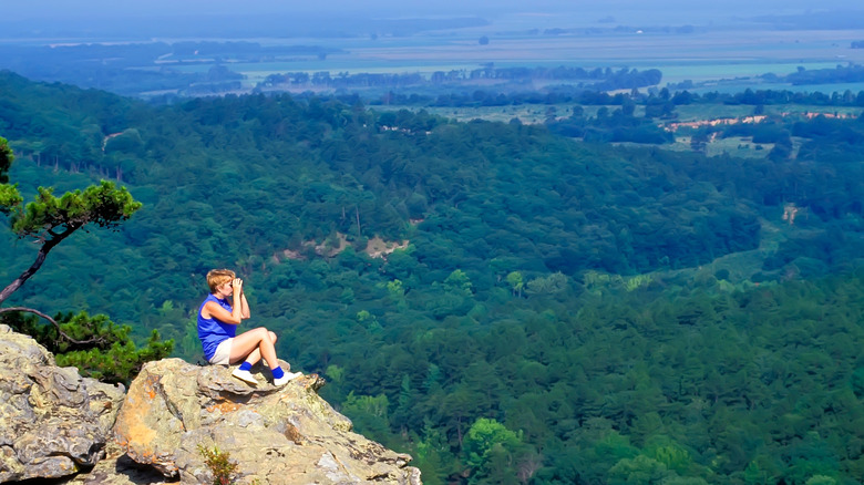
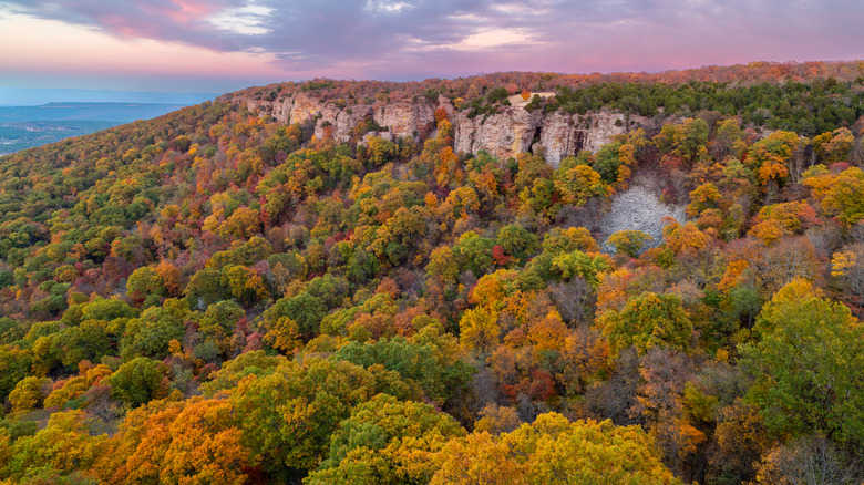
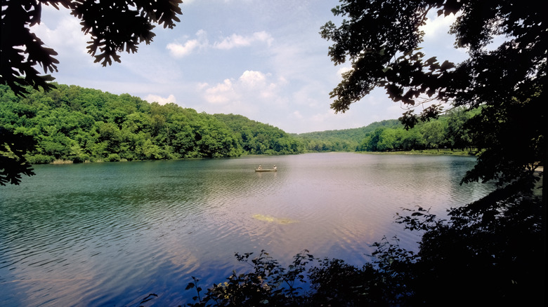
From the Missouri border in the north and the Louisiana border in the south, the Arkansas Scenic 7 Byway is a must-do drive that spans the entire length of The Natural State. It's perfect for multi-day trips at a total length of 290 miles, following Arkansas Highway 7 and covering a wide range of ecological and geological regions, from the Ozark Mountains in the north to pine forests and the West Gulf Coastal Plain in the south. Stop to fish or camp at Nimrod Reservoir and the Fourche LaFave River, hike a segment of the 192-mile Ouachita National Recreation Trail, or detour to Petit Jean State Park, which features sweeping views from the summit of its namesake mountain.
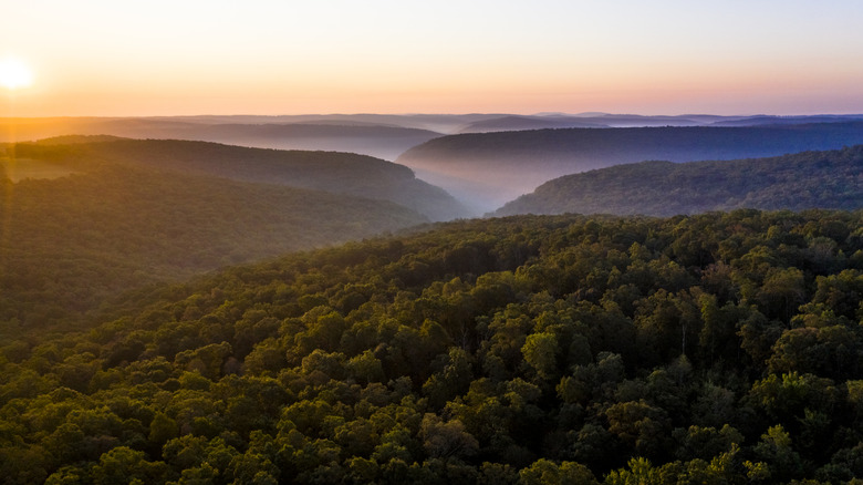
Along the Scenic 7 Byway, make sure to check out the Grand Canyon of Arkansas, a wildly underrated hiking destination full of spectacular views. An additional scenic loop around this area makes for a great detour from the town of Jasper via Arkansas Highway 7, south to U.S. Highway 64, then over to AR 21, which swings north again toward Ponca before you jog a little bit eastward back to Jasper. Don't miss a bite to eat at The Cliff House Inn & Restaurant, which offers spectacular views over the landscape from its dining room. Stay a while in one of five rooms or three cabins, the latter of which are located about a mile away. This region is a favorite with motorcyclists, with curving, hilly roads and the occasional hairpin turn. You may see elk roaming around the area near Ponca and the Buffalo National River, where the regal creatures were reintroduced in the 1980s. A little more than 100 were released into the wild, and the herds now number almost 500.
Mount Magazine Scenic Byway, Arkansas
Mount Magazine clocks in as Arkansas' highest point at 2,753 feet, and along with a state park offering fantastic accommodations, dining, and hikes, you can also tour around and over the mountain on a drive with postcard-worthy views. The 45-mile byway starts in the town of Havana on Arkansas Highway 309, and more than half of the route winds through Ozark National Forest. It takes you directly into Mount Magazine State Park, a mountain paradise for sweeping views and adventure.
Take in the views over the course of an hour or two from a number of overlooks or stay a while to take advantage of the rustic lodge, luxe cabins with fireplaces and hot tubs, or camping. From the park, you'll descend the mountain to the town of Paris, where you'll find a number of shops and can learn about the area's mining history at the Paris-Logan County Coal Miner's Memorial. Head north into the rolling countryside, and round out your trip with a stop at Aux Arc, a campground on the shores of Ozark Lake.
Ozark Mountain Highroad, Missouri
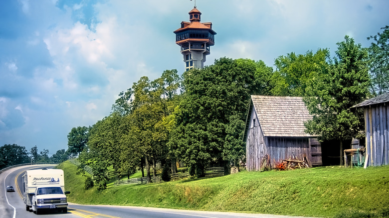
A short-but-sweet byway at only a little more than 7 miles long, the Ozark Mountain Highroad is located just a few miles northwest of Branson, Missouri. Starting at U.S. Highway 65 directly north of town, the route heads west via what was originally called Arkansas Highway 465 and is now mapped as a continuation of AR 76, where it intersects with AR 376. Along this postcard-worthy stretch, you'll climb in elevation for beautiful views over the region. It's popular with bicyclists who like to take in the woodsy view, too. Toward the junction of AR 376, you'll find the Shepherd of the Hills' Inspiration Tower, a landmark of the landscape providing the opportunity to see over the valley from 230 feet high or ride a zipline over it. And less than 2 miles to the west from there, grab a bite at Billy Gail's, a local gem for breakfast and lunch that's known for its giant pancakes.
Branson is a surprising leaf-peeping resort city that's the perfect place to see fall colors. You'll find plenty of beautiful vistas on driving detours around this unique town, especially around the meandering Table Rock Lake. Stop for a photo-op at Chapel of the Ozarks at Top of the Rock, just south of Branson, which boasts even more beautiful views over the water and forested valley.
Sylamore Scenic Byway, Arkansas
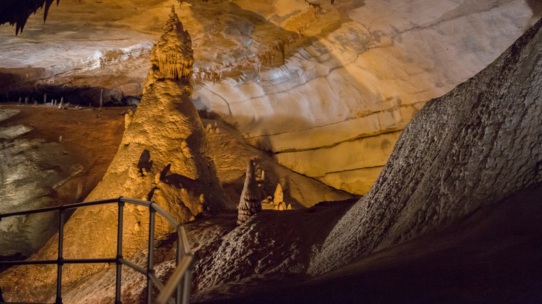
Located to the east of most of the other byways on this list, the 26.5-mile Sylamore Scenic Byway winds through Ozark National Forest. It combines Arkansas Highways 5 and 14 along with Forest Service Road 1110 in a fishhook-shaped route between the community of Calico Rock at its northernmost point and the popular Blanchard Springs Recreation Area at its southern terminus. This under-the-radar recreation area boasts crystal-clear waters and wooded hills and is home to the spectacular Blanchard Springs Caverns, which visitors can tour between March and October. The Dripstone Trail is one of its most popular features, with two huge chambers full of otherworldly shapes formed over millions of years. There are stairs involved to reach different levels, but it's also completely accessible for wheelchairs and strollers.
South of the town of Allison, where AR 5 meets 14, detour just five miles to Ozark Folk Center State Park, which is dedicated to keeping the arts, crafts, and culture of the Ozarks going strong. It's open from mid-April to late October, where you can find gifts and keepsakes made by local artisans at the market, which runs Tuesday through Saturday each week.
Falling Water Scenic Drive, Arkansas
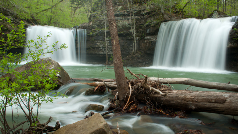
At 15.4 miles long, this more rugged and partly gravel route on the eastern edge of Ozark-St. Francis National Forest is off the beaten path, but also one of the best ways to see some of Arkansas' best waterfalls. Aptly called Falling Water Falls — there's no mistaking what you're in for here — the route's most impressive cascade doesn't even require any hiking to reach, as it's beautiful viewed right from the road. "Lots of hidden gems through the whole drive so take your time and keep yours eyes open," wrote a visitor on Alltrails after a December visit. "Wintertime added more views due to lack of foliage and added an unexpected treat because of the ice and icicles."
The route starts a few miles west of Sand Gap, which sits at the junction of AR 123, 7, and 16. You'll take AR 16 east, past the tiny hamlet of Ben Hur, at which point you'll head south and want to keep an eye out for Upper Falling Water Road, where you'll take a sharp left. This narrow, paved road heads through the trees for gorgeous views, especially in the fall. You'll follow this north until you connect onto Richland Creek Road, where you can camp at rustic sites in Richland Creek Recreation Area and explore the area's small waterfalls and picturesque bluffs.
Blue Buck Knob Scenic Byway, Missouri
Through Missouri's Mark Twain National Forest, the 24-mile Blue Buck Knob Scenic Byway is an opportunity to enjoy rolling countryside and forested hills. The route combines County Road AP, SR 181, and SR 76 in a north-south direction that begins and ends at the national forest boundary. Keep an eye out for Indian Creek Overlook and Blue Buck Overlook, plus Noblett Lake Recreation Area, which is a great spot to stop for a picnic, birdwatching, a scenic paddle, and camping. With trees closely lining the road much of the way, it's another gorgeous place to go leaf-peeping in the fall, with photogenic scenes of woodlands and streams.
"Very pretty and lots of turns and ups and downs," a visitor shared on Alltrails after traveling through the area during the summer.
Methodology
To round up the most scenic byways in the Ozarks, we researched regional tourism sites like Arkansas.com, OnlyinArk.com, ARKOKHiker.com, VisitPulaskiCounty.org, and TravelOK.com to find information about formally recognized scenic byways. The drives listed above encompass treks that can be scheduled over the course of a few days to short stints that can be easily accomplished in an afternoon. For some specific information and data, we consulted organizations like The New York Botanical Garden, the National Scenic Byway Association, the U.S. Forest Service, ARDOT.gov, U.S. Army Corps of Engineers, NPS.gov, and ScenicByways.info. We gleaned additional information about amenities and access from TheRoute-66.com, AdventureCycling.org, OzarkRides.com, Recreation.gov, and ArkansasStateParks.com, plus official sites like AmericasCave.com and TheShepherdoftheHills.com for specific attractions. We also relied on highly rated spots with great reviews via on Alltrails and Google. While parts of the Ozarks can be found in Illinois and Kansas, the vast majority of these beautiful mountains can be found in Missouri, Arkansas, and Oklahoma, so our roundup is restricted to these states.