Australia's 11 Prime Attractions For Tourists To Explore
The Land Down Under is more than just a country — Australia is also an island continent with some of the most extraordinary biodiversity on Earth. Australia's coastline spans well over 21,000 miles and borders three different oceans. Needless to say, it boasts countless beaches — to experience them all, you would need to visit a different beach every day for over 27 years. Plus, the nation is home to over 750 species of reptiles, 250 species of marsupials — including 34.3 million kangaroos — and an estimated 70 million sheep.
With its vast landscapes and one-of-a-kind destinations, planning a trip to see the best of Australia can feel overwhelming. Thankfully, we have done the hard work for you by rounding up Australia's most fascinating destinations that you can't afford to miss. We spoke to local Aussies, read hundreds of traveler reviews, and perused the destinations applauded by international organizations like UNESCO. We narrowed down the 11 best attractions for tourists to explore in Australia, based on their remarkable natural beauty, cultural value, and opportunities to see native animals.
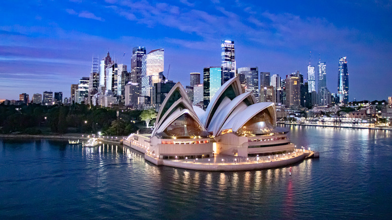
Sydney Opera House, New South Wales
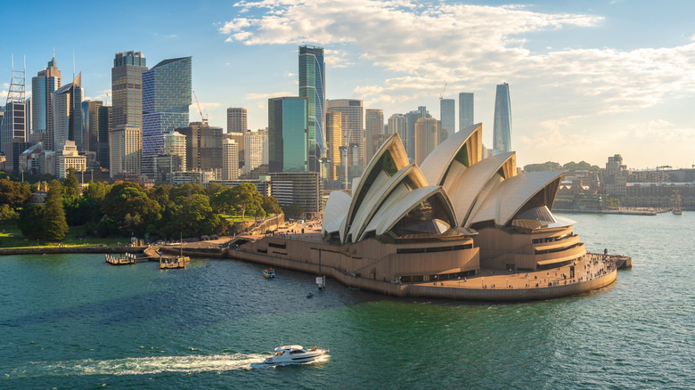
There may be no place as iconically Australian than the Sydney Opera House in the state of New South Wales. Located on the coast of Sydney Harbor just 20 minutes from the Sydney Airport, this spectacular structure stands as an important national symbol. Every year, the venue hosts 1,800 performances and welcomes around 11 million visitors. On New Year's Eve, colorful fireworks light up the sky overhead, making for a postcard-worthy scene.
Designed by Danish architect Jørn Utzon, the Sydney Opera House reinvented the rules of 20th century construction. At the time of its inception, the building's white shell roof was both incredibly unique and difficult to build. Now, decades after its doors first opened in 1973, the structure remains one of the era's great engineering feats, standing as a UNESCO World Heritage Site.
To visit the Sydney Opera House, visitors can purchase tickets to one of its spectacular operas, musicals, or children's shows. Alternatively, you can sign up for one of the destination's many tours, which range from architectural to artistic to theatrical. Prices for these experiences vary quite a bit, with a backstage tour of the opera costing around $199 AUD, or approximately $130 USD per person. Other offerings such as artistic drawing workshops are free, but guests are limited to two tickets only. Visitors can also enjoy dinner and a show at one of the opera house's four eateries or the pre-show lounge.
Great Barrier Reef, Queensland
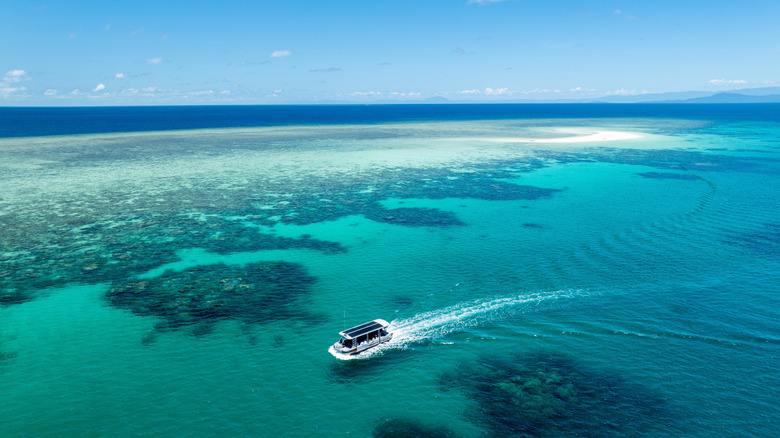
Located off the coast of Queensland, Australia, the Great Barrier Reef requires practically no introduction. As the largest span of coral reefs on Earth, this destination can be spotted from outer space. A UNESCO World Heritage Site, the reef is home to 1,500 types of fish and 4,000 mollusk varieties. Its turquoise blue waters draws admirers from all over the world, and the species that reside below its surface attract snorkelers and scuba divers alike. It is no wonder that the Great Barrier Reef stands among the seven wonders of the natural world.
To visit the Great Barrier Reef, travelers can head to one of the many towns that dot the northwestern coast of Queensland. The easiest point of entry is arguably Cairns as the city is home to the Cairns Airport, with international flights from places like Bali, Singapore, Auckland, and many more. Compared to other nearby towns, Cairns is famed for its budget-friendly lodging options. Visitors can then book snorkeling adventures and glass-bottom boat tours from Cairns.
Luxury travelers, meanwhile, might consider flying into one of the region's smaller but pricier airports. The Hamilton Island Airport provides proximity to chic accommodations like Beach Club, an adults-only resort overlooking the Coral Sea. Private yacht charters and diving trips are also available. The reef views at the Hamilton Island Golf Club are also said to be spectacular.
Uluru-Kata Tjuta National Park, Northern Territory
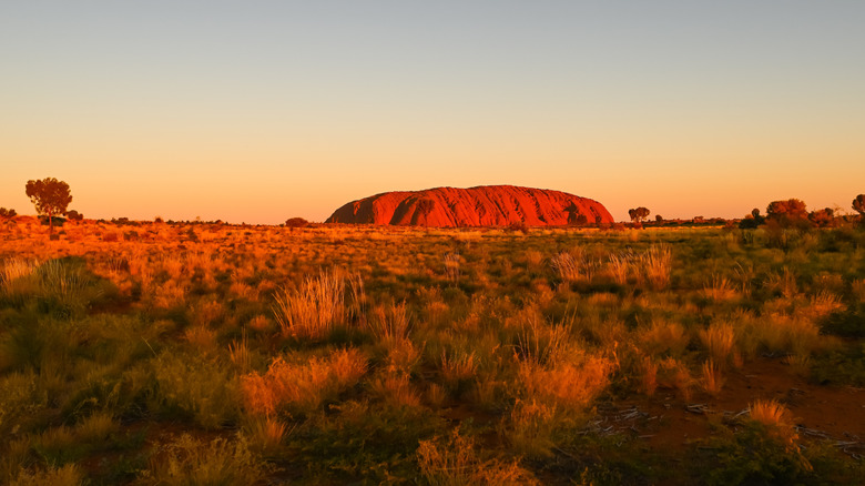
Australia's famed Uluru-Kata Tjuta National Park boasts some of the world's most stunning geological formations. Its crown jewel — the Uluru monolith, or Ayers Rock — stands at an impressive height of 2,831 feet. Its stunning sandstone ridges create a striking visual against the surrounding plains. In the evenings, they reflect the colors of the setting sun, so be sure to pack a camera for this stunning photo op. Visitors who hope to visit this site up-close can hike around the Uluru by completing the 6.71-mile loop around its base.
Beyond Uluru-Kata Tjuta National Park's geological value, the destination holds important cultural significance for the Aboriginal Aṉangu peoples. Throughout history, the monoliths in the park have inspired different elements of traditional Aṉangu stories and spirituality. For this reason, the park is a UNESCO World Heritage Site. To learn more about local history, visitors can sign up for a Mala Walk. Led by local rangers, this 1.2-mile route takes visitors past some of the region's most important historical rock artwork and ancient cave settlements.
To visit Uluru-Kata Tjuta National Park, drive 30 minutes from the Uluru/Connellan Airport in Yulara. Alternatively, you can embark on a scenic road trip through Australia's most famous destinations in the Outback. Known as the Red Centre Way, this trip also covers Alice Springs and the Kings Canyon. At the time of writing, daily park passes cost $38 AUD, or $25 USD per adult.
Franklin-Gordon Wild Rivers National Park, Tasmania
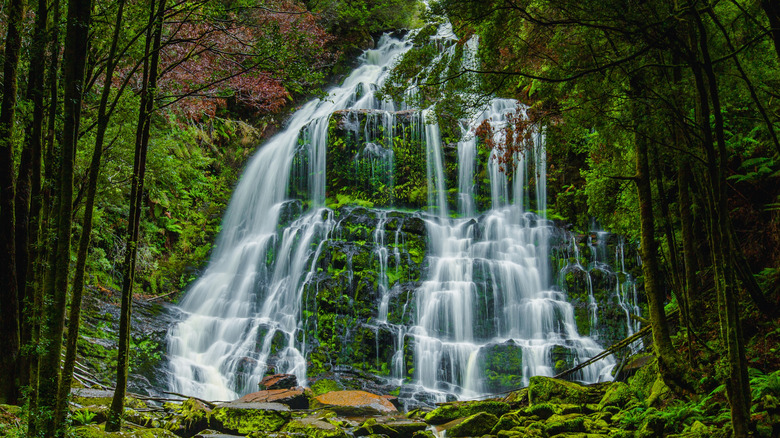
There are tons of reasons to visit Tasmania, and Franklin-Gordon Wild Rivers National Park is one of them. Although Tasmania is by far Australia's smallest state, it's also one of the most fascinating. Franklin-Gordon offers an intriguing mixture of rushing rivers, churning waterfalls, and verdant rainforests. The local fauna is also truly unique, with platypuses roaming the wetlands and Tasmanian devils prancing in the brush. Because of this, the Tasmanian wilderness has been recognized by UNESCO.
To experience it all, visitors can hike one of Franklin-Gordon Wild Rivers National Park's wonderful trails. The path to Nelson Falls is particularly stunning, as it winds 0.86 miles through a lush rainforest. The trail culminates at a mossy ridge covered in cascading waters. Folks looking for a longer adventure may wish to tackle the challenging multi-day Frenchman's Cap trail, although registration with local authorities is required before departing. The whole 33-mile adventure can take up to five days to complete, but some previous visitors report only hiking the first few miles to check out the iconic suspension bridges.
Day passes at the Franklin-Gordon Wild Rivers National Park will set you back $47.70 AUD, or about $32 USD for a vehicle of up to eight people. Vacationers, however, may opt for the holiday pass, which grants access to all Tasmanian national parks for two months. To get to Franklin-Gordon, fly into Hobart International Airport — from there, the drive to the park is close to three hours.
Downton Melbourne, Victoria
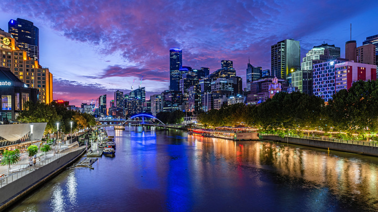
Australia may be famous for its incredible natural wonders, but that doesn't mean that it lacks exciting city life. Melbourne embraces a total of 5.35 million residents and counting. This means that the city also encompasses quite a bit of diversity, with eateries, museums, and public spaces that appeal to a wide range of tastes and interests. The charming streets of downtown Melbourne await.
Foodies will love the South Melbourne Market and its collection of delectable stands. Founded in 1867, this market sells all kinds of mouthwatering eats, from freshly-baked croissants to enormous lobster dinners. The National Gallery of Victoria is perfect for travelers who want to explore their artsy side and peruse a collection of renowned Australian and international artwork. Its rotating calendar of exhibitions have featured everything from impressionist paintings to Australian jewelry. While some parts of the museum are free to visit, others require tickets. The Royal Botanic Gardens Victoria is also considered one of Australia's best tourist destinations. There, travelers can view a 19th-century garden with 360 varieties of flora, free of charge.
To get to downtown Melbourne, drive approximately 30 minutes from the Melbourne Airport. While the city offers accommodations to suit a wide variety of budgets, June is considered the most affordable month to visit. Keep in mind that this is also the height of winter in Melbourne, with average daily temperatures of 57 degrees Fahrenheit.
Kangaroo Island, South Australia
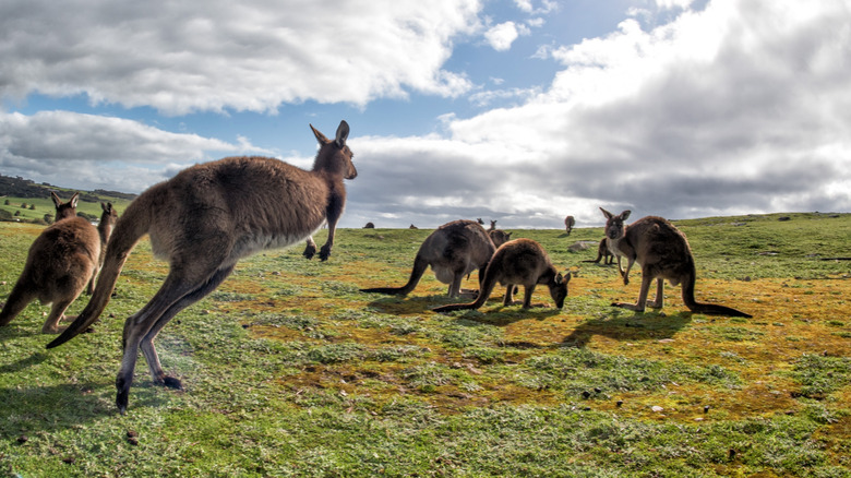
Australia is home some of the most unique fauna in the world. It is the only place on Earth where you can see kangaroos grazing in a field, or koalas napping in the trees. To view these majestic beasts in real life, travelers can head to Kangaroo Island. Situated 70 miles off the shore of Adelaide, South Australia, this island spans over an impressive 1,698 square miles. This means that it can take several days to get a feel for this unique destination. However, previous visitors have said that even a day trip to Kangaroo Island is totally worth the journey.
The main attraction is, of course, the wildlife. Kangaroos, koalas, wallabies, and sea lions all reside on this scenic stretch of land. For the best wildlife viewing opportunities, the local tourism office recommends planning a road trip of the island. Potential stops include watching the seals at Seal Bay and meeting the koalas at Hanson Bay Wildlife Sanctuary. While driving, travelers can expect to see kangaroos hopping along the side of the road. The fastest way to get to Kangaroo Island is to fly into the Kingscote Airport in Cygnet River from Adelaide, as the journey takes only 30 minutes. For a slower-paced adventure, drive roughly 90 minutes from Adelaide to Cape Jervis and embark on the 45-minute ferry to Kangaroo Island.
Horizontal Falls, Western Australia
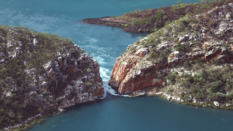
When most people imagine a waterfall, they picture it flowing in just one direction. At the Horizontal Falls in Western Australia, however, the water cascades both ways. This truly spectacular natural occurrence takes place in two different gorges in Talbot Bay. When the ocean tides come rolling in, the waterfall moves in the same direction. Then, when the tides pull back, the falls change direction, allowing a unique transition to take place. Previous visitors have said that watching the water move through the gorge is absolutely mind-blowing. Even famous biologist David Attenborough called it "one of the greatest natural wonders in the world."
The best way to visit the Horizontal Falls is by taking either a boat tour or a seaplane excursion. These adventures depart from nearby towns like Broome or Derby. Visitors should note that these guided tours can take hours to complete. For example, an excursion from Broome to Horizontal Falls can last up to six hours, often with a hefty price tag involved. However, the experience is unforgettable, as this natural marvel is truly one-of-a-kind. To start your adventure, fly into the Derby Airport or Broome International Airport and make your way to the town center.
Bondi Beach, New South Wales
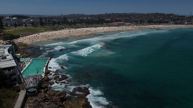
Whether you're a first-time or longtime visitor to Australia, you've likely heard of Bondi Beach. Nestled along the coastline of the Sydney suburb of Bondi, this iconic Australian beach is renowned for its lively atmosphere and world-class surf. With its gorgeous stretches of sugar white sand and roaring blue waves, Bondi Beach seems like it was created to be postcard-perfect. Its shoreline is dotted with a myriad of beach goers tanning, stretching, playing volleyball, and more. The fact that it draws overs 2.6 million tourists annually only adds to the draw, as the people-watching at Bondi is said to be unparalleled.
Located just 9 miles from Sydney Airport, Bondi Beach is a popular spot for surfing, sunbathing, and making sandcastles. It's also home to some more unique offerings like the Bondi Baths. This century-old historical landmark features a 164-foot swimming pool bordering the Pacific Ocean. Land lubbers might prefer the Bondi to Congee walk, which winds along 3.7 miles of rocky coastline between Bondi Beach and Congee Beach. Visiting Bondi Beach is free of charge, although swimming at the Baths comes with a small admission fee for adults and children.
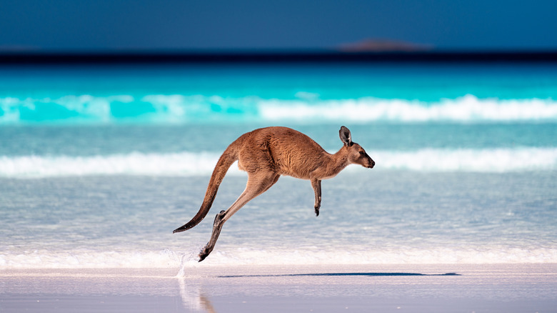
Lucky Bay Beach, Western Australia
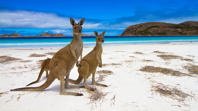
Bondi Beach may be the most famous beach in Australia, but Lucky Bay Beach might just be the prettiest. Many visitors call it one of the best beaches in all of Australia, and in 2023, it was ranked the most beautiful beach in the world, and it's not hard to imagine why. As a part of Western Australia's gorgeous Cape Le Grand National Park, Lucky Bay Beach boasts a natural environment far from the chaos of beachside bars and sky-high hotels. Instead, it offers clean white sands and pristine turquoise waters that beckon visitors to take a dip. Its pristine landscape also makes it a safe home for kangaroos, which are known to hop along the shore. Grab a towel, a camera, and a cooler with plenty of water. Then, get ready to spend the day relaxing on the serene, unspoiled shores.
To visit this point of immense natural beauty, beach-goers must secure a day pass to Cape Le Grand National Park. The price of $17 AUD, or $11 USD, covers the entrance fee for vehicles of up to 12 people. Admission is cheaper for those visiting on a bus tour. This Australian shoreline is out of this world, making the time and money it takes to get there totally worthwhile. To plan your trip to Lucky Bay Beach, fly into the Esperance Airport, located an hour from the national park.
Adelaide Hills, South Australia
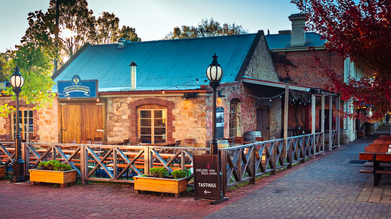
Of Australia's top wine destinations, Adelaide Hills is among the most scenic. Situated just outside of South Australia's booming capital city of Adelaide, this wine region has become a popular weekend getaway. Its location in the Mount Lofty Ranges offers breathtaking views of rolling hills, and the many vineyards throughout the region give it a tranquil, pastoral feel. Wine aficionados will especially love this destination for its 90 different labels. To explore them, visitors can stop by some of the Adelaide Hills' most prominent wineries to sip a crisp Austalian sauvignon blanc or the "heartbreak grape," pinot noir.
To get to the Adelaide Hills region, drive an hour from the Adelaide Airport or 45 minutes from Adelaide's city center. Travelers can enjoy a day trip to the wineries, or spend the night in one of the many small towns in the Mount Lofty Ranges area. For winery tours with a side of arts and culture, head to the town of Crafers, where local artists display their work on the main street. Those in search of European charm might head to the German heritage village of Hahndorf. There are countless towns and villages to discover in Adelaide Hills, each boasting their own unique character and attractions.
Carnarvon Gorge, Queensland
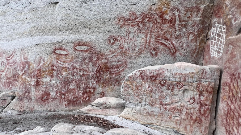
To get a feel for ancient Aboriginal artwork, travel to the famous Carnarvon Gorge in Queensland, Australia. Located in Carnarvon National Park, this gorge boasts a stone wall with approximately 2,000 examples of rock art. Visitors can see ochre stencils of ancient handprints that are roughly 3,650 years old. Boomerangs, axes, and other tools also make an appearance on the walls, offering travelers a unique glimpse into a distant bygone era.
The best way to view this incredible sight is by completing the Art Gallery Walk. This 6.7-mile hike whisks visitors right past the 203-foot wall where the most impressive art remains. Travelers are encouraged to budget a full four hours for the experience, as there is plenty of art to discover. The site is also rich with history as an important spiritual and ceremonial center. "Otherworldly beautiful," reads one review on Tripadvisor. "Absolutely stunning nature and incredibly varied!"
Day passes at Carnarvon National Park are free, as with all national parks in Queensland. While Brisbane and Rockhampton are the nearest major cities, both are a long drive from the park — consider a local flight to Roma Airport in Roma, Queensland instead. Keep in mind that the region gets very hot in the summer, and visiting during the cooler and drier months between April and October is recommended.
Methodology
Australia's diverse landscape and fascinating cultures makes choosing the 11 best tourist attractions a challenging task. That being said, a few destinations undoubtedly stand out. We began by focusing on the nation's UNESCO World Heritage Sites, including the Sydney Opera House, the Great Barrier Reef, and the stunning Tasmanian wilderness that can be experienced at Franklin-Gordon Wild Rivers National Park. The organization has also recognized the cultural significance of Uluru-Kata Tjuta National Park.
We also consulted lifelong Australian residents as part of our research, and Lucky Bay Beach came at the top of the list of local suggestions. Downtown Melbourne was also noted as one of the most vibrant urban areas in the country. These destinations also come highly recommended on trusted review platforms like Tripadvisor and Google Reviews. Various travel blogs and online reviews recommend Adelaide Hills and Bondi Beach as must-visit locations for tourists. Horizontal Falls is widely considered one of the most fascinating natural phenomenons on the continent, and Carnarvon National Park has received hundreds of excellent reviews.