The Rhine Valley's 12 Best Attractions To Explore During Your Visit
Extending more than 765 miles, the grand Rhine River hosts some of Europe's most beguiling destinations. Starting in the Swiss Alps, it works its way north toward Liechtenstein and flows straight through Lake Constance, home to picturesque cities like Lindau and a prehistoric treasure that's Europe's most underrated ancient marvel. From there, it meanders west toward Basel, Switzerland, before hanging north again into Germany, where it passes through cities like Mainz, Bonn, and Cologne before crossing into the Netherlands and eventually emptying into the North Sea. (Phew!) It's no wonder this river has had such a massive influence on the continent, from trade and industry to architectural heritage and cross-cultural connections.
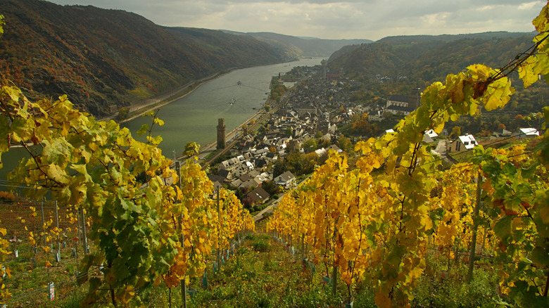
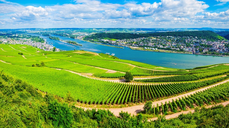
Along the beautiful stretch known as the Loreley Valley or Upper Middle Rhine Valley — often referred to simply as the Rhine Valley — storybook Europe shines. Medieval towns, fortified islands, picturesque bridges, and postcard-worthy landscapes await around every bend, especially between Bingen and Bonn. Today, the span from Bingen up to Koblenz is a UNESCO World Heritage area that brims with vineyards, churches, slate-roofed castles, and dramatic terrain that has long inspired poets and artists. It's a perennially popular route for all-inclusive river cruises like those offered by Viking, Avalon Waterways, and other large cruise companies, and of course, seeing this area from the water may be an obvious choice. That said, there are numerous places one can easily connect to via car, ferry, or bike, whether you're looking for a day trip or a multi-day itinerary. Read on for 12 of the Rhine Valley's very best attractions.
See Rheinfels Castle
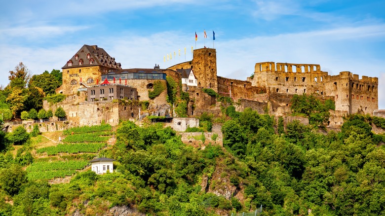
A fortified castle sitting loftily on the bank of the Rhine in St. Goar, Rheinfels Castle is one of the most prominent and historic medieval castles along the river, dating to 1245. It was added onto over time, with strengthened walls and defensive towers, plus a network of underground passages; the castle was at its height of influence in the 14th and 15th centuries. It even remained largely intact after numerous sieges during the Thirty Years' War of 1618 to 1648, but fast-forward to 1797, and it couldn't withstand a major assault by French Revolutionary forces, leaving it a shell of its former self. After that, the Prussians gained control of the ruins. Then in 1925, the city of St. Goar assumed ownership, maintaining it as a tourist attraction that continues to be a must-see destination along the Rhine.
Standard adult admission to the castle is €6. The experience through the ruins' remaining rooms and buildings is largely self-guided, but there are tours offered on weekends and public holidays at 11 a.m., 1 p.m., and 3 p.m., which are included with your ticket. A shuttle from St. Goar offers an express way to get up the hill, but scaling the promontory on foot, which takes about 20 minutes, is a great way to take in the view. The shuttle option runs every 30 minutes from May through October from the central Marktplatz. If you have a car, there is a small parking lot at the castle. And to really immerse yourself in the experience, book a night or two at Hotel Schloss Rheinfels, a 4-star accommodation built in 1973 that incorporates a modern building into some of the ruins and offers similarly remarkable views of the river, surrounding vineyards, and the town below.
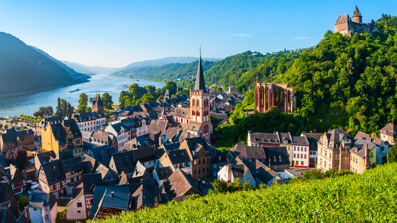
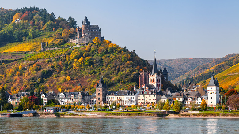
Wander the streets of St. Goar
Beyond Rheinfels Castle, there's plenty more to explore in St. Goar, which also makes for a great place to orient yourself if you're exploring the region, as it's also home to the Loreley Visitor Center. Loreley Valley, another name for the Middle Rhine Valley around St. Goar, is one of the most picturesque stretches of the river, and one of the reasons it's among the best destinations you can't skip on a trip to Germany. It's named for a mythical figure, popularized in an early 19th-century poetic work by Clemens Brentano, about a woman who surrendered herself to the Rhine River after disappointment in love. There, she transformed into a siren whose song, echoing off a huge rock, lured unsuspecting fishermen to their deaths. Keep an eye out for this rocky outcrop above St. Goar aptly called Loreley Rock.
St. Goar's Stiftskirche (Collegiate Church) is a bright landmark worth composing into photos of this quaint medieval town or spotting from the Oberwesel-St. Goar leg of the Rhine Castles Trail. Stretching nearly 120 miles, the hiking route is divided into 13 stages. But zooming back in to town, don't miss a treasure of a shop called Stefan's Wine Paradise, a family-run business featuring wines and brandies made from local grapes. Or find a unique, handcrafted souvenir that can hardly get more German at Montag Steins and Clocks, which specializes in traditional ceramic beer steins and wooden cuckoo clocks.
Stroll around Bacharach
An incredible medieval village, Bacharach is full of half-timber houses and walkable, narrow streets overlooking the Rhine. It used to be fortified by a monumental wall that stretched up to a hilltop castle. Remains of the wall can be explored on foot today, along which you can peer up at half a dozen defensive towers — a fraction of the 16 that once protected the city. One of these, known as Postenturm, used to punctuate the northern city wall, and today, nestled amid grape vines, it offers one of the most iconic views of the city from its slightly wonky mezzanine. Spot the Gothic ruins of the Wernerkapelle, or Werner Chapel, on a hill slightly elevated above the rest of the town, which is also an atmospheric local landmark to explore.
Burg Stahleck, or Stahleck Castle, was built around the turn of the 12th century, and it was substantially expanded in the mid-14th century with towers and strengthened walls. It's a steep climb to the castle, but the trek is worthwhile for the spectacular views over the city, across steep vineyards, and over the river. You can also take an extra long break before heading back down the hill by extending your stay overnight, as Burg Stahleck is currently operated as a family-friendly youth hostel. Then, round out the evening with traditional German fare at Altes Haus, a restaurant in a house that was begun in 1368 and finished in its present elaborate, half-timbered state in 1586. It's a rare example of an affluent burgher house that survived Bacharach's unfortunate string of devastating town fires in the 19th and 20th centuries.
Tour Marksburg Castle
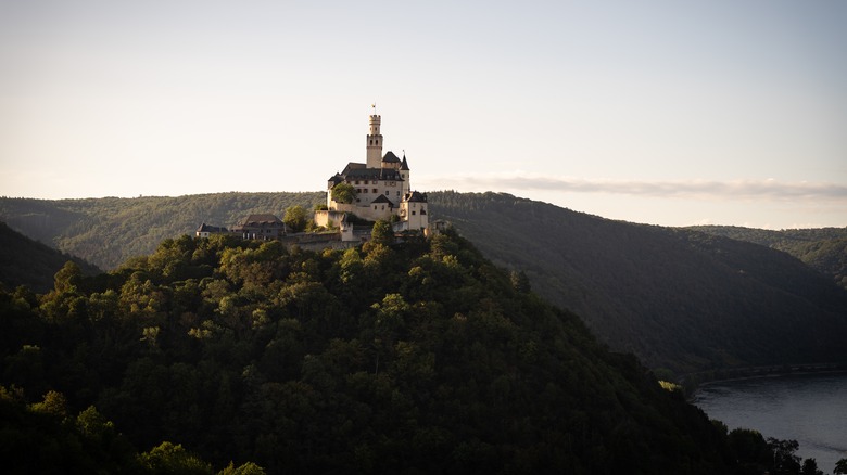
Marksburg Castle in Braubach is an instantly recognizable feature of the landscape, standing tall atop a hill at a bend in the river that affords it beautiful — and at one time strategic — views in both directions down the Rhine. Perched on an outcrop, Marksburg is easily among the most fairytale-like castles in all of Europe. It's a stunning bit of 800-year-old architectural heritage that was first built as a Romanesque complex, later added onto with prominent Gothic elements, and then further fortified with ramparts and other defensive structures to make it a proper fortress. It's historically been used as a state prison and a barracks for soldiers, and today it's preserved as a museum and also serves as the headquarters for the German Castles Association, which is certainly apt! Visitors are able to experience Marksburg via a guided tour, which lasts around 50 minutes and is offered in English every day at 1 p.m. during the summer. Stop for lunch at Marskburg Schanke, the castle's on-site tavern, which is worth it for the throwback medieval atmosphere.
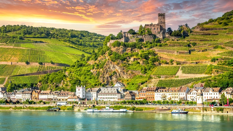
Explore Rheinstein Castle
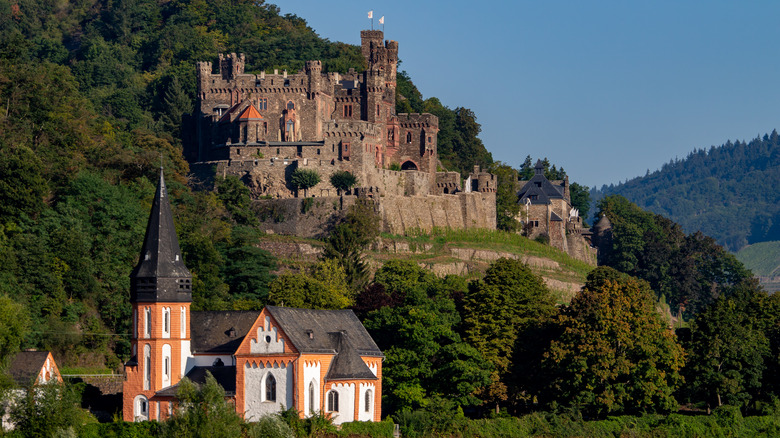
One example of a relatively recent castle along the Rhine — albeit still boasting a richly layered history — is the imposing Rheinstein Castle, located just about 3.5 miles northwest of Bingen and across the river from the village of Assmannshausen. Built on the ruins of an original structure dating to around 1290, which was expanded in the mid-14th century, the castle we see today is an architect-designed 1829 construction that takes its name from the German for "Rhine stone." It's certainly fitting that it sits on a rocky outcrop high above the river, where its views were at one time enjoyed by dignitaries and royalty like England's Queen Victoria and Russia's Empress Alexandra Feodorovna.
For the past few decades, Rheinstein Castle has been privately owned by the Hecher family, who still live there, but parts of it are open to the public for self-guided tours. Grab an informational brochure before you walk through the gardens, stables, chapel, a prominent hall, the tallest tower, and other spaces. The on-site restaurant with its outdoor patio is a treat during the warmer months, with wonderful views down over the river, and if you prefer to stay awhile, book one of a few comfortably furnished rooms in a guesthouse or the top two floors of a tower you'll have all to yourself.
Sample local wine in Oberwesel
From a 14th-century church called St. Martin to the impressive Schoenburg Castle situated high on a hill, the town of Oberwesel doesn't lag when it comes to historic landmarks. Surrounded by vineyards, which you'll see up and down the Rhine Valley, Oberwesel is a fantastic place to sample local vintages. Every September, the main market square comes alive with the annual wine market, presented by local winemakers and... witches?
Akin to state fair queens in the U.S., Oberwesen has a tradition of selecting a Weinhex, or "wine witch," a representative of the region's vino. There's even a night, called Weinhexnacht, devoted to the big reveal. Every year on April 30, a new Weinhex emerges from a barrel in the market square to much fanfare, and there are plenty of wines on offer from local makers. Then, when September rolls around, the Weinhex — and past witches — join visitors in the town center for the much-anticipated multi-day festival. Be sure to try Riesling, which is a regional specialty. Visit established local winemakers like Lanius-Knab and Albert Lambrich any time of the year.
Boat out to Pfalzgrafenstein Castle
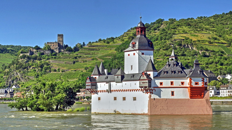
Unlike a lot of the Rhine Valley's most famous castles, Pfalzgrafenstein is situated in the river rather than far above it. Located near Kaub, just north of Bacharach, Pfalzgrafenstein began its story about eight centuries ago as a single tower on a small island. In the 14th century, additional walls and towers were added to amp up its presence and further fortify it against any possible attacks. For such a small building, it features a remarkable number of turrets and viewpoints for a 360-degree panorama of the area from various levels and towers. Its original use was as a customs post, or toll booth, exacting fees from passing river traffic to benefit local feudal lords. Its position in the river made it unavoidable for passing traffic and gave those inside a clear look at who was sailing by.
Pfalzgrafenstein is only reachable by ferry, which runs back and forth between Kaub and the island during opening times. While it's closed entirely in December and January, the castle is open on weekends during the rest of the year, with the addition of Thursdays and Fridays between March 15 and October 31. Standard adult admission is €8, which includes the ferry ride. Kids up to 5 years old are free, and those 6 to 17 are €4.
Visit museums in Koblenz
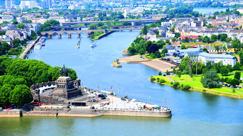
At the confluence of the Rhine and Moselle Rivers, which meet at a spot known as the Deutsches Eck, or German Corner, sits the city of Koblenz. This is a great place to make a base camp because it's connected via water, rail, and road to so many other nearby Rhine Valley attractions while offering a rich diversity of museums and cultural landmarks of its own. Orient yourself from the air with a ride on the Koblenz Cable Car, which connects St. Castor's Basilica — the oldest church in Koblenz — to the colossal Ehrenbreitstein Fortress. This can also be reached via a steep funicular that offers equally great views.
Koblenz is home to a number of great museums like Rhein-Museum, which sits at the foot of Ehrenbreitstein Fortress and highlights all aspects of life on the Rhine throughout history. Across the river, art-lovers will enjoy a stop into the Ludwig Museum, which sits near the Deutsches Eck and emphasizes contemporary art in a historic building. And just a 15-minute walk away from there, the Mittelrhein-Museum highlights two millennia of human creativity with a collection of nearly 2,000 paintings and more than 11,000 prints. For a little detour from downtown, Stolzenfels Castle, a beautiful 19th-century pile on a hillside that embodies the Romantic era, is less than four miles down the road from central Koblenz.
Wander the World Heritage Garden Route
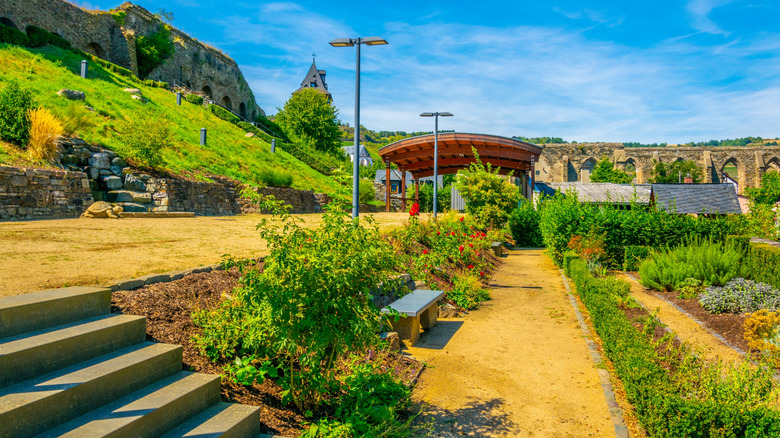
Along with palatial residencies usually come beautiful gardens, and the Rhine Valley features more than 30 gardens that are open to the public for exploring and relaxing along the World Heritage Garden Route. These range from formal, meticulously maintained castle and church gardens like the Blumenhof, or Flower Courtyard, of the Basilica of St. Castor in Koblenz and the Renaissance Garden of Philippsburg Castle in Braubach, which faithfully recreates its own design from 1607. In Oberwesel, the City Wall Garden takes root on Michelfeld hill, combining remnants of the town's defensive walls with picturesque flowers and shrubs. Participating gardens are signposted around the region, but if you want to research destinations in advance, plan your botanical-spotting route via the Upper Middle Rhine Valley World Heritage website.
Bike along the Rhine Cycle Route
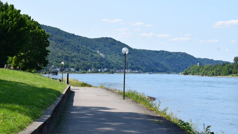
There really is nothing quite like experiencing a place on two wheels, letting the breeze cool you on a sunny day, and riding at a pace that allows you to thoroughly take in your surroundings while still covering a lot of ground. That's where Europe's scenic, beginner-friendly bike route between Switzerland and the Netherlands comes in, boasting unparalleled views of the Rhine Valley. In all, the Rhine Cycle Route, which is also known as EuroVelo 15, covers 900 miles through six countries. It sticks close to the river, so its terrain is mostly flat, making it surprisingly easy and family-friendly for shorter rides. Broken up into seven distinct stages, the two that will be most interesting to explorers of the Middle Rhine include the northern stretch of the route between Karlsruhe to Bingen, then Bingen to Cologne. Take the path in bits and pieces at your own pace or, if you want an immersive, all-inclusive experience, book a multi-day guided cycle tour that includes parts of the Rhine Cycle Path with an outfit like BikeTours.com.
See Rhine in Flames
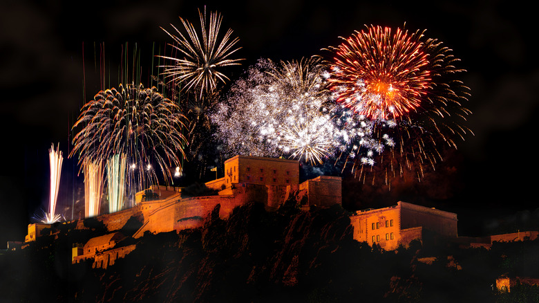
A summertime tradition that thematically connects communities along the river, Rhein in Flammen, or Rhine in Flames, is an annual event that illuminates the valley with fireworks, events, and music. Throughout the summer, approximately once per month, the festivities kick off in different locations along the river. Bonn kicks off the season in May, followed by Bingen-Rüdesheim in July, Koblenz in August, and both Oberwesel and St. Goar about a week apart in mid-September. Some cruise operators offer special itineraries to see the firework displays from the water, or you can visit on dry land via the cities' promenades and other elevated locations. A flotilla parade in Koblenz often includes up to five dozen passenger boats, and the city extends the fun with its annual summer music festival at the same time.
See the Rhine Valley by rail
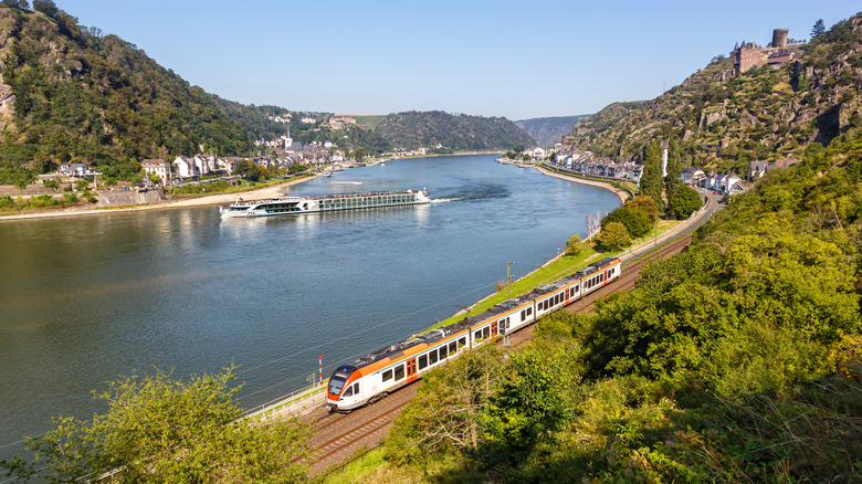
It may seem like a no-brainer that boat travel through a river valley is a great way to go when deciding how best to approach your visit. The stretch of the Rhine Valley that extends approximately 36 miles between Mainz and Koblenz really takes most of the region's aesthetic and historic thunder. Summertime crowds can be a real sticking point, though, so one option is to take a blissfully crowd-free winter cruise up this enchanting European river gorge. But you might also consider a shoulder season visit, like between March and May or September to early November. By December, Christmas markets transform these quaint medieval towns into must-see cold-weather destinations. A boat cruise might be a scenic German journey that Rick Steves says never gets old, but a train journey is another wonderful — and cost-effective — option.
One popular route connects the easy-to-reach hub of Cologne with Koblenz. This journey can take less than an hour and costs around $8.50 to start, making it a great option if you've made your base camp in Cologne and are taking a day trip. You can also continue on to a number of small Rhine towns like St. Goar or Bacharach. The latter, for example, is reachable by rail in about 2 to 2.5 hours from Cologne, and fares average around $50 one-way. The scenic Rhine Valley Line connects Mainz to Koblenz, conveying you along the river and past numerous vineyards, small towns, and through just a few tunnels.
Methodology
The Rhine Valley is a beautiful and highly touristic region that embodies Germany's history, heritage, and of course, romance. It's no small task to narrow down just a dozen must-see places, but to make this list, we referenced regional tourism sites like Germany.travel, VisitWorldHeritage.com, Romantischer-Rhein.de, and Tor-Zum-Welterbe.de. For specific information, such as admission prices and historical context, we researched official sites including Burg-Rheinfels.com, Burg-Rheinfels.org, Marksburg.de, Burg-Rheinstein.de, Oberwesel.de, Welterbe-Mittelrheintal.de, Rhein-in-Flammen.com, and more. We also consulted UNESCO, Britannica.com, RailEurope.com, Great-Castles.com, and RickSteves.com for additional information and data.