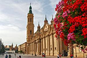
12 Top-Rated Day Trips from Madrid
Day trips outside Madrid offer a welcome break for tourists seeking a change of scenery and pace. After exploring Madrid's busy streets and the seemingly endless galleries of its art museums, tourists will enjoy breathing in the fresh air of the countryside and discovering smaller cities with a more relaxing atmosphere.
Within less than an hour's journey, travelers can escape to peaceful mountains, charming historic towns, and monumental royal palaces of the Castile region. Nearby are three UNESCO-listed sites: El Escorial, the 16th-century monastery-palace; the elegant historic town of Aranjuez; and the university town of Alcalá de Henares.
To admire typical Castilian architecture and experience the regional traditions, two exceptional places to visit are Manzanares el Real, famous for its castle, and Colmenar Viejo, known for bullfighting. Several destinations are in the beautiful Sierra de Guadarrama, including the Puerto de Navacerrada ski resort.
Not far south of Madrid is the UNESCO-listed medieval hilltop city of Toledo, and to the north are all the attractions of Segovia, with its magnificent Roman aqueduct and fairy-tale castle. Slightly farther away is the designated historic-artistic site of Sigüenza, with an impressive medieval castle that is now a luxury hotel.
Plan your excursions with this list of the top day trips from Madrid.
- 1. El Escorial Monastery and Palace
- 2. Toledo
- 3. Royal Palace of Aranjuez
- 4. Segovia
- 5. Sigüenza
- 6. Alcalá de Henares: The Birthplace of Cervantes
- 7. The Medieval Fortress of Manzanares el Real
- 8. Colmenar Viejo
- 9. Chinchón
- 10. Palacio Real del Pardo
- 11. Puerto de Navacerrada Ski Resort
- 12. Guadalajara
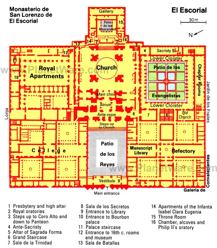
1. El Escorial Monastery and Palace
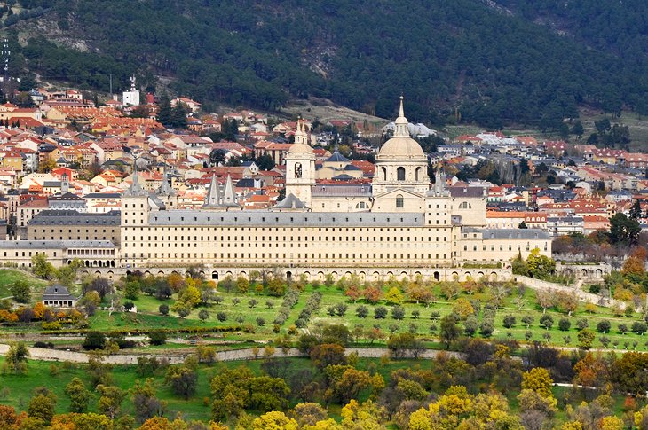
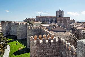
Tourists are pleasantly surprised by this idyllic retreat on the southern slopes of the Sierra de Guadarrama, just 50 kilometers outside of the Madrid metropolitan area. Nestled in the little town of San Lorenzo del Escorial (El Escorial) is the UNESCO-listed Royal Monastery and Palace of El Escorial. The immense monastery and palace complex, with its inestimable treasures of art, is one of the most visited tourist attractions in Spain.
The monastery was built in the 16th century for Felipe II, who dedicated the monument to Saint Lawrence after the Spanish troops defeated the French in the Battle of Saint-Quentin on August 10, 1557. El Escorial was once a center of political power during the Spanish Empire.
From the outside, El Escorial appears more like a fortress than a monastery. The grayish granite complex was designed by Juan de Herrera; the architectural style, known as Herrerian, combines 16th-century Italian classicism with Spanish Baroque details.
Altogether, the grandiose complex has 15 courtyards, more than 2,000 windows, more than 1,000 doors, 86 staircases, 88 fountains, and 1,600 paintings. At its center is the twin-towered church with an awe-inspiring 90-meter-high dome.
Within the palace, the opulent Bourbon Suite includes the state apartments of Charles IV and Maria Luisa of Parma. These rooms display valuable 18th-century furniture, exquisite porcelain, and an enormous collection of more than 300 Spanish and Flemish tapestries.
El Escorial also has a renowned Picture Gallery with paintings by masters such as Guido Reni, Tintoretto, Veronese, José de Ribera, and Albrecht Dürer. Be sure to see Titian's Last Supper and Saint Jerome in Prayer, Hieronymus Bosch's The Crowning with Thorns, Marinus van Reymerswaele's The Money-Changers, and Diego Velázquez' Joseph's Robe. One of the important works is The Martyrdom of Saint Maurice by El Greco.
An easy way to explore the palaces and monastery, as well as see the nearby monuments of Valle de los Caídos, is on the El Escorial Monastery and the Valley of the Fallen tour. This five-hour day trip from Madrid includes a local guide to provide historical background and point out the most important features, as well as transport by air-conditioned coach, and entrance fees. You can combine this with a half-day Madrid sightseeing tour.
Address: Calle Juan de Borbón y Battenberg, 28200 San Lorenzo de El Escorial, Madrid
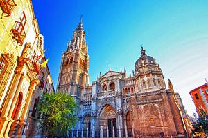
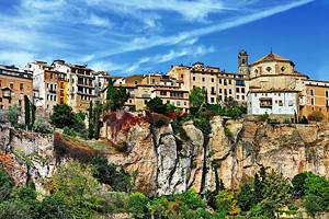
2. Toledo
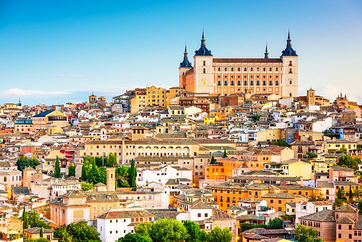
El Greco, the Spanish Renaissance artist who lived and worked here in the mid-16th century, created a celebrated landscape painting (Vista de Toledo) around 1598 to 1599 that captures the medieval hilltop city's captivating atmosphere.
The painting's somber colors and swirling clouds reveal the influence of mysticism, a commonly held spiritual point of view at the time. El Greco uses his imagination to depict the dark, moody feel of a city that is steeped in history.
Three cultures lived together in harmony and thrived in Toledo during the Middle Ages, and today Toledo's top attractions reflect the artistic and cultural legacies of all three: Islamic, Jewish, and Christian.
With the entire city designated as a UNESCO World Heritage Site, Toledo's medieval walls, churches, convents, synagogues, mosques, and labyrinth of narrow stone-paved streets transport visitors several centuries back in time.
Toledo is a one-hour train ride from Madrid, but an easier way to see the city and learn about its heritage is on the Toledo Half-Day or Full-Day Trip. The tour includes round-trip transportation and a walking tour through the city's cobblestone streets. You will have a chance to visit a 15th-century monastery and Santa María la Blanca, an ancient synagogue converted into a church. If you select the full-day tour, you will also walk to the Cathedral of Toledo to see the exterior.
Those who appreciate historic cities may want to stay overnight in Toledo, to more leisurely explore the wealth of cultural treasures. Sure to please the most discerning travelers, the four-star Parador de Toledo offers sweeping views of Toledo's cityscape and modern guest rooms with tiled floors, wood-beamed ceilings, and balconies. Amenities include an outdoor swimming pool and a traditional restaurant that specializes in dishes from the Castile-La Mancha region.
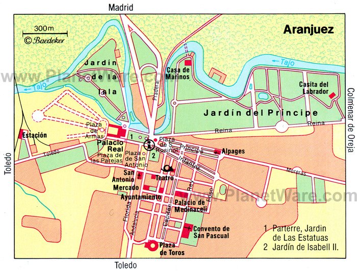
3. Royal Palace of Aranjuez
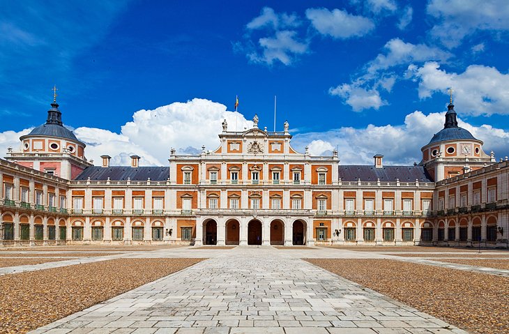
The UNESCO-listed city of Aranjuez boasts a remarkable cultural heritage. In the 16th century, Aranjuez was chosen as a site for the royal summer residence, and the Royal Palace was enhanced in the 18th and 19th centuries under the reigns of Philip V, Ferdinand VI, Charles III, and Charles IV
The historic town center dates to the 18th century and has been well preserved. The geometrically laid-out avenues, tree-lined squares, shaded groves, and Baroque gardens embody the orderly ideas of the Age of Enlightenment.
Surrounded by over 100 hectares of lush gardens, the Royal Palace was built for Philip II in 1560 but was rebuilt in the 1660s. The two-toned brick and stone façade exemplifies the elegant Neoclassical architecture favored by the House of Habsburg (a lineage of the Spanish royal family). The richly decorated interior displays valuable tapestries, fine porcelain, exceptional paintings, and exquisite objets d'art.
Particularly notable features of the palace are the magnificent staircase, the Chapel Royal by Sabatini, and the velvet-clad Throne Room. The dazzling Porcelain Room is lavishly decorated with ornate plaques of Buen Retiro porcelain depicting Chinese scenes, while the Chinese Room is adorned with 200 delicate paintings on rice paper, which were a gift of the Emperor of China to Queen Isabella II.
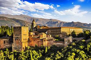
The Arabic Room was modeled on the Sala de Dos Hermanas of the Alhambra in Granada. Complimenting the beautiful architecture are lovely gardens. The grounds are filled with ancient plane trees, exotic plants, formal French-style landscaping, and statues of ancient Roman Emperors and gods.
About 47 kilometers south of Madrid, Aranjuez is easily accessible by train or car. The most memorable way to arrive is by taking the Strawberry Train (Tren de la Fresa). This restored 19th-century train features hostesses who dress in period costume and offer tastings of seasonal strawberries.
Departing from the Railway Museum in Madrid, the Strawberry Train runs on weekends in spring, summer, and autumn (through October). The scenic route travels past densely wooded forests and fertile farmlands.
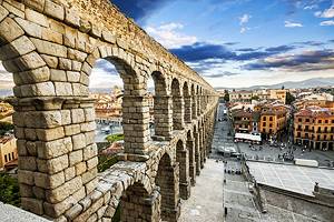
4. Segovia
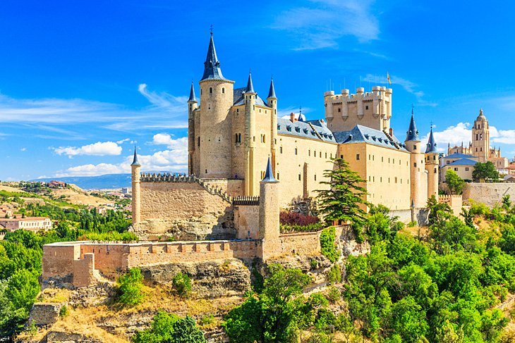
Like Toledo, Segovia stands atop a hill, commanding panoramic views of the surrounding Castilian countryside from its Alcazar.
Among the top attractions of Segovia is a rare treasure: the Ancient Aqueduct built in 50 CE, one of the two largest existing Roman structures in Spain. Not only do 167 of its original arches remain, but they are completely intact.
A discovery of history continues in the romantic, winding streets of Segovia's Old Town: the Judería with its synagogues that were turned into Christian Churches after the Reconquista, its Romanesque churches, encircling defensive walls, and metal workshops.
A stress-free way to get to Segovia from Madrid is on the Avila and Segovia Sightseeing Tour. This full-day tour includes round-trip transportation from Madrid and walking tours of both UNESCO-listed cities. A local guide provides commentary on the local history and culture. There is an option for a traditional gastronomic lunch in Segovia.
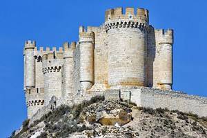
5. Sigüenza
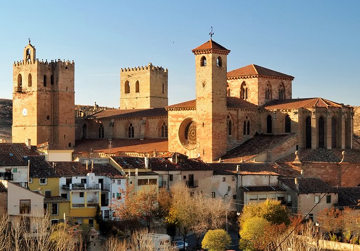
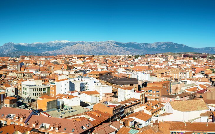
An ancient city in the province of Guadalajara (131 kilometers from Madrid), Sigüenza has an outstanding cultural heritage, which has earned it designation as a Historic-Artistic Site. The town was ruled by the ancient Romans and then the Moors during the 8th century, and was reconquered by Bishop Bernardo de Agen (who hailed from France) in 1124.
Dominating the town is the imposing Castillo de Sigüenza, a 12th-century castle with massive crenelated fortifications. This exceptional National Monument has been converted to the Parador de Sigüenza, a four-star hotel restored in keeping with its historical character. Original architectural features include the stone walls and a cobblestone courtyard. Guest rooms are outfitted with traditional Castilian décor, providing the feel of staying in a palace.
In an elegant dining room with forest views, the Parador de Sigüenza Restaurant serves cuisine of the Castile and La Mancha regions. The menu focuses on traditional local specialties such as migas (bread and meat stew seasoned with paprika) and bizcocho borracho (cake soaked in flavored syrup). The restaurant also hosts Opera Nights and Zarzuela performances.
For those who enjoy Relais & Châteaux accommodations, it is worth spending the night at the Molino de Alcuneza in the countryside outside of Sigüenza (about a 10-minute drive). This charming boutique hotel occupies a renovated 15th-century flour mill, set in a peaceful bucolic setting. Beautiful gardens beside a gurgling stream, an outdoor swimming pool, and an upscale spa add to the pampering experience.
An acclaimed chef at the Molino de Alcuneza's Michelin-starred restaurant prepares creative seasonal cuisine from locally sourced ingredients. Proud to be part of a new artisanal bread movement in Europe, the restaurant serves seven types of handcrafted organic bread, made using traditional flours milled from heirloom whole grains. The hotel actually utilizes its restored 500-year-old mill for this purpose, and the grains are grown by a local farmer.
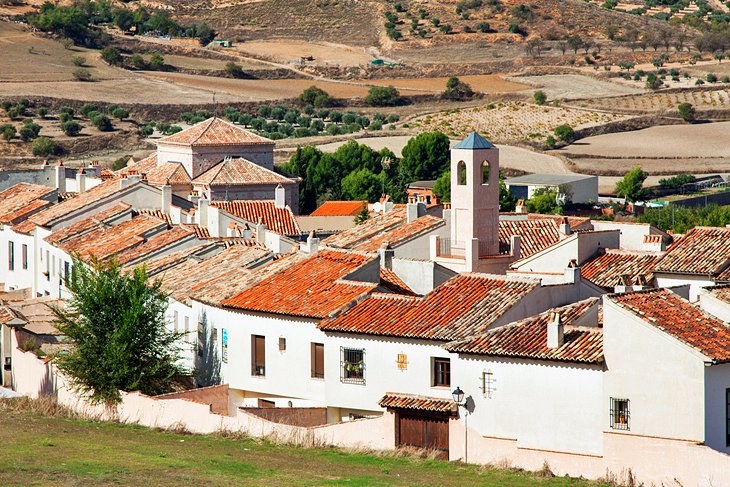
The atmospheric old streets of Sigüenza reveal a treasure trove of historic buildings. A must-see sight is the Plaza Mayor, a Renaissance-era market square lined with Casas de los Canónigos (lovely houses featuring decorative balconies).
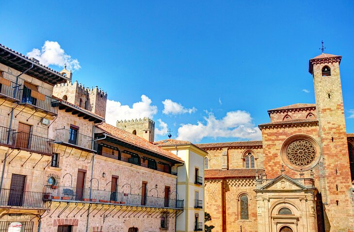
The fortress-like Catedral de Sigüenza was built after the Reconquest beginning in 1130. Originally Romanesque in style, the cathedral has a Gothic ribbed-vaulted nave with rose windows completed in the 16th century. The Capilla del Doncel (chapel) holds the tomb of Don Martín Vázquez de Arce, the young knight ("El Doncel") of Sigüenza, as well as an impressive sacristy.
The Capilla de la Anunciación is renowned for its Mudéjar design elements, while the Sacristía de las Cabezas features an intricately decorated Renaissance ceiling covered with innumerable medallions of faces and angels.
To delve deeper into the town's cultural heritage, visit the Diocesan Museum, which displays an exceptional collection of religious art housed in a Neoclassical palace. The collection spans the 12th to 20th centuries with an outstanding assortment of paintings, sculpture, altarpieces, textiles, manuscripts, and archaeological finds. Highlights include paintings by Spanish masters such as the Inmaculada by Zurbarán and the Assumption by El Greco.
One of the most interesting things to do as a day trip from Madrid is riding the Medieval Train from Madrid's Chamartín station to Sigüenza. This special train service includes entertainment of troubadour songs, a sampling of traditional regional cuisine, and informative commentary from "knights" about towns you'll see along the way. The train ride takes 80 minutes and runs on certain Saturdays in May, June, September, and October.
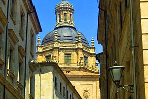
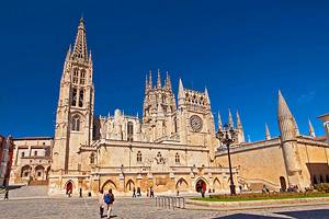
6. Alcalá de Henares: The Birthplace of Cervantes
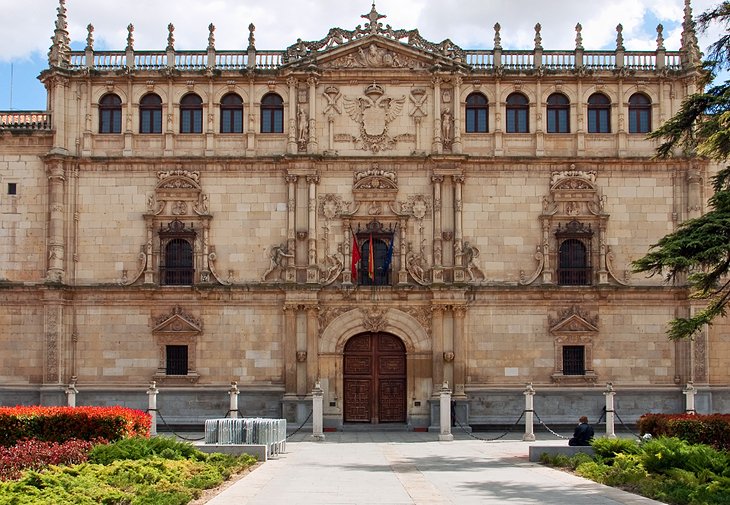
About 35 kilometers from the Madrid city center, the UNESCO-listed town of Alcalá de Henares has a prestigious pedigree as the birthplace of Cervantes, author of Don Quixote, and the Emperor Ferdinand I.
The town also boasts a famous university, the Universidad de Alcalá de Henares, founded by Cardinal Jiménez de Cisneros in 1498. The most impressive university building, the Colegio de San Ildefonso (Plaza de San Diego) epitomizes Spanish Renaissance architecture with its Plateresque façade created in 1543.
Not to be missed is the 16th-century Magisterial-Cathedral, one of two Magisterial churches in the world (the other is Saint Peter's in Louvain, Belgium). This Flamboyant Gothic monument was built on the site where child saints Justo and Pastor were martyred.
For general tourist information, head to the Visitor Center (Plaza de Cervantes) housed at the site of the parish church of Santa María la Mayor. Although the church has been demolished, the site is significant because Miguel de Cervantes was baptized at this location on October 9th, 1547. The visitor center displays a copy of Cervantes' certificate of baptism.
The main artery of the town and center of social life is the Calle Mayor. This bustling pedestrian street has arcades filled with many restaurants, cafés, pastry shops, and little boutiques.
The Cervantes Birthplace Museum, at 48 Calle Mayor, is a 20th-century reproduction of the 16th-century house where Cervantes was born. The house is furnished with period décor of the mid-16th to early-17th century (the era that Cervantes lived) and contains mementos of the author.
A short walk from the Cervantes Museum is the Parador de Alcalá de Henares. This luxurious four-star hotel occupies the former college of a 17th-century monastery, which has been renovated in modern minimalist style and updated with an upscale spa.
In its sleek dining room, the Restaurante Parador de Alcalá de Henares serves a blend of modern and classic Castilian cuisine. Specialities of the restaurant include migas alcalaínas (paprika-spiced sausage fritters), chickpea stew, croquettes, suckling pig, and piononos (sponge cake rolls topped with cream). On the anniversary of Cervantes' birth, the restaurant hosts a special event: Cervantes Culinary Days.
7. The Medieval Fortress of Manzanares el Real
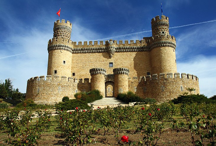
The historic village of Manzanares El Real is nestled in a picturesque valley of the Sierra de Guadarrama, a majestic mountain range that is protected as a national park. Manzanares El Real is an easy day trip from Madrid, just a 50-kilometer drive away.
Manzanares El Real is one of the best places to visit in Spain to admire a medieval fortress. The well-preserved Castillo de Manzanares El Real has a formidable look, with its crenelated defenses and imposing cylindrical towers. The monument exemplifies 15th-century Castilian military architecture. Massive ramparts with arrow slits were designed to fend off invaders.
The Castillo de Manzanares El Real displays 17th-century tapestries, as well as historic furnishings and paintings. This impressive landmark is also one of the most frequently used film sets in Europe. To immerse visitors in the monument's medieval ambience and history, the castle presents costumed theatrical performances.
Other noteworthy attractions in Manzanares El Real are the 13th-century Romanesque church, Iglesia de Santa María de la Nava; the Iglesia de Nuestra Señora de las Nieves, a 15th-century church with a Romanesque-style nave; and the Ethnological and Archaeological Museum in the Casa de la Cultura (Calle Cañada), which houses a rich collection of artifacts found in the region.
Set on a hilltop one kilometer outside the village, the Ermita de Nuestra Señora de la Peña Sacra is a 15th-century hermitage with splendid views of La Pedriza del Manzanares mountains. Nature lovers will want to explore the beautiful surroundings by taking one of the walking paths, either from the village to Santillana Reservoir or from the village to Peña Sacra Hermitage.
8. Colmenar Viejo
About 35 kilometers away from Madrid, the town of Colmenar Viejo is surrounded by cattle ranches in the rural area of the Sierra de Guadarrama.
Colmenar Viejo has two interesting cultural attractions. In a traditional 17th-century house, the Casa-Museo de la Villa presents a diverse assortment of museum collections including history, ethnography, and archaeology. The Centro Cultural Pablo Ruiz Picasso hosts interesting temporary exhibitions of modern art.
The town's religious and artistic heritage is best seen in the Basílica de la Asunción de Nuestra Señora, built between the 15th and 16th centuries. The richly decorated façade features intricate sculptural details, while the 50-meter-high tower is elaborately embellished with a carved stonework spire in the Castilian style.
Inside, visitors are awed by the spacious high-vaulted sanctuary and the gilded Plateresque high altar. The basilica houses a museum of sacred art.
To round out a tour of the town's religious monuments, tourists should also visit the lovely 17th-century Ermita de Nuestra Señora de los Remedios, a lovely and serene hermitage built on the site of an ancient shrine of the 7th century.
Every year at the end of January or in early February, the town hosts a traditional folk festival (La Vaquilla) that celebrates the cattle migration. Cows adorned with ribbons, paper flowers, rosettes, manila shawls, and jewels are paraded through town.
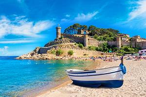
9. Chinchón
Just 20 kilometers northeast of Aranjuez is the little Castilian town of Chinchón, surrounded by olive orchards. The central focus of the town is the Plaza Mayor, which is enclosed by handsome historic houses with shaded balconies. The Plaza Mayor also has many small cafés, restaurants, and shops.
Chinchón is known for its summer program of cultural events including plays and concerts. The town has also hosted bullfights since the 16th century and still continues the tradition.
For the best view of the entire town, head to the Iglesia de Nuestra Señora de la Asunción. This splendid church displays the Assumption of the Virgin Mary painting, a masterpiece by Goya.
10. Palacio Real del Pardo
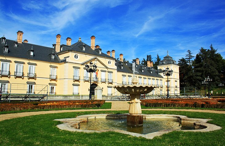
An easy day trip destination, the Palacio Real del Pardo is only 15 kilometers from the Madrid city center. This stately palace was built on the site of a royal hunting lodge, located here because the El Pardo hills were prized hunting grounds. In the 16th century, Charles V completely rebuilt the palace, and after a fire in 1604 it was restored by Phillip III.
Tourists may purchase admission tickets (Tuesday through Sunday) to visit the interior of the palace, which is decorated with precious tapestries, delicate frescoes, and noteworthy paintings. The palace displays masterpieces of art by Titian and Goya, among others.
Set in delightful grounds, the palace is a pleasant place to visit and relax. Neoclassical gardens are laid out on two terraces with ornamental pools and gushing fountains. Formal French-style landscaping, statues, and decorative urns add to the beauty. Many fruit trees, especially cherry trees, bloom during springtime.
Address: Calle de Manuel Alonso, 28048, Madrid
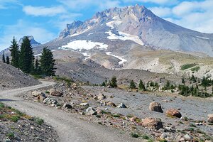
11. Puerto de Navacerrada Ski Resort
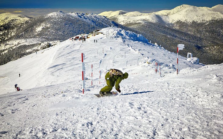
Puerto de Navacerrada is the closest ski resort to Madrid, 60 kilometers away (and 72 kilometers from Segovia). The Puerto de Navacerrada resort is found in the Sierra de Guadarrama mountains at an altitude of 1,858 meters.
The vast terrain of more than 10,000 kilometers is divided into two areas for different ability levels: The lower area has beginner to intermediate slopes, and the upper area has intermediate to advanced slopes. They are well-sheltered pistes, running between pine woods.
The resort has a ski school, ski equipment rentals, many restaurants, and plenty of hotel options. The picturesque village of Navacerrada is also worth exploring. The resort is easily accessible by car or train.
12. Guadalajara
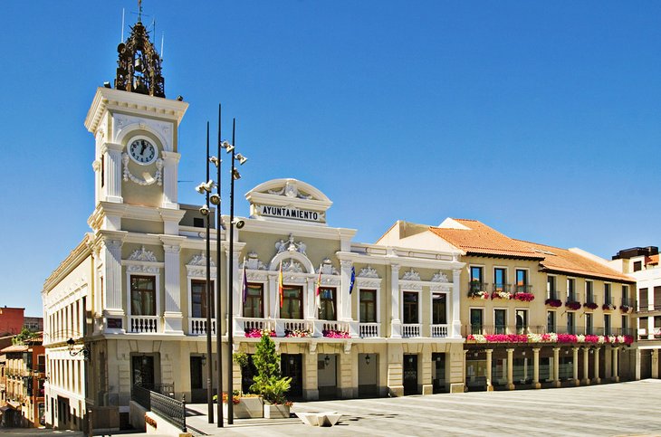
Standing proudly along the Henares River, the town of Guadalajara has a long illustrious history tied to the Dukes of El Infantado. A fascinating aristocratic legacy is seen in the town's superb monuments.
Tourists should be sure to visit the Palacio de los Duques del Infantado, the most emblematic landmark in Guadalajara. The palace was built in the 15th century in Gothic style with Mudéjar (Spanish Islamic-style) details. The 5th Duke of El Infantado renovated the palace in Renaissance fashion, with balconies on the façade, and commissioned splendid frescoes in several rooms.
The Museum of Guadalajara displays its collections of fine arts, archaeology, and ethnography in a section of the Palacio del Infantado that is adorned with 16th-century frescoes. The majority of the fine arts collection represents religious artworks.
Also a must-see sight, the Concatedral de Santa María de la Fuente was built in the 13th century on the site of an old Moorish mosque. The cathedral's façade features Renaissance renovations, and the interior was enhanced with a glorious 17th-century cupola.
Another important religious building is the Capilla de Luis de Lucena. This unusual little chapel blends Romanesque and Mudéjar architectural elements.