10 Top-Rated Attractions & Things to Do in Corinth
Ancient meets modern in Corinth (Korinthos), a town that is considered the gateway to the Peloponnese Peninsula. During Roman times, it was one of the largest and wealthiest city-states in Greece, with two major ports: one on the Corinthian Gulf and one on the Saronic Gulf.
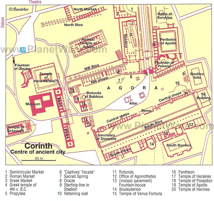
Today, the site where Ancient Corinth once stood has been excavated by archaeologists from the American School in Athens since 1896. The extensive remains are dominated by famous places to visit, like the ruins of the Temple of Apollo. Behind the site rises the hill of Acrocorinth (Akrokorinthos), which was fortified during the Middle Ages.
The modern town of Corinth lies seven kilometers northeast of the ancient city and only an hour's drive west of Athens, to which it is connected by a regular bus service. The town is also famous for the Corinth Canal, which gives ships a route through the isthmus of Corinth. There are many rewarding adventures in the Corinth area, including an adrenaline-rushing bungee jump. Plan your sightseeing with our list of the top attractions and things to do in Corinth.
- 1. Corinth Canal
- 2. Ancient Corinth
- 3. Temple of Apollo
- 4. Corinth Archaeological Museum
- 5. Acrocorinth
- 6. Loutraki
- 7. Environment Museum of Stymphalia
- 8. Zulu Bungy Jump
- 9. Modern Corinth
- 10. Saint Patapios Monastery
- Where to Stay for Sightseeing in Corinth
- Tips and Tours: How to Make the Most of Your Visit to Corinth
- Map of Attractions & Things to Do in Corinth
1. Corinth Canal
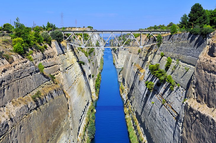
The idea of building a canal through the Isthmus of Corinth (which connects the Peloponnese to the rest of Greece) was conceived by the tyrant Periander in the sixth century BCE to link the Ionian and Aegean Seas. Its completion, however, didn't come about until the late 1800s after modern Greece gained independence.
Today, the Corinth Canal, which is four kilometers east of modern Corinth, is the city's top attraction. Creating it between 1882 and 1893 involved an excavation up to 80 meters in depth to create a canal that is 6.3 kilometers long, 23 meters wide, and eight meters deep and can accommodate vessels of up to 10,000 tons.
The best view of the canal is from the bridge, which carries the road over it. One of the most interesting features, however, is the submersible bridge at the north-west end. It can be sunk below the surface, allowing smaller ships and sailing boats to pass through after paying a hefty tariff. However, it is too narrow for larger ships.
2. Ancient Corinth
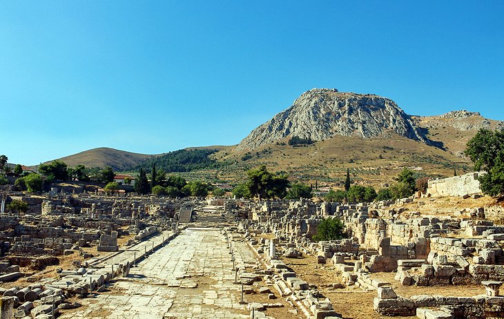
Ancient Corinth is an important archaeological site, which has revealed many great finds. Once one of the most powerful cities of the Classical world, it came under Roman rule in 146 BCE. It is here that St. Paul preached to the people of Corinth in 51-52 CE, and his experience later inspired him to write the New Testament books of the First Corinthians and Second Corinthians, among the most quoted books of the Bible.
Today, amid the archaeological excavations, you can see the ruins of various buildings including temples, a forum, baths, and a basilica.
3. Temple of Apollo
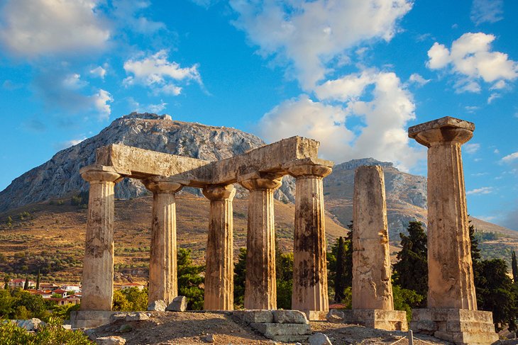
The most important monument in Ancient Corinth, the imposing Doric Temple of Apollo lies on a low hill and dominates the site. The temple was built around 540 BCE, on the site of an earlier seventh-century-BCE temple.
Today, only seven monolithic limestone columns remain, but originally there would have been six along the front and back of the temple, and fifteen down each side. In the first century CE, the Romans moved the main entrance into the temple to the west (formerly it had been on the east), and they built stoas (colonnaded walkways) to each side of the temple.
4. Corinth Archaeological Museum
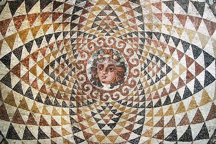
This small museum provides a comprehensive view of finds from the Ancient Corinth archaeological site. Built in 1931-32 and extended in the 1950s, the museum has three display rooms and a large courtyard. The main attractions are Neolithic finds, typical Corinthian pottery and ceramics, mosaic floors, and numerous headless marble statues (the ancients would simply remove the head of a deceased leader from a statue, and replace it with the new leader's head). Exhibits are labeled in both Greek and English.
The entrance ticket to the site is also valid for the museum.
5. Acrocorinth
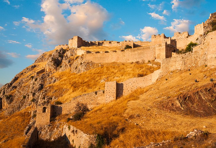
Acrocorinth (Akrokórinthos) lies 3.5 kilometers south of Ancient Corinth. The ascent to the top of this impressive fortified hilltop (575 meters) is made easier by a road, which climbs to a point near the lowest gate on the west side. Acrocorinth was fortified in ancient times, and its defenses were maintained and developed during the Byzantine, Frankish, Turkish, and Venetian periods, so that its walls now measure almost two kilometers in length.
Within the fortress, a path leads to the highest point, to the former Temple of Aphrodite, which was converted into a mosque by the Ottoman Turks in the 16th century. From here, there are fine views of the Isthmus and the hills of the Peloponnese.
6. Loutraki
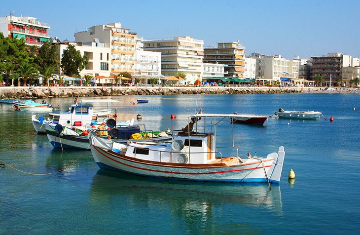
Overlooking the Gulf of Corinth, six kilometers northeast of Corinth, Loutráki is a popular seaside resort, which is wonderful to spend an afternoon wandering around, especially if you're in need of some heat therapy. Here, you'll find natural thermal springs at the Loutraki Spa, where you can spend some time soaking and sipping the healing water that is recommended for disorders of the urinary tract, kidney stones, gallstones, and gout.
The old town of Loutraki was destroyed by an earthquake in 1928, and today it consists mainly of concrete hotels erected during the second half of the 20th century.
7. Environment Museum of Stymphalia
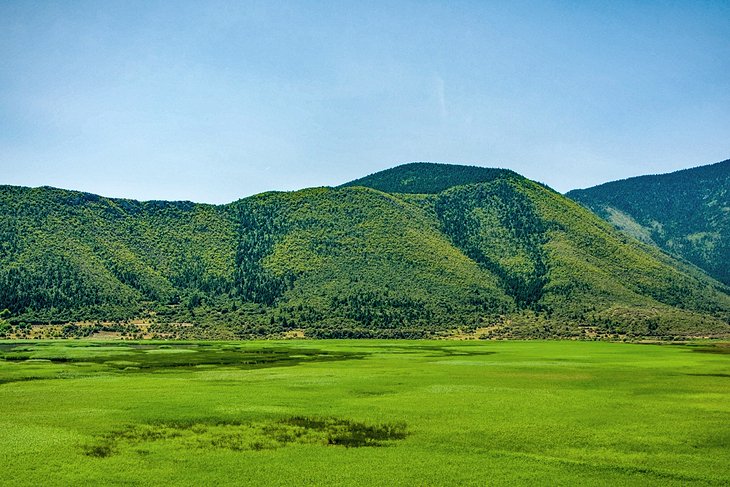
One of the most popular tourist attractions in Corinth is a museum dedicated to the region's eco-system, mainly Lake Stymphalia, where, according to mythology, Hercules confronted and defeated the Stymphalian birds with his arrow. The lake itself is a wonderfully relaxing place to visit and wander or run along the path around it.
The museum, back in town, has two permanent exhibits. The first addresses environmental concerns in the region, and the second explores the ways in which the environment has influenced development in the lake's basin.
8. Zulu Bungy Jump

When it comes to top things to do in Corinth, adrenaline junkies will definitely want to check out the Zulu Bungy Jump, founded in 2003 over the Corinth Canal. You'll jump from 70 meters high between the canal's two walls, which are 21 meters apart. It offers a totally different perspective of the canal (if you're not too freaked out after the plunge to focus on what you're seeing).
This is actually a great place to get over your fear of bungee jumping because the staff members are super warm and supportive and help you overcome your terror at taking the initial leap.
Official site: https://zulubungy.com/
9. Modern Corinth
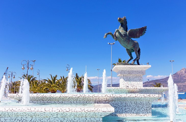
After a powerful earthquake took out Corinth's old town in 1858, it was rebuilt with a new look and locale on the coast overlooking the Gulf of Corinth, seven kilometers northeast of the ancient city. However, following another earthquake in 1928 and then a great fire in 1933, the new town went through even more building incarnations.
Today, modern Corinth consists mainly of contemporary concrete buildings, and everyday life centers on the cafés lining the square in front of the port. For tourists arriving from Athens and the rest of mainland Greece, Corinth is considered the gateway to the Peloponnese peninsula.
10. Saint Patapios Monastery
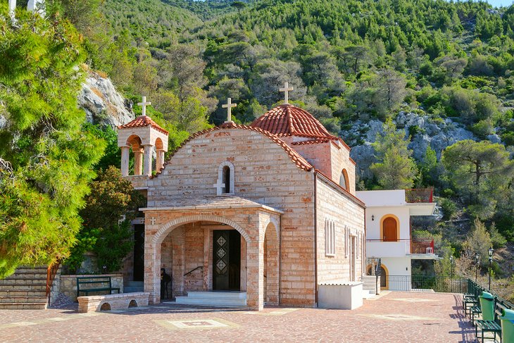
Located about 1,500 feet above the town of Loutraki on a steep mountain slope not far from Corinth, Saint Patapios Monastery is home to about 40 nuns, and it's open to visitors. To reach the monastery, you'll need to climb some 144 steps, but the views from the top are quite stunning. You can see the Corinth Canal, the gulfs of Corinth and Saronic, as well as Lake Vouliagmeni.
The complex of buildings here date back to the 12th century, when they were created as a hermitage. Today's monastery was founded in 1952 and is said to contain a number of holy relics pertaining to Saint Patapios, who was born in Egypt in the 4th-century.
Address: 203 00 Loutraki, Greece
Official site: https://www.monastiria.gr/holy-monastery-of-saint-patapios-loutraki-corinth
Where to Stay for Sightseeing in Corinth
When it comes to staying in Corinth, options are relatively limited. There are no luxury hotels in town; the highest ranked hotel is a three-star property. If you want true luxury, you can opt to stay in Athens and visit Corinth on a day trip. Here are our favorite hotels for sightseeing in the Corinth area. They are all located in and around the modern city.
Luxury & Mid-Range Hotels:
- One of the more luxurious properties is the three-star La Terra Nostra, which is located just outside the city center on orange-tree filled grounds, with views of the mountains and sea. The property offers accommodations in apartments and also has a lovely garden area with a swimming pool. It is not within walking distance of anything, however, so you'll need a car.
- For a more central location, try the Apollon Filoxenia Hotel, which offers simple but modern and clean accommodation within walking distance of the city's pedestrian area. It is also very good value. The property has a restaurant on-site and is also kid-friendly.
- Another option is the three-star Ephira Hotel, which is also in the city center, although it can feel a bit stale and dated. There is no on-site restaurant, but there are a number of places to eat within a short walk. Ask the front desk for recommendations. Car hire can also be arranged here.
Budget Hotels:
- For clean and tidy rooms that are excellent value try Pegasus Rooms, which is in a central location. The breakfasts here are excellent and served on the rooftop terrace with views. There is also secure parking for guests, and you can dine at the owner's restaurant on the main square just a few minutes' walk away.
- Even less expensive is the Acropolis Hotel, which offers clean but somewhat dated rooms. Breakfast is included in the rates. The hotel is centrally located for walkers. It also has a 24-hour front desk that is happy to assist with any questions or issues.
Tips and Tours: How to Make the Most of Your Visit to Corinth
- Day Trip to Corinth from Athens: At just an hour's drive from Athens, it is easy to visit Corinth on a half-day tour from Athens. This morning tour includes 90 minutes exploring ancient Corinth's ruins with an English-speaking guide, a scenic drive along the coast to the Corinth Canal, and a visit to the Museum of Ancient Corinth, among other activities.
Map of Attractions & Things to Do in Corinth
More Related Articles on PlanetWare.com
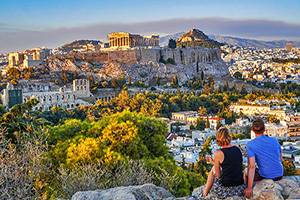
Athens: The Greek capital city is likely where you will begin or end your trip and is obviously a must-see for visitors. See our article on the Top-Rated Attractions & Things to Do in Athens.
Greek Islands: The Greek Islands are legendary vacation spots and offer a completely different experience than exploring history laden spots like Athens. One of the most popular Greek Islands is Santorini. For more on this stunning destination, see our article on the Top-Rated Tourist Attractions on Santorini. Kefalonia is another beautiful island in the Ionian Sea. Learn more with our article on the Top-Rated Attractions on Kefalonia.