10 Of Bali, Indonesia's Major Tourist Attractions To Add To Your Itinerary

A bucket list destination for many, Bali, Indonesia, is a total island paradise and one of the world's most beautiful destinations. After my recent trip to this stunning Indonesian island, I realized it's much more than a place to check off a list: It's a destination that gets under your skin and finds a way into your soul. Known as the "Island of the Gods," Balinese culture oozes a combination of spirituality, nature, and art that is unlike anywhere else. From high tide at Uluwatu to the calm of jungle waterfalls, Bali is a fully sensory experience that requires you to engage fully. For centuries, the island has drawn travelers seeking something deeper than sand and surf.
Whether it's the scent of frangipani drifting through temple courtyards, the sight of locals placing daily canang sari offerings, or the delicious food at every restaurant, Bali is a travel destination that will beckon you back before you even leave. Plus, with a long list of essential travel hacks to help you enjoy your Bali vacation, there are plenty of ways to make any trip even more unforgettable.
Combining personal insights from my own recent five-day stay in beautiful Bali along with official tourism resources and expert guides about iconic attractions you can't miss, this guide delivers the ultimate Bali traveler's roadmap. Because wether you come for the beaches, the spirituality, or the unique culture, you can rest assured Bali has a way of meeting you exactly where you are in your life.
Tegallalang Rice Terraces and Alas Harum
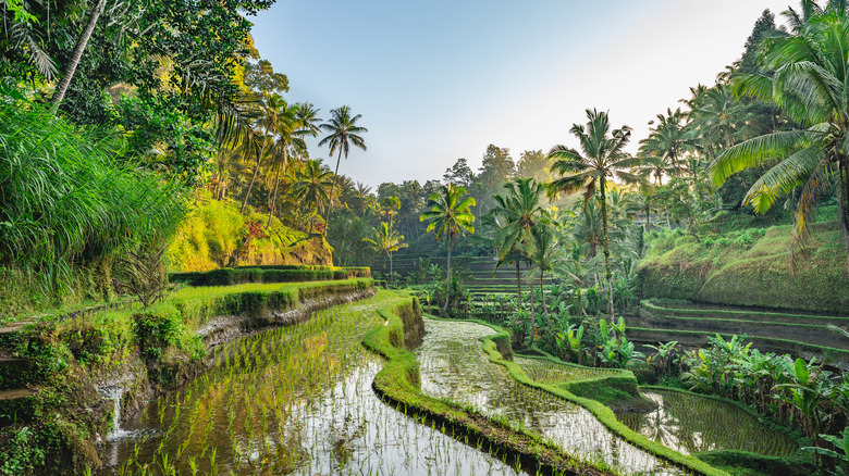
Alas Harum in Tegallalang, Ubud, offers enough activities to be a full-day experience for visitors. The Tegallalang rice terraces are among Bali's most breathtaking and photographed destinations — and it's easy to see why as soon as you set foot in the Alas Harum complex, where they take center stage. Layered in mesmerizing fashion, these UNESCO-recognized terraces showcase the ancient subak irrigation system that has sustained Balinese farming for over a thousand years. That said, it's important to remember that the terraces are more than just a pretty scenery. They are also their own living ecosystem, promoting a deep connection between the rice caretakers and nature itself.
Visitors to Alas Harum can wander through the terraces themselves, following narrow pathways (with plenty of photo ops!) that wind between the lush green paddies. A swinging bridge and soothing walkways connect various lookout areas, each offering a new vantage point of Ubud's beauty.
For those looking for a little more adventure, Alas Harum also has several rides and attractions. There, a zip-line, a suspended bicycle built for two, and the signature Bali Swings await. I personally rode the Angel Swing, which sent me soaring nearly 100 feet above the valley with absolutely epic views below. After exploring, make sure to grab a bite to eat and a drink at either Cretya Ubud or Cretya Lite, two of Alas Harum's on-site restaurants.
UC Silver Gold Complex and Naga Museum
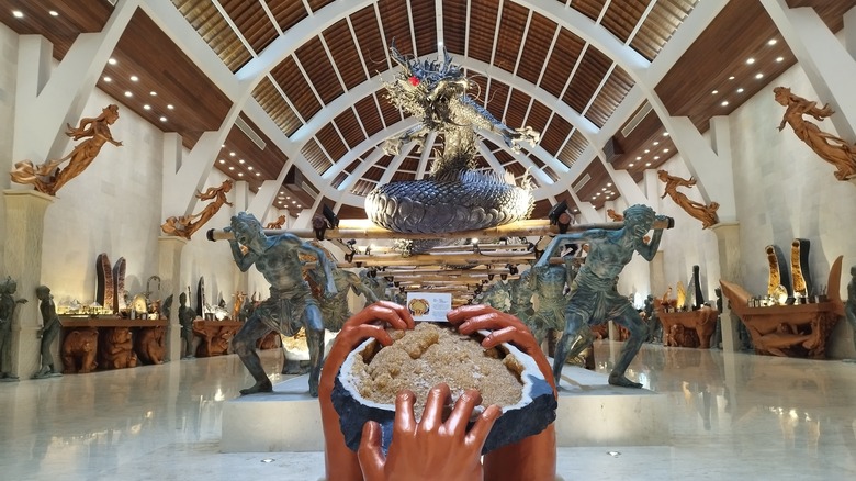
Bali's UC Silver Gold jewelry complex offers visitors a fascinating blend of artistry, culture, and craftsmanship. While it's best known as one of the island's premier jewelry houses, this destination is also home to a wonderful museum, the Naga Museum ("Dragon Museum"), which is dedicated to Balinese heritage.
At an elegant complex in Denpasar, UC Silver Gold creates intricate silver and gold creations inspired by Tri Hita Karana, the Balinese philosophy of harmony between people, nature, and the divine. Visitors can walk through the area where artisans make jewelry using traditional Balinese metalwork techniques, as well as enjoy ornate sculptures throughout the complex. Prices are reasonable, and the quality of the work is exceptional. I personally picked up an incredible six-carat freshwater pearl and diamond ring for much less than I would have paid stateside.
The Naga Museum, however, was the true highlight of the UC complex for me. Exhibits range from a massive raw citrine being "held" by wooden hands to a silver model of a traditional Balinese home, and traditional Indonesian ceremonial bracelets and diadems. The main attraction, though, is Indonesia's heaviest statue: Naga Sanga Amurwabhumi. This dragon statue (pictured above) was crafted using around 1,590 pounds of pure 925 sterling silver, and took 25 skilled Balinese artisans five years to complete. For travelers seeking a unique cultural experience off the typical tourist trail, the UC complex and Naga Museum is a great place to visit. Plus, you can even purchase a gorgeous souvenir while you're there!
Tegenungan Waterfall
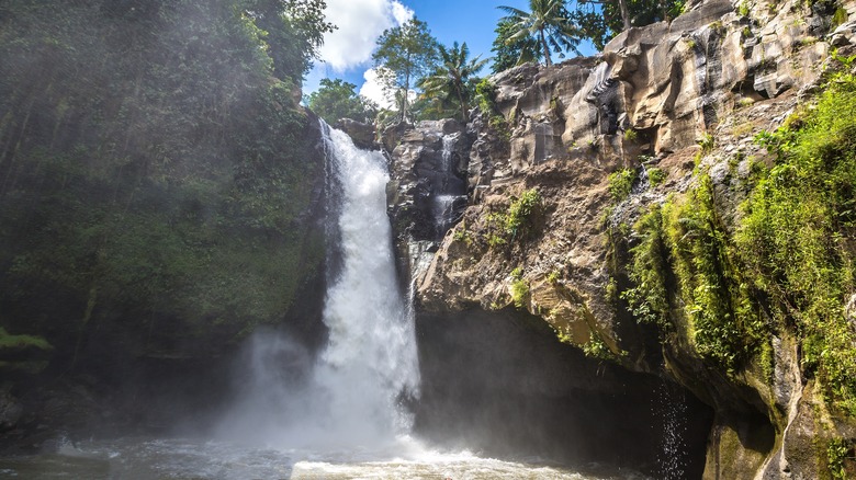
Approximately a 30-minute drive from central Ubud, Tegenungan Waterfall is one of Bali's most accessible natural wonders. While many of Bali's waterfalls require travelers to trek through dense jungle foliage, Tegenungan has a properly-maintained path and stairs that lead directly to its base. This makes it a great choice for families with children and casual hikers.
At the bottom of the staircase, visitors can enjoy a dip in the natural pool or take in the view from a distance without getting wet. It's worth noting that this is the jungle of Indonesia, so water quality is not guaranteed. That said, surrounded by beautiful scenery, Tegenungan offers the perfect backdrop for photos. The waterfall's steady, year-round flow also makes it a favorite among tourists, since some of Bali's waterfalls slow to a trickle during the dry season.
Early morning is the best time to visit, when crowds are low and the light is still soft before the heat of the day. If you want to turn your visit to Tegenungan Waterfall into a day trip, that's also easy to do, as there are various tourist-centric shops and restaurants close by. Specifically, Bumbu Asli offers an exotic view overlooking the waterfall, while Omma Day Club invites guests to spend an entire afternoon soaking up the sun with Tegenungan in the background. While you're there, you might also want to check out more of Ubud, Bali's most artsy jungle neighborhood. Ultimately, whether you're chasing waterfalls all over Bali or simply looking for an easy hike for your entire family, Tegenungan is a great spot.
Tukad Cepung Waterfall
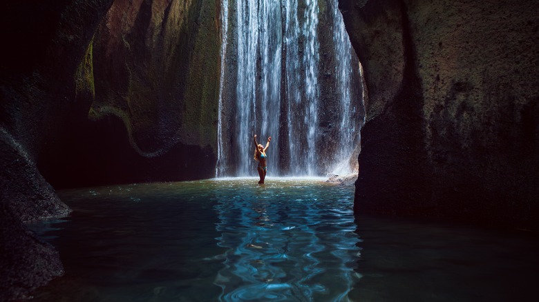
There are waterfalls, and then there's Tukad Cepung. Situated deep within a cave near the village of Tembuku, about an hour and a half from Ubud, this spot feels like stepping into another world. Shafts of light come through the narrow opening above the fall, bouncing off the stones and water, making visitors feel as if they've stepped into a dream.
Getting there, however, is half the adventure. The journey begins with a steep descent down stone steps, continues through a riverbed — I am 5'9" and the water was up to my knees in spots during our hike — before the cavern reveals itself. It's a trek that calls for waterproof shoes, good balance, and a some grit — but the end experience is well worth the slippery climb.
When you finally reach the falls, you'll hear the water before you see it. The roar of the rushing water is unmistakable, and the play of the light within the Tukad Cepung cavern shifts constantly. While we were there, I saw it create a tiny rainbow in the mist. This spot has global appeal, and everyone comes together during the hike to the falls, which means we met travelers from Germany, the United Kingdom, and Australia as we slogged toward the falls. Similarly to Tegenungan, there are spots to rest on your hike back to the top. We stopped at The Cepung Restaurant — I highly recommend the strawberry banana smoothie — and took in the jungle view for a while before ending our time in this stunning location.
Uluwatu Temple
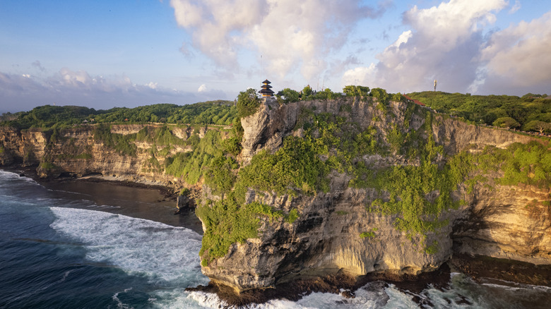
At 230 feet above the Indian Ocean on the edge of a limestone cliff, Uluwatu Temple (Pura Luhur Uluwatu) is one of Bali's most breathtaking and spiritually significant sites. Although the existence of a temple at this location dates back as early as the ninth century, the current structure is often attributed to Mpu Kuturan, an influential Hindu sage from the 11th century.
The temple itself is relatively unassuming, but the setting takes it to the next level with panoramic views of the water and golden-tinted sunsets. Beyond that, the long-tailed macaques that protect this temple are considered sacred to Hindu people, and their conservation is a major goal at both Uluwatu Temple and nearby Labuan Sait Beach.
At dusk, the atmosphere at Uluwatu Temple shifts as performers and spectators prepare for the traditional Balinese Kecak fire dance. Through chants, rhythmic movements, and flames, performers tell the story of the Ramayana, a Hindu epic poem. There are two separate hour-long shows nightly — one at 6 p.m. and another at 7 p.m. — and it is highly recommended that visitors book tickets in advance. As with all Balinese temples, modest dress and respectful behavior are required, and sarongs are provided upon entry. An excellent alternative to other Bali destinations that are sometimes considered tourist traps, Uluwatu perfectly captures the spirit of Bali.
Pandawa Beach
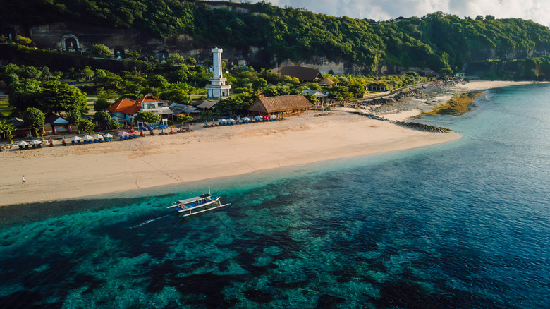
As one of the most beautiful islands in the world, Bali has no shortage of gorgeous beaches. Among them is South Kuta's Pandawa Beach. Once known only to locals, this stretch of sand along the Indian Ocean became accessible after a now-famous road was sliced through the region's limestone cliffs. As you near the beach upon arrival, you're greeted by oversized statues of the five Pandawa brothers from the Hindu epic tale, Mahabharata.
The water here is calm and clear, which makes it ideal for swimming or snorkeling. During our visit, we also found the crowd levels minimal, so we were able to genuinely unwind. There are also plenty of local bars and restaurants dotting the beach, many of which have comfortable seating under thatched roofs or offer umbrella rentals.
My personal recommendation at Pandawa Beach is Roosterfish Beach Club. We spent an entire afternoon at this chic oceanfront spot, which offers great food, delicious cocktails, and affordable daybeds right by the pool overlooking the beach. If you're looking for a more adventurous day, however, you can also go paragliding. Whether you come to swim, sunbathe, or soar through the sky, Pandawa Beach is at once luxurious and unpretentious. It's the kind of place that makes you want to stay just one more hour, every hour.
Ubud Monkey Forest

Deep within Ubud lies one of Bali's most notable destinations: the Sacred Monkey Forest Sanctuary. More than just a tourist attraction, this jungle reserve is a protected space that is home to more than 1,200 long-tailed macaques and three ancient Hindu temples. The main temple, Pura Dalem Agung Padangtegal, is believed to be one of the oldest in the region, dating to around 1350 AD. While the monkeys are entertaining by nature, macaques are considered guardians of the temple complex, and are thought to protect it from harm. As a result, visitors are expected to respect the animals and the sanctity of the space by maintaining a calm demeanor and avoiding direct feeding or contact with them.
In addition to the monkeys themselves, the Sacred Monkey Forest Sanctuary also offers Balinese cultural experiences for both locals and tourists. On weekends, there are two daily performances of the Lubdhaka Dance. This dance narrative, in which good ultimately triumphs over evil, revolves around Lubdaka, a fisherman who is faced with difficult circumstances. Meanwhile, on Sundays, travelers can also enjoy two abbreviated performances of Tari Katak ("The Balinese Frog Dance"), which takes inspiration from how frogs act via the dancers' facial expressions and the overall choreography. A visit to the Sacred Monkey Forest will undoubtedly stay with you long after you leave.
Tanah Lot Temple

If you've looked up photos of Bali while planning your dream trip to the world's largest island country, chances are you've probably seen Tanah Lot. Considered one of Bali's most Instagram-worthy sites, Tanah Lot's main claim to fame is that it appears to float on the ocean when high tide rolls in — an optical illusion that makes the destination visually stunning. However, this does mean that, if you find yourself exploring the temple at high tide, you'll have to wait again for low tide to access to the path to leave.
One of the most interesting facts about this ancient temple is that it's believed to be protected by poisonous sea snakes that live in its general vicinity. According to legend, the temple's founder, Dang Hyang Nirartha, ensured the snakes' existence to protect Tanah Lot from evil.
It is important to note that, unless you are a Hindu worshipper, you will not be granted access to the inner sanctum of this temple. That said, you can still enjoy the beauty of the scenery and the temple's exterior. For the best possible experience, it's recommended that you time your visit a couple of hours before sunset. This also allows you to avoid the midday heat, which can be intense this close to the equator.
Mount Batur

If you're looking for an adventure on your Bali holiday, climbing Mount Batur at sunrise is something of a rite of passage. Trekkers generally start their ascent very early — or late, depending on your view of the clock — at around 2:00 a.m. to see the beautiful colors from the top of the mountain as the sun comes up. Be warned, though: While the first half of the hike (about 50 minutes) only involves a slight incline, the second half of the trek is much more challenging. Nonetheless, you should still be able to reach the top in around 90 minutes. Considered by locals as the second-holiest Balinese mountain after Mount Agung, the last time this active volcano erupted was in 2000.
A few key tips for those considering the Mount Batur sunrise trek include packing a flashlight, dressing in layers so you can remove some pieces as you start sweating, and staying away from the monkeys at the top of the mountain, as they are prone to stealing food. For those who want to see the famous Mount Batur sunrise without overly exerting themselves, there are also Jeep tours available. Starting from roughly $20, the most basic package includes pick-up and drop-off, transportation, admission fees, bottled water, and a light breakfast. The trips are all accompanied by an English-speaking guide who can fill you in on everything there is to know.
Garuda Wisnu Kencana
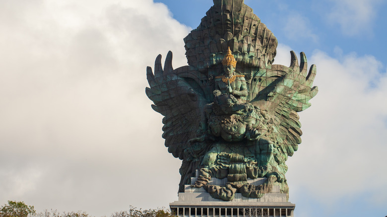
Standing 397 feet tall, Garuda Wisnu Kencana (GWK) is currently recognized as the largest statue in Indonesia. To put it in perspective, the Statue of Liberty is nearly 100 feet shorter, standing at 305 feet. Visible from nearly every part of Bali, GWK is a carving of the Hindu god Vishnu riding his avian companion, Garuda. Located within the Garuda Wisnu Kencana Cultural Park, there are several ways to visit the statue.
You can view it, of course, from a distance, or you can visit the park to look at the giant bird with Vishnu atop it from the outside. To get a literal insider perspective, though, you'll need to book the "Top of the Statue Tour." With stops at the ninth and the 23rd floors, visitors can enjoy something different on each level. While the ninth floor houses a museum where visitors can learn more about how the GWK statue was crafted, the 23rd floor is where travelers can soak in panoramic views of Bali. Although the statue is the main draw to Garuda Wisnu Kencana Cultural Park, the space also hosts a variety of other events and performances — including the Kecak Garuda Wisnu dance, Balinese musical performances, and the first-ever Barong show in South Bali.
For visitors arriving at Gusti Ngurah Rai International Airport (DPS), the first glimpse of GWK as you land on the runway feels like a mythical welcome from the Island of the Gods. Then, as you leave, your last look of Garuda Wisnu Kencana is the perfect way to say goodbye to a place that will undoubtedly stay with you forever.
Methodology
In order to land on our picks for the 10 best tourist attractions in Bali, I combined personal experiences from my own recent trip with traveler consensus from sources like TripAdvisor, as well as official location and tourism websites. The main goal was to curate a comprehensive list of attractions that balance natural beauty, cultural immersion, and accessibility for travelers.
Along with practical details like location and costs, I also included insider tips from the attractions I personally experienced, as well as research insights for any of those I didn't have a chance to do or see during this particular holiday.