14 Top-Rated Day Trips from Zürich
Zürich's location in north-central Switzerland, plus the country's excellent rail network, makes it a good base for day trips. In an easy day from Zürich, you can sample Switzerland's magnificent Alpine scenery, ride trains to mountaintops, visit postcard villages, travel to the tiny principality of Liechtenstein, delve into history, take lake cruises, and admire impressive waterfalls.
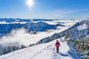
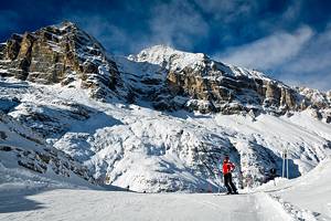
If you are traveling in the winter, along with sightseeing, you can even spend a day at one of Switzerland's best ski resorts, in the Bernese Oberland.
You can also explore the many things to do in lovely Lucerne and cruise its lake in an authentic paddlewheel steamboat, or stroll the streets of the Swiss capital of Bern. Travel by train is easy in Switzerland, or you can sign up for one of the many day tours that explore the tourist attractions around Zürich.
Whether you're taking a break from business in Zurich or visiting Switzerland with your family, you'll find plenty of places to visit with our list of the best day trips from Zurich.
- 1. Jungfraujoch and the Bernese Oberland
- 2. Lucerne
- 3. Mount Titlis
- 4. Rheinfall (Rhine Falls)
- 5. Eastern Swiss Alps and Liechtenstein
- 6. Bern
- 7. Stein am Rhein
- 8. Schaffhausen
- 9. Winterthur
- 10. Mount Pilatus
- 11. St. Gallen
- 12. The Spa Town of Baden
- 13. Glarus
- 14. Regensberg
- Map of Day Trips from Zürich
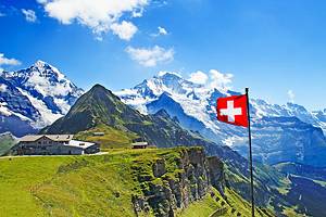
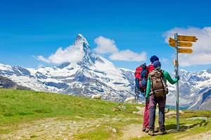
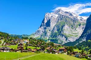
1. Jungfraujoch and the Bernese Oberland
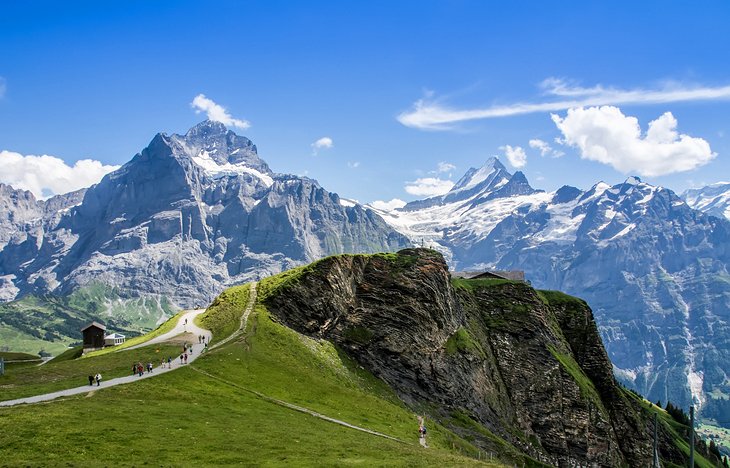
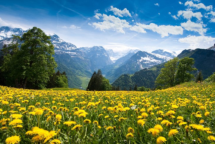
The three famous peaks of the Jungfrau massif — the Jungfrau, the Mönch, and the Eiger — are in the heart of one of Switzerland's most beautiful regions, the Bernese Oberland. Along with the snowcapped mountains, long-time favorites of skiers and climbers, the region's steep green pastures and idyllic little Alpine villages like Wengen and beautiful Lauterbrunnen, set beneath long, ribbon-like waterfalls, have made it a popular place to visit for more than a century.
The largest town is Interlaken, named for its scenic setting between Lake Thun and Lake Brienz. In Grindelwald, you can board a cog railway that climbs to the Jungfraujoch mountain pass, listed as a UNESCO World Heritage Site for its remarkable scenery.
At the highest railroad station in Europe, at 3,454 meters, the Jungfraujoch has a hotel, restaurants, research stations, and an Ice Palace carved into the glacier. Ride the elevator to a viewing platform at the summit of the Sphinx for views of the Aletsch glacier and Alps. The trip up the Jungfraujoch is one of the best things to do in Switzerland.
The 11-hour Top of Europe Day Trip from Zurich can take you through this spectacular region by coach and includes the cog railway to the Jungfraujoch and a trip through the Ice Palace inside the glacier and to the viewing platform at the summit of the Sphinx.
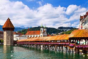
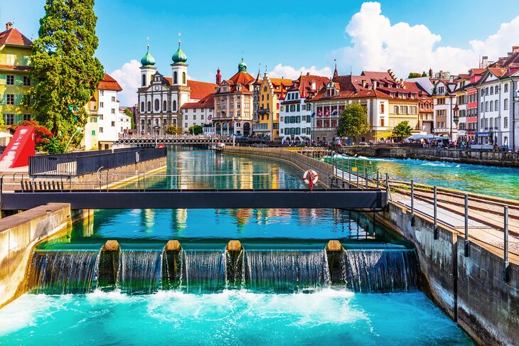
2. Lucerne
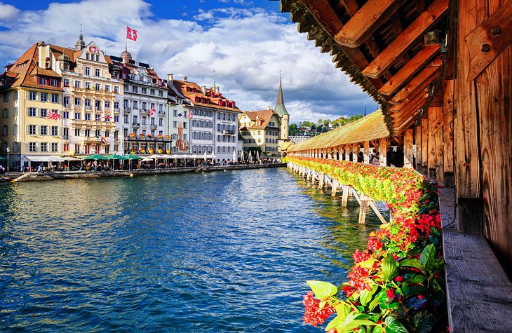
Spread along the banks of the River Reuss as it flows out of Lake Lucerne, Lucerne was an important medieval trading town and retains many of its old features in its compact center. Most tourists head first to Lucerne's most popular landmark, the Kapellbrücke, a covered wooden bridge built in 1333.
Inside are more than 100 pictures of saints and scenes from the town's history. The octagonal Wasserturm beside it is a 13th-century water tower from the town's fortifications. Paintings inside the second covered wooden bridge, the 1406 Spreuerbrücke, depict the Dance of Death.
Take time to explore the Altstadt, the old town on the right bank of the Reuss, to admire the brightly painted old burghers' houses, timber-framed buildings, and little squares with fountains. Look especially for the Kornmarkt with the Altes Rathaus, built in 1602-06, and the adjoining 14th-century tower.
The picturesque Weinmarkt has an elaborate Gothic fountain. The 9.5-hour Lucerne City Tour can take you from central Zurich over the scenic Albis Pass to the heart of Lucerne for a guided sightseeing tour. After visiting landmarks like the Kapellbrücke and the Lion Monument with your guide and learning about Lucerne's history, you'll have plenty of time to explore on your own, returning to museums, or even to take a cruise on one of the lake excursion boats.
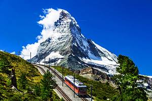
3. Mount Titlis
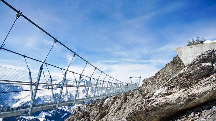
It's not just spectacular 360-degree Alpine views that await you at the 3,238-meter summit of Mount Titlis. Atop this lofty crest are several ways to explore the glacier and the Alpine environment.
The trip from Zürich takes you past Lucerne and along its scenic lake shore to Engelberg in the Swiss Alps. There, you begin your ascent of Mount Titlis, arriving at the summit via a revolving cable car that reveals the changing scenery in all directions as you climb. At the top are the fascinating ice boulders and deep crevasses, which you can see up close from the Ice Flyer chairlift. A trip down the Glacier Park snow slide turns this frozen world into a giant natural playground.
For more thrills and views, walk across Europe's highest suspension bridge. Or just soak up the scenery from a café on the mountaintop sunny terrace. The Mount Titlis Day Tour from Zurich combines the scenic vistas of the mountaintop with a guided tour of the highlights of Lucerne. In the winter, the 9.5-hour excursion includes time to slide downhill on snow tubes or even ski on the beginner slopes, with equipment provided.
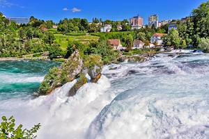
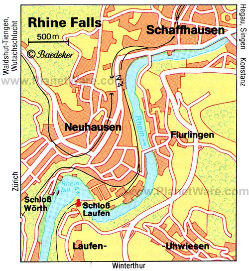
4. Rheinfall (Rhine Falls)
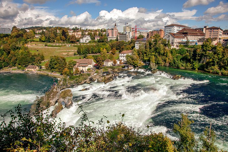
After emerging from the west end of Lake Constance, the Rhine River flows through a beautiful green valley, then plunges over the Rhine Falls before flowing on toward Basel. The mightiest falls in Central Europe surge over a ledge of Jurassic limestone 150 meters across and up to 21 meters high, with two higher rocks standing in the middle of the river. The flow of water is at its greatest in June and July, after the mountain snows melt.
The falls are easily visible from both sides, and you can see them from below on a 30-minute boat tour through the churning waters. Another fine vantage point, especially at night when the falls are floodlit, is from the Schlössli Wörth, set on a tiny island that from the 13th to the 19th centuries was an important shipping and reloading area for goods on the trading route from Lake Constance to Basel. Today, it is a fine-dining restaurant and café with a terrace overlooking the falls.
The half-day Rhine Falls Tour from Zurich takes you there, on a climate-controlled coach ride past castles and through the beautiful town of Schaffhausen. This is a good tour if your flight arrives in Zurich before your hotel is ready, or even if you are just passing through the city, as there is the option of an airport pickup and drop-off.
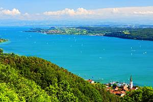
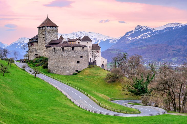
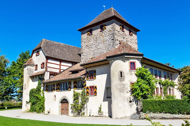
5. Eastern Swiss Alps and Liechtenstein
East of Zurich is a beautiful land of lakes and green valleys that quickly soar to Alpine peaks. Known to children everywhere as the homeland of Heidi, the region is dotted with charming mountain villages in magnificent Alpine settings. One of these, Maienfeld, is the setting for the children's classic Heidi, and one of its rustic homes has been furnished as described in the book. Heidi House is open to visitors in the summer and is a favorite photo-op all year.
Between this "Heidiland" and the Austrian Alps is the tiny principality of Liechtenstein, with its hilltop Royal Castle and famous postage stamps. Its capital, Vaduz, is the smallest in Europe, a picturesque town on the banks of the Rhine River. Liechtenstein has five castles, two of which - the royal residence of Schloss Vaduz and Burg Gutenberg in the village of Balzers - are intact, and the other three are romantic ruins.
You can tour this region with the Heidiland and Liechtenstein Tour from Zurich: Two Countries in One Day, with a guide who can point out landmarks and fill in the history and culture as you travel by coach through the stunning scenery. The trip begins with a city tour of Zurich before traveling along the shores of Lake Zurich to Rapperswil, with its medieval castle.
A stop in the village of Maienfeld allows plenty of time to visit the Heidi House if it's open, and there is time to explore Liechtenstein's capital of Vaduz.
6. Bern
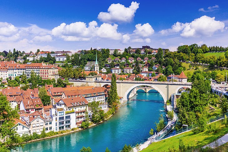
The capital of Switzerland is only 125 kilometers southwest of Zurich and easy to reach by direct train. Bern's Old Town has been named a UNESCO World Heritage Site for its streets of 17th- and 18th-century houses and shops, characterized by steep roofs and street-front arcades.
The Old Town of Bern is even more picturesque because of its dramatic setting atop a high ridge that is almost completely encircled by the River Aare. The Old Town is where you'll find many of the main attractions, which include its famous clock tower with moving figures and the splendid Munster. But Bern's main draw for tourists is the old city itself, with its charming, stone-paved streets and lanes, its beautiful fountains, steep roofs, and towers.
You can combine a tour of Bern with visits to sample two of Switzerland's most famous products, Emmental cheese and Kambly Swiss biscuits, on a 10.5-hour Bern Day Trip from Zurich. With a guide to point out landmarks as you drive through the Entlebuch Valley and Upper Emmental Valley and bring them to life with a little history, you'll tour Bern's old Town and stop between Bern and Zurich to watch demonstrations of biscuit and cheese-making, with samples of each to taste.
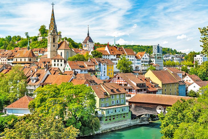
7. Stein am Rhein
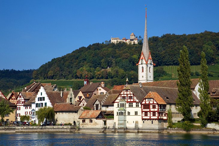
Arriving in Stein am Rhein, about an hour from Zürich by train, you feel as though you've been dropped abruptly into medieval Switzerland. Except that the timbered buildings that line its main street are in far better condition than they probably were in the Middle Ages. Colorful frescoes, also beautifully maintained, decorate the buildings around Rathausplatz, the cozy main square. Flowers hang from window boxes, making every angle photo-worthy.
One of the most charming towns in Europe, Stein am Rhein began as a Roman fortress beside the Rhine, built in the third century to secure the river. Learn more about the town's long history at the museum inside Hohenklingen Castle, built above the town in 1225.
Views from the castle encompass the compact town and the river valley. Visit the well-preserved Medieval Monastery of St. Georgen, browse among the works of local artisans in the excellent gallery, or just linger in a Rathausplatz café to savor Stein am Rhein's Medieval atmosphere.
8. Schaffhausen
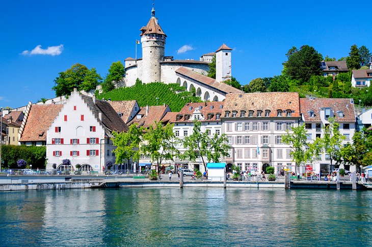
The old town of Schaffhausen, about 50 kilometers from Zürich, is a postcard-perfect scene of colorfully painted timber-frame houses with oriel windows and coats of arms on the facades. On Fronwagplatz are the Fronwag tower and two fountains from the 1500s, while the single-towered Münster, built from 1087 to 1150, was originally the church of a Benedictine abbey. Be sure to see the delicate 12th-century arcades in the cloister.
The handsome convent buildings now house All Saints Museum, one of the richest local museums in Switzerland, with collections of prehistoric material, religious art, period rooms, traditional costumes, and works by modern Swiss artists. Its two chapels from the 11th century and a Romanesque loggia are good places to visit as well.
Overlooking the old town and river from a vine-clad hill is 16th-century Kastell Munot, a circular castle fortified with walls more than five meters thick. Not only is the well-preserved castle interesting, it provides fine views of the town and the Rhine valley.
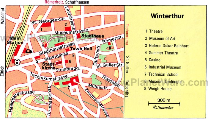
9. Winterthur
Winterthur, about 26 kilometers from Zürich, can thank the thriving craft industry of its past for today's art and cultural largesse. The little triangular Old Town still preserves streets with rows of old burghers' houses - look especially for the Waaghaus in Moorish-Gothic style, Zur Geduld with an Early Baroque façade, the elegantly Rococo Hans zum Adler at the Obertor, and the graffiti on the Hans zum Hinteren Waldhorn.
For its size, Winterthur is well endowed with museums: applied and decorative art in the industrial museum, a natural history museum, a clock collection, and three separate art museums. One of these, the Oskar Reinhart Collection includes works by Rubens, Rembrandt, El Greco, Goya, Renoir, and Cézanne.
At the excellent Technorama of Switzerland, you can learn about science and technology in compelling exhibits filled with hands-on activities that make it a favorite place to go for families.
10. Mount Pilatus
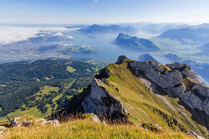
The trip up Mt. Pilatus gives you a taste of the various feats of Swiss engineering as well as a chance to sample both the cable cars and the mountain cog railways that make so many mountain towns and mountaintop views accessible.
The trip from Zürich passes through Lucerne before arriving at Kriens, where you board a panoramic gondola then an aerial cable car to just below the 2,132-meter summit of Mount Pilatus. From the terrace are panoramic views of central Switzerland and the Alps. Short trails lead to the various peaks of this rugged limestone massif, for even broader views.
For a full sampling of Swiss mountain transport, make your return trip down Mount Pilatus by cogwheel railway, traveling at a gradient of 48 percent, one of the world's steepest for a railway. The cog railway brings you to Alpnachstad, from where you can return to Lucerne by boat on a scenic cruise across Lake Lucerne before returning to Zürich.
You can book this entire trip in one package by taking the Mount Pilatus Summer Day Trip from Zurich. This 9.5-hour tour travels by air-conditioned coach to Lucerne, where there is time to explore the old town's attractions before beginning the circular route on Mt Pilatus by gondola, aerial cable car, and cogwheel railway. At the top of the mountain, the tour includes a moderate hike and ends with a cruise on the lake before returning to Zurich.
11. St. Gallen
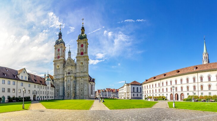
Just over an hour by train from Zurich, the lovely town of St. Gallen holds a treasury of Baroque buildings, making its streets a delight to stroll. Foremost of these is the magnificent Abbey of St. Gall, a former monastery founded in the early 700s, and for many centuries one of the most influential Benedictine abbeys in Europe and an important center of culture and learning.
The highlight of the abbey is the library, a magnificent hall under a Baroque ceiling with frescoed medallions framed in elaborate gold-washed scrolls and flourishes. The ranks of shelves and the exquisite curving gallery are finely detailed and embellished in inlaid woods. It is one of the world's oldest monastic libraries.
The former abbey church, itself a masterpiece of Baroque architecture and decoration, is now the Cathedral of St. Gallen. The abbey complex is a UNESCO World Heritage Site. Take time to visit the Textile Museum, with beautifully presented exhibits of textile arts that range from ancient Egyptian lace to modern textiles. St. Gallen was a center for textiles, and the linen woven here was known as "white gold' for its finesse.
12. The Spa Town of Baden
On the shores of the Limmat, the same river that flows through the center of Zurich, Baden was known for its thermal springs as far back as Roman times. The therapeutic waters of its hot springs have the highest mineral concentration of any of Switzerland's many spas.
While many of the spas and hotels offer luxury wellness programs, there are plenty of places for the public to bathe in the pools fed by the hot springs. Some of these are free, such as the Thermalbank, an eight-meter-long bench where you can soak your feet in the hot waters.
Opening in 2021, the city's stunning new bathing center was designed by Ticino Architect Mario Botta, and includes cafés and gathering spaces along with bathing pools.
More attractions bring tourists to Baden, including its charming medieval center of towers and half-timbered houses, and a world-class art museum. The Langmatt Foundation is one of Switzerland's finest collections of art from the Impressionist period. Baden is a 20-minute train ride from Zurich's central station.
13. Glarus
South of the Walensee and an easy drive or train ride from Zürich, the little canton of Glarus occupies one of the most beautiful valleys in the Alps. Rising above it on the west is the 2,332-meter ridge of Glärisch, and the massive bulk of Tödi, at 3,614 meters, closes its southern end.
From Linthal, a cableway connects to the traffic-free resort of Braunwald, an ideal jumping-off point for walking and climbing. Although the Freulerpalast in Näfels has a magnificent Renaissance doorway and Early Baroque interior that houses the Cantonal Museum, the main attractions for tourists are not architecture or museums but the scenic splendor of Glarus and its opportunities for outdoor adventures.
You can drive, take a post bus, or walk from Netstal to cross the Schwammhöhe into the high Klöntal, one of the most beautiful and romantic of Alpine valleys, with the Klöntalersee and a series of tumbling mountain streams.
Above the south side of the Klöntalersee rear the rock walls of Glärnisch, and below them is the canton capital of Glarus. The drive over the Klausen Pass to Altdorf is breathtakingly beautiful, and continues down the Schächen valley, where you'll find the 93-meter-high Staubi waterfalls.
14. Regensberg
About 18 kilometers northwest of Zürich, Regensberg is one of the best-preserved medieval towns in Switzerland. Among the carefully restored old burghers' houses is the half-timbered Rote Rose (Red Rose) house from 1540.
The five-story round tower (Rundturm), whose walls are three meters thick, is all that remains of the 12th-century castle. The rest dates from the 16th century, including the 57-meter-deep draw-well, the deepest in the country. Inside the tower is a small museum of the castle's and town's history.