11 Top-Rated Attractions & Things to Do in Maastricht, Netherlands
The capital city of the province of Limburg and close to the borders of both Germany and Belgium, Maastricht is undoubtedly one of the most beautiful cities in the Netherlands. Set along both banks of the River Maas, it's also one of the country's busiest commercial and tourist centers.
Founded by the Romans in 50 BCE on an important crossing point on the Maas where two military roads met, Maastricht was fortified in the 3rd century and again in the 14th century. The city changed hands many times through the years and suffered numerous sieges, leading to many interesting architectural influences that are still very evident to this day.
The signing of the Maastricht Treaty in 1992 saw the city become the symbol of the European Union, with the first meeting of the original 12 member states being held here. Attractions for tourists in Maastricht range from well-preserved medieval churches to museums filled with art treasures.
But with all its historic and artistic treasures, one of the best things to do in Maastricht is to simply enjoy strolling the many atmospheric streets and riversides of this immensely pedestrian-friendly city.
Learn more about the best places to visit with our guide to the top attractions in Maastricht.
See also: Where to Stay in Maastricht
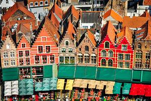
- 1. Wander around City Hall and Market Square
- 2. See the Treasures of Saint Servatius
- 3. Explore Fort Sint Pieter and the Caves of Maastricht
- 4. Tour the Basilica of Our Lady
- 5. Bonnefanten Museum
- 6. Walk the Old Town Walls and Hell Gate
- 7. Take a Stroll along Wilhelminabrug and St. Servaasbrug Bridges
- 8. Take a Trip to Romantic Valkenburg
- 9. See a Working Watermill at De Bisschopsmolen (Bishop's Mill)
- 10. Learn about the Past at the Natural History Museum
- 11. Museumkelder Derlon
- Where to Stay in Maastricht for Sightseeing
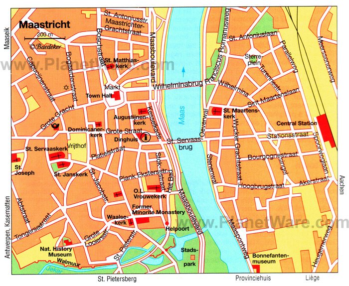
- Map of Attractions & Things to Do in Maastricht, Netherlands
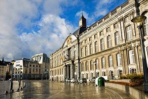
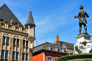
1. Wander around City Hall and Market Square
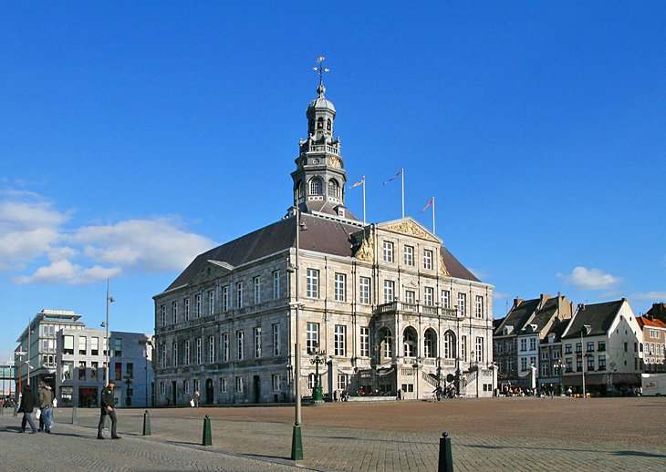
The best way to get to know Maastricht is to wander its many people-friendly streets and laneways. Start your self-guided walking tour at the city's focal point, the lively Market Square (Markt).
Many pleasant cafés line the edges of Market Square, which on Wednesday or Friday is the scene of a centuries-old food market; on Saturdays, it's the turn of a flea market that's popular with locals and visitors alike. Stop here for a treat before venturing out to the city's top tourist attractions, most of which are an easy stroll away.
Among the most important landmarks here is the Dutch Baroque Stadhuis, Maastricht's city hall. Built in the 1650s as a Cloth Hall, it's notable for its fine neoclassical façade with a handsome doorway approached by an imposing double staircase. The matching stairs were designed to enable the two rulers of Maastricht, the Duke of Brabant and the Prince-Bishop of Liège, to enter simultaneously.
Notable features of the interior are its tapestries, stucco ornamentation, ceiling paintings, and fine chimneypieces. Guided tours are available and are well worth doing; they are available Monday to Friday.
Address: Markt 78, 6211 CL Maastricht, Netherlands
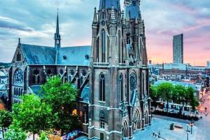
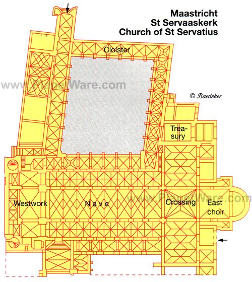
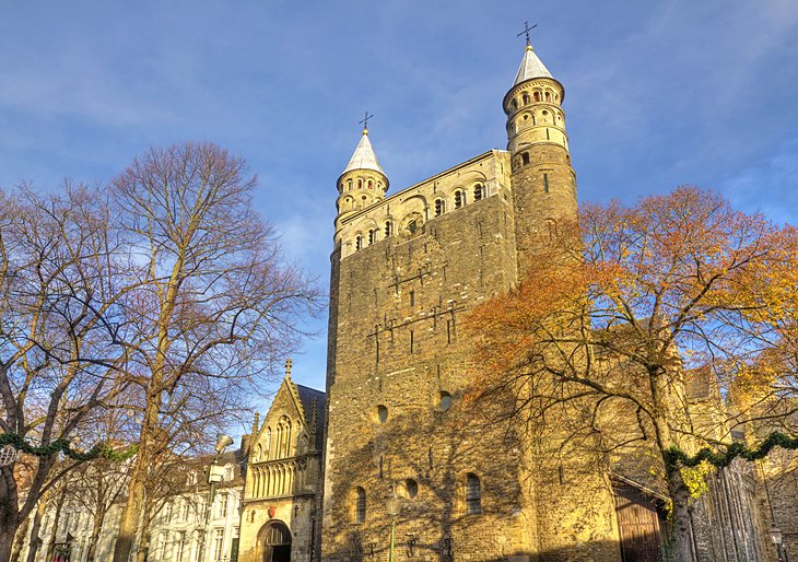
2. See the Treasures of Saint Servatius
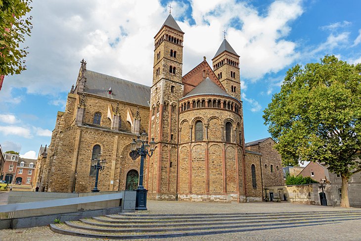
Built in the 6th century atop the grave of St. Servatius, the first Bishop of Maastricht, the Roman Catholic Basilica of St. Servaaskerk (Sint Servaas basiliek Maastricht) is the oldest church in the Netherlands. An easy 10-minute walk away from the Market Square, highlights of a visit include seeing the Imperial Hall and the Imperial Gallery, built between 1165 and 1677.
You'll also see the fine south doorway known as the Bergportaal, with its Biblical statuary from the 13th century. Other notable features include the cloister and the splendid vaulting of the nave and transepts added in the 14th and 15th centuries.
The most important part of the old church, however, is its rich Treasury, now a museum called The Treasures of St. Servaaskerk. Prime exhibits here include a variety of sacred objects, pictures, and statues, as well as the Late Romanesque chest reliquary housing the remains of St. Servatius, who died in 384 CE. This masterpiece of metalwork is known as the Noodkist, or Distress Chest, and is carried around the town whenever calamity threatens.
Also of interest is the crypt, home to the tomb of Charles of Lorraine, a statue of Charlemagne, and the remains of a 12th-century altar. English-language guided tours are available, and if possible, try to time your visit to coincide with one of the church's frequent concerts. Visitors are also welcome to attend mass.
Address: Keizer Karelplein 3, Maastricht, Netherlands
3. Explore Fort Sint Pieter and the Caves of Maastricht
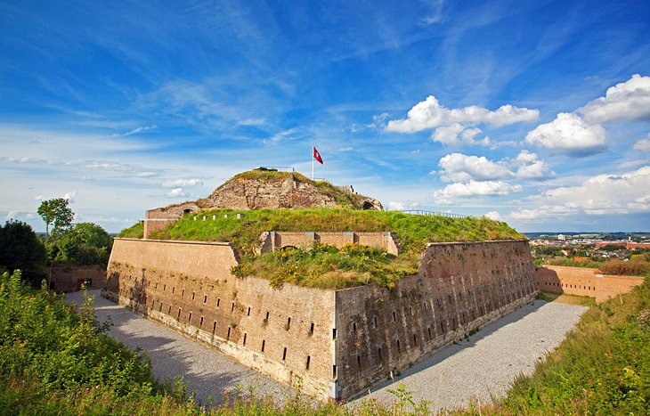
Mount Saint Peter (Caestert Plateau), the northernmost section of a large plateau stretching between Maastricht and the city of Liège in Belgium, is well-known as a nature reserve and recreational area. It's also where you'll find the historic 18th-century Fort Sint Pieter.
Built to defend the city from the French, this well-preserved fort is a delight to explore, both above ground and underground. Underneath the fortress and the "mountain" are the famous Caves of Maastricht. Also known as the St. Pietersberg Caves and the caves of Mount Saint Peter, this large system of tunnels and passages was formed over many centuries by the quarrying of local marlstone.
Some 20,000 passages with a total length of 200 kilometers once existed here, some of them enlarged with storerooms, a bakery, and even a chapel, during World War II. The caves were also used to protect art treasures, including Rembrandt's Night Watch, during the war.
The caves can be explored as part of a fascinating guided tour. Along with their historic interest, they also offer the chance to see evidence of ancient fossils.
Address: Luikerweg 71, Maastricht, Netherlands
Read More: Best Places to Visit in the Netherlands
4. Tour the Basilica of Our Lady
The impressive Basilica of Our Lady (Basiliek van Onze-Lieve-Vrouw) was built around 1000 CE. Although only a portion of the original survives, it's well worth including on your Maastricht travel itinerary. In about 1150, the crypts and the transepts were added, while the east choir was built in the early 1200s, followed by the gallery over the ambulatory.
The fortress-like character of the Romanesque west front, with its two stair turrets, recalls the church's former function as part of the town's fortifications. The Late Gothic choir with its large crypt is particularly pleasing, as is the side chapel containing the image of Our Lady Star of the Sea dating from the 15th century.
Other features of interest are the west crypt, which belonged to the earlier church, the church treasury, the beautiful 16th-century cloister, and the west tower. Guided tours are available, as are public organ recitals.
Address: Onze Lieve Vrouweplein 7, 6211 HD Maastricht, Netherlands
5. Bonnefanten Museum
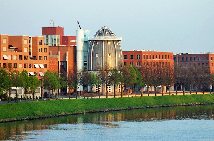
Situated on the banks of the River Maas in an ultra-modern building that resembles a 1950s version of a rocket ship, the superb Bonnefanten Museum displays Maastricht's most important art collections.
Named after the museum's former convent home, which was known as the Bonnefanten for its well-behaved children, the "bons enfants," this palatial edifice with its massive conical tower (the aforementioned rocket ship) houses a sizeable collection of important artworks. Its collection includes numerous paintings from the Dutch Masters, as well as many Italian and modern works.
Also in the museum are rich collections of medieval art, including wooden sculptures from the 13th to 16th centuries. English-language guided tours are available with advance notice.
Address: Avenue Ceramique 250, Maastricht, Netherlands
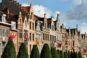
6. Walk the Old Town Walls and Hell Gate
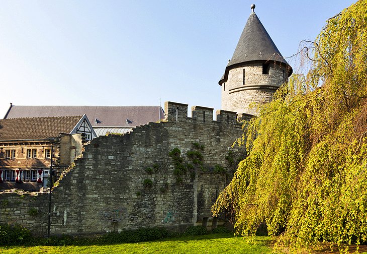
Maastricht's Old Town preserves entire segments of the first circuit of town walls, which are a delight to include in your walking tour of this historic city. Built around 1229, the wall's most impressive sections are Hell Gate (Helpoort) on St. Bernardusstraat, the oldest town gate in the Netherlands.
Also worth seeing is the Jeker Tower. Named after the river it stands close to, it's a focal point of the Jekerkwartier neighborhood with its attractive old townhomes and alleyways.
Also of note is Onze-Lieve-Vrouwewal. This stretch of old city walls offers fine views over the municipal park with its old cannons, as well as over the Maas. The remnants of the town's second circuit of walls date from around 1350.
Address: Sint Bernardusstraat 24b, 6211 HL Maastricht, Netherlands
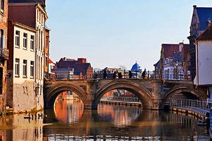
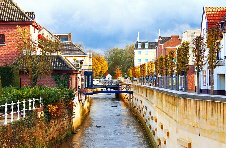
7. Take a Stroll along Wilhelminabrug and St. Servaasbrug Bridges
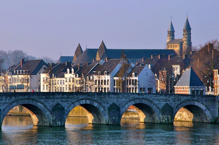
The Wilhelminabrug, a bridge built over the River Maas in the early 1930s, is a good place to visit to begin a walking tour of Maastricht's picturesque riverside districts. From here, head to St. Servaasbrug. This splendid seven-arched bridge was built in the 13th century and is notable for its statue of St. Servatius.
Be sure to also visit the historic Wyck District. Located on the right bank of the Maas, it's popular for its remnants of the old town wall. It's also a popular shopping and dining area, and features a number of good places to stay, too, including the trendy Dutch Hotel.
Address: Wilhelminabrug, Maastricht 6221, Netherlands
8. Take a Trip to Romantic Valkenburg
Home to the only hilltop castle in the Netherlands, Valkenburg, just 13 kilometers east of Maastricht, has long been a popular holiday resort thanks to its splendid spas. By far the most popular is Thermae 2000, one of the country's largest spa establishments and famous for its warm spring-fed baths and pools, healing mineral waters, and botanical garden.
The old town itself is fun to explore. Be sure to see St. Nicolaaskerk, a Late Gothic church dating from the 14th century with a splendid triptych depicting scenes from the life of St. Remigius.
Other attractions in the old town are its numerous handsome old houses, such as 17th-century Huis Den Halder, and the even older 15th-century Huis Ost. Along the way, you'll also come to another section of the old town walls, remnants of the 14th-century fortifications, along with the two town gates: the Grendelpoort and the Berkelpoort.
9. See a Working Watermill at De Bisschopsmolen (Bishop's Mill)
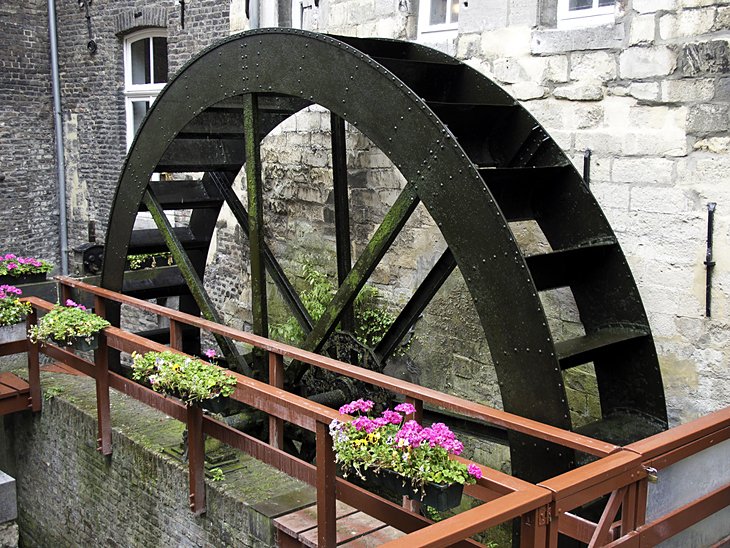
One of the surprises you'll find in wandering through Maastricht's back streets is a working water mill. Built in the 14th century on the Jeker River, the old Bishop's Mill (De Bisschopsmolen) is not only still operating much as it did when originally built, but it also continues to produce a variety of flours and grains, which are made into breads and pastries at the adjoining bakery.
Take a break in the bakery's café and sample the local specialty, Limburgse vlaai. This delicious lattice-topped pie is filled with your choice of cherries, plums, or apricots.
Address: Stenenbrug 3, 6211 HP Maastricht, Netherlands
10. Learn about the Past at the Natural History Museum
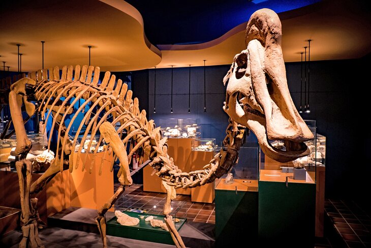
Although small, Maastricht's Natural History Museum (Natuurhistorisch Museum Maastricht) is well worth a visit. Located in a former monastery in the historic Jekerkwartier district, it's notable for its displays illustrating the geological development of the region through exhibits of fossils and local rock types.
Highlights include a fascinating cabinet of curiosities where you'll find a rare example of a 'rat king', a group of rats joined together by their tails. A biological section with collections of regional flora and a botanical garden on the banks of the River Jeker are also of interest.
Address: De Bosquetplein 7, 6211 KJ Maastricht, Netherlands
11. Museumkelder Derlon
Another of Maastricht's smaller museums worth seeing is Museum Derlon. Located in the basement of the Derlon Hotel, the museum focuses on Roman ruins and artifacts dating from the 2nd to 4th centuries that were discovered during renovations in the early 1980s. A visit reveals sections of the old Roman fort, as well as a sanctuary that includes parts of a temple.
Other highlights include a section of cobblestone road, believed to be of Celtic origin; the façade of a sanctuary entrance from around 150 CE; and the base of a statue of Jupiter. You'll also see the remnants of the old Roman walls and gateway, and numerous items of pottery, glass, and metal.
Address: Plankstraat 21, 6211 GA Maastricht, Netherlands
Where to Stay in Maastricht for Sightseeing
Most of the top tourist attractions in Maastricht lie in the compact city center along both sides of the Maas river, and this is the best place to stay if you're visiting for the first time. On the west bank, you'll find the Basilica of St. Servatius, the Museum aan het Vrijthof, the old town, and the two main squares, Vrijthof and the Markt. On the other side of the Maas river, the hip Wyck district is also a popular place to stay and is still within walking distance of the old town. Below are some highly-rated hotels in convenient locations:
Luxury Hotels:
- A four-minute stroll to the Basilica of St. Servatius, the evocative Kruisherenhotel Maastricht occupies a light-filled, renovated 15th-century monastery and its Gothic church.
- In the heart of the old town near posh shops and restaurants, the boutique Derlon Hotel Maastricht has an on-site restaurant and an intimate ambience, while the pet-friendly Crowne Plaza Maastricht overlooks the river on the east bank, a short stroll to the old town on the other side.
Mid-Range Hotels:
- Opposite the central train station in Wyck, the quirky, boutique Kaboom Hotel is about a 12-minute walk from the Bonnefanten Museum and offers excellent value.
- Right nearby, the aptly named Designhotel Maastricht is decorated in high style, with bold modern art and a trendy feel. Pets are welcome.
- Also nearby, Townhouse Hotels & Apartments has a homey feel with a bright book-filled living room and free soup on arrival.
Budget Hotels:
- Right on the Markt, Hotel De la Bourse offers compact, cozy rooms above a busy restaurant.
- In a great location between the Maas river and the Markt, Hotel d'Orangerie has quaint rooms in a building dating from 1752.
Map of Attractions & Things to Do in Maastricht, Netherlands