13 Top-Rated Tourist Attractions in Newfoundland and Labrador
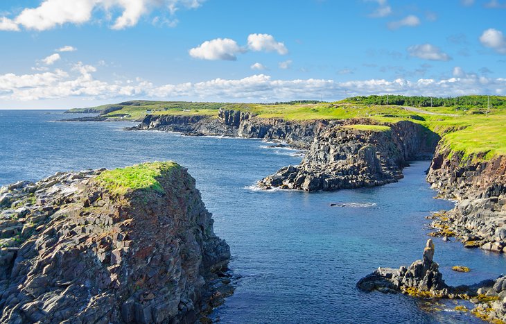
The island of Newfoundland is the most easterly part of Canada, while the vast region of Labrador is largely inaccessible. Newfoundland and Labrador's varied landscape was shaped by the ice ages, leaving a ragged coastline of deep fjords and high coastal cliffs that plunge into the sea. Inland are miles and miles of moorland and forest studded by lakes and inhabited by moose and herds of caribou.
Because of its location close to the "Grand Banks," some of the world's richest fishing grounds, the island's main livelihood was cod fishing until foreign factory ships so depleted the cod population and habitat that the Canadian government suspended fishing.
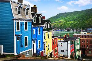
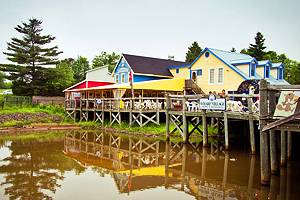
The capital city of St. John's (not to be confused with the city of Saint John in New Brunswick), around which about a fifth of Newfoundland's population lives, is a lively town with a charming provincial feel to it. All around the island's irregular coast are towns and remote former fishing villages that attract tourists with their breathtaking scenery, sea life, and exceptional birding sites.
Miles and miles of trails follow the magnificent coast, and historic sites to tour include the first known Viking settlement, landing sites of early European explorers, landmarks of early flight pioneers, and tangible relics of prehistoric populations. To pronounce the names like a native, accent the last syllables, as in NewfoundLAND and LabraDOR.
Plan your next great north adventure with our list of the top tourist attractions in Newfoundland and Labrador.
- 1. Gros Morne National Park
- 2. L'Anse aux Meadows National Historic Site
- 3. Signal Hill National Historic Site
- 4. The Rooms
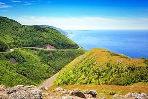
- 5. Bonavista Peninsula
- 6. Cape Spear Lighthouse National Historic Site
- 7. Torngat Mountains National Park
- 8. Puffin and Whale Cruises in Witless Bay
- 9. Cape St. Mary's Ecological Reserve
- 10. Twillingate and Fogo Island
- 11. Castle Hill National Historic Site
- 12. Terra Nova National Park
- 13. Red Bay National Historic Site
- Map of Tourist Attractions in Newfoundland and Labrador
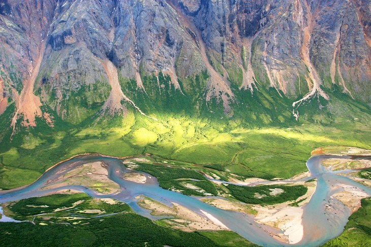
1. Gros Morne National Park
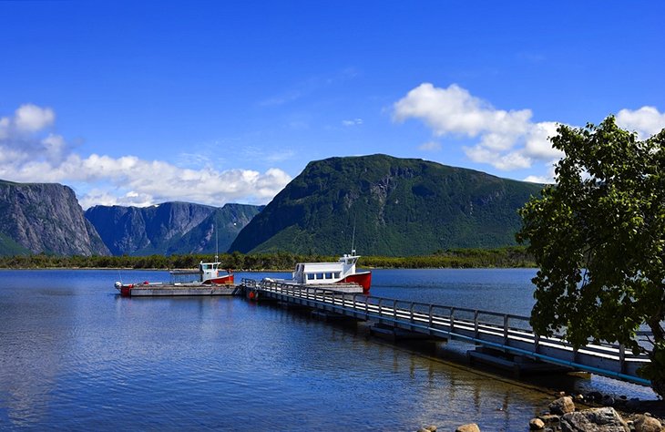
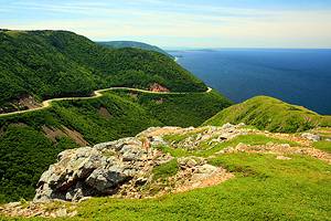
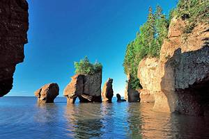
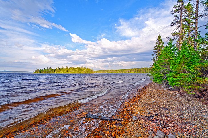
Gros Morne National Park is undoubtedly one of the most impressive natural features in eastern Canada, a magnificent landscape of fjords and mountains, partly covered with dense forest. Unique wildlife and plant life has adapted to the cold conditions, which are found scarcely anywhere else so far south.
This is one of Newfoundland's most popular attractions, with hiking trails and sightseeing boat excursions in the dramatic landlocked fjord at Western Brook Pond. Other popular things to do here include rock-climbing, boating, swimming, camping, and fishing.
Within the national park, the Long Range Mountains are among the oldest mountains on earth and have been shaped by advancing ice and the forces of erosion. Gros Morne National Park is a UNESCO World Heritage Site, largely for its unique geological phenomena.
At Tablelands, a large piece of the earth's mantle was thrust to the surface by colliding tectonic plates, exposing a piece of earth that is elsewhere more than a mile beneath the surface. At Greenpoint, ancient layers of solidified seabed have been thrust into vertical cliffs, exposing fossil sequences of different eras.
Official site: http://www.pc.gc.ca/eng/pn-np/nl/grosmorne/index.aspx
2. L'Anse aux Meadows National Historic Site
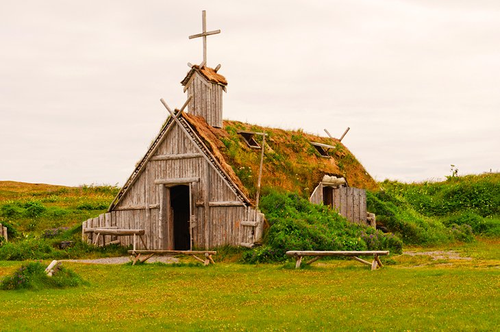
L'Anse aux Meadows National Historic Site, a green plain with some moorland, lies at the northern tip of Newfoundland's Great Northern Peninsula. Here were discovered six houses made of grass sods, probably built by the Vikings around the year 1,000 and rediscovered in 1962. It is the oldest known European settlement in North America and, to date, is the only authentic trace of Viking settlement in the New World. It is probably the "Vinland" discovered by Leif Erikson.
The historic site has a reconstructed long house, workshop, and stable where costumed interpreters demonstrate age-old tasks and answer questions. A second Viking attraction on the Great Northern Peninsula is Norstead, a living-history museum with a slightly livelier feel and more Viking-style buildings.
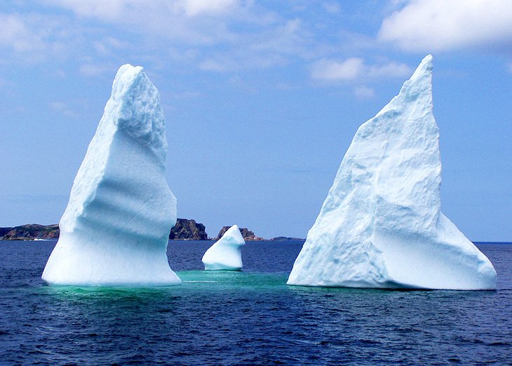
The Viking Trail is a signposted route that takes tourists the length of Newfoundland's Northern Peninsula, from Gros Morne to L'Anse aux Meadows and across the Strait of Belle Isle into Labrador. Almost its entire route is along the western shore overlooking the strait, an expanse of sea that is known as Iceberg Alley.
In the spring and summer, it is not at all unusual to see both icebergs and whales from the road, often at the same time. On its way up the coast, the Viking Trail passes a number of attractions, including the rock formations of Arches Provincial Park and the aboriginal burial ground of Port au Choix National Historic Site, one of the richest archaeological finds in North America.
Official site: http://www.pc.gc.ca/eng/lhn-nhs/nl/meadows/index.aspx
3. Signal Hill National Historic Site
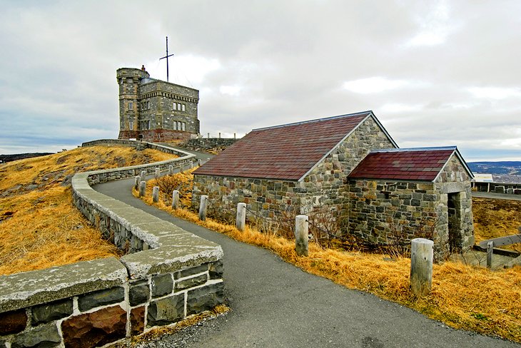
Atop its namesake hill, Signal Hill National Historic Site overlooks the Atlantic Ocean, St. John's harbor, and the small historic downtown. In 1901, Guglielmo Marconi received the first transatlantic wireless signal here. The landmark Cabot Tower commemorates the 400th anniversary of John Cabot's voyage.
Hiking trails lead to the fortifications at the Queen's Battery Barracks and along the perilous cliffs, including spectacular but difficult North Head Trail down to Battery Road.
Official site: http://www.pc.gc.ca/eng/lhn-nhs/nl/signalhill/index.aspx
4. The Rooms
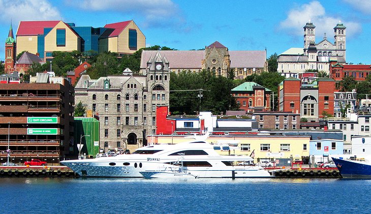
Dominating the hilltop in sharp contrast to the neighboring 19th-century Romanesque Revival-style Catholic Basilica, St. John's newest museum is called The Rooms and includes several different collections divided by subject. Sections include wildlife and natural history, aboriginal finds, contemporary art, and historical and cultural exhibits that give a good picture of both Newfoundland and Labrador. The museum has a popular restaurant and some of the best views over the city and Signal Hill.
Address: 9 Bonaventure Ave, St. John's, Newfoundland
Official site: https://www.therooms.ca/
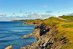
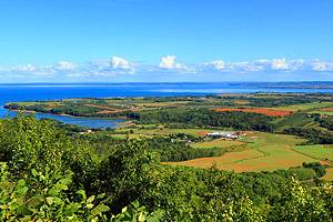
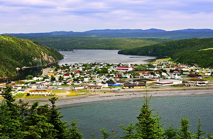
5. Bonavista Peninsula
The best-known peninsula in Newfoundland is Bonavista, where John Cabot is thought to have sighted the "New World" for the first time in 1497. At Cape Bonavista, stands a statue of Cabot, and visitors can watch for whales, puffins, and icebergs along the coast. The old lighthouse, a provincial historic site, dates from 1843 and was restored around 1870. Picturesque Trinity is an old fishing and trading town, where the historical character has been well preserved.
Also a fishing town, Bonavista was first used by European fishing fleets back in the 16th century. Ryan Premises National Historic Site was opened in 1997. This was originally the headquarters for James Ryan Ltd, a company that began operations in 1869 trading salted fish.
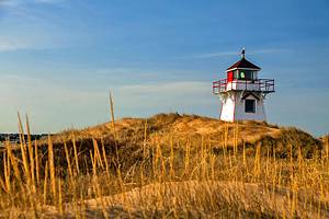
6. Cape Spear Lighthouse National Historic Site

Cape Spear Lighthouse National Historic Site, 11 kilometers south of St. John's, is the most easterly point in North America, and has Newfoundland's oldest lighthouse. It is a popular, if chilly, spot to watch the sunrise as well as sight whales, seabirds, and icebergs.
Dating from 1835, the light station was in operation until 1955 and is now an interesting museum. In addition, there are massive half-ruined gun emplacements from the Second World War, including the barrels of two guns each weighing 30 tons and having a range of 13 kilometers.
Official site: http://www.pc.gc.ca/eng/lhn-nhs/nl/spear/index.aspx
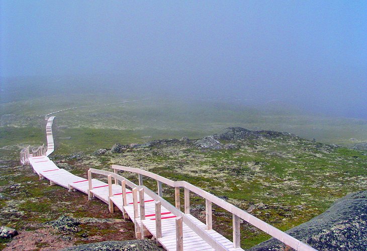
7. Torngat Mountains National Park
Torngat Mountains National Park occupies the northernmost tip of Newfoundland and Labrador, facing east toward Greenland. A trip to this remote area is not for the faint of heart, but is tremendously rewarding for those willing to truly travel off the beaten path. This national park has no roads and no signage, and can only safely be visited by arrangement with park officials at the Torgnat Mountains Basecamp and Research Station.
The first thing to strike most visitors is the landscape, dramatic in its grand scope and vastness. The coastline is jagged, with fjords filled with crisp blue water, and the mountains inland are among Canada's tallest peaks. Iceberg viewing is one of the most popular activities here along "iceberg alley," with massive chunks of glacial ice visible from both land and sea. Although icebergs can be spotted as far south as the island of Newfoundland, the season for seeing them is much longer in these far-north reaches.
Boat tours are one of the best ways to view the fjords and icebergs, but are also the best way to admire the astounding number of whales that make the coastal waters home each summer between May and September. This is where you will find the world's biggest group of humpback whales, and plentiful pods of other species, including pilot whales, sperm whales, orca, sperm whales, and minke. Tourists will also spot dolphins and harbor porpoise, and polar bears can be found swimming in the water along the coast and roaming the vast landscape.
Bird-watchers will appreciate the 350 species of fowl that call the area home, including a population of over 800 bald eagles and plentiful other birds of prey like owls, falcons, osprey, and hawks. Other bird species include flocks of millions of storm-petrels, thousands of gannets, and murres.
One of the most special parts of visiting this unique park is the opportunity to learn about Inuit and culture. The parkland is owned by the Inuit peoples, and they welcome visitors to learn more about their heritage through museums, historic sites, festivals, and events. Inuit guides also conduct hiking tours, as well as kayak and raft excursions and fishing trips.
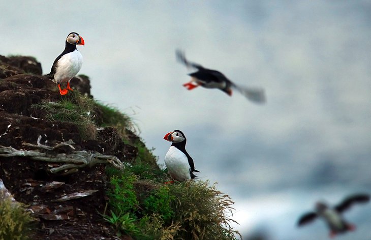
8. Puffin and Whale Cruises in Witless Bay

Boat cruises to the islands, where puffins nest and to observe the whales that frequent the Witless Bay Ecological Reserve leave from the town of Bay Bulls, south of St. John's. Whales follow the icebergs that are also found in the bay, and it is not unusual to see icebergs, whales, and puffins, as well as other sea birds on a single cruise.
The four islands of the reserve are the nesting sites for more than 260,000 pairs of puffins, North America's largest Atlantic puffin colony. This is also the world's second-largest Leach's storm-petrel colony, consisting of more than 620,000 pairs that nest here, and you will almost certainly see some of the thousands of black-legged kittiwakes and common murres that spend the summer here.
Puffins are the province's official bird, and tour boats give a close-up view of these appealing birds and their nesting sites during the late spring and summer.
9. Cape St. Mary's Ecological Reserve
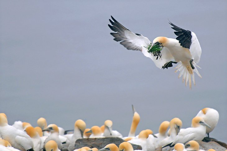
There are major colonies of seabirds at Cape St. Mary's, including about 24,000 northern gannet. The birds are a spectacular sight, whether nesting on the rocks or dive-bombing the ocean for a meal. Other seabird species at the cliff-side reserve include black-legged kittiwake, common murre, razorbill, and great cormorant.
10. Twillingate and Fogo Island
The traditional Newfoundland fishing village of Twillingate is located on the northern coast, known as the Kittiwake coast, and it is a good place to visit to experience local village life. Twillingate was originally settled in 1738 and known as Toulinguet. Near Twillingate is the Long Point Lighthouse, built in 1889. It has a range of 40 kilometers and is an excellent location to watch for whales and icebergs.
Small museums and seafood restaurants make the community an interesting stop for tourists; don't miss the Twillingate Museum & Crafts Shop for a selection of local art and handwork. This is also a popular starting port for iceberg cruises.
Nearby Fogo Island is a holdout from the days of fishing outports. The island culture and an old Irish dialect are distinct from that on the main island of Newfoundland. In recent years, the addition of an expansive artist retreat and luxury hotel have brought attention and visitors to this coastal island.
11. Castle Hill National Historic Site
Castle Hill National Historic Site is between Highway 100 and Placentia, where one of the two ferry routes to Nova Scotia begins and ends. It is the site of historic English and French fortifications, and an interpretive center. The French founded the colony of "Plaisance" in 1662 and built Fort Royal in 1693. But only 20 years later they handed over the strategic location to the British, who renamed it Castle Hill. There is a magnificent view over Placentia Bay.
Official site: http://www.pc.gc.ca/eng/lhn-nhs/nl/castlehill/index.aspx
12. Terra Nova National Park
Terra Nova National Park is known for its fjords and quiet coastline. In spring, icebergs drift by, and in summer, kayakers and canoeists take to the waters, while families fill the park campgrounds. Winter offers cross-country skiing opportunities.
Just north of the national park, Salvage is a small fishing community with the classic Newfoundland charm of waterfront fishing sheds, tilting wharves, and rocky headlands.
Official site: http://www.pc.gc.ca/eng/pn-np/nl/terranova/index.aspx
13. Red Bay National Historic Site
The icy-cold Labrador current flows through the 17 kilometer-wide Strait of Belle Isle, which separates Labrador from Newfoundland, and into the Gulf of St. Lawrence. Since the 16th century, southern Labrador had been the summer fishing grounds of fishermen and whalers arriving from Europe and Newfoundland.
At Red Bay National Historic Site, the remains of Basque (Spanish) whaling boats have been recovered. An interpretive center pieces together the historical clues.
Official site: http://www.pc.gc.ca/eng/lhn-nhs/nl/redbay/index.aspx