16 Top-Rated Tourist Attractions in Naples & Easy Day Trips
Even if you've been to many Italian cities, nothing prepares you for the exuberant, colorful, and sometimes chaotic hubbub of Naples. The entire population seems to be in the streets that spill down into its harbor, and they're all talking at once.
Colors here seem brighter, and aromas of pizza–Neapolitans claim to have invented it–waft through the air, along with operatic areas (everyone here is a tenor waiting to be discovered), laughter, and maybe an argument or two. It's a city that will keep all your senses busy.
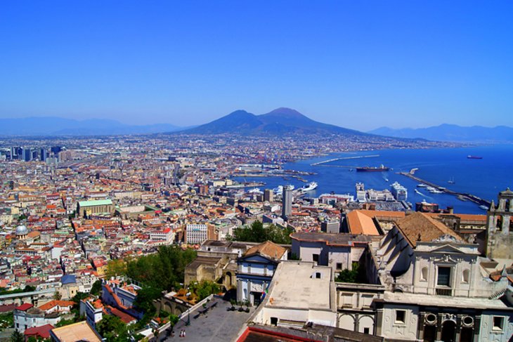
That's not to say it doesn't have a bounty of things to do and attractions for tourists. One of the world's finest archaeological museums holds the treasures of nearby Pompeii, and much more. For centuries, Neapolitans have lavished attention and riches on their magnificent churches, while royalty of several great houses of Europe have decorated its palaces.
The city's long history, dating back to the Greeks in the eighth century BC, included Byzantine, French, Spanish, and Austrian rule, each of which left its mark. And beyond the churches, palaces, and museums, the narrow neighborhood streets, broad promenades, and parks you'll find while exploring Naples are sights in their own right. Find more great places to visit here and nearby with our list of the top tourist attractions in Naples.
See also: Where to Stay in Naples
- 1. Castel Ovo and the Lungomare
- 2. National Archeological Museum
- 3. Cappella Sansevero
- 4. Capodimonte Royal Palace and Museum
- 5. Castel Nuovo
- 6. Catacombs of San Gennaro
- 7. Shopping for Presepi on Via San Gregorio Armeno
- 8. Palazzo Reale (Royal Palace)
- 9. Teatro di San Carlo
- 10. Shopping at Galleria Umberto I
- 11. San Martino Monastery and Museum
- 12. Cathedral
- 13. Galleria Borbonica (Bourbon Tunnel)
- 14. San Domenico Maggiore
- 15. Santa Chiara
- 16. Exploring Santa Lucia
- Where to Stay in Naples for Sightseeing
- Day Trips from Naples
- Pompeii
- Herculaneum
- Vesuvius
- Amalfi Coast
- Caserta Palazzo Reale
- Capri
- Ischia
- Benevento and the Arch of Trajan
- Castellammare di Stabia
- Capua
- Map of Tourist Attractions in Naples & Easy Day Trips
- Naples, Italy - Climate Chart
1. Castel Ovo and the Lungomare
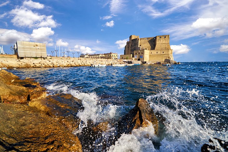
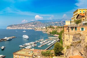
Along the waterfront, at the historic gateway to the Mediterranean and the world, you can get a feel for this vibrant city. Naples harbor is divided into separate docks and basins by a series of piers and breakwaters, and is always bustling with activity.
The Lungomare is a beach promenade that follows the shore for about 2.4 kilometers along Via Partenope and Via Francesco Caracciolo in the Chiaia neighborhood, with beautiful views across the bay to Vesuvius and plenty of cafés and ice-cream shops. Stroll here, enjoy the views and lively atmosphere, and sample Naples' contribution to food history–margherita pizza.
Sitting on a promontory at the end of Via Francesco Caracciolo is the 12th-century Castel Ovo, the oldest castle in Naples. The views of the harbor, ferries, bay, and Mt. Vesuvius are even better from its ramparts, and inside is an Ethno-Prehistory Museum with ceramics and other artifacts from ancient Naples. There is no charge for admission to the castle and museum, which, like the Lungomare, are among several free things to do in Naples.
Beyond the castle lies the busiest part of the Port of Naples, with the cruise port and departure point for ferries to Sicily, Sardinia, and elsewhere. Farther south, from the quay on the Calata di Beverello, boats sail to Ponza, Capri, and Ischia. Naples is the principal port for southern Italy, and the harbor is its heart.
Official site: http://www.castel-dell-ovo.com
2. National Archeological Museum
The Museo Archeologico Nazionale holds one of the world's finest collections of antiquities, many of which were brought here from early excavations of Pompeii. In fact, more of the city's artistic highlights are here than at the site itself. In addition, it has the art treasures of the kings of Naples, the Farnese collections from Rome and Parma, the collections from the palaces of Portici and Capodimonte, and material from Herculaneum and Cumae.
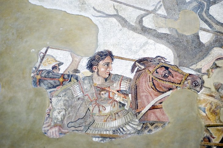
The ground floor is devoted mainly to marble sculptures, including the Farnese Hercules, a colossal 3.17-meter statue found in the Baths of Caracalla in Rome, and the Farnese Bull, the largest marble group that has come down from antiquity. On the mezzanine is the collection of ancient mosaics from Pompeii, including the famous 6.20-meter Alexander's Battle.
On the first floor (second floor to Americans), in the central Salone dell'Atlante, is the Farnese Atlas. Here, too, is the collection of bronze sculpture from Pompeii (recognizable by the green oxidation) and Herculaneum (with a dark patina). Look especially for Apollo Playing a Lyre, a 5th-century original from the Peloponnese, found in the Casa del Citarista in Pompeii.
Also on this floor is the remarkable collection of ancient wall paintings, mainly from Pompeii but also from Herculaneum and Stabiae. The bronze household utensils and other bronzes, terra-cotta vessels, and a large model of Pompeii are worth seeing, too.
Address: Piazza Museo 19, Naples
3. Cappella Sansevero
The Cappella Sansevero was built in 1590 as the private chapel of the Sansevero family and later became its burial chapel. In the 18th century, it was elaborately embellished in Baroque style by the eccentric mystic Raimondo di Sangro, Prince of Sansevero.
Of the sculptures that he commissioned, the most outstanding artistic features are in the ethereal Veiled Christ by Sammartino (1753) and two others that show the figures draped in what appears to be a translucent tissue of marble. Another, also carved from a single block of marble, shows a male figure partially wrapped in a net, free falling in places and so intricately carved that it seems impossible that it's really made of stone.
The chapel's most unusual exhibits are the pair of Anatomical Machines, demonstrating the human circulatory system and muscles, built on actual skeletons using wire, silk, and beeswax. Needless to say, the Prince's strange collection, added to all the Masonic symbols he incorporated into the chapel, gave rise to dark rumors about him and the scientific experiments he carried out in his adjoining palace.
Address: Via De Sanotic 17/21, Naples
4. Capodimonte Royal Palace and Museum

Intended originally as a hunting lodge for King Charles III, the Palazzo Reale di Capodimonte grew to become the royal residence and a place for the king to house the Farnese collection, which he had inherited. The collection includes portraits of members of ruling families by Titian and formed the basis for the National Gallery (Galleria Nazionale), one of the finest art collections in Italy, now housed here.
Its more than 500 pictures include, in addition to the Titians, works by Mantegna, Caravaggio, Raphael, Botticelli, El Greco, Bellini, and Neapolitan artists of the 17th and 18th centuries.
In the royal apartments, you'll find furniture, tapestries, and porcelain used in the palace during the Bourbon and Savoy dynasties. The small room, Salottino di Porcellana, is completely lined with porcelain.
In the park that surrounds the palace, which was the royal hunting grounds, King Charles III founded the Capodimonte workshops to produce ceramics. This highly decorative work became quite famous, and you'll see products of the workshop at the convent Santa Chiara. Wander in the beautiful park, along avenues shaded by huge trees, past battered statues and a pond.
Address: Via Milano 2, Naples
5. Castel Nuovo
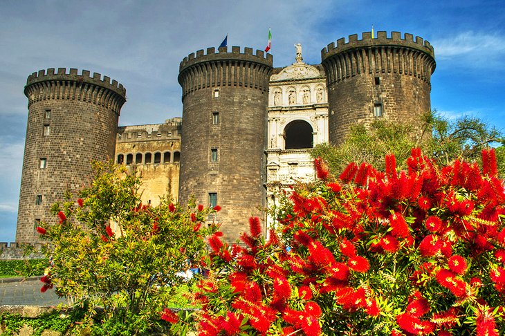
On the south side of the Piazza del Municipio, the five-towered Castel Nuovo, also known as the Maschio Angioino, was the residence of kings and viceroys of Naples. Its history reflects the various rulers–French, Aragonese, Spanish, and Austrian-–each adding and renovating to suit the times.
It was originally built by Charles I of Anjou in 1279-82, and was enlarged by Alfonso I of Aragon, who had the grand Early Renaissance Triumphal Arch between the towers added between 1453 and 1467 to celebrate his victorious entry into the city. Parts of it are used for events and expositions, but the Armoury Hall, the southern courtyard, the Charles V Hall, and the Sala della Loggia are usually open. In the courtyard is the Gothic church of Santa Barbara (or Cappella Palatina).
Address: Piazza Castello, Naples
6. Catacombs of San Gennaro
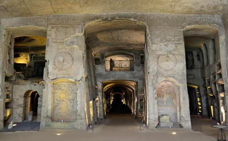
The second-century Catacombs of San Gennaro, like the Roman catacombs, are a maze of passages and tomb chambers but are more ambitious architecturally and have finer paintings than their Roman counterparts.
There are two levels of these, and in the upper catacomb's vaulting are frescoes from late in the second century. Here, too, is the small Crypt of the Bishops and the large underground basilica, with three naves cut into the stone and decorated with frescoes from the fourth through sixth centuries.
The basilica was built near the catacombs in the fifth century, and although it has undergone several changes, it is a rare example of early Christian architecture. Even after major renovations during the Aragonese era in the 14th and 15th centuries, its basic structure of three naves and a semi-circular apse remains.
Address: Via Capodimonte 13, Naples
Official site: http://www.catacombedinapoli.it/en/places/catacombs-of-san-gennaro-naples?ref=ok
7. Shopping for Presepi on Via San Gregorio Armeno
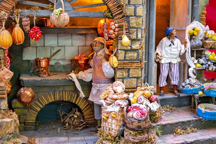
If you are looking for souvenirs that are unique to the city, terra-cotta Nativity figures are the best things to buy in Naples. But a stroll along Via San Gregorio Armeno is more than a chance to do some shopping in Naples, it is an experience in local life and culture.
During December, you'll find Nativity scenes, called presepi, in churches and public places all over Italy, but nowhere are they so elaborate as in Naples. The best-known craftsmen are here as well, and you will be astonished at the variety and finesse of some of these figures they create.
In Italy these presepi contain far more than the figures central to the night in Bethlehem. You'll find animals, buildings, shops, children, and entire villages of everyday activity surrounding the scenes, made of wood, ceramic, terra-cotta, plaster, and other materials, some dressed elaborately in sumptuous fabrics.
Miniature collectors will find tiny furniture, foods, animals, even entire shops and rooms. The most typical of Naples are the figures made of terra-cotta, and you'll find some of the most artistic at the studio of Giuseppe and Marco Ferrigno.
8. Palazzo Reale (Royal Palace)
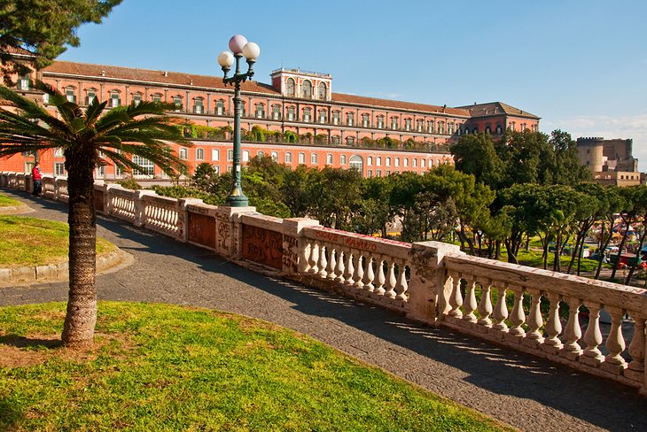
Along the east side of Piazza del Plebiscito is the former Royal Palace, begun in 1600 by Domenico Fontana and restored from 1837-41. It is one of four palaces in the area that were used as residences by the Bourbon kings. On the long facade are eight marble statues of the various kings who ruled Naples.
Inside, you can see the grand staircase of white marble, built in 1651, a theater, and more than two dozen rooms in its state apartment, with furniture, tapestries, porcelains, and sculptures. It's rarely crowded, inexpensive, and you get a free audio tour. Many tourists consider this one of Naples' most interesting and unsung attractions.
Address: Piazza Plebiscito, Naples
9. Teatro di San Carlo
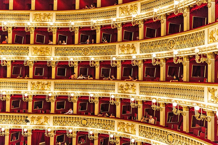
One of the largest theaters in Europe and one of Italy's premier opera houses, the Real Teatro di San Carlo was built by King Charles of Bourbon, adjoining his Royal Palace. It was completed in 1737, and along with being the oldest continuously active opera house in Europe, it was the model for opera houses everywhere. Six levels of ornately decorated boxes surround the interior, highlighted by the even more lavishly ornate royal box.
In addition to operas, performances include concerts and ballet. Along with its outstanding acoustics, San Carlo has the reputation of attracting the noisiest and worst-behaved audiences in Italy. Woe betides the tenor who misses his high C here.
Address: Via San Carlo 98, Naples
Official site: http://www.teatrosancarlo.it/en
10. Shopping at Galleria Umberto I
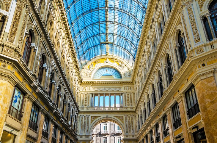
Whether or not you are a dedicated shopper, you'll want to see this popular attraction for its architecture and grandeur. Built between 1887 and 1891, Galleria Umberto I was named for Umberto I, then King of Italy. Designed as a public place for shopping, businesses, cafés, and social space, the tall building has four wings with iron and glass vaulting. These converge at the center under a glass dome, for spectacular effect.
One of the wings opens onto the San Carlo Opera House. Although the Galleria is no longer the center of Naples' café society, it is still a lively place to visit, with shops, restaurants, and cafés. The interior is decorated with sculptures and paintings.
Address: Via San Carlo 15, Naples, Italy
11. San Martino Monastery and Museum
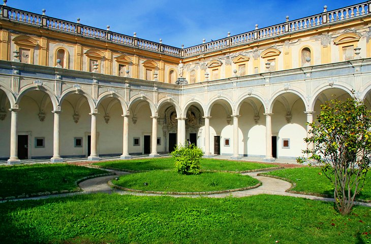
The former Carthusian monastery of San Martino, built in 1325 and rebuilt in the 17th century, also houses the Museo Nazionale di San Martino. The church, where you should also be sure to see the sacristy and treasury, is richly decorated with marble, ceiling frescoes, and paintings from the 17th and 18th centuries.
There are two cloisters, the Chiostro dei Procuratori and the main cloister, which is surrounded by 60 white marble columns. The monastery makes a good setting for the museum, which contains porcelain, an 18th-century state coach of Charles III's reign, and various historical relics from Naples and southern Italy in the 18th and 19th centuries.
If you're not in Naples during the Christmas season, when most churches are displaying the magnificent Nativity scenes (presepi) for which Neapolitan craftsmen are famous, you'll have a chance to see a collection of them here. It includes the Presepe di Cuciniello, an astonishingly detailed depiction of the Nativity with finely-carved animals, buildings, and figures dressed in intricately ornamented fabric costumes. From the Belvedere, superb views of Naples and its bay extend to Vesuvius and the island of Capri.
Address: Largo di San Martino 5, Naples
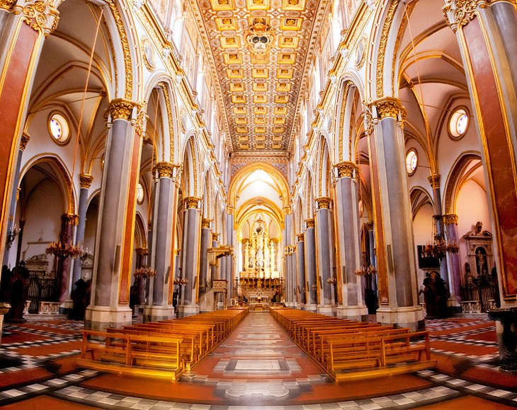
12. Cathedral
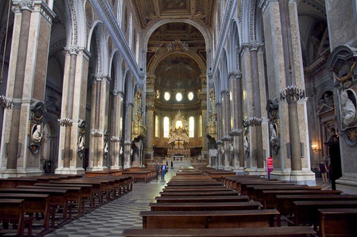
Although dating back to the late 13th century, the cathedral has been altered considerably due to earthquakes and restoration, especially after the one of 1456, but the 1407 doorway in the center of the front has survived. In the south aisle is the sumptuous 17th-century chapel of San Gennaro, patron saint of Naples. On its main altar, a silver bust contains the skull of the saint, who was martyred in 305, in the time of Diocletian.
You can see the saint's tomb in the richly decorated Confessio (1497-1506) under the high altar, and in the underground archeological area, you can see the 4th-century Basilica Santa Restituta, the oldest church in Naples, with excellent ceiling frescoes and columns from a Roman temple.
The Archbishop's Palace and several other churches surround the cathedral, among them the Gothic Santa Maria Donnaregina, with fine 14th-century frescoes by Giotto's contemporary Pietro Cavallini in the elevated nuns' choir, and the Baroque churches of San Filippo Neri and San Paolo Maggiore. Underneath the restored Gothic church of San Lorenzo Maggiore (1266-1324), an archaeological site allows visitors to see layer upon layer of civilization: Greek, Roman, Byzantine, and medieval.
Address: Via del Duomo, Naples
13. Galleria Borbonica (Bourbon Tunnel)
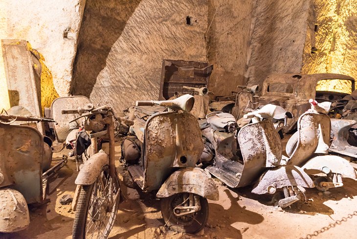
Definitely one of the most unusual things to do in Naples is exploring the unfinished underground passage known as the Galleria Borbonica–the Bourbon Tunnel. It was begun in the 19th century, on the instructions of King Ferdinand II, as a way for him to escape from the Royal palace to the safety of the military barracks on what is now Via Morelli.
It was never finished, but the carved tunnels were later used as an air raid shelter and emergency hospital during World War II.
Access to its huge galleries and spooky tunnels is by tour, during which you can see the cisterns and a variety of relics and debris from its various uses, including old cars, Vespas, motorcycles, and fragments of statuary and architectural detail.
Address: Vico del Grottone No. 4, Naples
14. San Domenico Maggiore
San Domenico Maggiore, built about 1300, is among the most beautiful and interesting churches in Naples, filled with Early Renaissance work. The ornate paneled ceiling leads your eyes directly to the high altar by Cosimo Fanzago.
Each of its 24-sided chapels contains something of interest, especially the Chapel of San Michele Arcangelo a Morfisa at the end of the right nave, which incorporates a 10th-century church. In the Cappellone Crocifisso are a 13th-century Crucification and the 15th-century Burial of Christ.
Beyond the chapel dedicated to Saint Thomas Aquinas (who studied here) is the sacristy, with a frescoed ceiling, Triumph of Faith over Heresy by the Dominicans, and a gallery of 45 sarcophagi belonging to members of the house of Anjou.
Address: Piazza San Domenico Maggiore, Naples
15. Santa Chiara
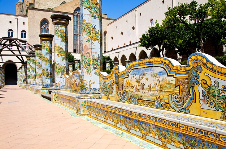
The cloister of the Monastery of Santa Chiara, founded in 1310, looks more like a park in a seaside resort town than a solemn retreat for nuns. Majolica tiles made at the Capodimonte workshops, in vivid colors and lively designs, cover the 66 octagonal columns surrounding its cloister, and between the columns are long benches also covered in tiles.
These seem to bring the secular world inside the monastery walls, with scenes from everyday life of their period–the mid-1700s. Under the porticos, the walls on all four sides of the cloister are covered with 17th-century frescoes of Old Testament scenes.
There are more reasons to visit Santa Chiara besides its surprising and beautiful cloister. Inside on the right is a presepio (Nativity scene) set in a Roman ruin, incorporating mundane daily Neapolitan life along with the sacred creche scene. The figures are dressed in typical local 18th- and 19th-century clothing. The setting in a Roman ruin is thought perhaps to reflect the intense interest in the discovery of Herculaneum in the early 18th century.
While repairing damage after World War II, the intact remains of a first-century Roman thermal spa were discovered, probably part of a villa. This and other finds from the first through fourth centuries make up a small archaeological area and museum.
16. Exploring Santa Lucia
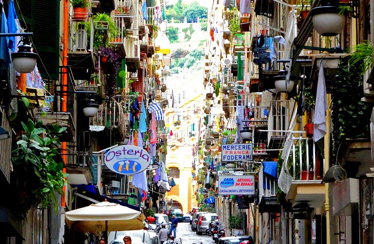
To the west of the Piazza del Plebiscito, on the slopes of Pizzofalcone and extending down to the sea, lies the district of Santa Lucia. South of the wide Via Santa Lucia, this is an area of modern streets laid out on a regular plan, but to the north, it is a picturesque huddle of narrow, stepped lanes where you can see–and be part of–traditional Neapolitan life.
It would be a shame to miss this very real neighborhood of shops and bakeries, artisans' workshops, little cafés where locals down their espresso, and streets where children play. Laundry usually hangs overhead, and conversations are carried on between balconies and windows across the narrow streets. It's a colorful place any time of day, but especially lively in the evening, making it one of the favorite things to do at night in Naples.
Where to Stay in Naples for Sightseeing
Popular tourist attractions in Naples are widely scattered, but two areas are convenient to several of them. These areas are not far apart, so your choice may depend on whether or not you enjoy being in a typical–and colorful–Neapolitan neighborhood throbbing with city life.
If you like feeling the pulse of a passionate city, crowded Decumani is for you, close to the Duomo, Archeological Museum, and several churches. The quieter option is the waterfront Chiaia neighborhood, the part of the more colorful Santa Lucia district, near the Palazzo Reale and the San Carlo opera house. Here are some highly rated hotels in and around these areas:
Luxury Hotels
- A Naples landmark for its elegant style and seafront setting in Chiaia, Grand Hotel Vesuvio caters to film stars and royalty. Its top-floor restaurant is the place for celebratory occasions, with its romantic views of the twinkling harbor lights.
- In the same upscale area and close to chic shops and dining is the Hotel Palazzo Alabardieri, a good choice for anyone planning on shopping in Naples.
- With the same waterfront location and views from the guest rooms, but lower rates, the 4-star Grand Hotel Santa Lucia has upscale amenities such as room service and a concierge. Many of the rooms and suites have balconies.
Mid-Range Hotels
- Although close to the Archeological Museum and Cappella Sansevero, many rooms at Hotel Piazza Bellini overlook a quiet courtyard, and from its uppermost rooms, you can see Vesuvius and the Bay of Naples.
- The elegantly decorated Eurostars Hotel Excelsior is close to the bay and Castel Ovo, and has water views from many of its guest rooms.
- Between Chiaia and Decumani and within walking distance of both, in the atmospheric streets of the old Spanish quarter, the boutique Hotel Il Convento is in a former convent.
Budget Hotels
- In a quiet harbor area, near the landing point for ferries to Capri, Ischia, and Procida, Hotel Rex is steps away from the waterside promenade.
- The convenient and hospitable Hotel Europeo & Flowers is a no-frills option on a quiet back street, around the corner from Piazza San Domenico Maggiore, in the heart of Decumani.
- Farther from other attractions but handy to the main station and trains to Pompeii is the reliable ibis Styles Napoli Garibaldi, which is also near shopping and restaurants.
Day Trips from Naples
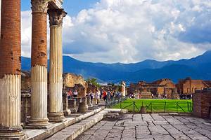
Pompeii
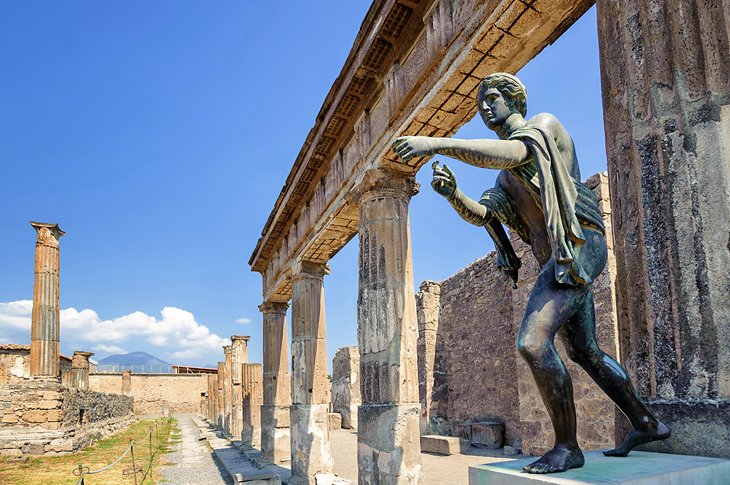
A visit to the National Archeological Museum in Naples will surely whet your appetite for seeing the city's almost more famous neighbor, Pompeii. Several centuries of excavations have uncovered homes, shops, temples, and public buildings of a prosperous city of 20,000 engulfed and frozen in time by the cataclysmic eruption of Vesuvius in AD 79.
An easy way to see this UNESCO World Heritage Site with an expert guide, and also hike to the summit of Mt. Vesuvius, is to take the Mt. Vesuvius and Pompeii Day Trip from Naples. The seven-hour tour includes a delicious Italian pizza lunch.
Herculaneum
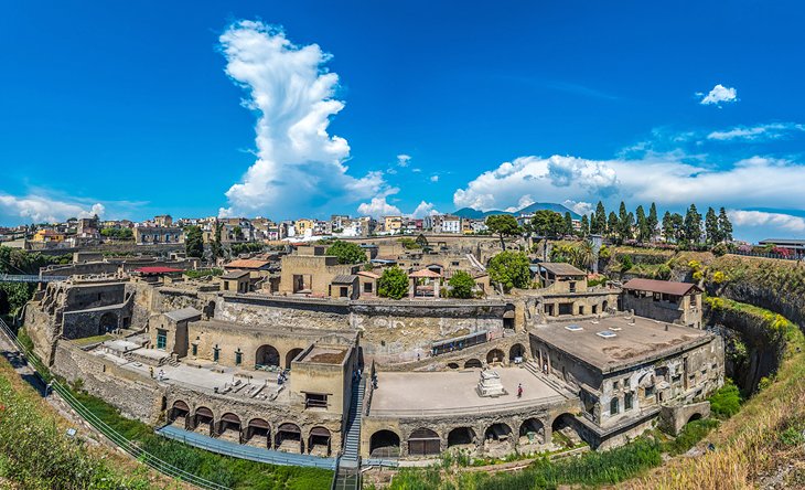
Unlike neighboring Pompeii, the Roman resort town of Herculaneum was engulfed by molten lava instead of ash in the AD 79 eruption of Mt. Vesuvius, and its buildings were supported by the lava as it rose in depth.
The difference had two results: organic materials were preserved in a dry airtight environment, and the cooled stone was so deep and hard that the site was protected from early plunder until modern techniques and sensibilities could preserve its treasures. What you see today gives an even more intimate view of Roman life than Pompeii.
You can visit both of these world-class attractions from Naples, on a Private Tour Day Trip Excursion to Herculaneum, Mt. Vesuvius, and Pompeii. Your expert guide will make sure you see the highlights of each archaeological site, and as an added bonus, you'll get to walk to the rim of the crater on Vesuvius.
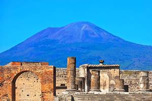
Vesuvius
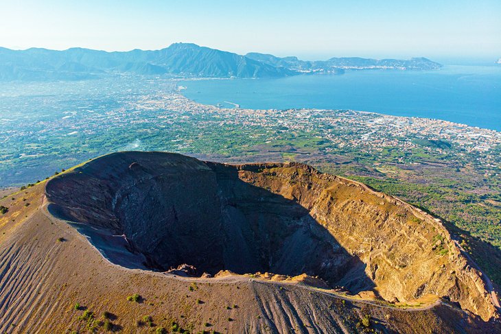
Rearing abruptly out of the plain, 15 kilometers southeast of Naples on the shores of the bay of Naples, Vesuvius is the only volcano on the European mainland that is still intermittently active. It is best known, of course, for the disastrous eruption in AD 79 that destroyed both Pompeii and Herculaneum. Its last major eruption was in 1944, and there have been signs of only mild activity since.
Drive or take a bus from Pompeii or Herculaneum to the Vesuvius National Park lot at about 1,000 meters altitude. Trails lead up the final 200 meters to the rim, which can be followed along its entire perimeter. As you would expect, the views are spectacular.
You can explore the volcano with a guide on the Vesuvius: Half Day Trip from Naples, a four-hour trip that includes hiking to the cone and learning about its history and geology.
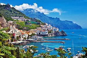
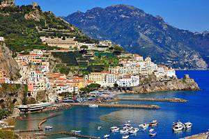
Amalfi Coast
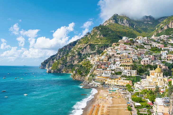
The southern coast of the Amalfi Peninsula, south of Naples, is among the most beautiful in all Europe, with colorful villages clinging to steep mountainsides that drop almost straight into the blue waters of the Mediterranean.
There are several ways to see this coast: by car, bus, boat, or organized tour. While of these a car gives you more freedom to stop and explore on your own (bus schedules make it difficult to spend any time in the towns), the road is narrow and demands 100 percent attention from the driver at all times.
The most flexible solution is the Private Tour: Sorrento, Positano, Amalfi, and Ravello Day Trip from Naples, where you can craft your own itinerary along this spectacular stretch of coast, with the help of your knowledgeable guide. You'll have plenty of time to explore some of the region's most charming towns in the comfort of a private chauffeur-driven car. Hotel pickup and drop-off are included.
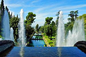
Caserta Palazzo Reale
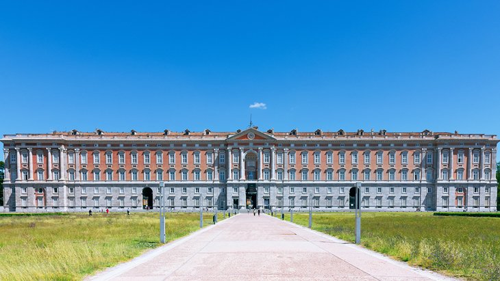
Opposite the station in Caserta is the former Royal Palace, a magnificent 1,200-room residence often compared to Versailles. It was built by Luigi Vanvitelli for King Charles III of Naples and Sicily, beginning in 1752, and today, its interior, well-preserved decoration, and furnishings form a museum of the Bourbon dynasty that ruled here from 1734 to 1860. Particularly fine are the Grand Staircase of 116 steps, the Cappella Reale, the Royal Apartments, and the theater.
In the Second World War, the Palace served as the headquarters of the Allied Middle East Command, and on April 29, 1945, the German armies in Italy signed the surrender document here. Behind it stretches a park with impressive fountains and the Grand Cascade. From the terrace beyond the English Garden, about a 45-minute walk north of the palace, are sweeping views.
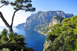
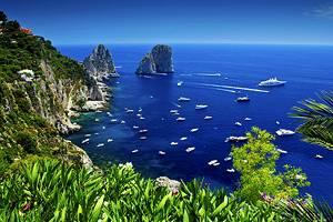
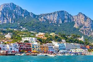
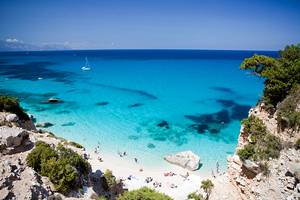
Capri
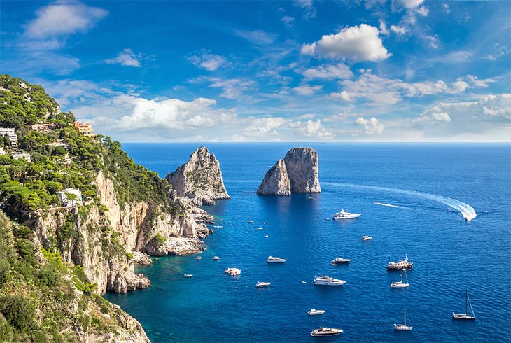
Regular ferries carry passengers from the Naples harbor across the bay to the island of Capri. It's a favorite day trip for locals, and the ferry from Naples is a good way for tourists who don't plan on visiting Sorrento to see this fabled island and its prime attraction, the Blue Grotto.
The full-day Capri and Blue Grotto Day Tour from Naples or Sorrento whisks you to this glamorous island via jetfoil. You'll see the striking azure water in the Blue Grotto, visit the beautiful towns of Anacapri and Capri, admire some of the island's fascinating rock formations, and explore the coastline by minibus.
- Read More: Top-Rated Tourist Attractions in Capri
Ischia
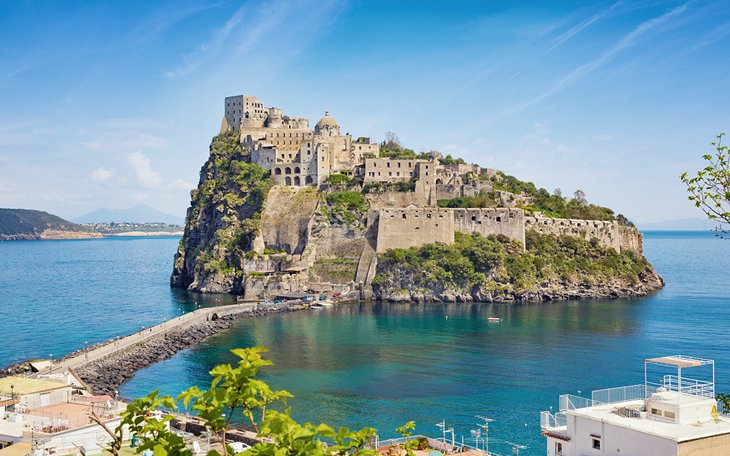
At the entrance to the Bay of Naples, the volcanic island of Ischia was known to the ancient Greeks and Romans, who were attracted by its hot springs and the luxuriant flora. Today, it's less crowded with day trippers than nearby smaller Capri, and has much nicer beaches.
The town of Ischia, on the northeast coast, is made up of Ischia Ponte, where the imposing Castello stands on a 91-meter rocky crag accessible by a stone causeway, and the busier spa and seaside resort of Ischia Porto. The island's oldest harbor here is a former crater lake.
From Forio, on the west coast, a beautiful road leads to the southern part of the island, past La Mortella, beautiful gardens created by Susana Walton and British composer Sir William Walton and well worth a stop. The southern shore is the quietest, where the village of Sant'Angelo sits picturesquely on the slopes of a promontory.
Frequent boats connect Ischia to Naples harbor and to the smaller island of Procida, almost too cute to be real, with its taffy-colored houses. Or you can go directly to Procida from Naples by hydrofoil on the Day Trip to Procida Island with Lunch tour, enjoying a full day on the island at your own pace, with lunch at a local restaurant.
Benevento and the Arch of Trajan
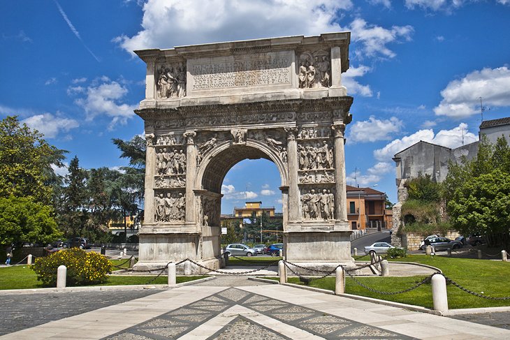
About 50 kilometers northeast of Naples, Benevento commands a beautiful setting on a flat-topped hill between two rivers, at the junction of the Via Appia with four other Roman roads. This position made it one of the most important towns in southern Italy, and for five centuries, it was the seat of powerful Lombard dukes.
It has a 14th-century castle and the remains of a Roman theater now used for opera performances, but its major tourist attraction is the magnificent Arco di Traiano (Arch of Trajan), also known as Porta Aurea, dedicated by the senate and people of Beneventum to the "best of princes" in AD 114, in anticipation of his return from the Parthian wars.
The arch, built of Greek marble, stands 15.5 meters high and is one of the finest of its kind. The entire arch, including the marble reliefs glorifying the emperor, is very well preserved.
Castellammare di Stabia
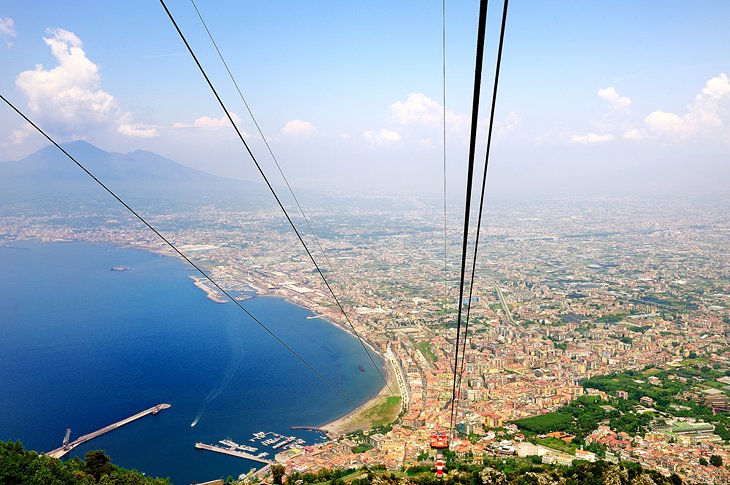
About 30 kilometers south of the city, on the Bay of Naples, Castellammare di Stabia is adjacent to the ancient city of Stabiae, destroyed by the AD 79 eruption of Vesuvius. You can visit the excavated Roman villas, which were very well preserved by the "rain" of volcanic ash that buried them. Frescoes and mosaics are intact, as is the swimming pool in its colonnaded atrium.
A cable car from the Castellammare Circumvesuviana station climbs Monte Faito, from whose summit there are walking trails and magnificent views of the Bay of Naples and Vesuvius.
Capua
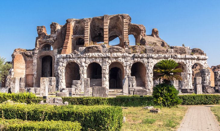
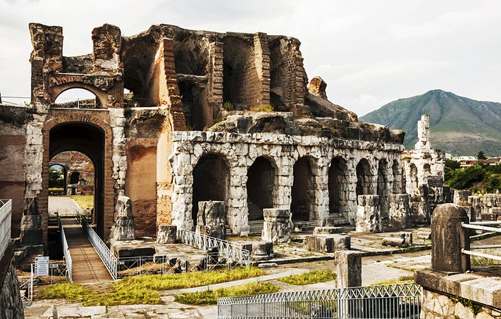
Modern Capua is built adjacent to the ancient city of Capua Vetere, destroyed in the ninth century. In the center of town, near the Volturno River, the cathedral's campanile and 11th-century forecourt with third-century columns survived after the building itself was destroyed in World War II. Nearby, the Campanian Provincial Museum is the region's most important archeological museum after the National Museum in Naples.
Outside of town is a Roman amphitheater, built under Augustus and restored by Hadrian, one of the largest remaining, with many of its subterranean passages intact. On the Via Appia, which connected the town to Rome, are two well-preserved Roman tombs.
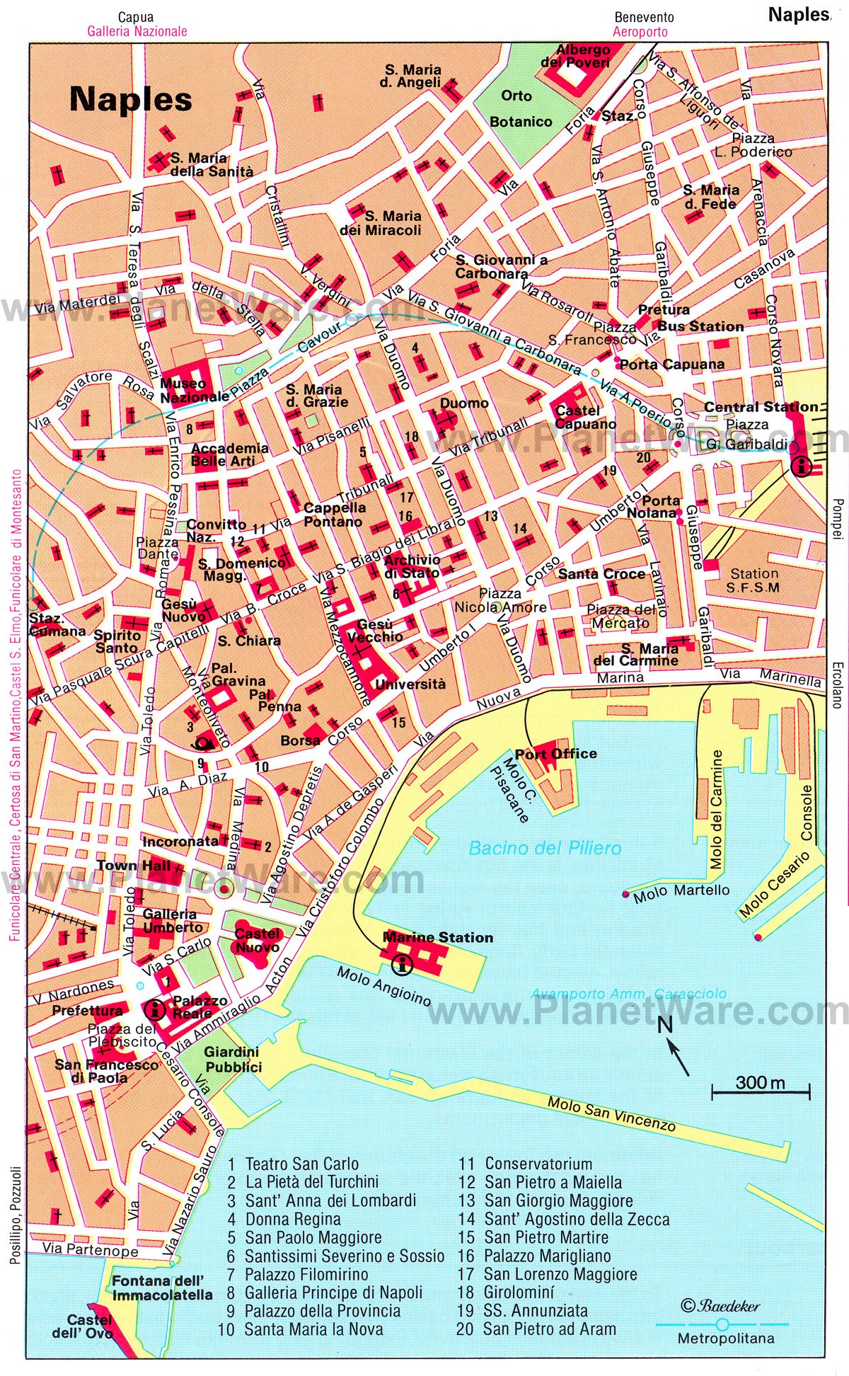
Map of Tourist Attractions in Naples & Easy Day Trips
Naples, Italy - Climate Chart
| Average minimum and maximum temperatures for Naples, Italy in °C | |||||||||||
| J | F | M | A | M | J | J | A | S | O | N | D |
| 13 4 | 13 4 | 15 6 | 18 8 | 23 12 | 26 16 | 29 18 | 30 18 | 26 15 | 22 12 | 17 8 | 14 5 |
| PlanetWare.com | |||||||||||
| Average monthly precipitation totals for Naples, Italy in mm. | |||||||||||
| 104 | 99 | 86 | 76 | 51 | 33 | 25 | 41 | 81 | 130 | 163 | 122 |
| Average minimum and maximum temperatures for Naples, Italy in °F | |||||||||||
| J | F | M | A | M | J | J | A | S | O | N | D |
| 54 38 | 55 39 | 59 42 | 64 46 | 72 53 | 79 60 | 84 64 | 85 64 | 79 59 | 71 52 | 62 45 | 56 41 |
| PlanetWare.com | |||||||||||
| Average monthly precipitation totals for Naples, Italy in inches. | |||||||||||
| 4.1 | 3.9 | 3.4 | 3.0 | 2.0 | 1.3 | 1.0 | 1.6 | 3.2 | 5.1 | 6.4 | 4.8 |
More Related Articles on PlanetWare.com
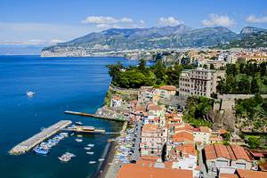
Where to Go near Naples: Surrounded by some of Italy's most popular places to visit, Naples makes a good starting point for seeing the tourist attractions in Sorrento and exploring the Amalfi Coast, as well as visiting Herculaneum and the dramatic ruins of Pompeii.
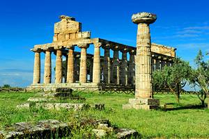
Exploring beyond Naples: South of the Amalfi Coast are the magnificent ruins of Paestum, the finest remains of Greek architecture on the Italian mainland. Or from Naples harbor, you can take a ferry to the fascinating island of Sardinia and its capital city of Cagliari.