19 Top-Rated Tourist Attractions in Mexico City
Author Meagan Drillinger spends months each year in Mexico, and visited Mexico City most recently in 2023.
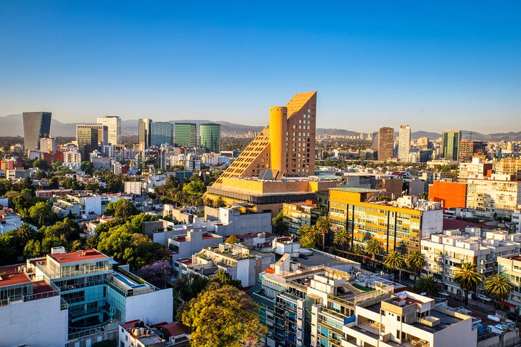
Mexico City is, in a word, magic. The capital of the country of Mexico, Mexico City (or Ciudad de Mexico) is a swirl of gorgeous architecture, art museums, fabulous restaurants, and hotels — all set on streets that drip with centuries of history.
The city sits at an altitude of more than 2,200 meters in the Anáhuac Valley, wreathed in mighty mountain ranges — just have a look at the two snowcapped volcanoes, Popocatépetl and Iztaccíhuatl, which stand guard in the distance.
Mexico City is one of the largest and most exciting cities in the world. Home to more than 21 million people, it's a thriving (sometimes chaotic) capital, home to the country's top tourist attractions, including the historic city center, more than 170 museums, theater, and even a few Aztec ruins.
Discover more things to do in this vibrant city with our list of the top attractions in Mexico City.
- 1. Zócalo: The Birthplace of the Constitution
- 2. The National Museum of Anthropology
- 3. Templo Mayor and the Great Pyramid of Tenochtitlán
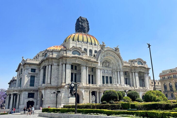
- 4. The Palace of Fine Arts
- 5. Mexico City Metropolitan Cathedral
- 6. The National Palace
- 7. Chapultepec Park
- 8. Paseo de la Reforma and the Angel of Independence
- 9. National History Museum
- 10. Coyoacán & the Frida Kahlo Museum
- 11. The Basilica of Our Lady of Guadalupe
- 12. Alameda Central
- 13. The Square of the Three Cultures and Santiago de Tlatelolco
- 14. The House of Tiles
- 15. Museo Mural Diego Rivera and Museo Rufino Tamayo
- 16. Museo Soumaya
- 17. Explore the Polanco Neighborhood
- 18. Visit Teotihuacan
- 19. Church of San Francisco
- Where to Stay in Mexico City for Sightseeing
- Tips and Tours: How to Make the Most of Your Visit to Mexico City
- Map of Tourist Attractions in Mexico City
- Mexico City, Mexico - Climate Chart
1. Zócalo: The Birthplace of the Constitution
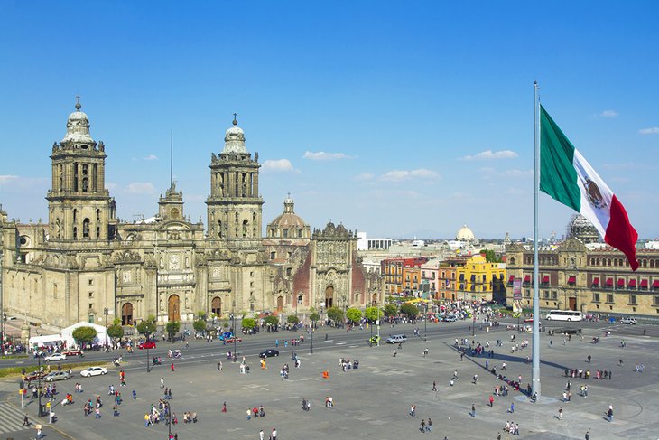
The beating heart of Mexico City is Zócalo — the Plaza de la Constitución (Constitution Square) — where the country's first constitution was proclaimed in 1813. Measuring some 240 meters in each direction, it's one of the world's largest squares and was laid out almost immediately after the conquest of the former Aztec city of Tenochtitlán on which it stands.
In the early colonial period, the square served a variety of purposes, including as a bullfighting arena and market, while today, it's used for festivals, parades, and demonstrations.
Dominated by three of the city's most visited tourist attractions — the National Palace, the Metropolitan Cathedral, and the Templo Mayor with its Aztec relics — Zócalo is the perfect place to begin exploring this historic city.
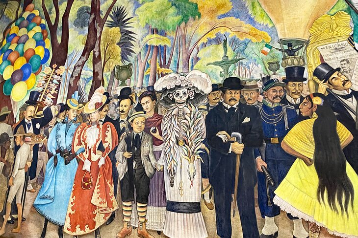
Hot Tip: A short stroll away from Zócalo, you can view three floors of murals by the famous artist Diego Rivera at the Secretaría de Educación Pública (education ministry). Entry is free.
2. The National Museum of Anthropology

One of the most important of its kind in the world, the National Museum of Anthropology lies in Chapultepec Park and is hard to miss due to the huge monolithic figure marking its entrance.
Built in 1964, this strikingly successful example of contemporary architecture is famous for its magnificent displays of old Indian art treasures, most notably in the Central Patio, part of which is roofed by a gigantic stone shelter supported by an 11-meter-tall column with waterfalls symbolizing the eternal cycle of life.
As spectacular as the building itself is its vast collection, which includes archaeological finds from extinct Indian cultures along with details of the lifestyles of contemporary Indian inhabitants of Mexico.
Other highlights include the National Library of Anthropology, founded by Lucas Alaman in 1831 and developed by Emperor Maximilian, which boasts more than 300,000 rare volumes.
Address: Av Paseo de la Reforma y Calzada Gandhi S/N, Chapultepec Polanco, 11560 Ciudad de México, CDMX, Mexico
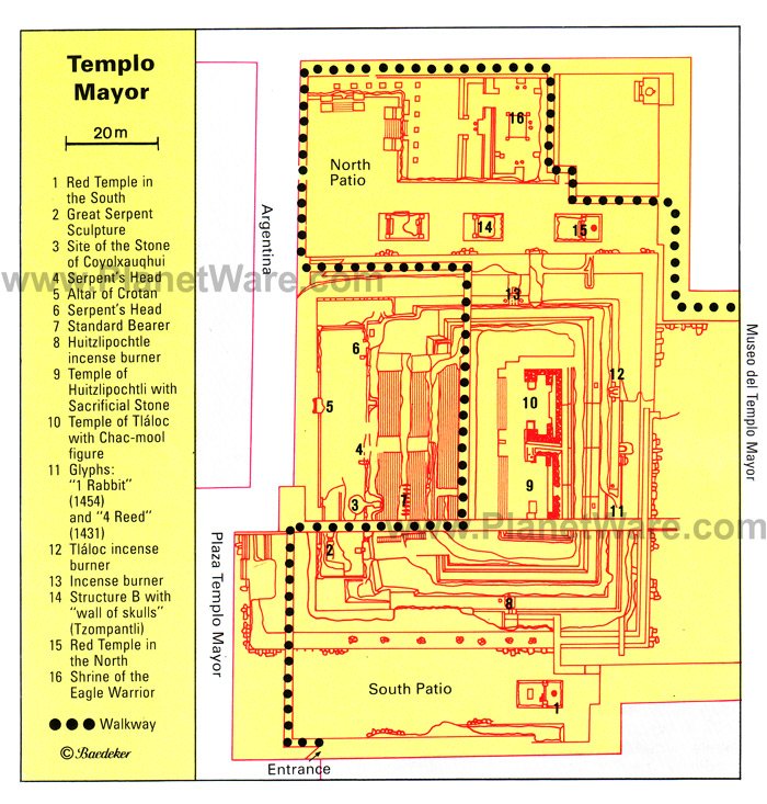
3. Templo Mayor and the Great Pyramid of Tenochtitlán
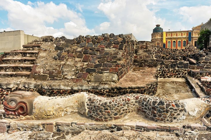
Despite the widespread destruction after the defeat of the Aztecs, a number of their important historic sites have been unearthed and put on display in recent years. The most important site is Templo Mayor, home to the remains of the Great Temple of Tenochtitlán, including the first relic discovered in 1978, a finely sculpted round disc more than three meters in diameter and weighing eight-and-a-half tons.
Further excavations — including the summit platform of an earlier pyramid with well-preserved temple walls, along with the skulls of sacrificial victims — indicate the temple site had been built over by the Aztecs and their predecessors 11 times.
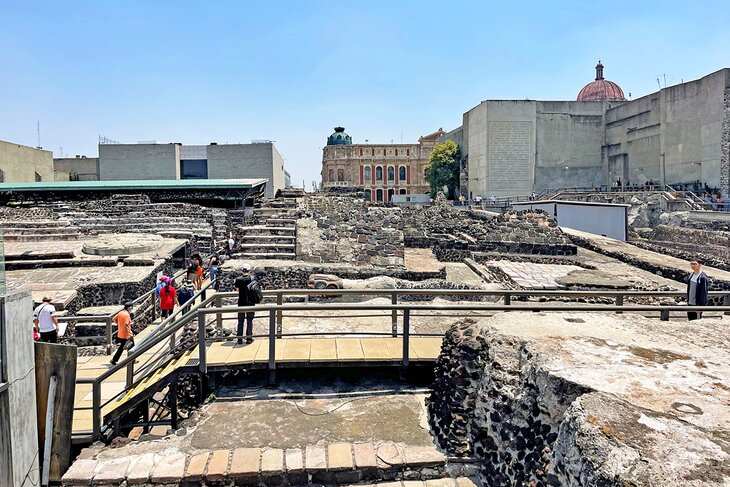
A highlight of a visit is a walkway past the precinct of the aristocratic "winged warriors," where remains of residences decorated with multi-colored reliefs have been unearthed, along with evidence of the original paintwork.
Hot Tip: The vast majority of relics and artifacts uncovered are housed in two museums: the Templo Mayor Museum built on the temple site, and the nearby National Museum of Anthropology, widely regarded as the most important museum in Mexico.
Address: Seminario 8, Centro Histórico, 06060 Ciudad de México, CDMX, Mexico
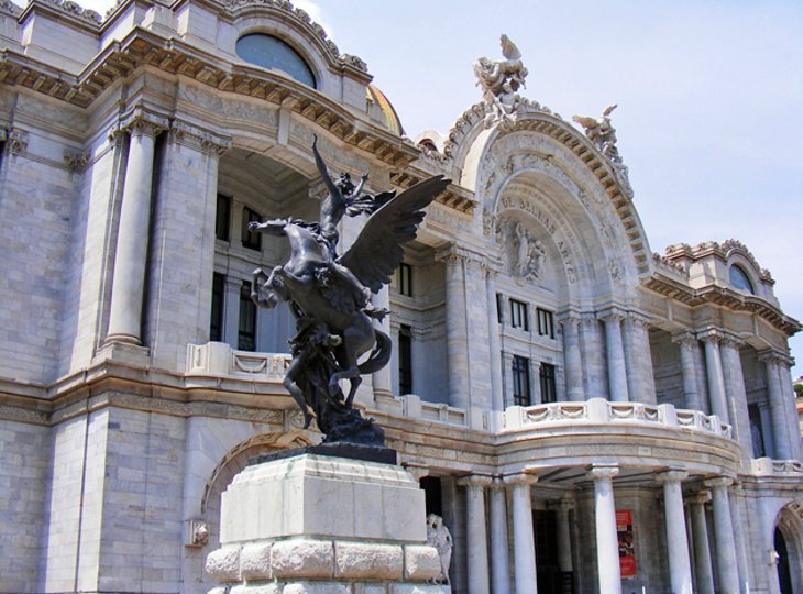
4. The Palace of Fine Arts

One of Mexico City's most important cultural landmarks, the Palace of Fine Arts (Palacio de Bellas Artes) is an architectural gem. Towering over the adjacent park, this massive marble building — designed by Italian architect Adamo Boari with Art Nouveau and Art Deco influences — was completed in 1934 and is so heavy that it has sunk more than four meters, despite attempts to lighten it by removing part of its huge dome.
The palace serves as an opera house and concert hall hosting a variety of traditional and international dance and operatic productions. But many visitors also come here to view the impressive murals adorning its interior by famous artists such as Diego Rivera, David Alfaro Siqueiros, and José Clemente.
On the 4th floor is the Museo Nacional de Arquitectura with rotating exhibits on contemporary architecture.
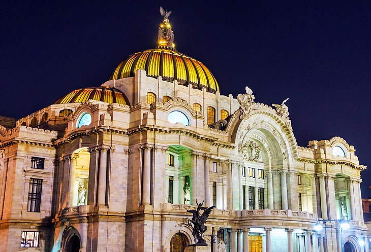
If you happen to be in town on Wednesday or Sunday, tickets to the Ballet Folklorico are a must. For nearly 60 years, this performance has brought the traditional costumes, dance, and music from all regions of Mexico to one stage for a performance that is beyond entertaining, colorful, and beautiful.
Hot Tip: If you're able to see a performance here, you'll also be rewarded with a chance to enjoy the theater's stunning interior décor, including its spectacular glass-mosaic curtain, made by Tiffany's of New York, depicting the Valley of Mexico and its two mighty volcanoes.
Address: Juárez, Centro Histórico, 06050 Ciudad de México, CDMX, Mexico
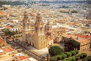
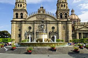
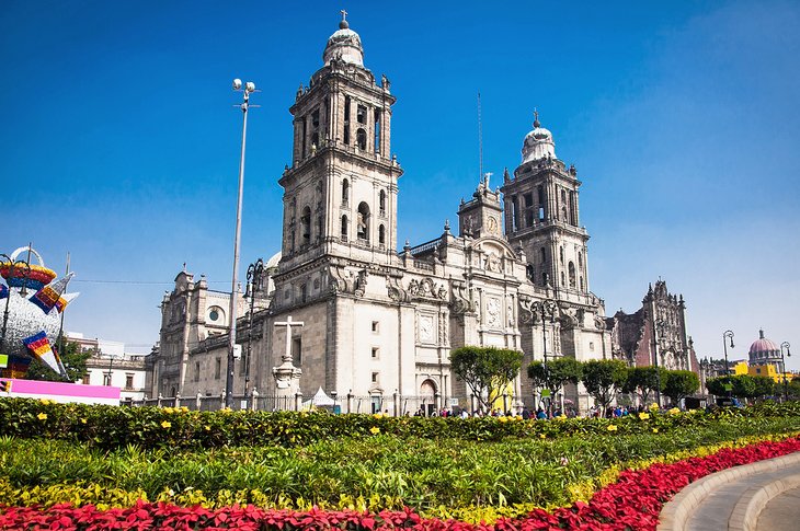
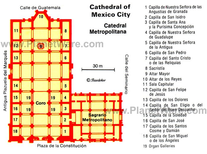
5. Mexico City Metropolitan Cathedral
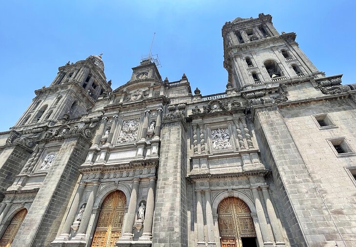
Dominating Zócalo Square, the massive Mexico City Metropolitan Cathedral (Catedral Metropolitana de la Asunción de María) is one of the oldest and largest churches in the Western Hemisphere. Built atop part of the old Aztec temple precinct, construction of this massive basalt and grey sandstone structure began in 1525 and extended over 250 years.
In spite of the two neoclassical towers and certain other features, the façade creates a predominantly Baroque impression with its massive twisted columns. Standout features are the bell towers added in 1793 and the statues of Faith, Hope, and Charity on the clock tower, dating from 1813.
The cathedral's interior also shows a mingling of styles, with particular highlights being the richly carved Altar of the Kings (Altar de los Reyes) from 1739, with its superb devotional painting of the Assumption (Asunción de María) to which the cathedral is dedicated.
Also of interest are a chapel containing the remains of Mexican Emperor Agustin de Iturbide, and the crypt with its tombs of many of the city's archbishops, among them Juan de Zumárraga, the great teacher of the Indians and the first incumbent of the see.
Address: Plaza de la Constitución S/N, Centro, 06000 Ciudad de México, CDMX, Mexico
6. The National Palace
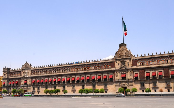
Occupying the east side of Mexico City's main square, Zócalo, the immense National Palace (Palacio Nacional), built of reddish tezontle stone and boasting a 200-meter-long façade, is the official residence of the president.
Built on top of an Aztec palace, it was the seat of the Spanish viceroys during the colonial period and has been much altered and enlarged over the years. One of the oldest and finest buildings in the city, it includes such notable features as the Freedom Bell, rung on September 15th, 1810, at the start of the War of Independence (it's rung on the anniversary of this event each year).
The palace boasts many handsome rooms laid out around its 14 courtyards, some accessible to visitors, the most notable being the arcaded Grand Courtyard with its fine frescoes depicting the country's rich history. Don't miss The History of Mexico mural by Diego Rivera, which adorns the grand staircase.
English-language guided tours explore a museum, a number of large halls, and the parliamentary chamber in which the Reform Constitution of 1857 was drawn up (it and the Constitution of 1917 are on display).
Other attractions here are the State Archives, with important historical documents, and the Biblioteca Miguel Lerdo de Tejada, one of the country's largest libraries.
Address: Plaza de la Constitución S/N, Centro, 06066 Ciudad de México, CDMX, Mexico
7. Chapultepec Park
Bosque de Chapultepec is Mexico City's principal park, and covering an area of more than four square kilometers, it is also its largest. Once a stronghold of the Toltecs, it was here in AD 1200 that the Aztecs settled, and according to legend, laid out a park in the early 15th century.
Over time, the hill became a summer residence of the Aztec rulers with water from its springs conveyed to the temple precinct in the capital by means of an aqueduct, the remains of which can still be seen in Avenida Chapultepec. Portraits of the Aztec rulers were carved on the slopes of the hill, remnants of which can still be seen.
These days, the park is popular for its lakes, sports facilities, botanic garden, and museums — you'll find both the National History Museum and the National Museum of Anthropology here — along with numerous fun events, including concerts and theatrical performances.
Also of interest is the Museum of Modern Art (Museo de Arte Moderno), which opened in 1964 and is important for its retrospective look at Mexican art before and during the colonial period and its collection of pictures and sculptures by Mexican artists of the 19th and 20th centuries.
The Chapultepec Zoo is also here with a surprising diversity of animals from around the world.
8. Paseo de la Reforma and the Angel of Independence
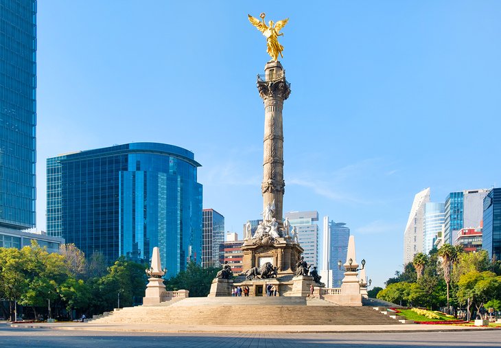
The principal east-west traffic artery of Mexico City, Paseo de la Reforma extends for 15 kilometers from Tlatelolco to the residential district of Las Lomas but is best known for the stretch from Avenida Benito Juárez to Chapultepec Park.
Here, this attractive boulevard widens to 60 meters with a pleasant green strip in the middle containing busts and monuments to numerous national heroes. While now largely known as a busy entertainment and shopping area, this magnificent avenue - laid out during the reign of Emperor Maximilian - is home to a number of important attractions, most notably the massive Independence Monument (Monumento a la Independencia), also known as "El Angel" for the figure of a winged goddess of victory standing atop its tall 36-meter column.
In addition to its fine statues of the heroes of the country's independence movement is the Mausoleum, with its many skulls of some of the country's most important historical figures.
On Sunday mornings, Paseo de la Reforma closes to cars to become a pedestrian and cycle-friendly thoroughfare. It's one of the best things to do for residents of all ages. You may even find a pop-up yoga class happening in the street.
Address: Paseo de la Reforma y Eje 2 PTE, Juárez, Cuauhtémoc, Ciudad de México, CDMX, Mexico
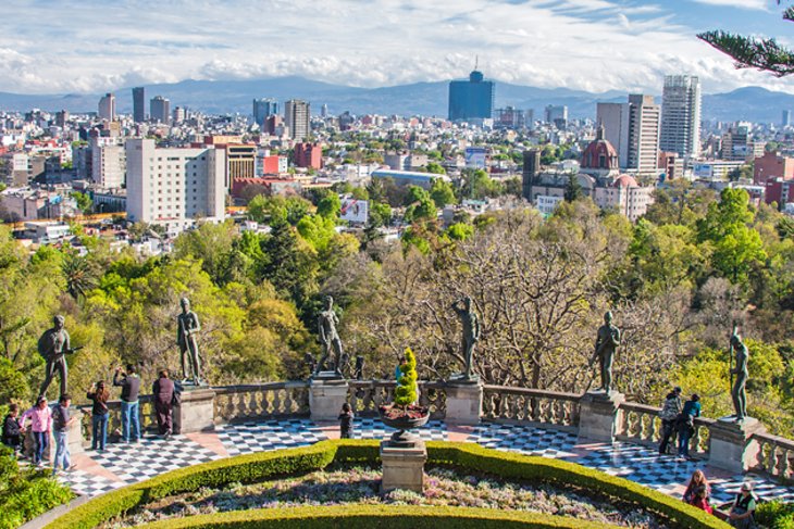
9. National History Museum
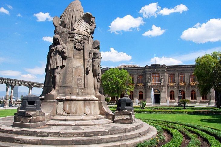
Another of Mexico City's world-class attractions is the National History Museum (Museo Nacional de Historia). Housed in the 18th-century Chapultepec Castle (Castillo de Chapultepec), on a site once occupied by Aztec buildings and later by a Spanish hermitage, the museum opened in 1944 and is home to an impressive collection of pre-Columbian material and reproductions of old manuscripts, as well as a vast range of exhibits illustrating the history of Mexico since the Spanish conquest.
Highlights include arms and armor, documents, maps, and plans of the Conquest period and its immediate aftermath; ceramics, clothing, jewelry, and coins from three centuries; relics and souvenirs of the struggle for independence and the revolutionary wars; portraits of leading figures in Mexican history; and a number of state carriages, including those used by Benito Juárez and Emperor Maximilian.
Also of interest are the apartments occupied by Maximilian and Charlotte, decorated in neoclassical style and containing furniture brought from Europe. The castle also offers beautiful views over the city.
Address: Castilla de Chapultepec 1a Sección, Mexico City, CDMX, Mexico
10. Coyoacán & the Frida Kahlo Museum
Laced with atmospheric cobblestone streets, Coyoacán is one of Mexico City's oldest neighborhoods. Take time to stroll around the maze of laneways here and explore the hidden plazas, colonial-style mansions, and art-filled old churches like San Juan Bautista.
You can also sample exotic fruits and vegetables at the markets. One of the top tourist attractions in the town is the Frida Kahlo Museum in La Casa Azul (The Blue House), where the famous Mexican artist was born and where she frequently returned throughout her life. Here, you can view some of her most important paintings, as well as works by her famous husband, the mural artist Diego Rivera, and personal items from the couple's life. Note that it's best to purchase tickets in advance.
An easy way to see all the highlights of Coyoacán is on the full-day Mexico City Super Saver Tour. This 11-hour excursion begins with a guided tour through the neighborhood, including a visit to the Frida Kahlo Museum and North America's oldest university, as well as a boat tour along the canals of the UNESCO-listed ecological reserve, Xochimilco.
While you're in Coyoacan you can also visit the Museo Casa de Leon Trotsky. This is the house where Leon Trotsky, the exiled Russian politician, spent the final years of his life before he was assassinated.
Address: The Frida Kahlo Museum, Londres 247, Del Carmen, Coyoacán, 04100 Ciudad de México, CDMX, Mexico
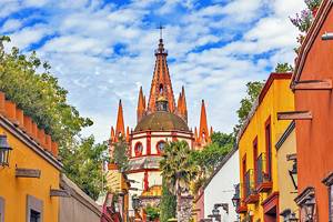
11. The Basilica of Our Lady of Guadalupe
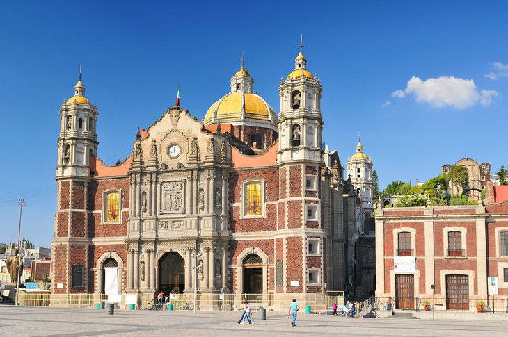
Said to have attracted its first pilgrims when it opened in 1531, the Roman Catholic Basilica of Our Lady of Guadalupe (Basílica de Nuestra Señora de Guadalupe) attracts millions of visitors and worshipers each year, particularly during the Feast Day each December 12th.
Built adjacent to the hill where the Virgin Mary is said to have appeared, the site consists of a complex of buildings overlooking a broad public square adorned with a number of interesting modern sculptures, including a large concrete cross with a unique clock and chime.
Highlights include a splendid altarpiece dedicated to Mary in the 16th-century Old Basilica, and the new Basilica de Guadalupe, built in 1976, and notable for its distinctive modern curved appearance.
Address: Plaza de las Américas 1, Villa de Guadalupe, 07050 Ciudad de México, CDMX, Mexico
12. Alameda Central
Alameda Central, a shady and beautifully kept park with many splendid fountains and sculptures, was laid out in 1592 on the site of a once-busy Aztec market. It remains a bustling location to this day, especially at Christmas, when it is beautifully illuminated and decorated. Next to the park is the stunning Palacio de Bellas Artes, which hosts music and theatrical performances as well as important art exhibitions.
Address: Av Hidalgo S/N, Cuauhtémoc, Centro, 06010 Ciudad de México
13. The Square of the Three Cultures and Santiago de Tlatelolco
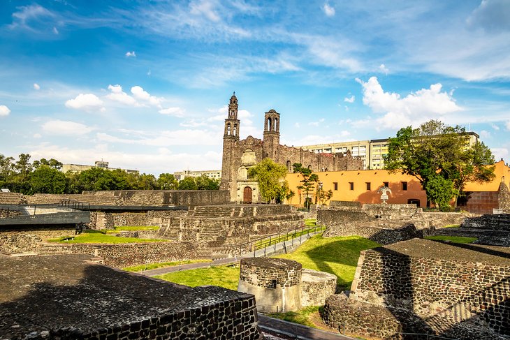
Another of Mexico City's important historic squares is the Square of the Three Cultures (Plaza de las Tres Culturas). The square occupies the site of the main square of the Pre-Columbian town of Tlatelolco and the scene of the last desperate stand by the Aztecs in 1521 - an event remembered by a memorial tablet.
It takes its name from its interesting mix of buildings from three different periods: Aztec pyramids and temples, a Spanish church, and modern tower blocks. In addition to the principal pyramid, other Aztec remains include a number of smaller pyramids, platforms, staircases, walls, and altars, as well as a "tzompantli," a wall of skulls and fine reliefs of Aztec calendar signs.
The square is also home to a rather sobering memorial museum, Memorial 68, commemorating the tragic murder of some 250 protesting students by government forces in 1968.
Also of note is the Baroque church of Santiago de Tlatelolco, built in the early 17th century on the site of a small chapel from 1535 that belonged to the Franciscan convent of Santiago. Adjoining the church is one of the old convent buildings, formerly the Colegio Imperial de Santa Cruz, in which the Franciscans taught the gifted sons of the Aztec nobility (one of the most notable teachers was Bernardino de Sahagún, the great chronicler of the history of New Spain).
14. The House of Tiles
Opposite the picturesque Church of San Francisco is the spectacular House of Tiles (Casa de los Azulejos). It was originally built in 1596 and boasts a façade decorated by the Conde del Valle de Orizaba 150 years later, with exquisite blue and white tiles from Puebla.
It became even more famous after artist José Clemente Orozco painted murals on the walls of the staircase in 1925. The House of Tiles is now a restaurant and an evocative venue to dine al fresco in the building's spectacular courtyard, surrounded by what is one very large work of art.
Hot Tip: Be sure to check out the large photo marking the spot where Emiliano Zapata and Pancho Villa dined together on arrival in Mexico City.
Address: Av Francisco I. Madero 4, Centro, 06500 Ciudad de México, CDMX, Mexico
15. Museo Mural Diego Rivera and Museo Rufino Tamayo
A short walk from the National Museum of Anthropology is Museo Rufino Tamayo, named after Rufino Tamayo (1900-91), one of Mexico's most famous painters. Notable for its unusual interior, the gallery opened in 1981 and, in addition to Tamayo's artwork it also displays his own extensive collection of several hundred works by contemporary artists, including prints, paintings, sculptures, and wall hangings.
Another important art facility worth visiting is Museo Mural Diego Rivera named after one of the country's leading artists whose most famous painting - Dream of a Sunday Afternoon in Alameda Park - in which he caricatured some of Mexico's historical figures, is on display here after years of being banned by the state (Rivera had originally called it Dios no existe, or God does not exist).
Address: Paseo de la Reforma 51, Bosque de Chapultepec, 11580 Ciudad de México, CDMX, Mexico
16. Museo Soumaya
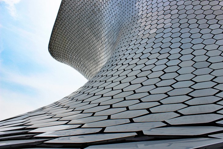
A trip to Mexico City would be incomplete without a visit to the Museo Soumaya. This futuristic, architectural mind-meld was founded by Carlos Slim, one of the wealthiest men in the world, who named it for his deceased wife, Soumaya. Inside is more than 66,000 pieces of art that span 3,000 years, from sculptures from Mesoamerica right up to works from Tintoretto and Salvador Dali.
The non-profit cultural icon originally was housed in the Plaza Loreto of San Angel until 2011. It was moved to a new building in Plaza Carso in Nuevo Polanco, designed by Mexican architect Fernando Romero. The silver, reflective building spans 170,000 square feet of space and is a design feat in itself, pinched at the center like an hourglass, but angular like the hull of a ship.
But the real masterpieces continue inside. The majority of art is from the 15th to 20th centuries, though there is a substantial collection of indigenous Mexican art. Slim is the owner of the world's largest private collection of Auguste Rodin's art, as well, and the museum has the largest collection of casts of his sculptures outside of France.
Address: Blvd. Miguel de Cervantes Saavedra, Granada, Miguel Hidalgo, 11529 Ciudad de México, CDMX, Mexico
17. Explore the Polanco Neighborhood
When it comes to the original "in vogue" destination in Mexico City, Polanco is at the top of the list. This swanky, glitzy, expensive neighborhood has always been about high style, fine dining, and fabulous hotels. Within the neighborhood are countless shops and restaurants, as well as a corner of Chapultepec Park.
If you're looking for one of the most up-scale destinations in Latin America, Polanco certainly takes the lead. The neighborhood's main artery is the Avenida Presidente Masaryk, which is often likened to the 5th Avenue of Mexico City. It's easy to see why when you see art gallery after art gallery, fine dining after fine dining, shopping malls, and gorgeous hotels.
Start at the Antara Fashion Hall, where you'll find all the brand names, from Hugo Boss to Carolina Herrera. You can also visit the Siqueiros Public Art Room, where muralist David Siquieros hosts workshops, talks, conferences, and exhibitions. You can also pop into Chapultepec Park for a lovely little afternoon picnic.
In the evening, snag a reservation at the legendary Pujol restaurant before heading to the Telcel Theatre for a Spanish-language performance of one of the Broadway greats.
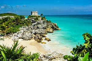
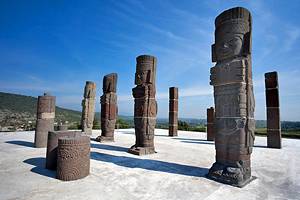
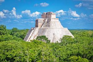
18. Visit Teotihuacan
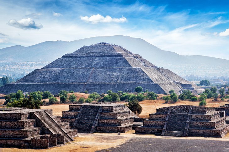
Perhaps one of the most culturally and historically significant sites in Mexico City, the archeological zone at Teotihuacan tells so much of the story of the birth of Mexico.
The ancient site, a UNESCO World Heritage Site, was settled around 400 BCE and rose to be one of the most powerful cities in the region. It is still a mystery how the city came to be, but several theories exist surrounding earlier tribes that could have contributed to the city's growth. In the 15th century, the Aztecs claimed the city, naming it Teotihuacan.
Today what remains of Teotihuacan's eight square miles are 2,000 single-story apartment compounds, pyramids, temples, and palaces. It is known for its iconic Pyramid of the Sun and Pyramid of the Moon. The Pyramid of the Sun is the largest structure in Teotihuacan and faces west, measuring roughly 720 feet by 760 feet.
Priests at Teotihuacan were known to practice human and animal sacrifice. In fact, archeologists discovered 18 sacrificial victims buried around some of the temples, including the Pyramid of the Moon.
Today visitors can explore Teotihuacan on their own or as part of a tour. The archeological site is just 30 miles outside Mexico City.
19. Church of San Francisco
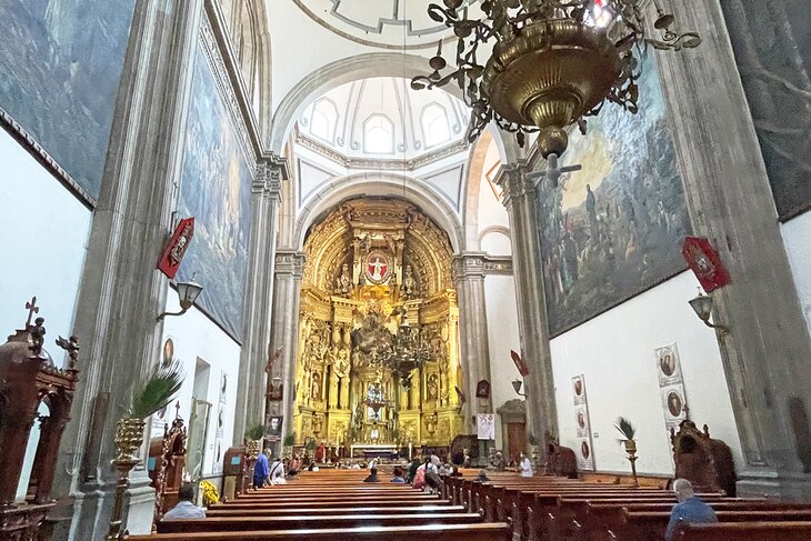
Along Madero Street (the street that leads to the Zocalo), you'll find the stunning Church of San Francisco. It's directly across the street from The House of Tiles. This beautiful, historic convent was once at the heart of a sprawling church and monastery complex. Today, all that remains is the church.
Still, what remains is a spectacular site to behold. Just look at the beautifully carved doorway, which dates back to the 18th century. The reddish bricks that you see to the right are stones that were used originally to build the Aztec buildings that once made up Moctezuma's private zoo.
When first constructed, the church was one of the earliest and most powerful Franciscan monasteries in the city. It also held the first 12 Franciscan friars who arrived in what was then "New Spain."
The church that exists today is actually the third to be built here and dates back to the early 18th century. Services are still held today.
Address: Av Francisco I. Madero 7, Centro Histórico de la Cdad. de México, Centro, Cuauhtémoc, 06000 Ciudad de México, CDMX, Mexico
Where to Stay in Mexico City for Sightseeing
If you're traveling to Mexico City for the first time, the best area to stay is in the historic city center (Centro Histórico de la Ciudad). This UNESCO World Heritage Site centers around the Zócalo, with the Metropolitan Cathedral, National Palace, and Templo Mayor.
The affluent Polanco neighborhood, also makes a great base, with its luxury hotels and upscale restaurants. It's about a 30-minute drive from the Centro Histórico, but near all the attractions of Chapultepec Park and the famous shopping street, Paseo de la Reforma. Here are some highly rated hotels in these convenient locations:
Luxury Hotels:
- If you like grand historic hotels, the Gran Hotel Ciudad de Mexico in the Centro Histórico has affordable rates and an unbeatable location, within walking distance of the major historical attractions and with a rooftop terrace overlooking the Zócalo.
- A dazzling stained-glass ceiling caps the elegant lobby. In the quieter Polanco neighborhood, a short stroll from Chapultepec Park, JW Marriott Hotel Mexico City features a full-service spa and outdoor pool.
- Near Polanco and just a short walk to the Chapultepec Castle, the St. Regis overlooks Paseo de la Reforma and occupies a sleek modern building with contemporary decor to match.
Mid-Range Hotels:
- A 10-minute walk to Zócalo, near restaurants and shops, the boutique Historico Central, in a beautifully restored 18th-century building, blends history with modern decor and thoughtful added touches such as artisan soaps.
- Also in a historic building is the Hampton Inn & Suites Mexico City - Centro Historico, featuring a gorgeous stained-glass ceiling. It lies within walking distance of the Zócalo, Alameda Cathedral, and the Palacio de Bellas Artes.
- The name says it all when it comes to location at the Zocalo Central, in an elegant building dating from the late 19th century. Some rooms score a bird's-eye view over this famous square.
Budget Hotels:
- Near the Palacio de Bellas Artes, a 20-minute walk from the Centro Histórico, the good-value One Ciudad De Mexico Alameda has clean, compact rooms and free breakfast.
- A few blocks from Paseo de la Reforma, Hotel Bristol is popular for its friendly service and comfortable rooms, while the modern City Express Plus Reforma El Angel is a short cab ride away from the historical center.
Tips and Tours: How to Make the Most of Your Visit to Mexico City
Taking an organized tour is the best way to see Mexico City's top attractions and a convenient way to enjoy day trips to surrounding sites. Guided tours save you time navigating the city's traffic-clogged streets, plus you can learn about the history and culture of the city. These sightseeing tours all include expert guides, entrance fees, and round-trip transportation.
- Coyoacán, National University, and Frida Kahlo Museum: Mexico City's art, history, and nature are covered on the full-day Mexico City Super Saver Tour. This 11-hour excursion begins with a tour through the cobblestone streets of the evocative colonial city of Coyoacán, including a visit to the Frida Kahlo Museum and National University. Top off your city sightseeing adventure with a relaxing boat tour along the canals of the UNESCO-listed ecological reserve Xochimilco.
- Teotihuacan Pyramids: On the eight-hour Early Morning Teotihuacan Pyramids Tour, you'll be one of the first visitors to gain access to this UNESCO-listed archaeological park. Better still, a private archaeologist guides you through the top sites, including the Palace of Quetzalpapalotl, Sun Pyramid, and Moon Pyramid. After exploring these ancient temples, the tour takes you to an obsidian workshop to see local artisans at work.
- Iztaccihuatl Volcano: Avid hikers can enjoy spectacular views of Popocatepetl and the Valley of Mexico on the Iztaccihuatl Volcano Hiking Tour from Mexico City. This 12-hour tour includes a hike up the intermediate trail of this dormant volcano, stopping short of the 5,230-meter summit to admire the panorama.
Map of Tourist Attractions in Mexico City
Mexico City, Mexico - Climate Chart
| Average minimum and maximum temperatures for Mexico City, Mexico in °C | |||||||||||
| J | F | M | A | M | J | J | A | S | O | N | D |
| 21 7 | 23 7 | 25 10 | 27 11 | 27 12 | 25 13 | 23 12 | 23 12 | 23 12 | 23 10 | 22 8 | 21 7 |
| PlanetWare.com | |||||||||||
| Average monthly precipitation totals for Mexico City, Mexico in mm. | |||||||||||
| 10 | 10 | 13 | 28 | 58 | 158 | 183 | 173 | 145 | 61 | 5 | 8 |
| Average minimum and maximum temperatures for Mexico City, Mexico in °F | |||||||||||
| J | F | M | A | M | J | J | A | S | O | N | D |
| 70 43 | 73 45 | 77 49 | 79 52 | 79 54 | 76 54 | 73 53 | 74 53 | 73 53 | 72 50 | 72 47 | 70 45 |
| PlanetWare.com | |||||||||||
| Average monthly precipitation totals for Mexico City, Mexico in inches. | |||||||||||
| 0.4 | 0.4 | 0.5 | 1.1 | 2.3 | 6.2 | 7.2 | 6.8 | 5.7 | 2.4 | 0.2 | 0.3 |