22 Top-Rated Attractions & Things to Do in Cairo
Cairo is one of the world's great megacities.
For historical sightseeing, there are few cities that can compete with Cairo, but Egypt's capital offers many more things to do than just museums and mosques.
As beautiful and as rich in historic finery as it is confounding and an assault on your senses to first-time visitors, Cairo tends to be a city that travelers love and hate in equal measures.
Its sheer noise, pollution, and traffic can make a first visit here difficult to navigate, but Egypt's capital has so much to offer travelers that look beyond its problems.
Full of vigor, Cairo is the best place to visit in the country to get a feel for modern Egyptian street life. No trip to Egypt is complete without a stay in the city Arabs call Umm al-Dunya (The Mother of the World).
The main tourist attraction everyone is here to see is the Giza Pyramids on the city's doorstep, but the city itself is crammed with major monuments that span centuries of history.
There are so many things to do in Cairo that you'll only be able to cover a sliver on one trip.
To help focus your visit and plan your time use our list of the top attractions in Cairo.
- 1. Marvel at the Pyramids of Giza
- 2. See One of the World's Great Collections in the Egyptian Museum
- 3. Admire Al-Azhar Mosque
- 4. Explore Coptic History in Old Cairo (Coptic Cairo)
- 5. Spend Time Exploring Saqqara & Dahshur
- 6. View the Royal Mummies at NMEC
- 7. Shop amid the Maze of Khan el-Khalili
- 8. Get Views across the City at the Citadel
- 9. Admire Mamluk Architecture in the Sultan Hassan Mosque
- 10. Visit the Museum of Islamic Art
- 11. Climb Up to the Roof of Bab Zuweila
- 12. Stroll down Al-Muizz li-Din Allah Street
- 13. Visit the Ibn Tulun Mosque
- 14. Relax amid the Greenery of Al-Azhar Park
- 15. Explore the Nile Island District of Zamalek
- 16. Visit Cairo's Remaining Nilometer
- 17. See the Sumptuous Interior of Manyal Palace
- 18. Day Trip to Al-Fayoum
- 19. Mosque of Al-Hakim
- 20. Explore the Architecture of Downtown Cairo
- 21. Day Trip to Tanis
- 22. Ancient Heliopolis and El-Matariya
- Where to Stay in Cairo for Sightseeing
- Tips and Tours: How to Make the Most of Your Visit to Cairo
- Map of Attractions & Things to Do in Cairo
- Cairo, Egypt - Climate Chart
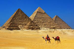
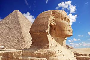
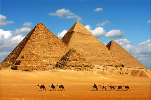
1. Marvel at the Pyramids of Giza

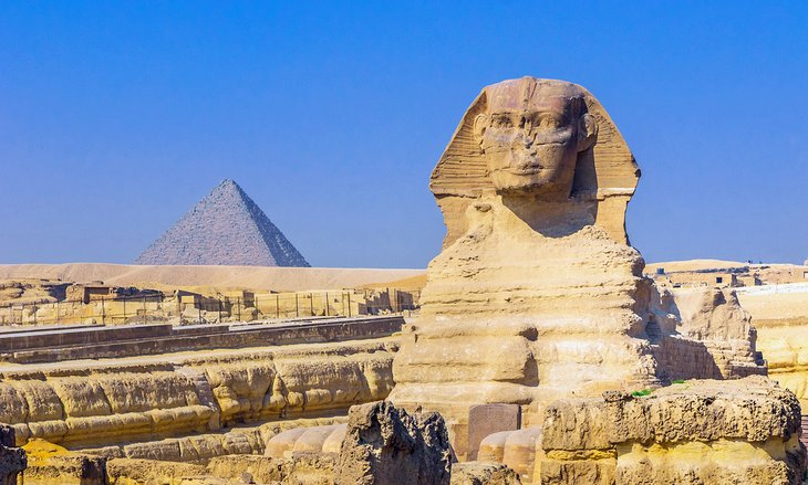
The Pyramids of Giza are Cairo's number one half-day trip and the top thing to do on everyone's itinerary.
Right on the edge of the city, on the Giza Plateau, these fourth dynasty funerary temples have been wowing travelers for centuries and continue to be one of Egypt's major highlights.
Despite the heat, the dust, and the tourist hustle, you can't miss a trip here.
The Pyramid of Cheops (also called the Great Pyramid or Pyramid of Khufu) is the largest pyramid of the Giza group, and its interior of narrow passages can be explored, although there isn't much to see, except a plain tomb chamber with an empty sarcophagus.
Farther south on the plateau is the Pyramid of Chephren (also known as the Pyramid of Khefre), with an internal tunnel area, which can be entered, and the smaller Pyramid of Mycerinus (Pyramid of Menkaure).
Guarding these mortuary temples is the lion-bodied and pharaoh-faced Sphinx; one of the ancient world's iconic monuments.
The Giza Plateau is set to welcome another attraction when the Grand Egyptian Museum (GEM) is finally finished.
When opened, it will be the biggest museum in the world devoted to exhibiting the antiquities of a single civilization, displaying a wealth of Ancient Egypt's artifacts, many of which have never been seen by the public before.
The Solar Boat (one of the ceremonial solar barques that were unearthed near the Giza Pyramids), which used to be displayed in a museum directly behind the Great Pyramid, has recently been moved to the GEM in readiness for the opening.
After a stop-start construction, beset with financial difficulties, the museum opening date has been set for 2024.
The pyramid plateau is on the edge of Giza's suburban sprawl, roughly 13 kilometers southwest of the central city.
Most people arrive by taxi, but it's also accessible by an easier-than-you-think combo of taking the metro to Giza and then hopping on a local minibus that drops you outside the entrance.
As the area around the Pyramids of Giza is quite sprawling, many travelers elect to see the area by tour, often incorporating a camel or horse ride.
A good option for first-time visitors is the Private Half-Day Trip to the Giza Pyramids with Camel-Riding. This includes pickup and drop-off at your hotel, a guide, lunch, and 25 minutes on a camel.
Address: Al-Ahram Street, Giza
2. See One of the World's Great Collections in the Egyptian Museum
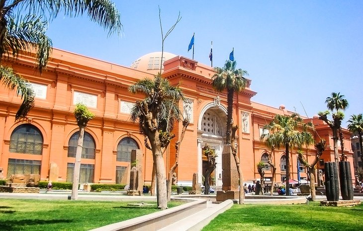
The absolutely staggering collection of antiquities displayed in Cairo's Egyptian Museum makes it one of the world's great museums. You would need a lifetime to properly see everything on show.
The museum was founded in 1857 by French Egyptologist August Mariette and moved to its current home – in the distinctive powder-pink mansion in Downtown Cairo – in 1897.
Yes, the collection is poorly labeled and not well set out due to limits of space (and only a fraction of its total holdings are actually on display).
It also currently suffers with some empty cases due to artifacts having already been transferred to the as yet unopened new Grand Egyptian Museum (GEM), but you still can't help being impressed by the sheer majesty of the exhibits.
When the GEM opens, this iconic building is slated to still be used as a museum, but it is uncertain which collections it will hold.
The museum's major displays, including the Tutankhamun Galleries, which will form the highlight exhibition within the new GEM, are all definitely being moved.
Meanwhile, in April 2020, the Egyptian Museum's Royal Mummies Collection was transferred to the National Museum of Egyptian Civilizations (NMEC) to further share out the vast amount of Egypt's Pharaonic riches between Cairo's museums.
If you're pressed for time, make a beeline straight for the Tutankhamun Galleries.
The treasures displayed here were all found in the tomb of Tutankhamun, son-in-law and successor of Amenophis IV (later Akhenaten), who died at the age of 18.
The tomb, discovered by Howard Carter in the Valley of the Kings in 1922, contained the largest and richest assemblage of grave goods ever found intact in an Egyptian tomb.
Highlights include Tutankhamun's death mask and sarcophagi (Room 3), the pharaoh's lion throne (Room 35), and his fascinating wardrobe collection (Room 9).
Afterwards, don't miss a wander through the Egyptian jewelry collection (Room 4) which contains more bling than you'll ever see again in one lifetime.
The Egyptian Museum sits right beside Midan Tahrir, the central square of Downtown Cairo.
The easiest way to arrive here is to take the Cairo Metro to Sadat station (on Midan Tahrir) and follow the exit signs to the museum.
Location: Midan al-Tahrir, Downtown
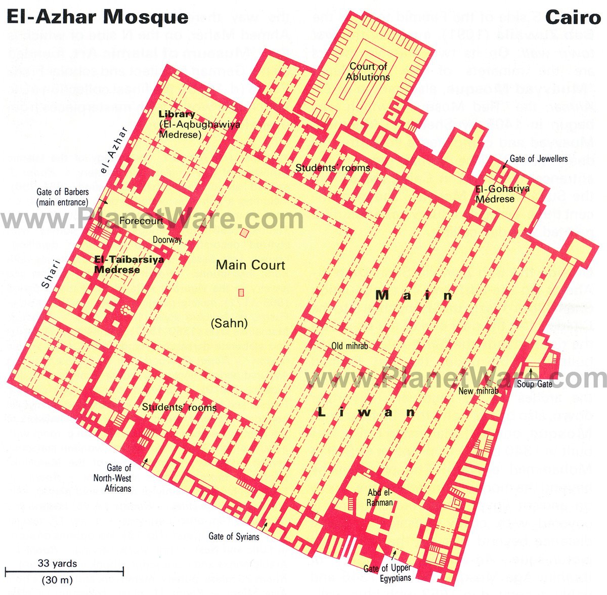
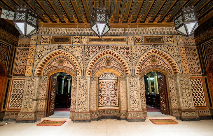
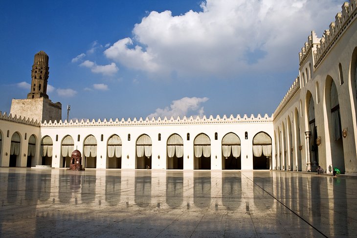
3. Admire Al-Azhar Mosque
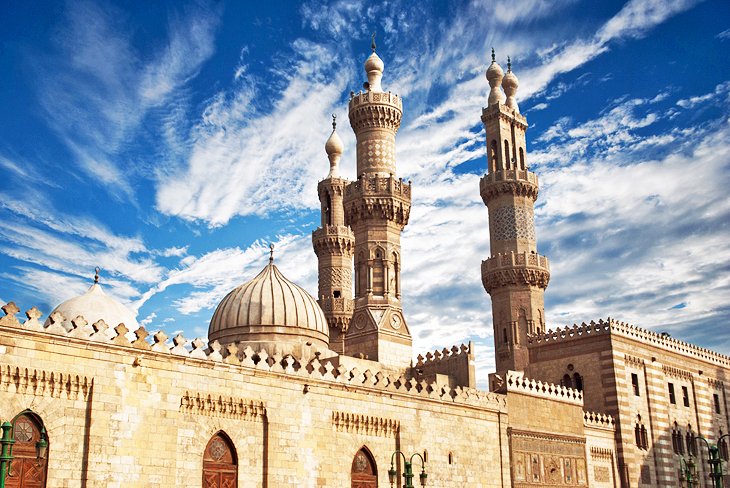
Al-Azhar Mosque is the finest building of Cairo's Fatimid era and one of the city's earliest surviving mosques, completed in 972 CE.
It's also one of the world's oldest universities - Caliph El-Aziz bestowed it with the status of university in 988 CE (the other university vying for "oldest" status is in Fes) and today, Al-Azhar University is still the leading theological center of the Islamic world.
The main entrance is the Gate of the Barbers on the northwest side of the building, adjoining the neo-Arab facade built by Abbas II.
Leave your shoes at the entrance and walk into the central courtyard. To your right is the El-Taibarsiya Medrese which has a mihrab (prayer niche) dating from 1309.
From the central courtyard, you get the best views of the mosque's five minarets, which cap the building.
Across the courtyard is the main prayer hall, spanning a vast 3,000 square meters. The front half is part of the original building, while the rear half was added by Abd el-Rahman.
Al-Azhar Mosque is right in the heart of the Islamic Cairo district and easy to reach by taxi.
Al-Azhar Street runs east from Midan Ataba in the downtown area right to the square where the mosque sits.
Address: Al-Azhar Street, Historic Cairo District
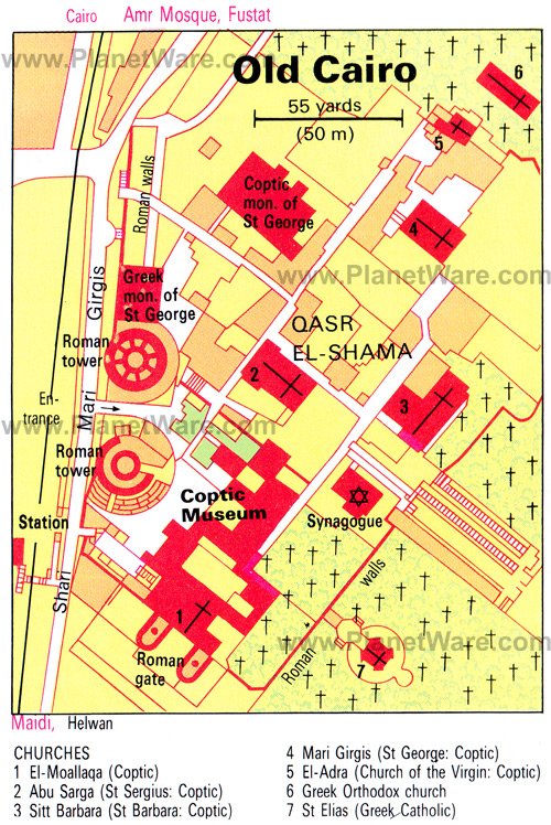
4. Explore Coptic History in Old Cairo (Coptic Cairo)
This small church-filled cluster of twisty laneways lies within the walls of Old Babylon, where the Roman Emperor Trajan first built a fortress along the Nile.
Parts of the Roman towers still preside over the main street.
The Coptic Museum here contains a wealth of information on Egypt's early Christian period and is home to one of Egypt's finest collections of Coptic art.
Next door, the 9th-century Hanging Church contains some beautiful examples of Coptic architecture. Founded in the 4th century, the church was originally built over the Roman gate towers (hence the name) and was substantially rebuilt during the 9th century.
For many Christian travelers though, the real highlight of a visit to this district is the Church of St. Sergius and Bacchus where local legend says the Virgin Mary, baby Jesus, and family sheltered during King Herod's massacre of male babies.
Farther into the quarter, you come to the Ben Ezra Synagogue which is said to be built near the spot where the baby Moses was found in the reeds.
Just outside the quarter, you can also visit the Mosque of Amr Ibn al-As; the first mosque built in Egypt.
Coptic Cairo is easiest reached by taking the Cairo Metro to Mar Girgis station.
Address: Sharia Mar Girgis, Mar Girgis
5. Spend Time Exploring Saqqara & Dahshur
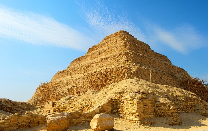
The vast necropolis of Saqqara and the nearby site of Dahshur are home to the "other pyramids," and a day trip out here is just as rewarding as a trip to Giza's pyramids. The sites are roughly 30 kilometers south of Cairo.
The Step Pyramid is Saqqara's most popular tourist attraction, but the entire area is littered with gorgeously painted tombs, which are well worth spending a few hours exploring.
Of particular note, don't miss the Serapeum, where the mummies of the sacred Apis bulls were interred, and the Mastaba of Ti, with its colorful and highly detailed painted walls.
Saqqara is so large, and its history as a burial site so vast, that excavations here continue to unearth finds that make headline grabbing news worldwide.
Just down the road are Dahshur's Red Pyramid and Bent Pyramid which shouldn't be missed. Expect even the shortest itinerary here to take at least half a day.
- Read More: Exploring Saqqara: A Visitor's Guide
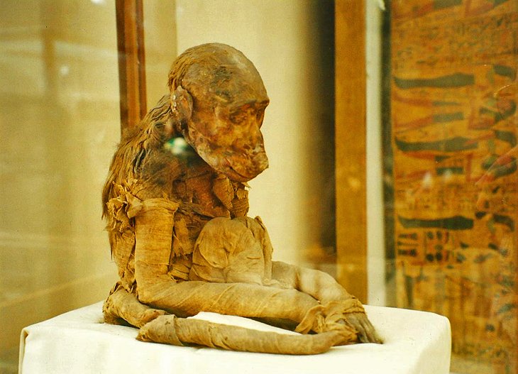
6. View the Royal Mummies at NMEC
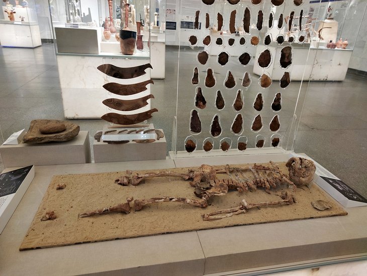
Unlike many of Cairo's other major museums, which all concentrate their exhibits on one specific era, the National Museum of Egyptian Civilizations (NMEC) is dedicated to telling the entire story of Egypt's human history under one roof.
The museum partially opened in 2017 and has been slowly building up its exhibits. Its star attraction arrived in April 2020, when the Royal Mummies Collection found its new permanent home here.
Although the museum's full collection is in no way yet complete, this is where you now come to view Egypt's most famous Pharaonic mummies.
Ramses II and III, Hatshepsut, Amenhotep I, and Seti I and II are among the hugely familiar names of 22 mummies that are displayed in a specially designed Royal Mummies Gallery.
NMEC is in Fustat and is easily combined with a visit to Old Cairo (Coptic Cairo). The museum is a straightforward three-kilometer walk from Coptic Cairo's churches, or a short taxi ride.
Address: Al Fustat Street, Fustat
7. Shop amid the Maze of Khan el-Khalili
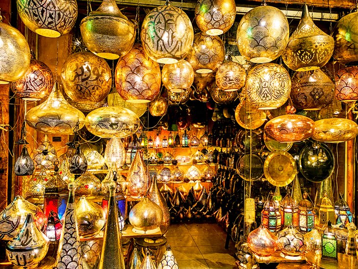
Khan el-Khalili is one of the world's great shopping experiences.
This souq (bazaar) is a labyrinthine collection of skinny alleyways established as a shopping district in 1400 CE, which still rings with the clang of metal workers and silversmiths.
The main streets have long ago given themselves over completely to the tourist trade (with plenty of cheap papyrus pictures and plastic pyramids on display), but divert off the main drag into the surrounding alleyways, and the tiny stores and cluttered workshops are some of the best places to visit to pick up traditional products in Egypt.
Here, you'll find everything from antiques and gorgeous metal lampshades to locally woven textiles.

While here, stop in at Cairo's most famous coffee shop, Fishawis, where syrupy Arabic coffee and sweet tea are dished out to tourists and local merchants alike at a rapid-fire pace.
For shoppers, the main souq road is Al-Muski Street (called Gawhar al-Qaid Street at its eastern end).
The gold and silver workshops mostly congregate just north of this street's intersection with Al-Muizz Li-Din Allah Street, while the spice market section is just to the south.
The market is hemmed in on its eastern side by the Sayyidna el-Husein Mosque, built in 1792 to honor the Prophet Muhammad's grandson.
The easiest entry to the Khan el-Khalili area is from Al-Azhar Street, directly across the road from Al-Azhar Mosque.
8. Get Views across the City at the Citadel
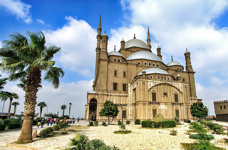
In a commanding location at the foot of the Mokattam Hills, Cairo's citadel was built by Saladin in 1176.
The original structure he laid out has long disappeared except for the eastern outer walls, but a legacy of rulers has made their own additions here.
The Mosque of Muhammad Ali is the most famous monument and the main reason for visiting. Nicknamed the "Alabaster Mosque," its white stone and tall, disproportionately slender minarets are one of Cairo's great landmarks.
The other big reason to come up here is the views across the city; head to the Gawhara Terrace for the best panorama in town.
Just to the northeast of the Muhammad Ali Mosque is the El-Nasir Mosque, built in 1318-35 by Mohammed el-Nasir.
A collection of rather half-hearted museums (the Police Museum, National Military Museum, and Carriage Museum) take up some of the other buildings on site and are more worthwhile viewing for the architecture of the actual buildings rather than the exhibits themselves.
You can walk to the citadel area from Bab Zuweila, if you're feeling energetic, by heading along Khayyamiyya Street. The walk takes about 30 minutes.
Address: Midan Salah-ad-Din, Historic Cairo District

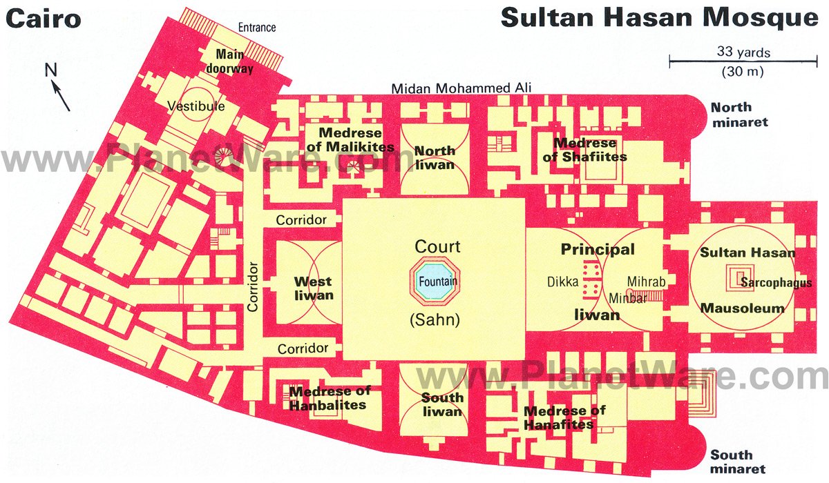
9. Admire Mamluk Architecture in the Sultan Hassan Mosque
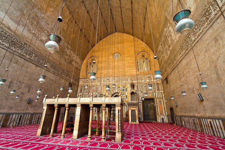
One of the finest examples of Mamluk architecture in the world, Sultan Hassan Mosque is a vision of Islamic artistry with an abundance of stalactite detailing and intricate arabesque features.
It was built in 1356-63 for the Sultan Hassan el-Nasir.
The massive main doorway at the north corner is almost 26 meters high, and the minaret at the south corner is the tallest in Cairo at 81.5 meters.
The main doorway leads into a domed vestibule, beyond which are a small antechamber and a corridor leading into the ornate open court centered around an ablution fountain.
From here, an iron door leads into the sultan's mausoleum where the stalactitic pendentives of the original dome still survive. In the center of the chamber is the sultan's simple sarcophagus.
Directly facing the Sultan Hassan Mosque is the El-Rifai Mosque, built in 1912 to house the tomb of Khedive Ismail and constructed to replicate its older next door neighbor.
The ex-Shah of Iran, Mohammed Reza Pahlavi (1919-1980), is also buried here.
Both mosques prominently sit on Midan Salah ad-Din, directly below Cairo's Citadel.
Address: Midan Salah-ad-Din, Historic Cairo District
10. Visit the Museum of Islamic Art
Cairo's Museum of Islamic Art holds one of the most important collections of Middle Eastern artistry in the world.
Severe damage sustained from a car-bomb attack in 2014 resulted in this museum shutting its doors to the public for years but thankfully it has now been reopened.
Ottoman tile work, Ayyubid ceramics, frescoes, delicately patterned wood-inlay, coinage, carved marble tombstones, and jewel-toned carpets, among other items are all on display.
Definitely spend some time perusing the illuminated Qurans and the exhibits of richly decorative ceramics, glassware, and metalware.
Then move on to admire the heavily ornate jewelry collection and the rooms devoted to Astronomy and other sciences, where you'll find highly detailed astrolabes and other equipment.
A visit here is a journey through the breadth and wealth of Islamic heritage.
The museum sits on the edge of the Historic Cairo district, so it's a good place to either begin or end a visit to the neighborhood. It's within easy walking distance (once you've crossed a hideously busy main road) to Bab Zuweila.
Address: Midan Bab Al Khalq, Historic Cairo District
11. Climb Up to the Roof of Bab Zuweila
Of all the Historic Cairo district's gates, Bab Zuweila is the most interesting.
You can climb to the top of this medieval-era relic (built in the 11th century) for some amazing rooftop views over the entire neighborhood.
The gate itself has two minarets and is the last southern gate of the old town still standing.
Right next door is the red-and-white stonework of the Sheikh al-Mu'ayyad Mosque, and a few steps farther away are the fascinating artisan stalls of the Street of the Tentmakers, where Egypt's bright fabric used for weddings and other special occasions is sold in bulk.
Address: Al-Motaz li-Din Allah Street, Historic Cairo District
12. Stroll down Al-Muizz li-Din Allah Street
The northern section of Al-Muizz li-Din Allah Street is rimmed by fine Mamluk buildings, which have been painstakingly restored to their former glory.
The Madrassa of as-Salih Ayyub, built in 1247, is a showcase of the tranquil simplicity of Islamic architecture.
Directly across the road from the madrassa is the drop-dead gorgeous Madrassa of Qalaun, rightly considered one of the Mamluk period's greatest architectural triumphs.
It was completed in 1293 by Qalaun's son, Muhammad al-Nasir, and has an interior packed to the brim with intricate tile work, fine marble, mother-of-pearl mosaics, and stained-glass windows. Qalaun's madrassa also functioned as a hospital when it first opened.
A little farther north is the younger (built in 1309) Madrassa of an-Nasr Mohammed with plenty of ornate detailing to admire, before you come to the fabulous Egyptian Textile Museum with a collection that spans the Pharaonic era right up to the Islamic period.
Address: Al-Muizz li-Din Allah Street, Historic Cairo District
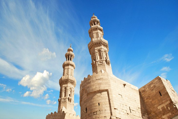
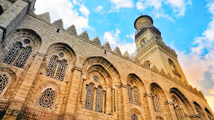
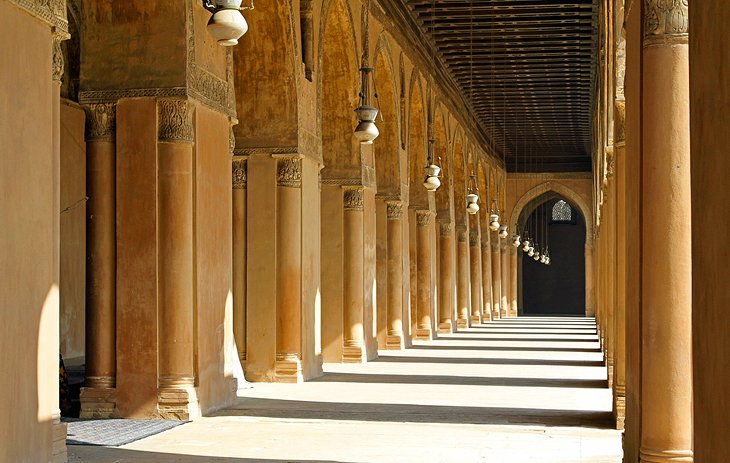
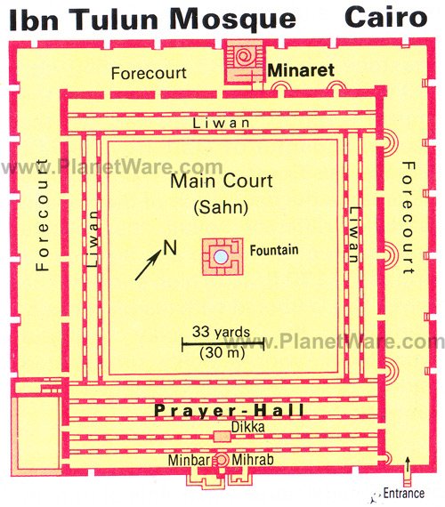
13. Visit the Ibn Tulun Mosque
The second oldest mosque still standing in Cairo, Ibn Tulun Mosque, was built between 876 and 879 CE by the Abbasid governor Ahmed Ibn Tulun.
At the time it was built, it was the largest mosque in existence.
The main court's colonnades have plentiful surviving fragments of intricate frieze work on display and open onto a series of narrow-fronted halls.
The main prayer hall (on the southern side of the court) still holds onto fragments of its older decoration of carved stucco and wood, and the mihrab here has remnants of its original gold mosaic decoration.
On the mosque's northern side is the 40-meter-high minaret with a fine horseshoe arch over the entrance and a spiral staircase swirling through the interior. It is modeled on the minarets of the Great Mosque of Samarra on the Tigris.
If you climb the 173 steps up to its upper platform there are superb views extending over the sea of houses to the north, and to the Mokattam Hills in the east.
It's an easy stroll from the Sultan Hassan Mosque to the Ibn Tulun Mosque walking straight down Al-Saliba Street.
Address: Al-Saliba Street, Historic Cairo District
14. Relax amid the Greenery of Al-Azhar Park
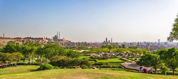
Built over what was essentially a medieval rubbish dump, Al-Azhar Park is the green lungs of the Historic Cairo district.
It was opened in 2005 and provides a much needed respite to the overcrowded chaos of Cairo's street hustle.
Inside, the gloriously manicured gardens are a lovely place for an evening stroll, especially as the views over the entire old city are gorgeous from here at sunset.
There are also a couple of restaurants on-site, so it's the perfect spot to put your feet up after a long day of sightseeing.
If you come on the weekend, the park is packed full of local families escaping the surrounding roar of traffic that cocoons the rest of Cairo.
Al-Azhar Park is most easily visited by taking a taxi, but if you're already in the Historic Cairo district and it's not too hot, you can turn east onto Darb al-Ahmar Street from Bab Zuweila and walk to the lower park entrance.
Address: Salah Salem Street, Historic Cairo District
15. Explore the Nile Island District of Zamalek
The Nile island of Gezira is home to the district of Zamalek and the majority of Cairo's arty boutiques and hipster restaurants.
Dating from the mid 19th century, the entire area has a distinctly European feel to its architecture with wide boulevards rimmed by trees and splendidly ornate Belle Époque mansions (many of which are now home to various embassies).
Zamalek is Cairo's top dining destination, but there are also a clutch of art galleries to explore.
The Museum of Modern Egyptian Art in the Gezira Fair Grounds, has a fine collection of 20th-century Egyptian art, including works by Mahmoud Said and Mahmoud Mukhtar.
Nearby, opposite Cairo Opera House, is the recently reopened Mahmoud Mukhtar Museum, which holds a small collection of the famous Egyptian sculptor's work.
Even if you're not specifically into art, check out the Aisha Fahmy Palace just off Sharia 26th July in Zamalek. This 1907 mansion has been finely restored to its original glory, and its rococo interiors are just as much a reason to visit as the rotating art exhibitions it now hosts.
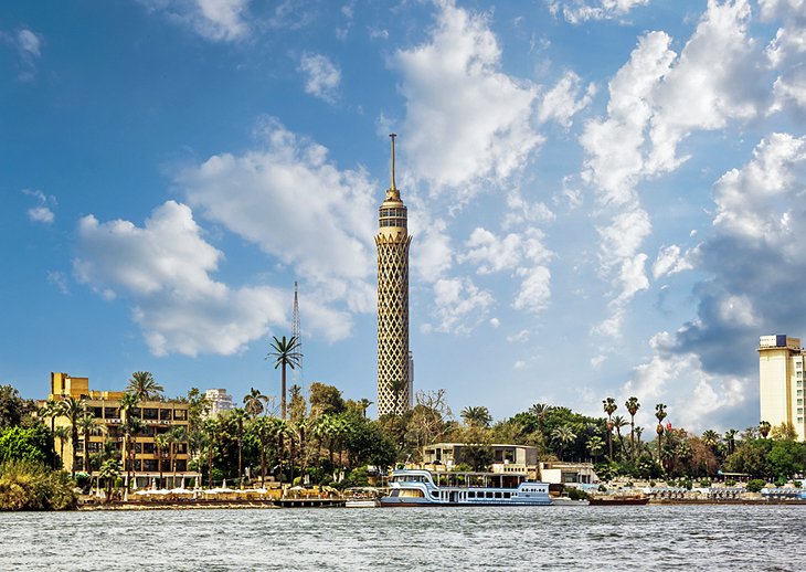
Much of the southern section of Gezira is taken up by the exclusive tennis courts and riding stables of the Gezira Sports Club, but towering above all the lush greenery is the 187-meter-high Cairo Tower, built in 1961 by President Nasser. A trip up the observation deck at sunset to see dusk settle over the city is a must.
16. Visit Cairo's Remaining Nilometer
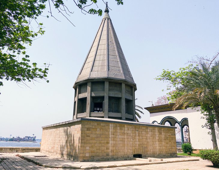
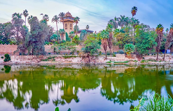
Lovely Roda Island - just south of Gezira Island - is home to Monastirli Palace, once the residence of an Ottoman pasha.
Inside the palace gardens, right at the island's southern tip, is Cairo's Nilometer, which was used to measure the ebb and flow of the Nile and predict the annual flood heights.
Unlike the Nilometers you'll see in Upper Egypt (such as the surviving Nilometer on Elephantine Island in Aswan), this one is a much later construction, built in CE 861.
Also in the palace grounds is the small Umm Khalthum Museum, which celebrates the life of Egypt's famed diva.
Umm Khalthum (1898-1975) is the Arab world's beloved songstress, and you'll hear her music everywhere you go in Egypt, blasted out onto the street from ahwas (traditional coffeehouses) and on the stereo of nearly every taxi.
Inside, the museum holds a collection of the singer's possessions, including her fabulously sequined stage costumes, and there's an interesting black and white documentary on her life (with English subtitles).
Outside the palace, Roda Island's streets are fun to wander and still have some dilapidated mansion architecture of the early 20th century.
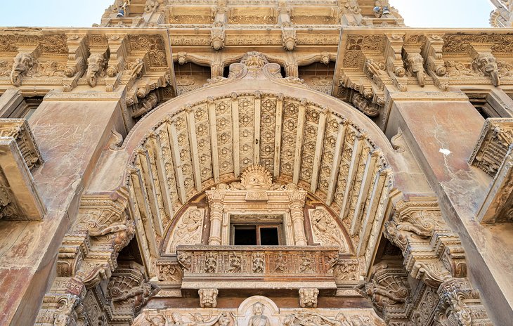
17. See the Sumptuous Interior of Manyal Palace
The north end of Roda island holds the gorgeously ornate Manyal Palace.
After an extensive restoration, which took several years, it has re-opened to the public.
The buildings here are an eccentric riot of styles that cherry-pick influences from both traditional Arabic and palatial European designs, resulting in an over-the-top, lavish symphony of interiors.
Check out the Reception Palace, where guests were hosted, with its elaborate wood ceilings, and then the Residential Palace with its Rococo flourishes, Ottoman-style tile work, and oil paintings.
The Throne Palace, decked out in gold, is the real highlight here, though.
The complex was built in the early 20th century by the uncle of King Farouk. It's set within lush green gardens on the shore of the island.
18. Day Trip to Al-Fayoum
The Al-Fayoum depression, 112 kilometers south of Cairo, is a wonderful day out from the city, with plenty of gobsmacking natural beauty and a handful of excellent historic sites all within a two-hour drive.
Lake Qarun and Wadi Rayyan are the main attractions for wilderness lovers, with plentiful birdlife on display, including flamingos.
If you want to stay overnight, the artist village of Tunis (where some of Egypt's best pottery can be purchased) is the destination most visitors choose.
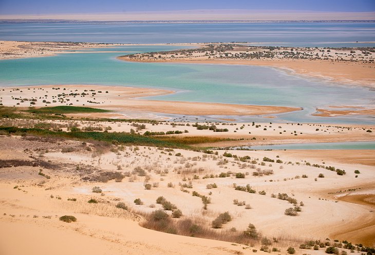
Fayoum's historic tourist attractions include the ruins of Medinet Madi, with its temple dating from the Middle Kingdom, and a clutch of small pyramids, the best being the Pyramid of Meidum and the Pyramid of Hawara.
The sight not to miss while in Fayoum, though, is the UNESCO-listed desert valley of Wadi Al-Hittan, where you can view the 40 million year old basilosaurus and dorodontus (pre-historic whales) skeletons that were unearthed here.
19. Mosque of Al-Hakim
Caliph Al-Hakim is one of the most fascinating rulers of Egypt.
This Fatimid leader was renowned for his terrifying rule over the land, which included frequent murders of his royal household staff; nightly patrols of the streets of his city, dressed incognito on a donkey to make sure his subjects were behaving themselves; and issuing bizarre rulings across the country (such as banning the eating of the Egyptian mallow-leaf, called molokheya, because only he wanted to be able to consume it).
His mosque, finished in 1013 CE, has functioned over the centuries as a madrassa, Crusader fortress, and psychiatric hospital and was completely restored in the 1980s.
The minarets here are the most interesting architectural elements. They were originally round, and their present square casing and domed top sections (resembling an Arab incense burner) date from their rebuilding after Cairo's 1303 earthquake.
The mosque sits in between two of the historic district's most important gates. Bab el-Futuh (Gate of Conquests) on the mosque's western side and Bab el-Nasr (Gate of Victory) to the east are similar in form to ancient Roman town gates and were both built in 1087.
You can walk between Al-Azhar Mosque and the Mosque of Al-Hakim by following Al-Mu'izz li-Din Allah Street all the way north.
Address: Al-Galal Street, Historic Cairo District
20. Explore the Architecture of Downtown Cairo
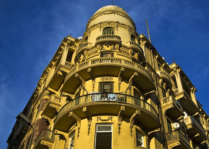
If you want to capture a sense of late 19th century Cairo, when the city was nicknamed the "Paris of the East," take a stroll through the downtown district with your gaze diverted up at the car-exhaust blackened architecture rather than on the bedlam at street level.
The entire area is chock-a-block stuffed with gorgeous but crumbling Belle Époque buildings, which must have looked staggeringly glamorous when they were first built.
Some of the finest buildings from this era, which also have recently cleaned facades, are around Midan Talaat Harb.
On the western edge of Downtown, on Al-Gumhuriya Street, is 19th century Abdin Palace, once the home of Egypt's last khedives.
Today, the former private apartments of the king are open as a museum and contain a bizarre collection of pictures, tapestries, and gifts that have been given to Egypt's presidents by visiting dignitaries.
Downtown Cairo is easily navigated on foot – if you don't mind dodging traffic as you cross the roads.
21. Day Trip to Tanis
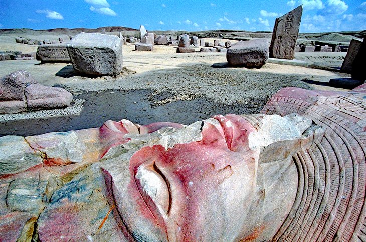
The remains of ancient Tanis, capital of the Tanite kings of the 21st and 22nd dynasties, lie in the northeast of the Nile Delta region, still partly buried under the ridge of the hills.
Tanis is probably most well-known as the lost city where Indiana Jones found the Ark of the Covenant in the classic film Raiders of the Lost Ark.
The movie's storyline has nothing to do with the real archaeological site, though Tanis was indeed "lost" for centuries until archaeological work here in 1939 finally managed to name this site as the city.
The excavated remains haven't been reconstructed as at other Ancient Egypt sites but are full of interest for the archaeologically inclined.
The temple remains mostly lie in ruins, with huge chunks of masonry and statuary scattered in place, while the royal necropolis with its empty tombs (the vast haul of jewelry treasures found here is now housed in its own room at the Egyptian Museum) is hugely interesting to visit.
Tanis is 143 kilometers northeast of Cairo and is best visited by private vehicle.
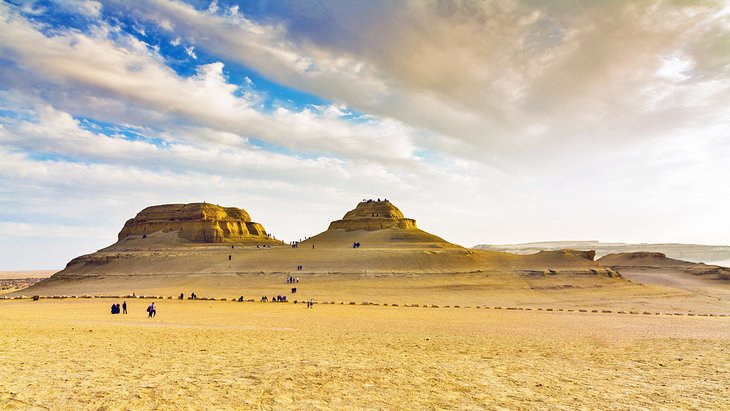
22. Ancient Heliopolis and El-Matariya
Not to be confused with the Cairo suburb of the same name, ancient Heliopolis was the Egyptian town of Yuno (known in the Greek period as Heliopolis), which is one of the oldest cities in Egypt and, from the Old Kingdom onwards, the spiritual center of the entire country.
It's a site really only for the most enthusiastic of amateur archaeologists as there are only scanty remnants left of the town and of the Temple of Re-Harakhty, which once stood here.
Most of the stones were repurposed over the centuries to build Cairo.
All that remains of the temple is a solitary obelisk made of red Aswan granite, standing 20 meters high.
Some five kilometers east of the obelisk, is the Necropolis of Heliopolis dating from the Middle and New Kingdoms. A notable feature of the Middle Kingdom tombs was the large numbers of weapons found as grave goods.
Near Heliopolis, 13 kilometers northeast from central Cairo, is El-Matariya Church with the so-called Virgin's Tree. This sycamore was planted in 1672, replacing an older tree where, according to local legend, the Virgin Mary and infant Jesus rested during their flight into Egypt.
The little garden where the tree stands is watered from a spring, said to have been called into being by the infant Jesus. The spring yields good fresh water, whereas the water of all the other springs in the area is slightly brackish.
The legend of the Virgin's tree links up with an older cult, for the ancient Egyptians venerated a tree in Heliopolis beneath which Isis was believed to have suckled the infant Horus.
Where to Stay in Cairo for Sightseeing
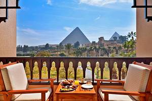
Cairo is a huge city. Many of the luxury hotels sit along the Nile River or are near the Giza Pyramids. Some of the best luxury and mid-range options are in the Garden City district and in Zamalek, both in central Cairo. Budget hotels are mostly found in the Downtown district, right in the center. Below are some highly rated hotels in convenient locations:
Luxury Hotels:
- In the Garden City district, along the Nile River, the Kempinski Nile Hotel is a charming hotel with restaurants, rooms, and suites with balconies, and a lovely pool area with views over the river and the city.
- Nearby and also overlooking the Nile, the Four Seasons offers spectacular views, three heated rooftop pools, spacious rooms and suites, along with multiple restaurants and a spa.
- At the southern end of Gezira Island, with incredible views over the Nile from the rooms, the restaurants, and the infinity pool, the Sofitel Cairo El Gezirah is an elegant five-star property with outstanding service. All of these hotels offer easy access to the downtown and surrounding attractions.
Mid-Range Hotels:
- Just steps away from the Egyptian Museum is the Steigenberger Hotel El Tahrir, one of Downtown Cairo's newest hotels, with the most comfortable rooms and modern amenities you'll find in Cairo at mid-range prices.
- For the most atmospheric mid-range stay head to Zamalek, where you'll find the Hotel Longchamps. This is a relaxing boutique hideaway from the city's never-ending din, with friendly staff and good-sized rooms that feature modern, comfortable facilities.
Budget Hotels:
- Nearly all of Cairo's budget offerings are based downtown. The Golden Hotel has spacious, air-conditioned rooms and a free continental breakfast.
- The Osiris Hotel offers basic but comfortable rooms with a dash of traditional style, while the City View Hotel has a super convenient location across the road from the Egyptian Museum, and small, comfortable rooms.
Tips and Tours: How to Make the Most of Your Visit to Cairo
A sightseeing tour is a great way to see Cairo's highlights without the hassle of finding your way around, dealing with aggressive touts, and having to negotiate prices. Instead, you can relax and enjoy the sights while you learn about the attractions from a qualified Egyptologist. These tours also include convenient hotel pickup and drop-off, as well as entrance to many of the sites. Below are some fun sightseeing tours that guarantee the lowest price:
- See the Pyramids: The pyramids are the highlight of a visit to Egypt, and the Private Tour: Giza Pyramids, Sphinx, Memphis, Sakkara takes you to see these icons, as well as other important sites out of the city, including the World Heritage-listed ruins of ancient Egypt's capital at Memphis. Since this tour is private, you have the flexibility to tailor the timing and add an optional upgrade that includes lunch and a visit to Giza's Solar Boat Museum.
- See the City Sights: If you've already seen the pyramids, the Private Tour: Egyptian Museum, Alabaster Mosque, Khan el-Khalili takes you to explore some of Cairo's other top attractions guided by an experienced Egyptologist. This full-day tour is private, so you can tailor the itinerary to suit your interests, spending more time at your favorite attractions. You can also add a visit to the Papyrus Institute.
- Egypt Major Sights and Nile Cruise: The seven-night Cairo and Aswan tour includes trips to the Egyptian Museum and the Giza Pyramids before whisking you down to Aswan for a Nile Cruise to Luxor, with a free day in Cairo at the end for you to check out the rest of the city's sights.
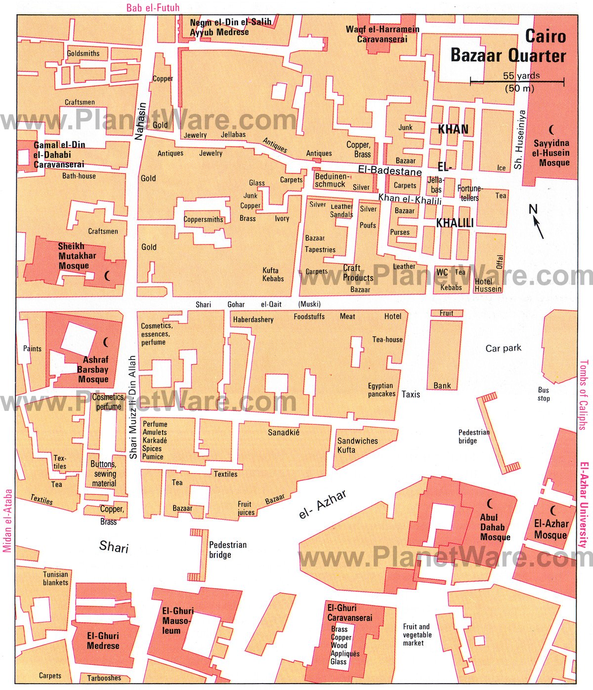
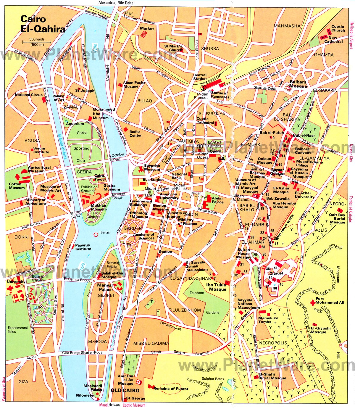
Map of Attractions & Things to Do in Cairo
Cairo, Egypt - Climate Chart
| Average minimum and maximum temperatures for Cairo, Egypt in °C | |||||||||||
| J | F | M | A | M | J | J | A | S | O | N | D |
| 18 9 | 20 10 | 23 12 | 28 15 | 32 18 | 34 21 | 34 22 | 33 22 | 32 21 | 29 18 | 24 14 | 19 11 |
| PlanetWare.com | |||||||||||
| Average monthly precipitation totals for Cairo, Egypt in mm. | |||||||||||
| 5 | 5 | 3 | 3 | 0 | 0 | 0 | 0 | 0 | 0 | 3 | 5 |
| Average minimum and maximum temperatures for Cairo, Egypt in °F | |||||||||||
| J | F | M | A | M | J | J | A | S | O | N | D |
| 65 49 | 68 50 | 73 54 | 82 59 | 89 64 | 93 70 | 93 72 | 92 72 | 90 69 | 85 65 | 75 58 | 67 51 |
| PlanetWare.com | |||||||||||
| Average monthly precipitation totals for Cairo, Egypt in inches. | |||||||||||
| 0.2 | 0.2 | 0.1 | 0.1 | 0 | 0 | 0 | 0 | 0 | 0 | 0.1 | 0.2 |
More Related Articles on PlanetWare.com
More Cities to Explore: If your Egypt travels are going to take you to the country's other major cities, be sure to check out our articles on Aswan and Luxor. Here, you can explore Egypt's vast treasure trove of temples and tombs and learn more with our articles on Abu Simbel, Karnak, and the Valley of the Kings.
- Museum of Islamic Art
- El-Muayyad Mosque
- El-Azhar Mosque
- (8) El-Hakim Mosque
- (9) Abu Bekr ibn Muzhir Mosque
- (10) Sabil Kuttab Wikala
- (11) Beit el-Suheimi
- (12) Mohammed el-Nasir Mosque
- (13) Barquqiya Mosque
- (14) El-Aqmar Mosque
- (15) Salih Ayyub Mausoleum
- (16) Khan el-Khalili
- (17) El-Ghuri Medrese and Mausoleum
- (18) Fakahani Mosque
- (19) Salih Talai Mosque
- (20) El-Mardani Mosque
- (21) Rusun Mosque
- (22) Sultan Shaapan Medrese
- (23) Sulaimaniya Mosque
- (24) Surdun Mosque
- (25) Ibrahim Aga House
- (26) Aq Sunqur Mosque
- (27) Emir Khairbek Mosque
- (28) El-Gei el-Yusufi Medrese
- (29) El-Rifai Mosque
- (30) Qani Bey Medrese
- (31) Emir Taz Palace
- (32) Emir Sheikhu Convent
- (33) Khushqadam el-Ahmedi Mosque
- (34) Beit el-Kiridliya
- (35) Shagarat el-Durr Mausoleum
- Citadel
- (36) Mohammed Ali Mosque
- (37) Bir Yusuf (Joseph's Well)
- (38) El-Nasir Mosque
- (40) Moqattam Tower
- (41) Military Museum
- St Joseph
- National Circus
- Palace of Art
- Mohammed Khalil Museum
- St Mark's Church
- Sinan Pasha Mosque
- Ramesses Square
- Coptic Cathedral
- Opera Square
- Coptic Church
- New Cathedral
- Baibars Mosque
- Baibars Convent
- Qalaun Mosque
- Musafirkhane Palace
- (1) United Kingdom Embassy
- (2) United States Embassy
- (3) Foreign Ministry
- (4) Supreme Court
- (5) Gumhuriya Theater
- Mukhtar Museum
- Egyptian Museum
- Ethnological Museum
- Geological Museum
- Abdin Palace
- Agricultural Museum
- Cotton Museum
- Museum of Modern Art
- Papyrus Institute
- (6) Emir Salar and Sanjar Mausoleum
- (7) Qait Bey Mosque
- Church of St George
- Ibn Tulun Mosque
- Amr Ibn el-As Mosque
- Manisterli Palace
- Nilometer
- (26) Aq-Sunqur Mosque
- Sultan Hasan Mosque
- Tombs of the Mamelukes
- Fort Mohammed Ali
- El-Giyushi Mosque
- El-Shafi Burial Mosque