12 Top-Rated Day Trips from Geneva
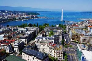
From your first look at Geneva, on the shore of beautiful Lake Geneva and surrounded by Alpine peaks, you'll see the possibilities for day trips. You'll find that the lake and mountains offer as many things to do as the city itself, from strolling the romantic old lanes of lakeside towns to marveling at glaciers high in the Alps.
On a day trip, you can ride mountain railroads and cable cars for spectacular views, visit Alpine gardens, relax in a spa, or ski and return for dinner in Geneva.
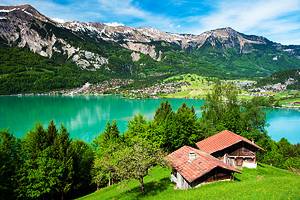
Many of these day-trip destinations can be reached by boats that ply Lake Geneva on a regular schedule. You can cruise around the lake and enjoy the scenery, hopping off the boat right in the heart of lakeside towns and cities. The steamers stop right at Chateau Chillon, one of the top places to visit in Switzerland.
As Geneva sits almost at the international border with France, it's also easy to visit the French Alps and go sightseeing in traditional French villages. Learn all about the attractions and things to do near this cosmopolitan city with our list of the top day trips from Geneva.
1. Take a Scenic Tour of Lake Geneva
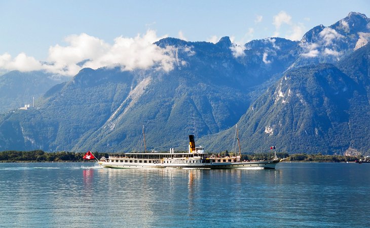
Depart from any one of the four quays along the lakefront for a boat tour of Lake Geneva that reveals magnificent mountain views, lush green hillsides with picturesque stone villages, lakeside resorts lined with Belle Epoch hotels, and the famous Château de Chillon rising out of the water. You can leave the boat at any of these to explore, rejoining a later cruise or returning by train for a different set of views of the Swiss Riviera.
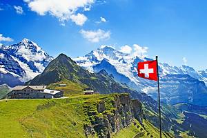
At Montreux, you can board the narrow-gauge Rochers-de-Naye rack railway that climbs to 360-degree Alpine views. Eight of Lake Geneva Navigation Company's 20 boats are historic paddle wheelers, and on any, you can choose a seat on the deck or in glass-walled salons.
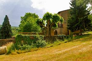
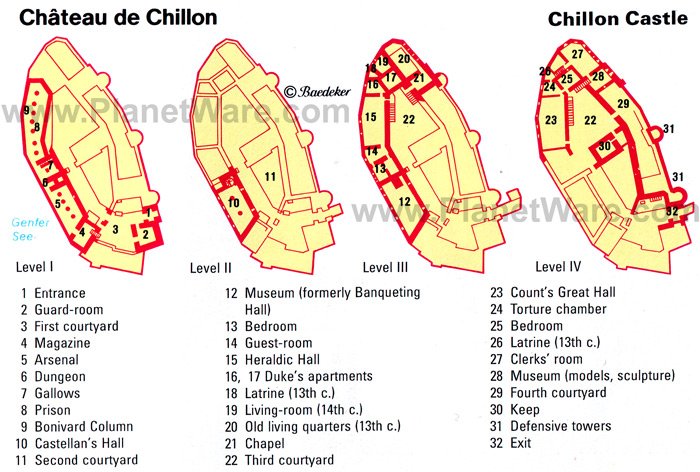
2. Château de Chillon
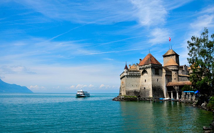
The formidable walls of the 9th-century Château de Chillon rise directly from the waters of Lake Geneva in one of Europe's most dramatic settings for a castle. Its literary fame as the basis for Byron's The Prisoner of Chillon arises from a true story, and you can still see the ring in the wall where François de Bonivard was held.
The Counts and Dukes of Savoy gave the castle its present form in the 13th century, but you can still explore the original foundations and cavernous underground vaults with massive pillars carved out of bedrock. Follow the well-marked tour route to see the entire castle complex, which includes upwards of 20 buildings.
Costumed guides add to the experience in some rooms with stories that bring the castle to life. Highlights of this popular tourist attraction are the kitchen, banqueting hall, Bernese Room, Heraldic Hall, the Duke's apartments, St. George's Chapel, and the Count's Great Hall with its splendid coffered ceiling and Gothic arches.
Address: Avenue de Chillon 21, Veytaux
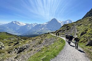
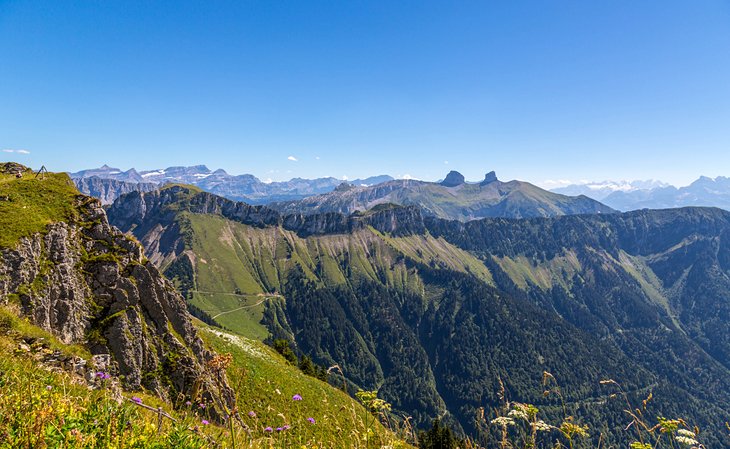
3. Hike or Ride up Mont Saleve
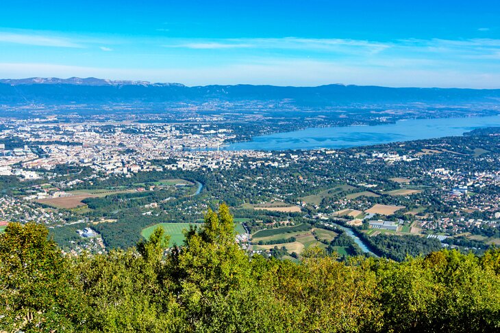
On the French border south of Geneva, Mont Saleve is a limestone ridge that offers outstanding views of the lake and the Alps. Along with the views, you can enjoy hiking and rock climbing here, or simply take the six-minute cable car from Veyrier, at the French border, for sightseeing at an elevation of 1,143 meters.
A short distance beyond Veyrier is the summer resort of Mornex, on the southern slopes of the Petit Salève. From the resort of Monnetier, in a cleft between the Petit and Grand Salève, it is a half-hour climb to the summit of the Petit-Salève.
At 1.5 kilometers from the Monnetier, a road on the right leads to magnificent views of the Mont Blanc chain, Lake Geneva, and the Jura, as well as to a path (also about a 30-minute climb) ascending to the Crêt de Grange-Tournier. At 1,308 meter`s, this is the highest point on the Grand Salève.
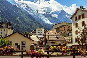
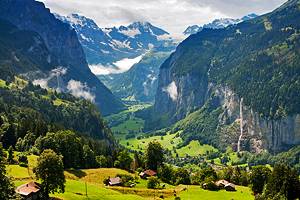
4. Chamonix and Mont Blanc
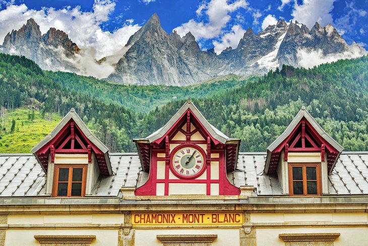
The small mountain village of Chamonix, over the border in France, is less than 90 minutes away, reached on a drive through the spectacular Arve Valley, with the snowcapped French Alps rising ahead. Chamonix sits at the foot of Mont Blanc, Western Europe's tallest peak at 4,800 meters altitude.
For even better Alpine views, ride the cable car to the peak of Aiguille du Midi for a panorama that includes Mont Blanc and the French, Swiss, and Italian Alps. Its rocky summit has snow year-round and on a clear day, you can see the Matterhorn.
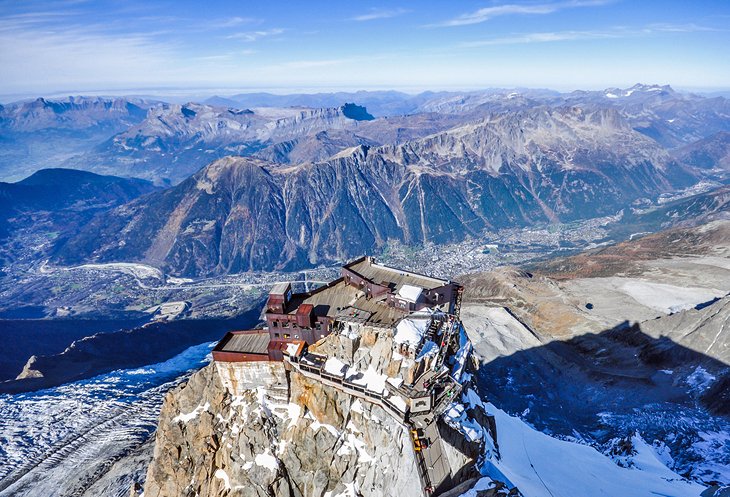
A cog railway makes the scenic climb to Montenvers and the Mer de Glace, a "sea of ice" where you can visit ice caves, and a museum with displays on the glacier and the building of the Montenvers railway. Although the main allure of Chamonix is its access to the Alps, the town itself is attractive, its streets lined with chalets, shops, and cafés, where you can sip hot chocolate and admire the scenery.
You can include all these on a 9.5-hour Chamonix and Mont Blanc Day Trip from Geneva, traveling into the Alps by comfortable coach and ascending the Aiguille de Midi in a modern cable car. The tour then continues by cog railway to Montenvers, to see the famous glacier, Mer de Glace.
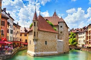
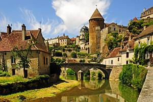
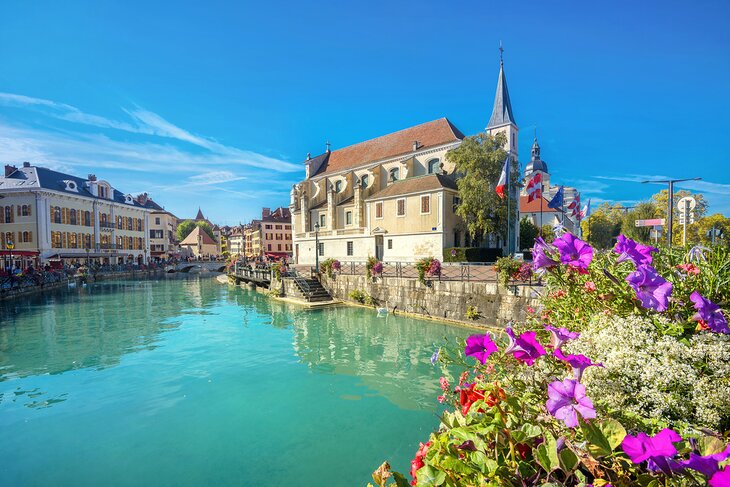
5. Annecy
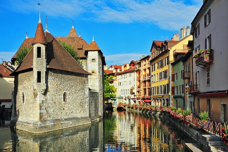
For sheer charm, not to mention its near-perfect setting beside a mountain-backed lake, it's hard to beat the French town of Annecy, about an hour's drive from Geneva. The Counts of Geneva made Annecy their home and headquarters in the early 1200s, and you can learn more about the town's history at the museum inside the Château d'Annecy, a restored castle that dominates the Vieille Ville (old town).
But the best way to enjoy Annecy is simply to stroll its narrow streets and soak up the scenery of medieval houses that line its canals and lanes. Canals surround the Palais de l'Isle, a 12th-century fortress that was once a prison. Today, it vies with the graceful Lovers' Bridge as Annecy's favorite photo op.
An easy way to get here is on a five-hour Annecy Half-Day Tour from Geneva, traveling across the border by coach and taking a walking tour of Annecy's landmarks with a professional guide before enjoying time to explore on your own. You can choose a morning or afternoon tour.
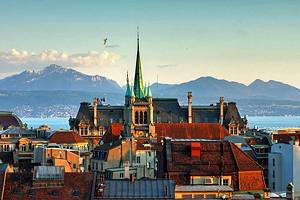
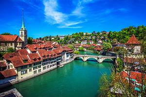
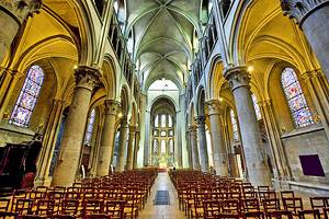
6. Lausanne
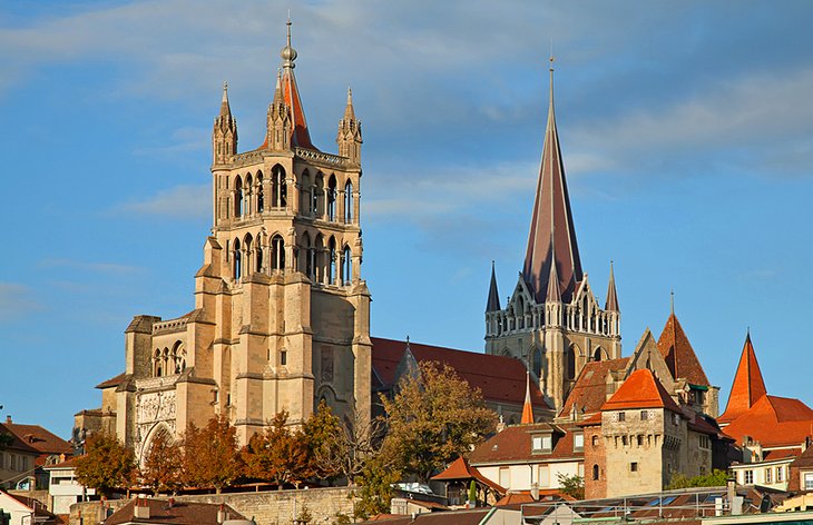
While this city on the north shore of Lake Geneva is usually thought of as a center of business and commerce, which it most certainly is, Lausanne is also a beautiful city and an interesting place to visit. Its streets and a trolley line climb steeply from the steamer landing and shoreline promenade to the cathedral. This important medieval landmark has a 13th-century Apostles Doorway of painted stone sculptures and a glorious 13th-century stained glass rose window.
Descend via the picturesque Escaliers du Marche, a long covered flight of steps, to Place de la Palud, where you'll find Lausanne's oldest fountain and an animated clock that reenacts scenes from local history every hour. On Wednesday and Saturday mornings, the square and adjoining streets become a lively farmers market.
Along the lakeshore, a garden-edged promenade lined by grand Belle Epoch hotels connects the steamer landing and 12th-century castle of Château d'Ouchy with the Olympic Museum. Lausanne is the world headquarters of the Olympics. Other outstanding museums exhibit fine arts, art brut, contemporary design, and photography, as well as Lausanne's Roman past.
7. Vevey
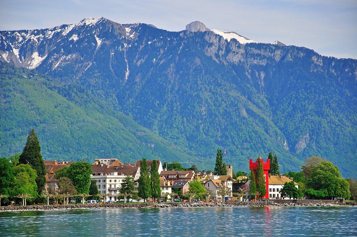
One of the prettiest towns on the lake, Vevey combines medieval buildings with Belle Epoch style and makes them seem right at home with each other. At its center is one of Europe's largest market squares, filled on Tuesday and Saturday mornings with local farmers, food producers, florists, and craftspeople.
Vevey was the home of Charlie Chaplin, whose statue overlooks the lake. Nearby, its presence announced by a giant fork standing in the lake, is the excellent Alimentarium an interactive museum of food history, sources, traditions, lore, and science.
Farther along the lakeside promenade are beautiful hotels from the late 1800s, the star of which is Grand Hotel du Lac, made famous by the Booker prize-winning novel that was both set and written here. A castle at the edge of the lake contains a small museum. Vevey is known for both its dining and its shopping.
8. Montreux and the Rochers-de-Naye Railway
The lakeside city of Montreux rings with Belle Epoch grandeur, with its grand hotels, flower-studded terraces, and promenades along the water. Each summer in June and July Montreux hosts the world-famous Montreux Jazz Festival. For a sense of the opulence of late 19th-century travel, step inside the grandest of the Swiss Riviera's grand hotels, the Fairmont Le Montreux Palace, which is still the haunt of visiting celebrities.
For views of the lake from on high, as well as panoramic Alpine vistas, take the train to Glion, in the hills above town, and board the Rochers-de-Naye rack railway for the scenic ride up to the mountain top of the Rochers de Naye. At the summit, if you can tear your eyes from the views in every direction, visit the marmot house, the small nature museum, and the vertiginous La Rambertia Alpine gardens. In the winter, this becomes a center for Alpine skiing.
9. Gruyères
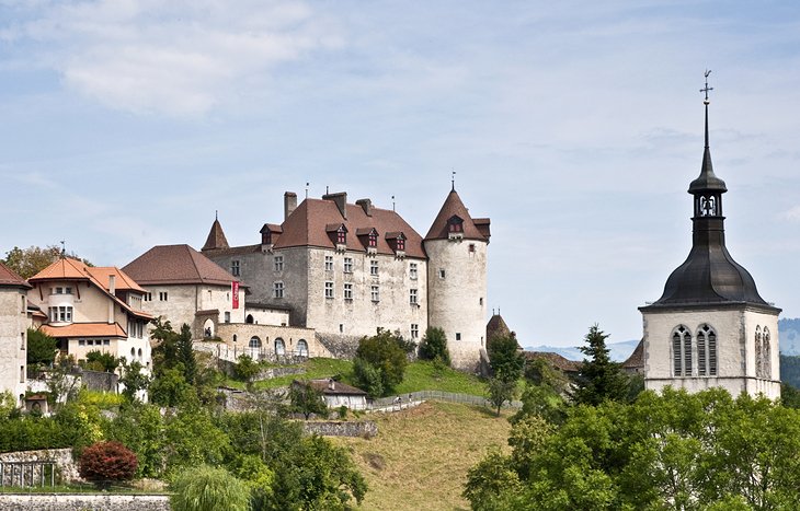
The name of this hilltop village is forever linked with that of the local cheese, and on a day trip here, you can watch this famous cheese being made and sample the real thing. The village itself is postcard perfect, topped by a large medieval castle, Château de Gruyères. Exhibits inside reflect its eight centuries of history, and below is a formal garden.
As well-known as its cheese is the chocolate produced here, and you can visit Maison Cailler, the chocolate factory in Broc, on the way to Gruyeres. An easy way to see both is on the Day Trip to Gruyères Medieval Village & Chocolate Factory from Geneva. The full-day excursion includes guided tours and tastings at both.
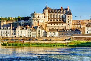
10. Evian-les-Bains
The French town of Evian, on the southern shore of Lake Geneva, was known as a spa town by the mid-1800s, its fame enhanced by the mineral water that was bottled from its springs. Its therapeutic qualities had been identified in the late 1700s by an aristocrat fleeing the French Revolution.
To underscore its position as a spa town, the name was changed in 1865 to Evian-les-Bains. By the end of the century, there were more than 20 hotels, and its shore and the hillsides behind it were studded with villas.
Like the elaborate pump house, built in 1902, many of these were in the fashionable Art Nouveau style; the hotels favored the grandiose Belle Epoch architecture, as did the extravagant Palais Lumière, built as a fashionable spa. Now a venue for art exhibits, the interior of the Palais Lumière is an extravaganza of Art Nouveau decoration.
Evian is still one of Europe's most fashionable spas, a genteel world of lakeside parks and promenades, villas, and grand hotels that have hosted a litany of famous guests: English and Egyptian kings, maharajas and the Aga Kahn, as well as socialites and the literati, including Marcel Proust.
11. Yvoire
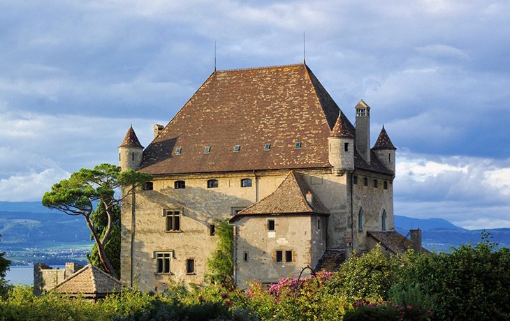
From the first view of its medieval stone-paved lanes, well-preserved buildings, and flower-draped balconies, it's easy to see why Les Plus Beaux Villages de France named Yvoire one of France's most beautiful villages.
The setting at the end of a small peninsula with the snow-covered Savoy Alps as a backdrop only enhances the scene. It's a town for wandering, stopping in cafés and shops to admire the work of local artisans.
For determined sightseers, there is a museum of local history inside the 14th-century castle, Château d'Yvoire, and Le Jardin des Cinq Sens, a garden designed to appeal to all five senses. If you can, plan to travel at least one way by lake steamer, for the best views of Yvoire sitting along the lake with the Alps behind it.
12. Spend a Day Skiing
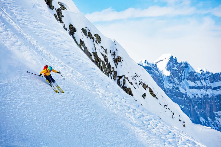
Geneva is surrounded by some of the best skiing in Europe, with world-class ski resorts as close as an hour away. In less than 90 minutes, you have an even wider choice. Make the most of a winter trip with a day skiing at one of these top French ski resorts.
An hour from Geneva, La Clusaz is known for its reliable snow conditions (the slopes reach up to 2,600 meters altitude) and wide variety of terrain for all levels of skier.
The same distance from Geneva, Samoëns, France, is also a great place for beginning and intermediate skiers but will challenge experts with some of the steepest pistes in the Alps. The town is a charmer, a typical Savoy mountain village of stone houses with Mont Blanc rising majestically behind it.
Only 15 minutes farther from Geneva is one of the top ski resorts in France, the famous Chamonix, on the slopes of Mont Blanc. Although there's plenty of terrain for every level, expert skiers and riders will be especially happy here.