13 Top-Rated Attractions & Things to Do on the Gaspé Peninsula
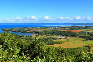
There are so many things to do in the Gaspé Peninsula that it's hard to believe it's only 250 kilometers long and 100 to 140 kilometers across. Extending into the Gulf of St. Lawrence and isolated from the rest of Québec, the peninsula rises quickly from its scenic coast to a mountainous, wooded inland wilderness. Between the sea and the interior mountains, the Gaspésie is a paradise for outdoor sports, from hiking, mountaineering, and backcountry skiing to kayaking, fishing, sailing, and even scuba diving.
But the tourist attractions of the Gaspé Peninsula are not all active ones: museums explore the long history (it was here that Champlain first landed in North America), Micmac culture, early wireless communication, fishing, and fossils. Picturesque lighthouses and tidy villages dot the shore. Scenic vistas are everywhere, but none compares to the peninsula's premier spot for sightseeing: the famous 88-meter-high Percé Rock jutting out of the sea.
Not least of the Gaspé Peninsula's attractions is its excellent cuisine. Local specialties uphold the best of French tradition with game, fish, and seafood, including local trout and Atlantic salmon. You can experience the highlights of this beautiful region with the help of our list of the top attractions on the Gaspé Peninsula.
- 1. Forillon National Park
- 2. Percé Rock
- 3. Bonaventure Island
- 4. Gaspé
- 5. Whale Watching & Sea Adventures
- 6. Pointe à la Renommée
- 7. Bonaventure
- 8. Parc National de la Gaspésie
- 9. Ste-Anne-des-Monts
- 10. Micmac Cultural Interpretation Site
- 11. Parc National de Miguasha Fossil Site
- 12. Musée de la Gaspésie
- 13. Matapedia
1. Forillon National Park
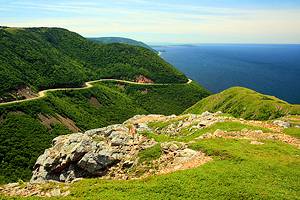
At the tip of the Gaspé Peninsula, this scenic park juts out into the Gulf of St. Lawrence. Forillon National Park's northern coast is wild and rugged with mostly limestone cliffs. The southern coastal strip is less grand, but just as impressive, with opportunities for bird-watching and for whale watching trips by boat.
You can learn more about the wildlife of the area at the information center at Cap des Rosiers-which is also the site of a historic lighthouse, the tallest in Canada. Farther on, at Cap Bon-Ami, a narrow path leads down to the beach for a magnificent view of the cape and the cliffs.
Address: 122 Gaspé Blvd, Gaspé
Official site: http://www.pc.gc.ca/pn-np/qc/forillon/index.aspx
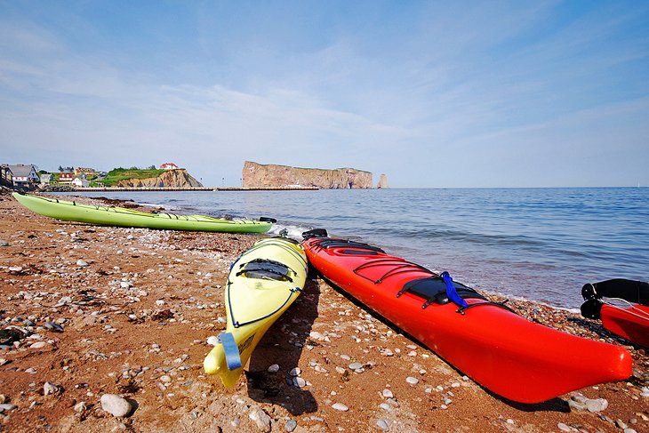
2. Percé Rock
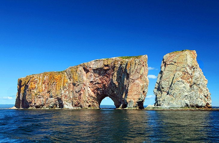
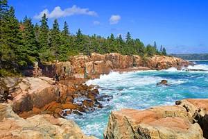
The signature image of the Gaspé Peninsula is gigantic red Perce Rock rising majestically from a deep blue sea. And it's just as beautiful in reality. Eons of battering by the sea have eroded the rock, which is pierced (percé in French, hence the name) by a large hole at one end. This is the most dramatic point, but the whole coast is a magnificent natural spectacle of photogenic rocky outcrops, towering cliffs, and surf.
Samuel de Champlain described this 88-meter-high, 475-meter-long rock in his captain's log in 1603, and you, too, can get a view of it from the water on one of the several boat excursions from the town of Perce.
In 2017, the Plateforme Vitrée Suspendue (suspended glass platform) at the Geopark of Percé, a viewing stage cantilevered out from a Mont Ste-Anne cliff at 200 meters altitude, offering yet another perspective on the iconic rock. An interpretive center at the Geopark has an interactive multimedia exhibition, Tektonik, that's especially appealing to children.
3. Bonaventure Island
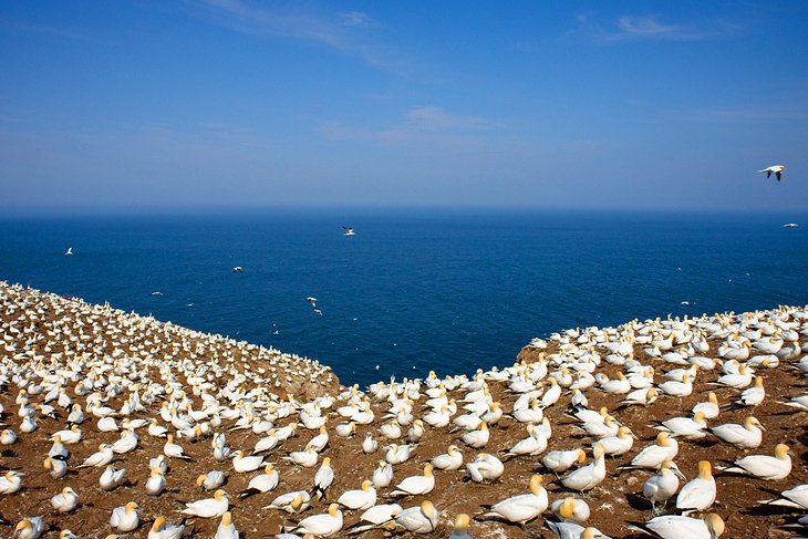
The island of Bonaventure is a bird sanctuary covering about four square kilometers. It is North America's largest gannetry-about 50,000 gannets come here in summer to nest. The eastern side of the island is an ideal nesting site, with rocky clefts and ledges. Besides the gannets, there are cormorants and other seabirds, as well as trails, so that visitors can see them better.
From the boat dock, follow the 5.6-kilometer (round-trip) Les Colonies trail across the island to the gannet colony. Or you can follow the nine-kilometer Le Chemin du Roy around the entire perimeter of Bonaventure Island. The views are spectacular. For bird-lovers, the gannetry on Bonaventure Island is one of the top things to do in Quebec.
Official site: http://www.sepaq.com/pq/bon/
4. Gaspé
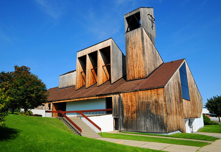
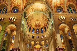
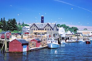
Gaspé, the main town of the peninsula and the administrative and commercial center, is on a hillside overlooking the York River. The town owes its fame to Jacques Cartier, since it was here that he first set foot on the continent of North America in July 1534, fashioned a wooden cross, and took possession of the land "in the name of the King of France." Today Gaspé is a community based on fishing and the fishing industry, and worth a stop for some sightseeing as you tour the eastern end of the peninsula.
The striking modern Christ Roi Cathedral is built almost entirely of wood and is the only wooden cathedral in North America. Designed by architect Gérard Notebaert, the new cathedral was consecrated in 1969, and has beautiful stained glass.
5. Whale Watching & Sea Adventures
Largely surrounded by water, it's no wonder that Gaspé is filled with chances to explore and play on the water. For tourists, one of the most popular things to do is take a cruise around Perce Rock for different perspectives and great photo ops. Les Bateliers de Percé cruises also go to Bonaventure Island to see the gannets.
As many as six different species of whales frequent the waters off Forillon National Park, including blue and humpback whales. Cap Aventure operates whale watching cruises from the marina in Gaspé with a professional interpreter-guide.
Avolo Plein Air in Percé leads guided kayak tours of the point St-Peter's area, offering outstanding views of Percé and Forillon, and the chance to explore unique rock formations.
Écovoile de la Baie-des-Chaleurs does day trips under sail from Carleton-sur-Mer on the Bay of Chaleur. To explore underwater, you can go scuba diving with Plongée Forillon, at the Quai de Grande-Grave in the National Park.
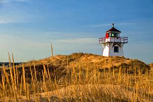
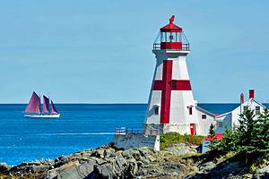
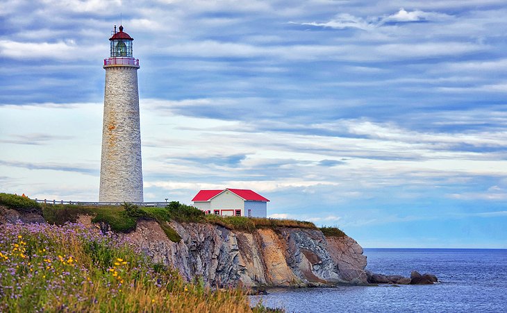
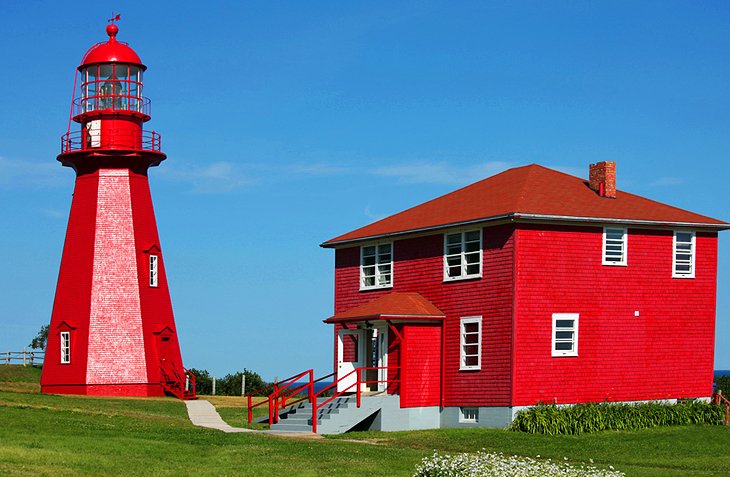
6. Pointe à la Renommée
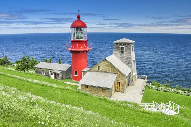
The Site Historique de Pointe-à-la-Renommée combines a striking red lighthouse with the site of North America's first maritime radio station, which was installed here by inventor Guglielmo Marconi in 1904.
The lighthouse keeper's house has a video about the lighthouse and those who tended its lights, and you can climb to the top for magnificent views of the shore and the St. Lawrence. The displays in the museum tell the story of Marconi's station and its role in the development of radio communications.
7. Bonaventure
This little holiday community on the Bay of Chaleur was founded by Acadians fleeing here to escape deportation, and you can learn more about the Acadian culture at the Musée Acadien du Québec. A good place to visit for families is the Bioparc, a small zoo with about 40 animals that are native to the Gaspe. Activities throughout the park encourage children to learn more about the animals and their environment.
About 20 kilometers east of Bonaventure, Banc de Paspebiac Historical Site has 11 restored buildings that tell the story of the local fishing industry over the last two centuries. Demonstrations of traditional shipbuilding skills, net-mending, blacksmithing, and barrel-making, as well as theatrical performances bring the village to life, making this another good attraction for families.
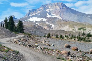
8. Parc National de la Gaspésie
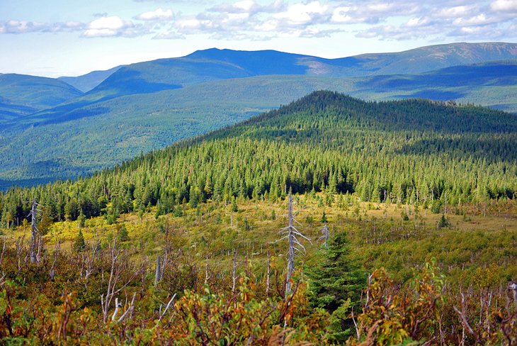
More than 25 peaks over 1,000 meters high crown the two mountain ranges in this national park in the heart of the Gaspé Peninsula. The Chic-Choc and McGerrigle ranges are accessed by 140 kilometers of hiking tracks that include one of the best stretches of the International Appalachian Trail. A favorite climb is Mont Jacques-Cartier, Québec's second highest summit. The higher reaches of the park are the habitat for a herd of rare woodland caribou.
Mont Albert, a peak in the Chic-Choc range, is well known to avid backcountry skiers in Quebec, but remains a well-kept secret outside the region. Mountain streams and lakes make the area popular for fishing, and there are campsites throughout the park.
Address: 1981 Route du Parc, Sainte-Anne-des-Monts, Québec
Official site: https://www.sepaq.com/gaspesie
9. Ste-Anne-des-Monts
The road to Ste-Anne-des-Monts is typical of the rocky coast. The route runs through impenetrable terrain, either at the water's edge or along the cliff tops, and passes through many little fishing villages with relatively large churches, small houses, and nothing but waves and seagulls as far as the eye can see. The bright-red La Martre Lighthouse and Museum is situated about 15 kilometers east of the town.
At the dock, you'll find Exploramer, an interactive museum that explores the marine life of the St. Lawrence River. The aquarium, touch pools, activities, and sea excursions on board the JV Exploramer all focus on the river, its inhabitants and environment. Visiting here is a popular thing to do for families; kids especially like putting on waders to explore the riverbed at low tide and collect sea life to examine.
10. Micmac Cultural Interpretation Site
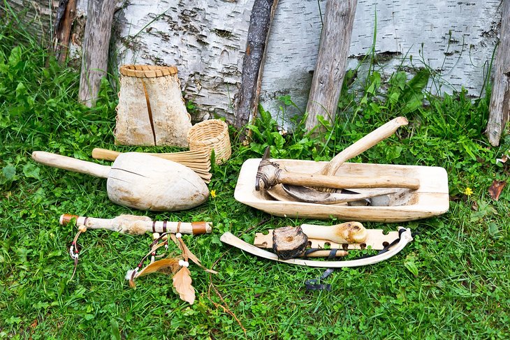
The Micmac Cultural Interpretation Site (Site d'interpretation de la culture Micmac de Gespeg) demonstrates how the local Micmac people have lived in the Gaspé for the past three centuries, with a replica traditional village and summer camp of bark-covered homes. Displays and the guided tour illustrate daily life, food gathering, and traditional arts and skills. There is an emphasis on the Micmac's spiritual life and their relationship to the natural environment.
A shop exhibits outstanding examples of contemporary arts and crafts by members of the Gaspé Micmac Nation. The tour finishes with samples of traditional foods.
Address: 783 Boulevard Pointe-Navarre, Gaspe, Quebec
Official site: www.micmacgespeg.ca/en/explore
11. Parc National de Miguasha Fossil Site
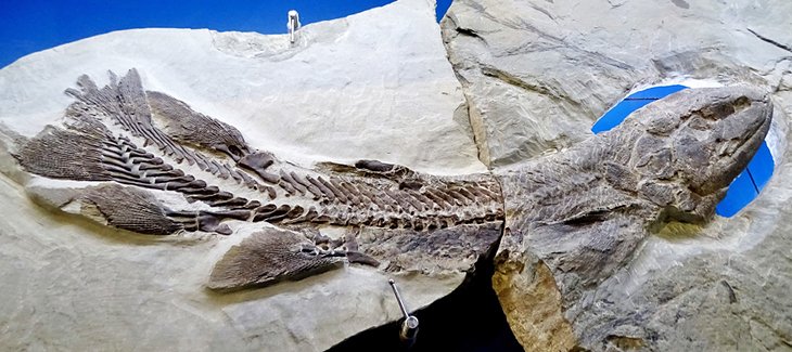
One of the world's premier sites, along with two in western Nova Scotia, illustrating the transition of fish to creatures able to walk on land, Parc National de Miguasha is listed as a UNESCO World Heritage Site. Fossils found here illustrate fish from 370 million years ago with rudimentary bones in their fins that show the beginning of arms and legs. These are called lobe-finned fishes, and they provide the link between fish and the first four-legged terrestrial vertebrates that could breathe out of water-the tetrapods.
The fish, invertebrate, and plant fossils shown in the interpretive center exhibits are of exceptional quality and are the very ones that have been used by paleontologists to form our understanding of the evolution of sea-to-land creatures. You can tour the beach to discover fossils that have fallen from the cliffs (but you are not allowed to collect them) or you can join a guided tour to learn even more about the site and its importance to scientific understanding of vertebrate origins.
Address: 231 Route de Miguasha Ouest, Nouvelle, Québec
Official site: https://www.sepaq.com/pq/mig/index.dot
12. Musée de la Gaspésie

Opened in June 2021, the Gaspé Museum celebrates the history, land, and people of the region with modern immersive exhibits and programs. Among the permanent exhibits, The Deep Blue Sea explores the maritime history of the Gaspésie through 15 sailing vessels and the experiences of people whose lives revolved around the sea. You'll see canoes of the Mi'gmaq and learn about whalers and cod fishing.
In addition to the indoor exhibition area, outdoors you'll find, La Gaspésienne no. 20, an authentic cod fishing boat restored and outfitted with fishing gear and equipment; you can board it from June through October. Also on the grounds are exhibits and sculptures by contemporary artists, including one commemorating the meeting between Jacques Cartier and the St. Lawrence Iroquoians in 1534.
In the summer, outdoor programs include a lively presentation about Jacques Cartier and the people he met during his travels.
Address: 80 boulevard Gaspé, Gaspé, Québec
Official site: https://en.museedelagaspesie.ca
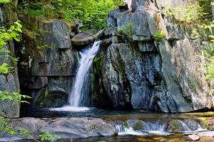
13. Matapedia
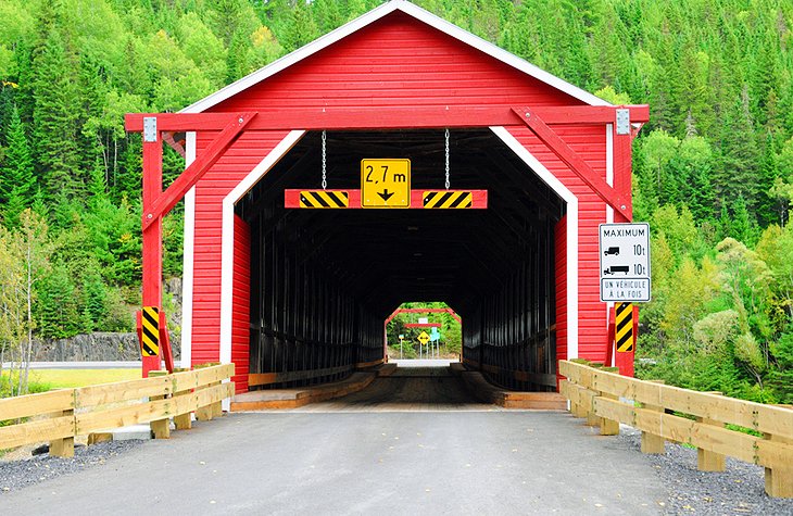
Just across the line from New Brunswick, the village of Matapédia is in a lovely setting between two famous salmon rivers-the Matapédia and Restigouche-amid green hills that are known for their brilliant display of fall color. A number of covered bridges, some open to traffic, others pedestrian only, have been preserved from the early 20th century.
Well signposted from Chemin Petit, Chutes a Picot are often listed as one of the most beautiful waterfalls in Quebec. In the winter, Le Petit Chamonix ski resort offers downhill and cross-country skiing, as well as snowboarding, tubing, and ice-skating.
More Related Articles on PlanetWare.com
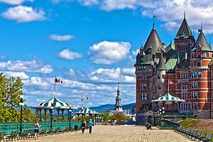
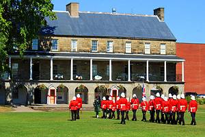
Where to Go in Quebec: The Gaspé Peninsula is only one of the many regions where tourists will find attractions to visit in Quebec. Both Montreal and Quebec City are lively centers of French-Canadian culture, and you'll find many charming and historic places to stay in Old Quebec.
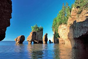
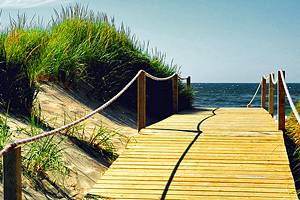
Where to Go in New Brunswick: From the Gaspé, you can drive south to explore the tourist attractions in New Brunswick, which lies at the other side of the Bay of Chaleur. While here, you will want to see all the natural wonders of the Bay of Fundy, and you can discover more things to do by referring to our handy pages on the lively cities of Saint John, Fredericton, and Moncton.