15 Top-Rated Attractions & Things to Do in Banff National Park
Author Lana Law travels to Banff National Park on a regular basis to hit the slopes in the winter and to hike the high alpine walking trails in the summer.
Banff National Park is one of Canada's great national treasures, attracting millions of visitors every year. Encompassing a portion of the Rocky Mountains, the park is home to beautiful turquoise lakes mirroring the snow-covered peaks, along with glaciers and forests. Since 1985, it has been included in UNESCO's list of protected natural and cultural monuments.
The picturesque little town of Banff is the only township in the park and is the main hub of activity. The Icefields Parkway, which winds for 230 kilometers through the 3,000-meter-high mountains, connects Banff and Jasper National Park to the north.
The main highlights of this impressive journey along the Parkway are the world-famous Lake Louise, the aristocratic-looking Canadian Pacific hotel Château Lake Louise, and the huge Columbia Icefield. You also have a good chance of seeing some of Canada's wildlife. The park is home to a large number of black bears, elk, caribou, wolves, beaver, and grizzly bears.
Get a head start planning which places to visit by reviewing our list of attractions and things to do in Banff National Park.
- 1. Explore the Town of Banff
- 2. Paddle, Hike, or Relax at Lake Louise
- 3. Drive the Icefields Parkway
- 4. Hike the Best Trails in Banff National Park
- 5. Hit the Slopes at Lake Louise Ski Resort
- 6. Gaze across Moraine Lake
- 7. Ski and Board at Sunshine Village Ski Resort
- 8. Make a Stop at Bow Lake
- 9. Enjoy the View over Peyto Lake
- 10. Sightsee along the Bow Valley Parkway
- 11. Walk through Johnston Canyon
- 12. Lake Minnewanka
- 13. Spot Wildlife in Banff National Park
- 14. Soak in Banff Upper Hot Springs
- 15. Cave and Basin National Historic Site
- Best Time to Visit Banff National Park
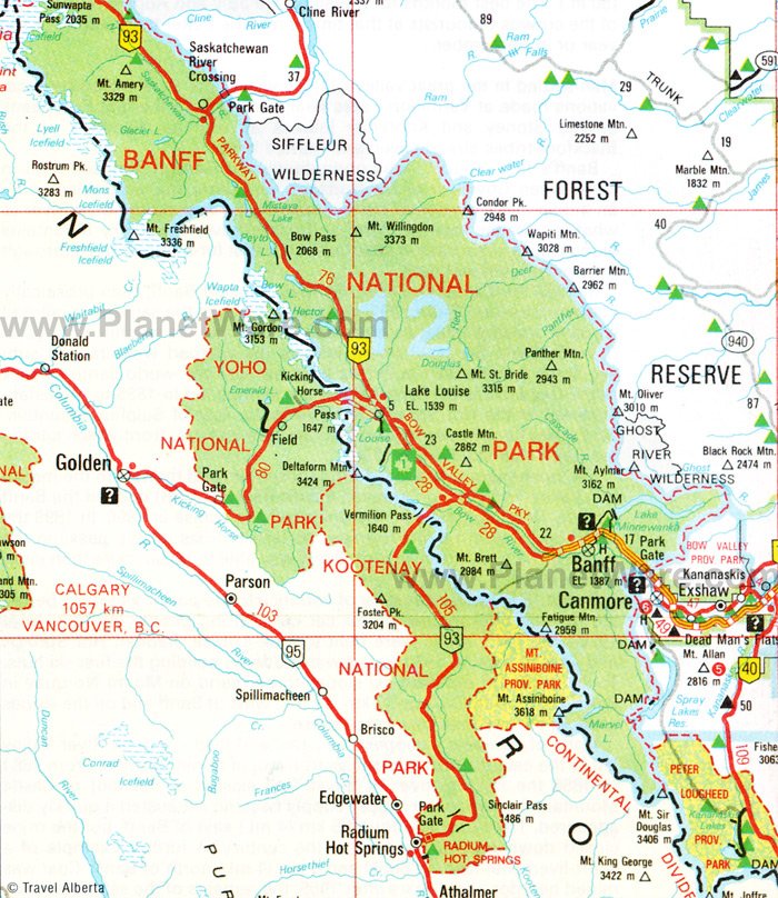
- Map of Attractions & Things to Do in Banff National Park
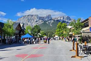
1. Explore the Town of Banff
Highlights: Historic hotel, scenic main street, Sulphur Mountain Gondola, Bow River Falls
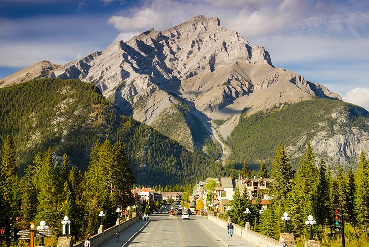
Located in the south end of Banff National Park, this little town, surrounded by mountains, is one of the main tourist destinations in Alberta. It is devoted to the tourism industry with all kinds of accommodation options, interesting shops, and restaurants that range from casual to high-end.
In the summer, the streets are packed with tourists from all over the world who come to see the Canadian Rockies, and in winter, the town maintains its lively atmosphere as skiers descend on Banff to enjoy the nearby slopes.
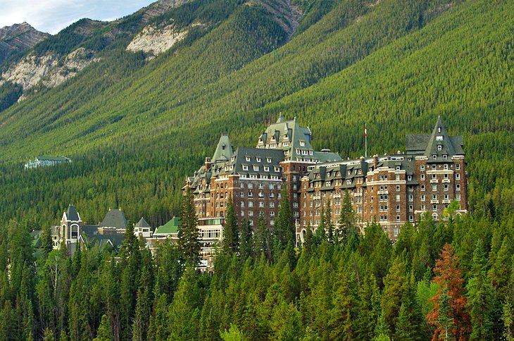
Banff Springs Hotel: One of the main highlights in Banff is the Fairmont Banff Springs Hotel. This historic hotel was built in 1888 and is today the emblem of Banff. Once planned to be the largest hotel complex in the world, this traditionally-designed, castle-like grand hotel still preserves much of the glamour of the early days of railway tourism. In those days, only well-to-do travelers could afford to make the journey into the then-still remote region of the Canadian Rocky Mountains.
The hotel is set off on its own in a wooded area with lovely views of the surroundings. Below the Banff Springs Hotel, easily reached on foot from downtown Banff, the Bow River tumbles over a cliff-like rise.
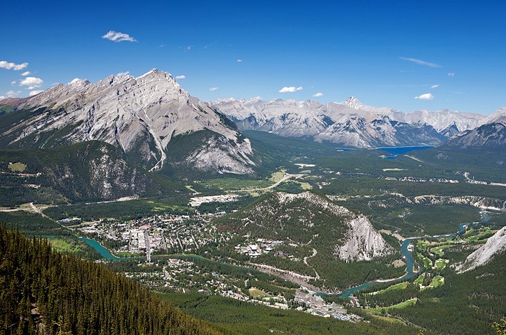
Sulphur Mountain: For fabulous views of the town of Banff and the entire valley, one of the best places to visit in Banff is Sulphur Mountain. Taking a ride on the Sulphur Mountain Gondola is one of the most popular things to do in summer. The parking area is just four kilometers outside Banff.
On a clear day, there is a splendid view from the three terrace decks and the mountain-top restaurant. At the top are a number of walking options, including the Banff Skywalk (Vista Trail), an easy one-kilometer trail that leads to the Cosmic Ray Station National Historic Site of Canada and the Sanson's Peak Meteorological Station.
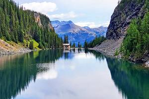
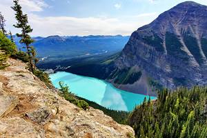
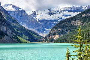
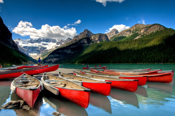
2. Paddle, Hike, or Relax at Lake Louise
Highlights: Stunning views, glaciers, easy walks along the shoreline of Lake Louise
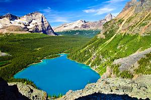
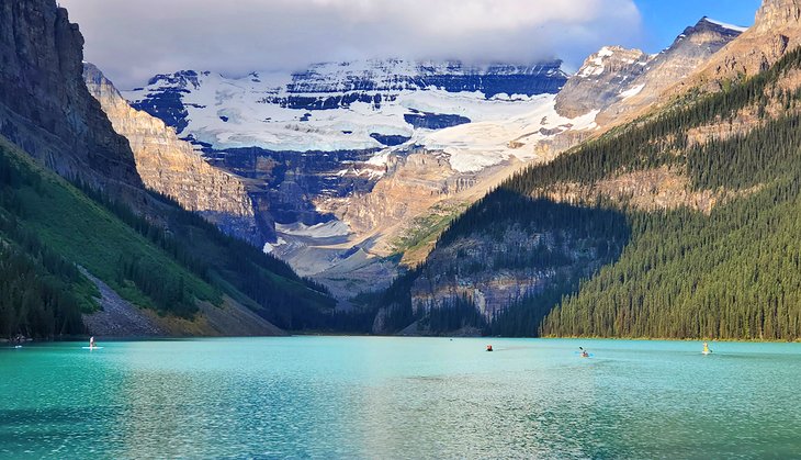
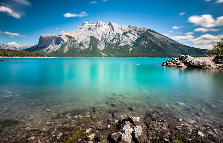
The jewel of Banff National Park is Lake Louise with its shimmering turquoise green water and surrounding snow-capped mountains rising up to 3,000 meters high. Although the water is too cold for swimming, it is ideal for canoeing. At the western end of Lake Louise, Mount Victoria (3,469 meters), rises in majestic splendor.
A breathtaking view can be had from the famous Fairmont Château Lake Louise or the shoreline in front of the hotel. This is one of the top resorts in Alberta. Even if you don't stay here, it's one of the best places for a meal. From the resort, a paved trail runs along the water's edge with beautiful views of the lake, mountains, glaciers, and the Château.
If you are staying in Banff and looking for an easy way to see some of the beautiful surrounding lakes, including Lake Louise a great option is the Lake Louise and Moraine Lake Tour. This four-hour-and-15-minute, small group guided tour takes you to all the major highlights of both areas. It also allows you to avoid all the hassles of trying to find parking and booking shuttle buses.
A very important note about parking: If the parking lots fill up, the park service closes the road, and you will be forced to use the buses. Only limited parking is available at Lake Louise and the park has recently instituted shuttle buses to alleviate congestion. These buses leave from the Lake Louise Park and Ride center, located off the Trans Canada Highway six kilometers from the Lake Louise town site, and depart every 15 minutes from 8am to 6:30pm. Reservations are required and can be booked starting April 1st of each year.
Your ticket to Lake Louise also includes a ride on the connector shuttle to Moraine Lake.
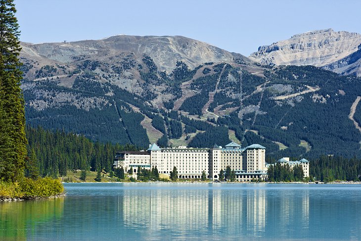
Château Lake Louise: This iconic hotel is part of the scene at Lake Louise and a nice place to have lunch overlooking the lake. In 1890, the Canadian Pacific Railway built the first Château Lake Louise on the moraine at the end of the lake. Easily accessible by rail, Lake Louise and the surrounding countryside soon developed into a tourist center. From here, expeditions started out to explore the rocky region on horseback. Mountaineers from England and the United States scaled the as-yet-unknown peaks.
The present-day Fairmont Château Lake Louise was built in 1924 after a fire destroyed its smaller wooden predecessor. In the early days, horse-driven coaches — later to be superseded by trams — transported guests from the rail station down in the valley to the hotel six kilometers away.
In the 1920s, a road was built from Banff to Lake Louise. In the Bow River Valley, the holiday village of Lake Louise developed with nearly 400 permanent inhabitants.
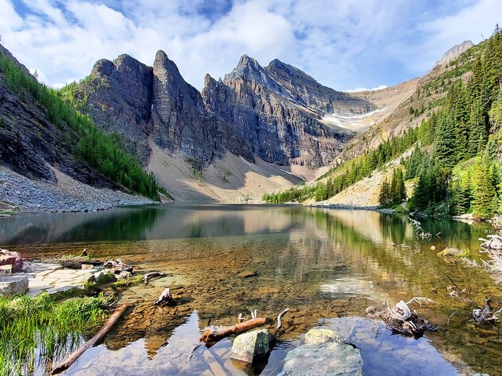
Hikes at Lake Louise: Well-known from many pictures and postcards, Lake Louise is a starting point for some rewarding hiking trails, the best of which is perhaps to the Plain of Six Glaciers.
Another very popular walk leads to Lake Agnes (difference in altitude 365 meters), which lies in a picturesque location between the two round hills known as the Beehives. The strenuous climb to the top of one of the Beehives is rewarded by a superb view over the entire area. In summer, the Lake Agnes Teahouse supplies food and drinks for hikers.
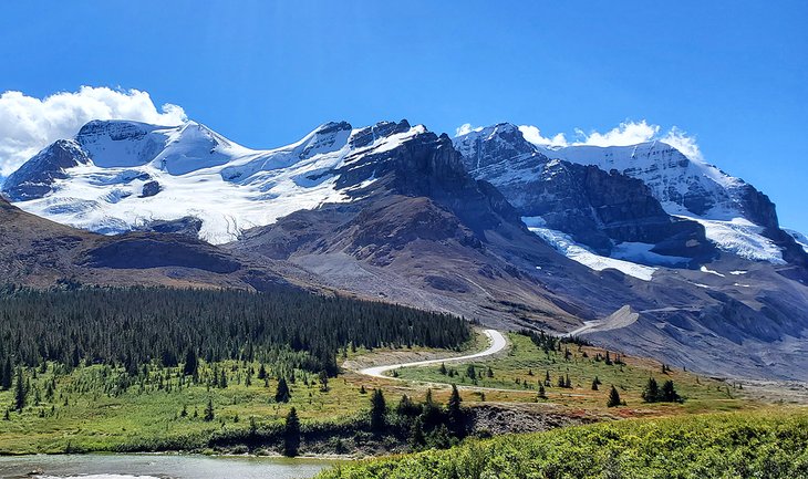
3. Drive the Icefields Parkway
Highlights: Glaciers, turquoise-colored lakes, fantastic hiking trails, and abundant wildlife
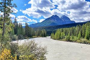
The Icefields Parkway (Highway 93) is one of the most scenic highways in Canada. It crosses the northern part of Banff National Park and the southern part of Jasper National Park and forms a link between Trans-Canada Highway 1 and Yellowhead Highway 16. Unlike the busy Trans-Canada Highway, the Icefields Parkway is purely and simply a sightseeing route through magnificent high mountain scenery.
From Lake Louise to Jasper, the road follows a narrow valley running north-south for 230 kilometers between the glaciated peaks of the main range of the Rocky Mountains. Frequent overlooks with parking places provide opportunities to enjoy the breathtaking views, and interpretive plaques fill in the background on the landscape and local history.
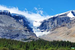
One of the major highlights along the Icefields Parkway is the Columbia Icefield. It's at this point where the Athabasca Glacier extends down from the heights above allowing for you to walk right up to the toe.
Bighorn sheep and mountain goats - at the roadside or on the mountain tops - romantic waterfalls, the shimmering turquoise waters of mountain lakes, looming icefields, and snow-clad mountain peaks all make for a journey of infinite variety.
You can drive your own vehicle or, if you'd rather have someone else do all the driving and provide insight as to the surroundings, consider taking the Athabasca Glacier Snow Trip from Banff. This tour covers the major highlights along the way and includes a trip out onto the surface of the glacier on an Ice Explorer tour, and the Glacier Skywalk.
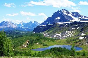
4. Hike the Best Trails in Banff National Park
Highlights: A mix of easy and challenging hikes to wonderful overlooks, waterfalls, and lakes
Hiking in Banff National Park allows you to get to some of the most spectacular locations in the park. Count on seeing one or all of the following on your hike: turquoise lakes, soaring mountain peaks, massive glaciers, wildlife, tumbling waterfalls, and deep valleys with rushing rivers.
Some of the most popular hikes in Banff National Park are Lake Agnes, the Big Beehive Trail, and Plain of Six Glaciers, all found in the Lake Louise area. Along the Icefields Parkway are Wilcox Pass and Parker Ridge, both of which offer beautiful glacier views. If you're up for a longer hike you want to consider Bow Falls or Sentinel Pass.
You can choose your own trail, or take a tour such as the classic hike from Banff trip. A knowledgeable guide will take you on one of four legendary hikes in the area and provide insight into the history, flora, and fauna that you'll see. Hotel pickup and drop off are included, as is a packed lunch.
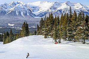
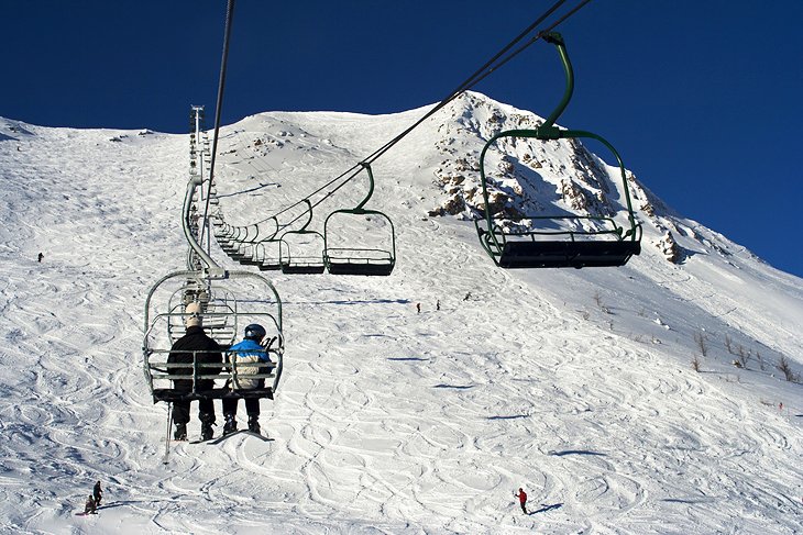
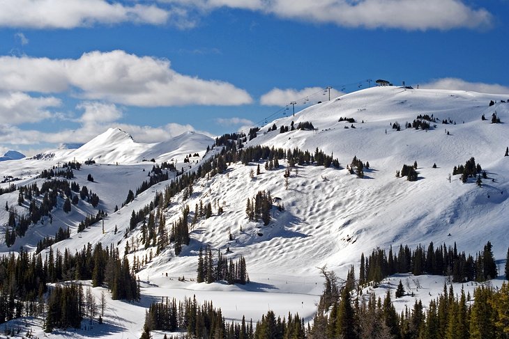
5. Hit the Slopes at Lake Louise Ski Resort
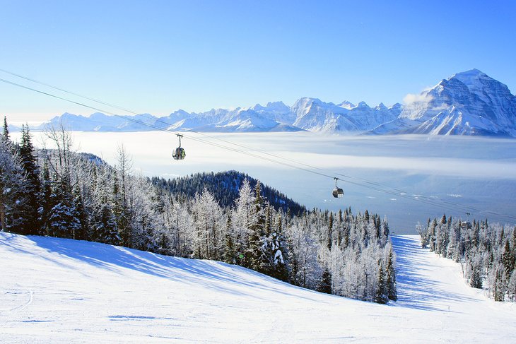
Highlights: Great skiing with long groomed runs, a sightseeing gondola in the summer
Lake Louise Ski Resort is the most well-known ski resort in Alberta, and also one of the best ski resorts in Canada. It offers skiing for all levels of ability with terrain that includes open bowls, groomed runs, and tree skiing. The runs on the mountainside are visible from the lake and Chateau Lake Louise.
Lake Louise Ski Resort has recently added a new chairlift, the Summit Quad, which makes accessing over 480 acres of new terrain easy. Skiers will rejoice at all this new terrain, which was formerly only accessible via an old (and brutal-to-ride) Poma lift.
During the summer months, the Lake Louise Sightseeing Gondola offers an easy way to get up into the alpine landscape. The gondola ascends to 2,088 meters, where there are opportunities to tackle some day hikes or short walks, or simply enjoy a meal.
The Whitehorn Bistro, at more than 2,000 meters, is open for lunch and breakfast at the top of the Sightseeing Lift. This restaurant has both indoor and outdoor dining and great views over the surrounding forest and beyond, the turquoise waters of Lake Louise.
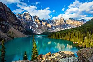
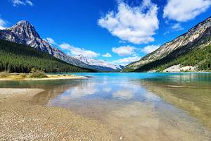
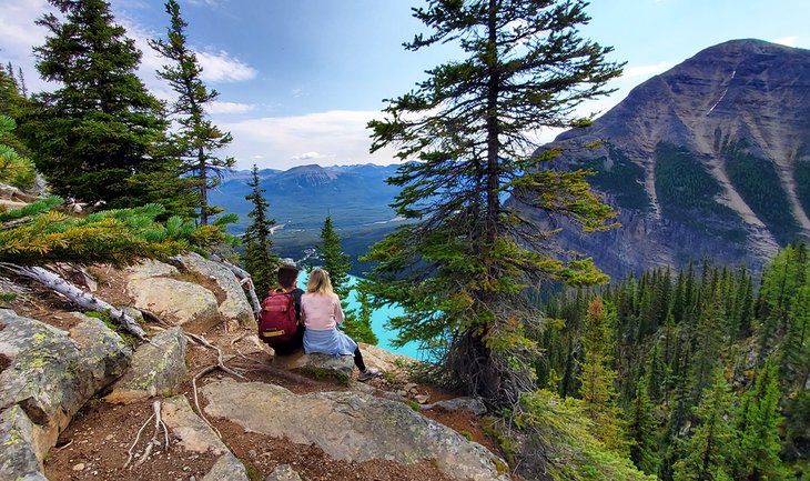
6. Gaze across Moraine Lake
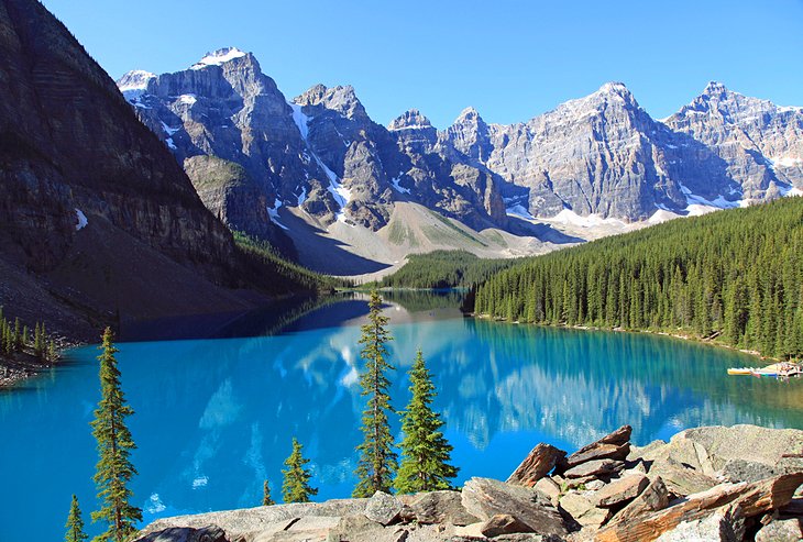
Highlights: A stunning alpine lake ringed by towering peaks, great hikes nearby
Pictured on the reverse of the old Canadian twenty-dollar bill, Moraine Lake in the Valley of the Ten Peaks is arguably as impressive as Lake Louise, but attracts fewer visitors. The picturesque turquoise-colored water is surrounded by ten peaks, each more than 3,000 meters high, and the Wenkchemna Glacier. The lake is located beyond Lake Louise, and the 13-kilometer road leading from Lake Louise up to Moraine Lake reveals one great view after another.
From near the parking area, a 1.5-kilometer-long walking trail runs along the northwest shore. This is a flat and easy walk. The most scenic walk involves a short climb up the Rockpile Trail to the best view of the lake, and the view most often seen on posters and postcards. This takes only about 20 minutes, but most people linger at the viewpoint. A popular, although strenuous, day hike leads from the lake to Sentinel Pass, one of the highest mountain passes in Banff National Park.
Accommodation, dining, and canoe rentals are available at the quaint Moraine Lake Lodge along the lakeshore.
The road to Moraine Lake is now closed to private vehicles. The only access is via shuttle bus from the Lake Louise Park and Ride Center, located off the Trans Canada Highway six kilometers from Lake Louise. Reservations for the shuttle bus are required and can be booked starting April 1st of each year.
Your ticket to Moraine Lake also includes a ride on the connector shuttle to Lake Louise.
7. Ski and Board at Sunshine Village Ski Resort
Highlights: The best snow in the park, wide open skiing, high-altitude summer hiking trails
Sunshine Village Ski Resort is just a short drive outside the town of Banff and is one of the top two ski resorts in Alberta, along with Lake Louise. The resort offers a variety of terrain and runs for beginners to advanced skiers.
Sunshine Village now runs its gondola in the summertime. Gone are long rides in old-school buses via the twisty, dusty access road. Now, you can easily step onto the gondola and gaze out at the scenery as you're whisked to the top.
From the base area, multiple hikes fan out to spectacular viewpoints. Highlights of these hikes are wide-open meadows filled with spring and summer flowers, wildlife encounters, and some of the best views in the park. A less taxing alternative is to ride to the very top of the Continental Divide on the Standish Express high-speed quad chairlift.
Getting to Sunshine is easy. Either drive to the parking area on your own or catch a free shuttle from the Banff town site.
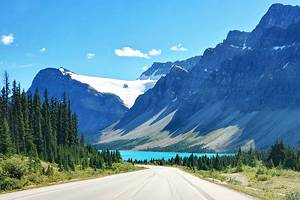
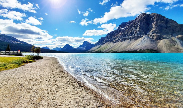
8. Make a Stop at Bow Lake
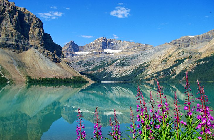
Highlights: A huge aquamarine glacier-fed lake perfect for photography and swimming, if you dare
Bow Lake, 34 kilometers north of Lake Louise, lies below the Crowfoot Glacier (shaped like a crow's foot and clearly visible from the road) and Bow Glacier. The lake's still and clear waters mirror the towering, snow-covered peaks of the continental divide.
These glaciers form part of the great Waputik Icefield. There are lovely walks along the lake to a waterfall at the foot of the Bow Glacier (half a day) or to Helen Lake and Catherine Lake at the Dolomite Pass to the east (whole day).
9. Enjoy the View over Peyto Lake
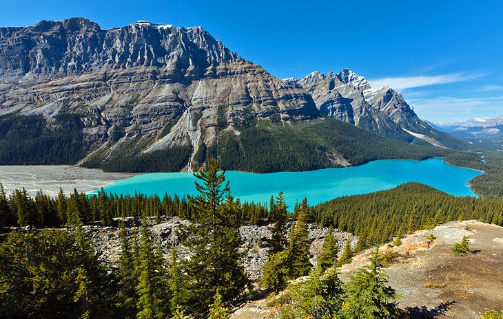
Highlight: Easily accessible viewpoint over an impressively blue lake framed by mountains and forests
At 2,068 meters, Bow Pass is the highest pass in Banff National Park and the watershed between the river systems of the North and South Saskatchewan Rivers. A short branch road leads to the magnificent Peyto Lake viewpoint, and another superb lookout point can be reached on foot about a kilometer from the parking area.
Peyto Lake is the unique turquoise color of many of the glacier-fed lakes in this area, and is especially lovely in mid to late summer, when Bow Summit's mountain meadows are carpeted with wildflowers.
A long, steep path from Bow Pass leads down for 2.5 kilometers to Peyto Lake, named after the mountain guide Bill Peyto, who began exploring the area in 1894 and took pack horses of supplies north over Bow Summit.
10. Sightsee along the Bow Valley Parkway
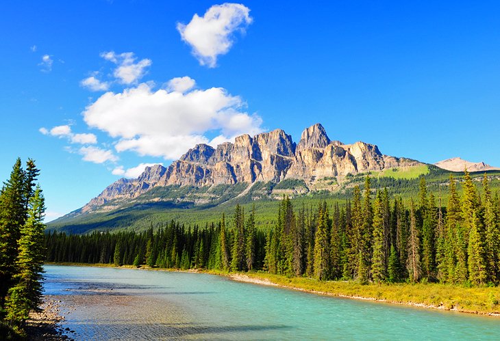
Highlights: Frequent animal sightings, Johnston Canyon, views to Castle Mountain
The 48-kilometer-long Bow Valley Parkway, which runs between Banff and Lake Louise, offers an alternative route to the busy Trans-Canada Highway. This route has numerous viewpoints as well as camping and picnic sites. Towering above it all is Castle Mountain, whose Eisenhower Peak is 2,728 meters high.
The Bow Valley Parkway also offers a great chance to see some of the park's wildlife. One of the most popular stops along the parkway is Johnston Canyon. When planning your trip, note that the Bow Valley Parkway is closed from March 1st to June 25th from 8pm to 8am. The route has a posted speed limit of 60 kilometers an hour, and this is strictly enforced.
11. Walk through Johnston Canyon
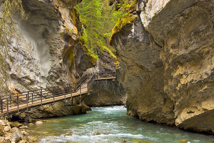
Highlights: An easy hiking trail, two waterfalls, and the blue-green Ink Pot springs
About 26 kilometers along the Bow Valley Parkway is the entrance to Johnston Canyon with its two waterfalls. A trail leads through the canyon, with bridges along the steep cliff walls. The path continues for six kilometers on the far side of the canyon, leading up to the Ink Pots, a group of springs. Two of these are particularly striking because of the bluish-green color of the water.
Most visitors just stick to the lower level, while those with more time and energy take on the more strenuous walk to the Ink Pots. Johnston Canyon is an impressive site in both summer and winter, although it sees very few visitors outside of the summer season.
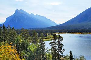
12. Lake Minnewanka
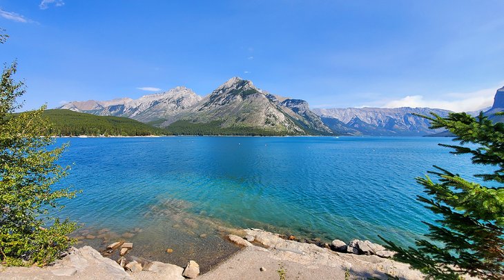
Highlights: Boat tours, pleasant hikes, challenging mountain biking, and a good place to spot wildlife
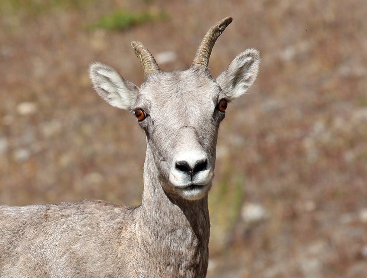
Lake Minnewanka, 11 kilometers northeast of Banff, is the largest lake within the national park and a scenic spot often frequented by bighorn sheep. A popular walking trail leads along the shore and up into the surrounding mountainside.
Lake Minnewanka is the only lake in the park on which motorboats are allowed. In summer, boat tours are offered.
It is also worthwhile going on to Two Jack Lake — where canoes can be rented — and Johnson Lake.
Lake Minnewanka is also a fantastic place for mountain biking. The trail running along the shoreline has heart-pumping ascents and technical sections, but the scenery makes the effort extended seem inconsequential.
13. Spot Wildlife in Banff National Park
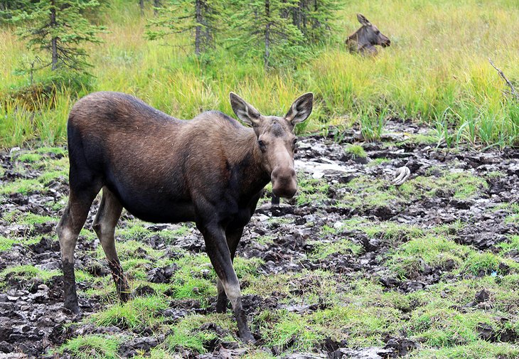
Highlights: Grizzly bears, black bears, big horn sheep, pikas, marmots, deer, and elk
Wildlife is one of the great tourist attractions of Banff National Park. More than fifty species of mammals are found in the national parks of this region.
Large animals are most likely to be spotted in the early morning and the evening. Some of the most commonly seen animals in the park are elk, bighorn sheep, moose, deer, woodland caribou, mountain goats, and black bears.
The park is also home to grizzly bears. Hiking trails are sometimes closed due to grizzlies in the area. Normally, they do not come near roads and towns. When walking in the "backcountry," it is wise to keep an eye open for them, as well as black bears.
The latter prefer wooded areas and thick undergrowth on the flat valley floors and sunny south-facing slopes, while grizzlies keep to the alpine regions in summer but seek food lower down in spring and autumn.
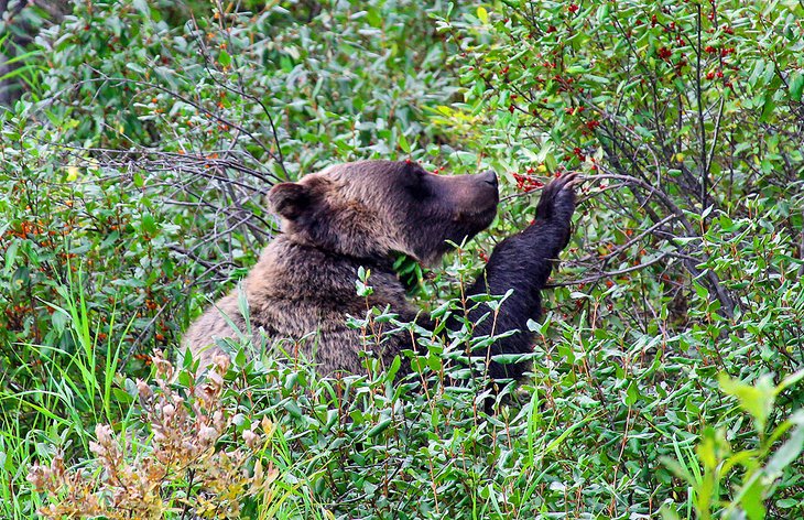
While it's rare, grizzlies have been known to come right down to Moraine Lake, on one of the busiest walking paths in the middle of the day, with large groups of people around. These animals have poor sight but can smell or hear approaching humans long before they see them. Bears can be surprisingly quick, so hikers should never approach one.
A great way to increase your chances of seeing some of these marvelous animals is on a Wildlife Tour, available during the summer months. This half-day tour is led by a professional guide and takes you to some of the best wildlife viewing areas around Banff.
Another option is to take an Evening Wildlife Safari. This tour leaves at dusk each evening, when the wildlife comes out to feed prior to dark. The tour claims a 95 percent success rate in spotting wildlife, which includes bighorn sheep, bears, deer, and elk.
14. Soak in Banff Upper Hot Springs
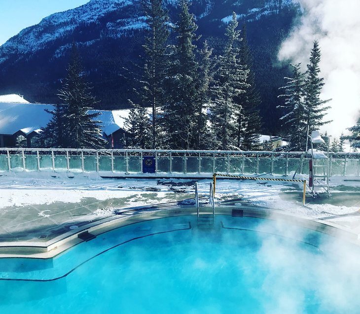
Highlights: Historic springs from the turn of the 20th century, fantastic views
Banff has long been known for its fantastic hot springs. Located just a short distance from downtown, the springs have been soothing visitors since 1893.
The water you'll enjoy is hundreds of years old and comes up from a source three kilometers underground. The view from the hot springs pools across to Rundle Mountain is spectacular.
The hot springs are open early and stay open late; bring your swimsuit and towel. If you don't have your own, rentals are available on-site for a nominal fee.
15. Cave and Basin National Historic Site
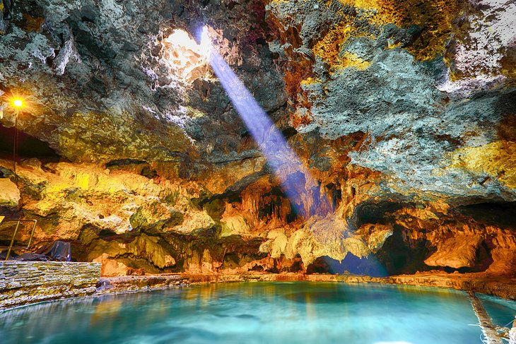
Highlights: Informative and interactive displays, hikes, and a 4-D movie
Cave and Basin National Historic Site is the birthplace of Banff National Park. It was here that the national park system was created to protect Canada's special places.
A self-guided trail leads past the original 1914 bathing structure and the site of the former hotel. Included with the admission is a 4D movie showcasing Banff and other national parks.
Cave and Basin Natural Historic Site has several delightful hikes. The 2.8-kilometer Marsh Trail showcases exotic flowers, while the Sundance Trail/Sundance Canyon Trail provides wonderful views across the Bow River valley.
Best Time to Visit Banff National Park
The best time to visit Banff National Park is in the summer months of July and August. The weather is at its warmest, with daytime temperatures comfortable in the low 20s Celsius. Nights are generally cool to cold, even in the peak of summer, owing to the mountain environment and the elevation of the park.
That said, if you can time it, the ultimate time to visit the park is during the three weeks running from mid-July to the first week of August. At this time all the high-elevation hikes will be accessible, the lakes will be at their most colorful, and all the alpine wildflowers will be in full bloom.
September is also a good time to visit — the crowds will have dispersed, and you'll get sunny skies along with color changes on the deciduous and tamarack trees. June has the longest days, but the weather is very changeable and some lakes may still be frozen.
Give the months of October, November, April, and May a pass. All the trails are closed or very muddy and the weather is cold and wet.
The winter months of December, January, February, and March are good options if you want to go downhill skiing. However, try and time your ski trip for March — January and early February can be bone-numbingly cold with short days.